
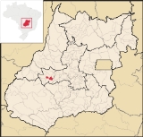
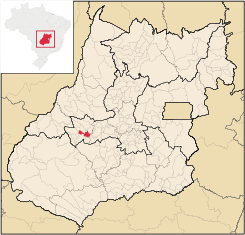
Moiporá
Encyclopedia
| Moiporá | |
|---|---|
| State | Goiás Goiás Goiás is a state of Brazil, located in the central part of the country. The name Goiás comes from the name of an indigenous community... |
| Area: | 460.6 km² (10/10/2002) |
| Population: | 1,848 (IBGE 2007) |
| Urban population: | 1,241 (2007) |
| Population density: | 4.01 inhab/km² (2007) |
| Elevation: | 678m above sea level |
| Postcode (CEP): | 76135-000 |
| Became a city: | 1958 |
| Mayor: | Ricardo Alves Ferreira (January 2005) |
| IBGE statistical Microregion: | Iporá Microregion Iporá Microregion The Iporá Microregion is a geographical region in central-western Goiás state, Brazil. The most important city is Iporá. For a map see -Important Data :*Population: 58,845 *Cities: 10*Total Area: 7,096.60 km²... |
| Distance to Goiânia Goiânia -Climate:The city has a tropical wet and dry climate with an average temperature of . There's a wet season, from October to April, and a dry one, from May to September. Annual rainfall is around 1,520 mm.... : |
160 km. |
| Website: | none (March 2008) |
| Coordinates: | 16°32′26"S 50°43′36"W |
Town
A town is a human settlement larger than a village but smaller than a city. The size a settlement must be in order to be called a "town" varies considerably in different parts of the world, so that, for example, many American "small towns" seem to British people to be no more than villages, while...
and municipality
Municipality
A municipality is essentially an urban administrative division having corporate status and usually powers of self-government. It can also be used to mean the governing body of a municipality. A municipality is a general-purpose administrative subdivision, as opposed to a special-purpose district...
in eastern Goiás
Goiás
Goiás is a state of Brazil, located in the central part of the country. The name Goiás comes from the name of an indigenous community...
state, Brazil
Brazil
Brazil , officially the Federative Republic of Brazil , is the largest country in South America. It is the world's fifth largest country, both by geographical area and by population with over 192 million people...
.
Distances and Highway Connections
- Distance to the state capital: 160 km.
- Distance to regional center (IporáIporáIporá is a small city and municipality in west-central Goiás state, Brazil. The population was 31,060 in a total area of 1,026.4 km² . It is known as the City of the Clear Waters because of its many streams and rivers.-Location:...
): 76 km. - Highway connections: state highway BR-069 west from GoiâniaGoiânia-Climate:The city has a tropical wet and dry climate with an average temperature of . There's a wet season, from October to April, and a dry one, from May to September. Annual rainfall is around 1,520 mm....
, through TrindadeTrindade-Transportation:Trindade are linked with São Tomé and Príncipe's only highways linking to the capital city of São Tomé, another linking Neves and Santana and another linking to Guadalupe as well....
, São Luís de Montes BelosSão Luís de Montes BelosSão Luís de Montes Belos is a small city and municipality in the State of Goiás, Brazil.-Location:It is located in the Anicuns Microregion, 123 kilometers from the state capital, Goiânia, to which it is connected by highway GO-060...
, and then GO-444 for 44 kilometers to Moiporá. For the complete list of distances see Seplan
Municipal Boundaries
Neighboring municipalities: IporáIporá
Iporá is a small city and municipality in west-central Goiás state, Brazil. The population was 31,060 in a total area of 1,026.4 km² . It is known as the City of the Clear Waters because of its many streams and rivers.-Location:...
, Córrego do Ouro
Córrego do Ouro
Córrego do Ouro is a small town and municipality in eastern Goiás state, Brazil.-Location and Highway Connections:Córrego do Ouro is located in the Iporá Microregion west of the state capital, Goiânia. It is 45 km. northwest of São Luís de Montes Belos, the largest town in the region. ...
, Cachoeira de Goiás
Cachoeira de Goiás
Cachoeira de Goiás is a small town and municipality in eastern Goiás state, Brazil.-Location:*Distance to the state capital: 172 km.*Distance to regional center : 77 km....
, Ivolândia
Ivolândia
Ivolândia is a small town and municipality in eastern Goiás state, Brazil. The population was 2,718 in a total area of 1,262.8 km² .-Location:*Distance to regional center : 56 km....
, Aurilândia
Aurilândia
Aurilândia is a small town and municipality in eastern Goiás state, Brazil.-Location:The distance to the state capital is 146 km. while the distance to the main regional center São Luís de Montes Belos is 23 km....
, and Israelândia
Israelândia
Israelândia is a small town and municipality in eastern Goiás state, Brazil.-Location:Israelândia is located in the Iporá Microregion, 28 km. northeast of regional center Iporá. State capital Goiânia is 199 km. to the east...
.
Economic Information
The economy was based on services, public employment, small transformation industries, cattle raising, and agriculture. In 2005 there were 3 industrial units and 20 retail units. The sector employing more workers was public administration with 153 workers in 2003. There were no financial institutions in 2007.- GDP (PIB) (R$ 1,000.00): 12,373 (2005)
- GDP per capita (R$ 1.00): 6,588 (2005)
In 2006 there were 50,000 head of cows, of which 4,350 were milk cows. Swine, poultry, egg, and milk production were modest. The main agricultural products in planted area were rice, bananas, manioc, and corn. None exceeded 500 planted hectares.
Agricultural data 2006
- Farms: 235
- Total area: 37,042 ha.
- Area of permanent crops: 41 ha.
- Area of perennial crops: 417 ha.
- Area of natural pasture: 28,356 ha.
- Area of woodland and forests: 7,450 ha.
- Persons dependent on farming: 700
- Farms with tractors: 25
- Number of tractors: 37
- Cattle herd: 92,000 head IBGE
Health and education
In 2007 there were no hospitals and only 4 walk-in health clinics. The infant mortality rate was 28.88 for every 1,000 live births in 2000.In 2006 the school system had 4 schools, 20 classrooms, 23 teachers, and 399 students. There were no institutions of higher learning. The adult literacy rate was 85.7% in 2000.
- Municipal Human Development IndexHuman Development IndexThe Human Development Index is a composite statistic used to rank countries by level of "human development" and separate "very high human development", "high human development", "medium human development", and "low human development" countries...
: 0.730 - State ranking: 144 (out of 442 municipalities in 2000)
- National ranking: 2,418 (out of 5,507 municipalities in 2000)
History
The region was settled in 1930 by Sebastião Moreira da Silva and his children who built the first huts in an area of fertile lands and perennial springs. With the arrival of new settlers a village (arraial) was formed called "Cobó", the name given to the knife that Silva used to keep away creditors who wanted to charge him. In 1953 the settlement became a district belonging to AurilândiaAurilândia
Aurilândia is a small town and municipality in eastern Goiás state, Brazil.-Location:The distance to the state capital is 146 km. while the distance to the main regional center São Luís de Montes Belos is 23 km....
and was called Moiporá, a combination of Moitu (Cachoeira de Goiás) and Iporá
Iporá
Iporá is a small city and municipality in west-central Goiás state, Brazil. The population was 31,060 in a total area of 1,026.4 km² . It is known as the City of the Clear Waters because of its many streams and rivers.-Location:...
, a neighboring municipality. In 1958 it was dismembered from Aurilândia and made a municipality.