

Indiana State Road 64
Encyclopedia
State Road 64 in the U.S. State
U.S. state
A U.S. state is any one of the 50 federated states of the United States of America that share sovereignty with the federal government. Because of this shared sovereignty, an American is a citizen both of the federal entity and of his or her state of domicile. Four states use the official title of...
of Indiana
Indiana
Indiana is a US state, admitted to the United States as the 19th on December 11, 1816. It is located in the Midwestern United States and Great Lakes Region. With 6,483,802 residents, the state is ranked 15th in population and 16th in population density. Indiana is ranked 38th in land area and is...
is an east–west highway that crosses most of the southern portion of the state, covering a distance of about 107 miles (172.2 km).
Route description
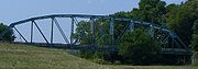
State Road 64 begins at a bridge across the Wabash RiverWabash River
The Wabash River is a river in the Midwestern United States that flows southwest from northwest Ohio near Fort Recovery across northern Indiana to southern Illinois, where it forms the Illinois-Indiana border before draining into the Ohio River, of which it is the largest northern tributary...
at Mount Carmel, Illinois
Mount Carmel, Illinois
Mount Carmel is a city in and the county seat of Wabash County, Illinois, United States. At the time of the 2000 census, the population was 7,982, while the next largest town in Wabash County is Allendale, population 528. Located at the confluence of the Wabash, Patoka, and White Rivers, Mount...
, connecting it with Illinois Route 15
Illinois Route 15
Illinois Route 15 is an east–west highway with its western terminus at Illinois Route 3, U.S. Route 40, I-55, I-64, and I-70 and its eastern terminus at Wabash River at the Illinois/Indiana Border where it meets Indiana 64. This is a distance of ....
. It ends at Interstate 64
Interstate 64
Interstate 64 is an Interstate Highway in the Midwestern and Southeastern United States. Its western terminus is at I-70, U.S. 40, and U.S. 61 in Wentzville, Missouri. Its eastern terminus is at an interchange with I-264 and I-664 at Bowers Hill in Chesapeake, Virginia. As I-64 is concurrent with...
near Edwardsville
Edwardsville, Indiana
Edwardsville is an unincorporated community in Georgetown Township, Floyd County, Indiana....
. For the bulk of its length, it runs parallel to Interstate 64 and approximately 30 miles (48.3 km) north of the it. Most of the route is two-lane undivided highway, with undivided multi-lane segments in the city of Princeton
Princeton, Indiana
The median income for a household in the city was $26,689, and the median income for a family was $37,308. Males had a median income of $28,076 versus $19,825 for females. The per capita income for the city was $15,049...
near the junction of U.S. Route 41
U.S. Route 41
U.S. Route 41 is a north–south United States Highway that runs from Miami, Florida to the Upper Peninsula of Michigan. Until 1949, the part in southern Florida, from Naples to Miami, was U.S...
, and through the city of Huntingburg
Huntingburg, Indiana
-Notable people:* Baseball pitcher Alex Graman was born in Huntingburg.* Milwaukee Brewers pitcher Mitch Stetter was born and raised in Huntingburg.* Retired professional basketball player Don Buse was born in Huntingburg.* Gordon St...
.
The stretch of State Road 64 between Princeton and Mount Carmel is scheduled to be transformed into a four-lane highway sometime around 2012 as part of Governor Mitch Daniels
Mitch Daniels
Mitchell Elias "Mitch" Daniels, Jr. is the 49th and current Governor of the U.S. state of Indiana. A Republican, he began his first four-year term as governor on January 10, 2005, and was elected to his second term by an 18-point margin on November 4, 2008. Previously, he was the Director of the...
' Major Moves
Major Moves
Major Moves is a studio album by American country music artist Hank Williams, Jr. It was released by Warner Bros. Records in May 1984. "Attitude Adjustment," "All My Rowdy Friends Are Coming Over Tonight" and the title track were released as singles...
Project. This stretch of IN-64, currently a two-lane highway is often a very congested and sometimes very dangerous stretch of highway with numerous crosses along it referring to the stretch's numerous casualties.
At the western end of this stretch are two very narrow bridges that typically handle at least 900-1200 vehicles a day, doubling to ~2000 a day vehicles during Mount Carmel's Ag Days, Lone Ranger Festival, and other holidays. The road is heavily used by commuters to the Gibson Generating Station
Gibson Generating Station
The Gibson Generating Station is a coal-burning power plant located at the northern end of northern Montgomery Township, Gibson County, Indiana, United States. It is close to the Wabash River, just opposite Mount Carmel, Illinois...
and residents of Mount Carmel and nearby cities in Illinois commuting to Princeton and cities and factories along U.S. Route 41
U.S. Route 41
U.S. Route 41 is a north–south United States Highway that runs from Miami, Florida to the Upper Peninsula of Michigan. Until 1949, the part in southern Florida, from Naples to Miami, was U.S...
. In April 2008 excavation began on a bridge to replace the current one spanning the Wabash River, and the bridge was completed in December 2010.