

Indiana State Road 57
Encyclopedia
State Road 57 in the U.S. State
of Indiana
is a north–south, largely two-lane road in the southwestern portion of the state.
in Evansville
and provides access to Evansville Regional Airport
. It overlaps the Interstate 164
Evansville by-pass for that highway's final three miles (5 km), to the junction with Interstate 64
. The highway serves a number of small communities and the cities of Petersburg and Washington. The final few miles of State Road 57 overlap U.S. Route 231
. State Road 57 ends at the south junction of U.S. 231 and State Road 67, three miles (5 km) southwest of Worthington
. A large portion of State Road 57 is planned to be bypassed by the extension of Interstate 69
, with construction starting at the I-64/I-164 interchange in mid-2008.
In 2009, a portion of Indiana 57 was relocated onto the new Interstate 69
route and concurred with Indiana 68. The original route has been removed and now only exists as a service road to the Warrick County Industrial Park.
U.S. state
A U.S. state is any one of the 50 federated states of the United States of America that share sovereignty with the federal government. Because of this shared sovereignty, an American is a citizen both of the federal entity and of his or her state of domicile. Four states use the official title of...
of Indiana
Indiana
Indiana is a US state, admitted to the United States as the 19th on December 11, 1816. It is located in the Midwestern United States and Great Lakes Region. With 6,483,802 residents, the state is ranked 15th in population and 16th in population density. Indiana is ranked 38th in land area and is...
is a north–south, largely two-lane road in the southwestern portion of the state.
Route description
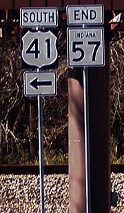
State Road 57 begins at U.S. Route 41U.S. Route 41
U.S. Route 41 is a north–south United States Highway that runs from Miami, Florida to the Upper Peninsula of Michigan. Until 1949, the part in southern Florida, from Naples to Miami, was U.S...
in Evansville
Evansville, Indiana
Evansville is the third-largest city in the U.S. state of Indiana and the largest city in Southern Indiana. As of the 2010 census, the city had a total population of 117,429. It is the county seat of Vanderburgh County and the regional hub for both Southwestern Indiana and the...
and provides access to Evansville Regional Airport
Evansville Regional Airport
Evansville Regional Airport is a public airport located three miles north of the central business district of Evansville, a city in Vanderburgh County, Indiana, United States. This airport is publicly owned by Evansville/Vanderburgh Airport Authority.It provides nearly 30 daily flights to and...
. It overlaps the Interstate 164
Interstate 164
Interstate 164 is a spur highway of Interstate 64 in Evansville, Indiana. Interstate 164, also known as the Robert D. Orr Highway, has a total length of...
Evansville by-pass for that highway's final three miles (5 km), to the junction with Interstate 64
Interstate 64
Interstate 64 is an Interstate Highway in the Midwestern and Southeastern United States. Its western terminus is at I-70, U.S. 40, and U.S. 61 in Wentzville, Missouri. Its eastern terminus is at an interchange with I-264 and I-664 at Bowers Hill in Chesapeake, Virginia. As I-64 is concurrent with...
. The highway serves a number of small communities and the cities of Petersburg and Washington. The final few miles of State Road 57 overlap U.S. Route 231
U.S. Route 231
U.S. Route 231 is a parallel route of U.S. Route 31. It currently runs for 912 miles from St. John, Indiana, at U.S. Route 41 to south of U.S. Route 98 in Downtown Panama City, Florida.One of its most notable landmarks is the William H...
. State Road 57 ends at the south junction of U.S. 231 and State Road 67, three miles (5 km) southwest of Worthington
Worthington, Indiana
Worthington is a town in Jefferson Township, Greene County, Indiana, United States. The population was 1,481 at the 2000 census. It is part of the Bloomington, Indiana, Metropolitan Statistical Area.-Geography:...
. A large portion of State Road 57 is planned to be bypassed by the extension of Interstate 69
Interstate 69
Interstate 69 is an Interstate Highway in the United States. It exists in two parts: a completed highway from Indianapolis, Indiana, northeast to the Canadian border in Port Huron, Michigan, and a mostly proposed extension southwest to the Mexican border in Texas...
, with construction starting at the I-64/I-164 interchange in mid-2008.
In 2009, a portion of Indiana 57 was relocated onto the new Interstate 69
Interstate 69
Interstate 69 is an Interstate Highway in the United States. It exists in two parts: a completed highway from Indianapolis, Indiana, northeast to the Canadian border in Port Huron, Michigan, and a mostly proposed extension southwest to the Mexican border in Texas...
route and concurred with Indiana 68. The original route has been removed and now only exists as a service road to the Warrick County Industrial Park.