
Indiana State Road 68
Encyclopedia
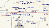
State Road 68 in the U.S. State
of Indiana
is a 53 miles (85.3 km) route in Gibson
, Posey
, Spencer
and Warrick
counties.
at State Road 69
and runs east, passing through the towns of Poseyville
, Cynthiana
, Haubstadt
, Lynnville
and Selvin. State Road 68 nearly parallels Interstate 64
, but although it passes over the interstate twice, there is no direct interchange. It ends at US 231
in the town of Dale
.
U.S. state
A U.S. state is any one of the 50 federated states of the United States of America that share sovereignty with the federal government. Because of this shared sovereignty, an American is a citizen both of the federal entity and of his or her state of domicile. Four states use the official title of...
of Indiana
Indiana
Indiana is a US state, admitted to the United States as the 19th on December 11, 1816. It is located in the Midwestern United States and Great Lakes Region. With 6,483,802 residents, the state is ranked 15th in population and 16th in population density. Indiana is ranked 38th in land area and is...
is a 53 miles (85.3 km) route in Gibson
Gibson County, Indiana
Gibson County is a county located in the southwestern part of the U.S. state of Indiana and is included in the Evansville, Indiana–Kentucky Metropolitan Statistical Area. As of 2010, the population was 33,503. The county seat is Princeton.-Geography:...
, Posey
Posey County, Indiana
As of the census of 2000, there were 27,061 people, 10,205 households, and 7,612 families residing in the county. The population density was 66 people per square mile . There were 11,076 housing units at an average density of 27 per square mile...
, Spencer
Spencer County, Indiana
As of the census of 2000, there were 20,391 people, 7,569 households, and 5,752 families residing in the county. The population density was 51 people per square mile . There were 8,333 housing units at an average density of 21 per square mile...
and Warrick
Warrick County, Indiana
As of the census of 2000, there were 52,383 people, 19,438 households, and 15,181 families residing in the county. The population density was 136 people per square mile . There were 20,546 housing units at an average density of 54 per square mile...
counties.
Route description
State Road 68 begins in New HarmonyNew Harmony, Indiana
New Harmony is a historic town on the Wabash River in Harmony Township, Posey County, Indiana, United States. It lies north of Mount Vernon, the county seat. The population was 916 at the 2000 census. It is part of the Evansville metropolitan area. Many of the old Harmonist buildings still stand...
at State Road 69
Indiana State Road 69
State Road 69 is a route that runs from south to north through western Posey County in the southwestern corner of the U.S. state of Indiana.-Route description:...
and runs east, passing through the towns of Poseyville
Poseyville, Indiana
Poseyville is a town in Robb Township, Posey County, Indiana, United States. The population was 1,187 at the 2000 census.-Geography:Poseyville is located at ....
, Cynthiana
Cynthiana, Indiana
Cynthiana is a town in Smith Township, Posey County, Indiana, United States. The population was 545 at the 2010 census. It was founded in 1817 and named for Cynthiana, Kentucky, where the first settlers had come from.-Geography:...
, Haubstadt
Haubstadt, Indiana
Haubstadt is a town in Johnson Township, Gibson County, Indiana, United States. The population was 1,529 at the 2000 census.-Geography:Haubstadt is located at ....
, Lynnville
Lynnville, Indiana
Lynnville is a town in Hart Township, Warrick County, Indiana, United States. The population was 781 at the 2000 census.-Geography:Lynnville is located at ....
and Selvin. State Road 68 nearly parallels Interstate 64
Interstate 64
Interstate 64 is an Interstate Highway in the Midwestern and Southeastern United States. Its western terminus is at I-70, U.S. 40, and U.S. 61 in Wentzville, Missouri. Its eastern terminus is at an interchange with I-264 and I-664 at Bowers Hill in Chesapeake, Virginia. As I-64 is concurrent with...
, but although it passes over the interstate twice, there is no direct interchange. It ends at US 231
U.S. Route 231
U.S. Route 231 is a parallel route of U.S. Route 31. It currently runs for 912 miles from St. John, Indiana, at U.S. Route 41 to south of U.S. Route 98 in Downtown Panama City, Florida.One of its most notable landmarks is the William H...
in the town of Dale
Dale, Indiana
Dale is a town in Carter Township, Spencer County, Indiana, United States. The population was 1,593 at the 2010 census. Founded in 1843 and initially called Elizabeth, it was renamed after Robert Dale Owen of New Harmony, the town's congressman at the time....
.