

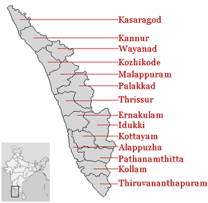
Districts of Kerala
Encyclopedia
India
India , officially the Republic of India , is a country in South Asia. It is the seventh-largest country by geographical area, the second-most populous country with over 1.2 billion people, and the most populous democracy in the world...
n state of Kerala
Kerala
or Keralam is an Indian state located on the Malabar coast of south-west India. It was created on 1 November 1956 by the States Reorganisation Act by combining various Malayalam speaking regions....
borders with the states of Tamil Nadu
Tamil Nadu
Tamil Nadu is one of the 28 states of India. Its capital and largest city is Chennai. Tamil Nadu lies in the southernmost part of the Indian Peninsula and is bordered by the union territory of Pondicherry, and the states of Kerala, Karnataka, and Andhra Pradesh...
on the south and east, Karnataka
Karnataka
Karnataka , the land of the Kannadigas, is a state in South West India. It was created on 1 November 1956, with the passing of the States Reorganisation Act and this day is annually celebrated as Karnataka Rajyotsava...
on the north and the Arabian Sea
Arabian Sea
The Arabian Sea is a region of the Indian Ocean bounded on the east by India, on the north by Pakistan and Iran, on the west by the Arabian Peninsula, on the south, approximately, by a line between Cape Guardafui in northeastern Somalia and Kanyakumari in India...
coastline on the west. The Western Ghats
Western Ghats
The Western Ghats, Western Ghauts or the Sahyādri is a mountain range along the western side of India. It runs north to south along the western edge of the Deccan Plateau, and separates the plateau from a narrow coastal plain along the Arabian Sea. The Western Ghats block rainfall to the Deccan...
, bordering the eastern boundary of the State, form an almost continuous mountain wall, except near Palakkad
Palakkad
Palakkad , formerly known as Palghat, is a municipality and a town in the state of Kerala in southern India, spread over an area of 26.60 km2.The city is situated about north of state capital Thiruvananthapuram. It is the administrative headquarters of Palakkad District...
where there is a natural mountain pass known as the Palakkad Gap
Palakkad Gap
Palakkad Gap is a 30-40 kilometers wide low mountain pass in the Western Ghats, near Palakkad town in the South Indian State of Kerala. It has an elevation of . The hills rise to 1100m to the North of the gap, and 2000m to the South. The average height of the gap is 144m.The gap is the lowest...
. When the independent India amalgamated small states together Travancore and Cochin states were integrated to form Travancore-Cochin state on 1 July 1949. However, Malabar remained under the Madras province. The States Reorganisation Act
States Reorganisation Act
The States Reorganisation Act of 1956 was a major reform of the boundaries and governance of India's states and territories. The act reorganised the boundaries of India's states along linguistic lines, and amended the Indian Constitution to replace the three types of states, known as Parts A, B,...
of 1 November 1956 elevated Kerala to statehood.
The state of Kerala
Kerala
or Keralam is an Indian state located on the Malabar coast of south-west India. It was created on 1 November 1956 by the States Reorganisation Act by combining various Malayalam speaking regions....
is divided into 14 revenue district
District
Districts are a type of administrative division, in some countries managed by a local government. They vary greatly in size, spanning entire regions or counties, several municipalities, or subdivisions of municipalities.-Austria:...
s. On the basis of geographical, historical and cultural similarities, the districts are generally grouped into Malabar (Northern Kerala) (Kasaragod
Kasaragod district
Kasaragod District is one of the districts of the Indian state of Kerala. Kasaragod District was organised as a separate district on 24 May 1984...
, Kannur
Kannur
Kannur , also known as Cannanore, is a city in Kannur district in the Indian state of Kerala. It is the administrative headquarters of the District of Kannur and 518km north of state capital Trivandrum. During British rule in India, Kannur was known by its old name Cannanore, which is still in...
, Wayanad, Kozhikkode, Malappuram
Malappuram
Malappuram is a municipality in the South Indian state of Kerala, spread over an area of 33.61 km2. It serves as the administrative headquarters of Malappuram district. As per the 2011 census Malappuram urban agglomeration is the fourth largest UA in kerala with a total population of...
); Kochi Region
Kochi
-Places:* Kochi, a city in the state of Kerala, India, formerly known as Cochin* Kingdom of Cochin, a former feudal city-state on Malabar Coast, India** Fort Kochi, one of the three main urban components which constitute the present day city of Kochi, Kerala, India...
(Central Kerala) (Palakkad
Palakkad
Palakkad , formerly known as Palghat, is a municipality and a town in the state of Kerala in southern India, spread over an area of 26.60 km2.The city is situated about north of state capital Thiruvananthapuram. It is the administrative headquarters of Palakkad District...
, Thrissur
Thrissur
This article is about the city in India. For the district, see Thrissur district. For the urban agglomeration area of Thrissur see Thrissur Metropolitan Area...
, Eranakulam); and Travancore
Travancore
Kingdom of Travancore was a former Hindu feudal kingdom and Indian Princely State with its capital at Padmanabhapuram or Trivandrum ruled by the Travancore Royal Family. The Kingdom of Travancore comprised most of modern day southern Kerala, Kanyakumari district, and the southernmost parts of...
(South Kerala) (Thiruvananthapuram
Thiruvananthapuram
Thiruvananthapuram , formerly known as Trivandrum, is the capital of the Indian state of Kerala and the headquarters of the Thiruvananthapuram District. It is located on the west coast of India near the extreme south of the mainland...
, Kollam
Kollam
Kollam , often anglicized as ', is a city in the Indian state of Kerala. The city lies on the banks of Ashtamudi Lake on the Arabian sea coast and is situated about north of the state capital, Thiruvananthapuram...
, Alappuzha
Alappuzha
Alappuzha , also known as Alleppey, is a town in Alappuzha District of Kerala state of southern India. As per 2001 census Alleppey is the sixth largest city in Kerala with an urban population of 177,029. Alleppey is situated to the south of Kochi and north of Trivandrum...
, Pathanamthitta
Pathanamthitta
Pathanamthitta is a large town and a municipality situated in the central Travancore region in the state of Kerala, south India, spread over an area of 23.50 km2. It is the administrative capital of Pathanamthitta district. The city has a population of 38,000...
, Kottayam
Kottayam
Kottayam is a city in the Indian state of Kerala, spread over an area of 55.40 km2. It is the administrative capital of the Kottayam district. Kottayam Kottayam (Malayalam: കോട്ടയം) is a city in the Indian state of Kerala, spread over an area of 55.40 km2. It is the administrative...
, Idukki). Such a regional division occurred being part of historical Kingdoms of Kochi, Travancore and British Province of Malabar. The Travancore region is again divided into 3 zones as Northern Travancore
Northern Travancore
The Northern Travancore, Kerala, consists of a part of Ernakulam district, and a part of Idukki district. These places were the part of Travancore kingdom before the Indian Independence.-Important Cities and Towns in Travancore:Ernakulam District...
(Hill Range) (Pathanamthitta
Pathanamthitta
Pathanamthitta is a large town and a municipality situated in the central Travancore region in the state of Kerala, south India, spread over an area of 23.50 km2. It is the administrative capital of Pathanamthitta district. The city has a population of 38,000...
and Idukki), Central Travancore
Central Travancore
The Central Travancore, Kerala, consists of the South-Central districts of Kottayam, Alapuzha, Pathanamthitta, and parts of Idukki, and parts of Kollam...
(Central Range) (Alappuzha
Alappuzha
Alappuzha , also known as Alleppey, is a town in Alappuzha District of Kerala state of southern India. As per 2001 census Alleppey is the sixth largest city in Kerala with an urban population of 177,029. Alleppey is situated to the south of Kochi and north of Trivandrum...
and Kottayam
Kottayam
Kottayam is a city in the Indian state of Kerala, spread over an area of 55.40 km2. It is the administrative capital of the Kottayam district. Kottayam Kottayam (Malayalam: കോട്ടയം) is a city in the Indian state of Kerala, spread over an area of 55.40 km2. It is the administrative...
) and Southern Travancore
Southern Travancore
The Southern Travancore, Kerala, consists of a part of Kollam district, Thiruvananthapuram district, and Kanyakumari district that is now in the state of Tamil Nadu...
(South Range) (Thiruvananthapuram
Thiruvananthapuram
Thiruvananthapuram , formerly known as Trivandrum, is the capital of the Indian state of Kerala and the headquarters of the Thiruvananthapuram District. It is located on the west coast of India near the extreme south of the mainland...
and Kollam
Kollam
Kollam , often anglicized as ', is a city in the Indian state of Kerala. The city lies on the banks of Ashtamudi Lake on the Arabian sea coast and is situated about north of the state capital, Thiruvananthapuram...
). Almost all of the districts in Kerala have the same name as the important town or city in the district, the exception being Wayanad district
Wayanad District
Wayanad District in the north-east of Kerala, India, was formed on November 1, 1980 as the 12th district by carving out areas from Kozhikode and Kannur districts. Kalpetta is the district headquarters as well as the only municipal town in the district. The region was known as Mayakshetra in the...
. The 14 districts are further divided into 62 taluks
Taluks of Kerala
In Kerala the administrative divisions below the district are called taluk. There are 63 taluks.There is a huge demand for Thiruvambady and Angamaly Taluk recently....
, 999 revenue villages and 1007 Gram panchayat
Gram panchayat
Gram panchayats are local self-governments at the village or small town level in India. As of 2002 there were about 265,000 gram panchayats in India. The gram panchayat is the foundation of the Panchayat System. A gram panchayat can be set up in villages with minimum population of 300...
s. Some of the districts and their towns were renamed in 1990 like Thiruvananthapuram
Thiruvananthapuram district
Thiruvananthapuram District is the southernmost district of the Indian state of Kerala. It came into existence in the year 1957. The headquarters is the city of Thiruvananthapuram which is also the capital city of Kerala....
(formerly
Anglicisation
Anglicisation, or anglicization , is the process of converting verbal or written elements of any other language into a form that is more comprehensible to an English speaker, or, more generally, of altering something such that it becomes English in form or character.The term most often refers to...
known as Trivandrum), Kollam
Kollam district
-Climate:Kollam's temperature is almost steady throughout the year. The average temperature ranges from 25 to 32 degrees Celsius. Summer usually runs from March until May; the monsoon begins by June and ends by September. Kollam receives an annual average rainfall of around...
(Quilon), Alappuzha
Alappuzha district
Alappuzha is one of the 14 districts in the state of Kerala in India. It was formed as Alleppey District on August 17, 1957. The name of the district was officially changed to Alappuzha in 1990. The district is a widely known tourist destination, and is well known for its coir factories. Most of...
(Alleppey), Thrissur
Thrissur district
Thrissur is a revenue district of Kerala situated in the central part of that state. Spanning an area of about 3,032 km2, Thrissur district is home to over 10% of Kerala’s population. Thrissur district was formed on July 1, 1949, with the headquarters at Thrissur City. Thrissur is known as...
(Trichur or Thirushivaperur), Palakkad
Palakkad district
Palakkad District is one of the 14 districts of the Indian state of Kerala. The city of Palakkad is the district headquarters. Palakkad is bordered on the northwest by the Malappuram District, on the southwest by the Thrissur District and on the east by Coimbatore district of Tamil Nadu. The...
(Palghat), Kozhikode
Kozhikode district
Kozhikode District , formerly Calicut, is a district of Kerala state, situated on the southwest coast of India. The city of Kozhikode, also known as Calicut, is the district headquarters. The district is 38.25% urbanised...
(Calicut) and Kannur
Kannur district
Kannur District is one of the 14 districts in the state of Kerala, India. The town of Kannur is the district headquarters, and gives the district its name. The old name Cannanore is the anglicised form of the Malayalam name Kannur. Kannur District is bounded by Kasaragod District to the north and...
(Cannanore).
Administrative structure
Kerala State has been divided into 14 districts, 21 revenue divisions, 14 District Panchayats, 63 taluks, 152 CD blocks, 1466 revenue villages, 999 Gram panchayatGram panchayat
Gram panchayats are local self-governments at the village or small town level in India. As of 2002 there were about 265,000 gram panchayats in India. The gram panchayat is the foundation of the Panchayat System. A gram panchayat can be set up in villages with minimum population of 300...
s, 5 corporations and 60 municipalities.
A district is governed by a District Collector
District collector
The District Collector is the district head of administration of the bureaucracy in a state of India. Though he/she is appointed and is under general supervision of the state government, he/she has to be a member of the elite IAS recruited by the Central Government...
, who is an officer from Indian Administrative Service
Indian Administrative Service
The Indian Administrative Service is the administrative civil service of the Government of India. It is one of the three All India Services....
(IAS) of Kerala cadre and is appointed by the State Government of Kerala
Government of Kerala
The Government of Kerala is a democratically elected body that governs the State of Kerala, India for a period of 5 years. The state government is headed by the Governor of Kerala as the nominal head of state, with a democratically elected Chief Minister as real head of the executive. The state...
. Functionally the district administration is carried on through the various Departments of the State Government each of which has an office of its own the district level. The District Collector is the executive leader of the district administration and the District Officers of the various Departments in the district render technical advice to him in the discharge of his duties. The District Collector is a key functionary of Government having large powers and responsibilities. He has a dual role to both as the agent of the Government of the state and also as the representative of the people in the district. He is also responsible for the maintenance of the law and order of the district.
Other than urban units such as town municipalities
Municipality
A municipality is essentially an urban administrative division having corporate status and usually powers of self-government. It can also be used to mean the governing body of a municipality. A municipality is a general-purpose administrative subdivision, as opposed to a special-purpose district...
and rural units called Gram panchayat
Gram panchayat
Gram panchayats are local self-governments at the village or small town level in India. As of 2002 there were about 265,000 gram panchayats in India. The gram panchayat is the foundation of the Panchayat System. A gram panchayat can be set up in villages with minimum population of 300...
s, other government administrative subdivisions includes taluks and 'community development blocks' (also known as CD blocks or blocks). A taluk consists of urban units such as census town
Census town
In India, a census town is one which has:# A minimum population of 5,000# At least 75% of male working population engaged in non-agricultural pursuits# A density of population of at least 400 persons per km2.In Ireland, a census town is;...
s and rural units called gram panchayat
Gram panchayat
Gram panchayats are local self-governments at the village or small town level in India. As of 2002 there were about 265,000 gram panchayats in India. The gram panchayat is the foundation of the Panchayat System. A gram panchayat can be set up in villages with minimum population of 300...
s. The Tahsildar in charge of each taluk is primarily the Revenue Official responsible for the collection of revenue of the taluk, but he is also expected to be in direct contact with the people at all levels and to have first hand knowledge of the conditions of every village under his jurisdiction. The Tahsildar is assisted in each village by village officers and village assistants. A block also consists of such as census town
Census town
In India, a census town is one which has:# A minimum population of 5,000# At least 75% of male working population engaged in non-agricultural pursuits# A density of population of at least 400 persons per km2.In Ireland, a census town is;...
s and Gram panchayat
Gram panchayat
Gram panchayats are local self-governments at the village or small town level in India. As of 2002 there were about 265,000 gram panchayats in India. The gram panchayat is the foundation of the Panchayat System. A gram panchayat can be set up in villages with minimum population of 300...
s. A block is administered by a Block Development Officer (BDO), who is appointed by the Government of Kerala. A gram panchayat, which consists of a group of villages, is administered by a village council headed by a Gram Panchayat President.
A District Superintendent of Police, better known as a Superintendent of Police, heads the District Police organization of Kerala Police
Kerala Police
The Kerala State Police is the law enforcement agency for the state of Kerala, India. Kerala Police has its headquarters in Thiruvananthapuram, the state capital. The Police training college was set up by Travancore Maharaja in Thiruvananthapuram in mid 20th centuary. In 2004,a larger Kerala...
. This is as per the Police Act of 1861, which is applicable to the whole of India. The Superintendents of Police are officers of the Indian Police Service
Indian Police Service
The Indian Police Service , simply known as Indian Police or IPS, is one of the three All India Services of the Government of India...
. For every subdivision, there is a Subdivision Police, headed by a Police officer of the rank of Assistant Superintendent of Police or Deputy Superintendent of Police. Under subdivisions, there are Police Circles, each headed by an Inspector of Police. A Police Circle consists of Police Stations, each headed by an Inspector of Police, or in case of rural areas, by a Sub-Inspector of Police.
The Kerala High Court
Kerala High Court
High Court of Kerala is the highest court in the Indian state of Kerala and in the Union Territory of Lakshadweep. The High Court of Kerala is headquartered at Kochi...
has the jurisdiction of the state of Kerala. Each of the districts has a District Court.
History
Alleppey district was carved out of erstwhile Kottayam and Kollam (Quilon) districts on 17 August 1957. The name of the district Alleppey was changed as ‘Alappuzha’ in 1990. In 1982, Pathanamthitta district was newly constituted taking portions from the then Alappuzha, Kollam and Idukki districts. The areas transferred from the erstwhile Alappuzha district to Pathanamthitta district are Thiruvalla taluk as a whole and part of Chengannur and Mavelikkara Taluks.Alphabetical listing
| Code | District | Headquarters | Established | Subdivisions | Area(As 2001) | Population Density(As 2001) | |
|---|---|---|---|---|---|---|---|
| AL | Alappuzha Alappuzha district Alappuzha is one of the 14 districts in the state of Kerala in India. It was formed as Alleppey District on August 17, 1957. The name of the district was officially changed to Alappuzha in 1990. The district is a widely known tourist destination, and is well known for its coir factories. Most of... |
Alappuzha Alappuzha Alappuzha , also known as Alleppey, is a town in Alappuzha District of Kerala state of southern India. As per 2001 census Alleppey is the sixth largest city in Kerala with an urban population of 177,029. Alleppey is situated to the south of Kochi and north of Trivandrum... |
7 Aug 1957 |
|
2121943 | 1414 km² (545.9 sq mi) | 1489 /km2 |
| ER | Ernakulam Ernakulam district -Economy:Agriculture constitutes the most important segment of the district’s economy and it is the biggest source of employment. Of the geographical 235319 hectares, crops are grown in 0 hectares. Coconut is the principal crop followed by rubber, paddy, and tapioca... |
Kakkanad Kakkanad Kakkanad is a region in the city of Kochi, in the state of Kerala, India. This is the part of Kochi where much of its IT industry is based in. It is also the administrative headquarters of the District of Ernakulam .... |
1 Apr 1958 |
Aluva Aluva , is a suburb of the city of Kochi, situated north of the city center and a municipality in Ernakulam district, Kerala, India. Aluva is also a major industrial center of the state.... Kanayannur Kanayannur is a Taluk in the District of Ernakulam, in the state of Kerala, India. Taluk is an administrative denomination in India.-Demographics: India Census, Kanayannur had a population of 790212 with 390875 males and 399337 females.... Kunnathunad Kunnathunad is a village in Ernakulam district in the Indian state of Kerala.-Demographics: India census, Kunnathunad had a population of 20500 with 10290 males and 10210 females.... Muvattupuzha Muvattupuzha is a municipality in Ernakulam district in the Indian state of Kerala. It is a junction of three districts namely Ernakulam, Kottayam and Idukki. The town is bordered by Kottayam district on southern side and Idukki district on eastern side approximately 20 km from the town... Paravur Taluk North Paravur is the capital of Paravur Taluk in Ernakulam District. Paravur Taluk lies in the north western part of Ernakulam district bordering to Thrissur district. The surrounding taluks are Kochi to the west consisting of Vypin Island, Kodungallore to the north, Aluva to the east consisting... |
3279860 | 2951 km² (1,139.4 sq mi) | 1050 /km2 |
| ID | Idukki Idukki district Idukki district is one among the 14 districts of Kerala state, India. The district headquarters is located at in Painavu.It is the second least populous district in Kerala, after Wayanad .-Etymology:... |
Painavu Painavu Painavu is the headquarters of the Idukki district of Kerala, India.Nearest Airport: Cochin International Airport,Nedumbassery -120 km Nearest Railhead: Angamaly - 114 km Altitude:800 –1000 metres above sea level... |
26 Jan 1972 |
Thodupuzha Thodupuzha is a town and a municipality in Idukki district in the Indian state of Kerala, spread over an area of 35.43 km2. It is 62 km from Ernakulam. Geographical Classification of Thodupuzha Region is Midland or Idanad.... Udumbanchola Udumbanchola is a taluk in Idukki district of Kerala state in India. This is in the high-ranges. Nedumkandam is the major town and capital of Udumbanchola taluk... |
1107453 | 4479 km² (1,729.4 sq mi) | 252 /km2 |
| KL | Kollam Kollam district -Climate:Kollam's temperature is almost steady throughout the year. The average temperature ranges from 25 to 32 degrees Celsius. Summer usually runs from March until May; the monsoon begins by June and ends by September. Kollam receives an annual average rainfall of around... |
Kollam Kollam Kollam , often anglicized as ', is a city in the Indian state of Kerala. The city lies on the banks of Ashtamudi Lake on the Arabian sea coast and is situated about north of the state capital, Thiruvananthapuram... |
1 Nov 1956 |
Kollam Kollam , often anglicized as ', is a city in the Indian state of Kerala. The city lies on the banks of Ashtamudi Lake on the Arabian sea coast and is situated about north of the state capital, Thiruvananthapuram... Kottarakkara Kottarakkara , also transliterated as Kottarakara, is a town and taluk in Kollam District , in Kerala state, India. The town is close to the Kollam port which has a rich history linked to the early medieval period as well as a reputation for being an important commercial, industrial and trading... Pathanapuram Pathanapuram is an administrative division situated in the Western Ghats in the Kollam District of Kerala state of India. It is about 13 km from industrial town Punalur... |
26,29,703 | 2498 km² (964.5 sq mi) | 1034 /km2 |
| KN | Kannur Kannur district Kannur District is one of the 14 districts in the state of Kerala, India. The town of Kannur is the district headquarters, and gives the district its name. The old name Cannanore is the anglicised form of the Malayalam name Kannur. Kannur District is bounded by Kasaragod District to the north and... |
Kannur Kannur Kannur , also known as Cannanore, is a city in Kannur district in the Indian state of Kerala. It is the administrative headquarters of the District of Kannur and 518km north of state capital Trivandrum. During British rule in India, Kannur was known by its old name Cannanore, which is still in... |
1 Jan 1957 |
Kannur Kannur , also known as Cannanore, is a city in Kannur district in the Indian state of Kerala. It is the administrative headquarters of the District of Kannur and 518km north of state capital Trivandrum. During British rule in India, Kannur was known by its old name Cannanore, which is still in... Thalassery Thalassery , also known as Tellicherry, is a city on the Malabar Coast of Kerala, India. This is the second largest city of North Malabar in terms of population. The name Tellicherry is the anglicized form of Thalassery. Thalassery municipality has a population just less than 100,000. Established... |
2525637 | 2966 km² (1,145.2 sq mi) | 813 /km2 |
| KS | Kasaragod Kasaragod district Kasaragod District is one of the districts of the Indian state of Kerala. Kasaragod District was organised as a separate district on 24 May 1984... |
Kasaragod Kasaragod district Kasaragod District is one of the districts of the Indian state of Kerala. Kasaragod District was organised as a separate district on 24 May 1984... |
24 May 1984 |
|
1302600 | 1992 km² (769.1 sq mi) | 604 /km2 |
| KT | Kottayam Kottayam district Kottayam is one of the 14 districts in the state of Kerala, India. The district has its headquarters at Kottayam town, located at 9.36° N and 76.17° E. According to the 1991 census, it is the first district to achieve highest literacy rate in the whole of India... |
Kottayam Kottayam Kottayam is a city in the Indian state of Kerala, spread over an area of 55.40 km2. It is the administrative capital of the Kottayam district. Kottayam Kottayam (Malayalam: കോട്ടയം) is a city in the Indian state of Kerala, spread over an area of 55.40 km2. It is the administrative... |
1 Nov 1956 |
Kanjirappally Kanjirappally is a taluk and a town in Kottayam district, in the state of Kerala, India. Rubber plantations are a major source of income for the local population. The place has a large population of Syrian Catholic Christians.... Kottayam Kottayam is a city in the Indian state of Kerala, spread over an area of 55.40 km2. It is the administrative capital of the Kottayam district. Kottayam Kottayam (Malayalam: കോട്ടയം) is a city in the Indian state of Kerala, spread over an area of 55.40 km2. It is the administrative... Meenachil Meenachil is the name of the north-eastern region of Kottayam district in Kerala, south India. The name originates from Meenakshi the Dravidian goddess. Palai is the main town in Meenachil. The arterial river of the district is also named Meenachil... Vaikom Vaikom is a taluk and also its capital town, situated in the North-West of Kottayam in Kerala, India. Its western border is the Lake Vembanad, and is crossed by various estuaries of the River Muvattupuzha. It lies between Ernakulam and Kottayam... |
1979384 | 2203 km² (850.6 sq mi) | 886 /km2 |
| KZ | Kozhikode Kozhikode district Kozhikode District , formerly Calicut, is a district of Kerala state, situated on the southwest coast of India. The city of Kozhikode, also known as Calicut, is the district headquarters. The district is 38.25% urbanised... |
Kozhikode Kozhikode Kozhikode During Classical antiquity and the Middle Ages, Kozhikkode was dubbed the "City of Spices" for its role as the major trading point of eastern spices. Kozhikode was once the capital of an independent kingdom of the same name and later of the erstwhile Malabar District... |
1 Jan 1957 |
Koyilandy Koyilandy is a city and a municipality in Kozhikode district in North Malabar region of the Indian state of Kerala. This town is between Calicut and Badagara and is on NH 17. It can be identified with Tyndis in Periplus of the Erythraean Sea. The freedom fighter K... Kozhikode Kozhikode During Classical antiquity and the Middle Ages, Kozhikkode was dubbed the "City of Spices" for its role as the major trading point of eastern spices. Kozhikode was once the capital of an independent kingdom of the same name and later of the erstwhile Malabar District... |
3089543 | 2345 km² (905.4 sq mi) | 1228 /km2 |
| MA | Malappuram | Malappuram Malappuram Malappuram is a municipality in the South Indian state of Kerala, spread over an area of 33.61 km2. It serves as the administrative headquarters of Malappuram district. As per the 2011 census Malappuram urban agglomeration is the fourth largest UA in kerala with a total population of... |
16 Jun 1969 |
Nilambur Nilambur is a municipality and a taluk in the Malappuram district of Kerala, South India. It is famous for its forests, especially its wildlife habitats, rivers, waterfalls and teak plantations. It is situated close to the Nilgiris range of the Western Ghats on the banks of the Chaliyar River... Ponnani Ponnani/Ponani is an ancient port, a coastal town and a municipality in Malappuram district in the Indian state of Kerala, spread over an area of 9.32 km2. Ponnani taluk is the smallest Taluk in Malappuram district. This tiny, picturesque town is bounded by the Arabian Sea on the west... Tirur Tirur is a town and a municipality in Malappuram district in the Indian state of Kerala spread over an area of 16.55 km2 . It is birth place of Thunchathu Ramanujan Ezhuthachan, the father of Malayalam literature. Thunchan Parambu is highly venerated and its sand is believed to be sacred. The... Tirurangadi Tirurangadi is a small town in Malapuram district of Kerala, South India. It is a historical old town which is much famed for its active participance in the freedom struggle, especially those dating back to 1920s. It is a panchayat as well as a taluk... |
4110956 | 3550 km² (1,370.7 sq mi) | 1022 /km2 |
| PL | Palakkad Palakkad district Palakkad District is one of the 14 districts of the Indian state of Kerala. The city of Palakkad is the district headquarters. Palakkad is bordered on the northwest by the Malappuram District, on the southwest by the Thrissur District and on the east by Coimbatore district of Tamil Nadu. The... |
Palakkad Palakkad Palakkad , formerly known as Palghat, is a municipality and a town in the state of Kerala in southern India, spread over an area of 26.60 km2.The city is situated about north of state capital Thiruvananthapuram. It is the administrative headquarters of Palakkad District... |
1 Jan 1957 |
Alathur Alathur is a small town in the Palakkad district of Kerala, South India. It is the headquarters of the Alathur Taluk and is situated at the south west end of the district 24 km from the district headquarters at Palakkad. Alathur Taluk is predominantly rural and has an agricultural economy... Chittur Chittur is a small town in Palakkad district of Kerala, South India.-Politics:Chittur assembly constituency is part of Alathur .It contains 16 panchayats.-Demographics:... Mannarkkad Mannarkkad , formerly known as Mannarghat is a town in Palakkad district of Kerala State, South India. It is the headquarters of Mannarkkad Taluk, and is one of the largest revenue Taluks in Kerala. It is situated 40 km north-east of the district headquarters Palakkad, on the way to... Palakkad Palakkad , formerly known as Palghat, is a municipality and a town in the state of Kerala in southern India, spread over an area of 26.60 km2.The city is situated about north of state capital Thiruvananthapuram. It is the administrative headquarters of Palakkad District... |
2810892 | 4480 km² (1,729.7 sq mi) | 584 /km2 |
| PT | Pathanamthitta Pathanamthitta district Pathanamthitta district is the youngest district located in the southern part of the state of Kerala, India. The district headquarters is in Pathanamthitta town. The district is surrounded by Kottayam, Idukki, Alappuzha and Kollam districts. It has a border with the state of Tamil Nadu in the east... |
Pathanamthitta Pathanamthitta Pathanamthitta is a large town and a municipality situated in the central Travancore region in the state of Kerala, south India, spread over an area of 23.50 km2. It is the administrative capital of Pathanamthitta district. The city has a population of 38,000... |
1 Nov 1982 |
Adoor Adoor is a town and a municipality near Pandalam in Pathanamthitta district, Kerala state, India, spread over an area of 20.42 km2. The town is located midway between Thiruvananthapuram and Ernakulam. It is among one of the three municipalities in Pathanamthitta district.-Etymology:It is... Kozhencherry Kozhencherry is a small town in Pathanamthitta district of Central Travancore region in Kerala state, South India. It is on the banks of river Pampa. It is a commercial centre with many of the Banks and trade companies have their establishments here. It is believed that once the Kovilans of... Ranni Ranni , sometimes spelled Ranny, is one of the 5 Taluks in the Pathanamthitta district of Kerala, in India. According to the Census of India 2001, the population was 207,782. The taluk headquarters is a small township on both sides of the Pamba River. Ranni is also one of the largest taluks in... |
1195537 | 2462 km² (950.6 sq mi) | 500 /km2 |
| TS | Thrissur Thrissur district Thrissur is a revenue district of Kerala situated in the central part of that state. Spanning an area of about 3,032 km2, Thrissur district is home to over 10% of Kerala’s population. Thrissur district was formed on July 1, 1949, with the headquarters at Thrissur City. Thrissur is known as... |
Thrissur Thrissur This article is about the city in India. For the district, see Thrissur district. For the urban agglomeration area of Thrissur see Thrissur Metropolitan Area... |
1 Nov 1956 (1 Jul 1949) |
Chavakkad Chavakkad is a municipality in Thrissur District of Kerala state in India. Chavakkad is noted for its beach and fishing. It lies on National Highway 17 is located about north of the city of Kochi, the commercial capital of Kerala and west of Thrissur, the cultural capital of Kerala.-History:The... Kodungallur Kodungallur is a municipality in Thrissur District, in the state of Kerala, India on the Malabar Coast. Kodungallur is located about 29 km northwest of Kochi city and 38 km Southwest of Thrissur, on National Highway 17 . Muziris the ancient seaport at the mouth of the Periyar River was... Thalapilly Thalapilly is one of the Taluks in Thrissur district of Kerala state, south India. The headquarters of the Taluk is Wadakanchery.Kunnamkulam Municipality, the Panchayats of Kandanassery, Kattakampal, Porkulam, Choondal, Chowannur, Kadavallur, Erumapetty, Velur, Mundathikode, Thekkumkara,... Thrissur This article is about the city in India. For the district, see Thrissur district. For the urban agglomeration area of Thrissur see Thrissur Metropolitan Area... |
3110327 | 3032 km² (1,170.7 sq mi) | 981 /km2 |
| TV | Thiruvananthapuram Thiruvananthapuram district Thiruvananthapuram District is the southernmost district of the Indian state of Kerala. It came into existence in the year 1957. The headquarters is the city of Thiruvananthapuram which is also the capital city of Kerala.... |
Thiruvananthapuram Thiruvananthapuram Thiruvananthapuram , formerly known as Trivandrum, is the capital of the Indian state of Kerala and the headquarters of the Thiruvananthapuram District. It is located on the west coast of India near the extreme south of the mainland... |
1 Nov 1956 |
Chirayinkeezhu taluk Chirayinkeezhu Taluk is a Taluk in Thiruvananthapuram district in the Indian state of Kerala. It is situated in the northern part of the Thiruvananthapuram district.It comprises 29 villages and two municipalities... Nedumangad taluk Nedumangad Taluk is a Taluk in Thiruvananthapuram district in the Indian state of Kerala. It situated in the eastern part of the Thiruvananthapuram district... Neyyattinkara taluk Neyyattinkara Taluk is a Taluk in Thiruvananthapuram district in the Indian state of Kerala. It situated in the Southern part of the Thiruvananthapuram district... Thiruvananthapuram taluk Thiruvananthapuram Taluk is a Taluk in Thiruvananthapuram district in the Indian state of Kerala. It is situated in the western part of the Thiruvananthapuram district... |
33,07,284 | 2192 km² (846.3 sq mi) | 1476 /km2 |
| WA | Wayanad Wayanad District Wayanad District in the north-east of Kerala, India, was formed on November 1, 1980 as the 12th district by carving out areas from Kozhikode and Kannur districts. Kalpetta is the district headquarters as well as the only municipal town in the district. The region was known as Mayakshetra in the... |
Kalpetta Kalpetta Kalpetta is a city and a municipality in Wayanad district in the Indian state of Kerala. It is a small town surrounded by dense coffee plantations and mountains, is the headquarters of Wayanad district... |
1 Nov 1980 |
Mananthavady Mananthavady is a small town on the banks of Mananthavady Puzha a tributary of the Kabini River in the Wayanad district of Kerala, India.This area was once ruled by the Pazhassi dynasty and the tomb of Pazhassi Raja is an important heritage site located in the heart of the town. This is also the... |
816558 | 2131 km² (822.8 sq mi) | 369 /km2 |
| Total | — | — | — | — | 3,33,87,677 |
See also
- KeralaKeralaor Keralam is an Indian state located on the Malabar coast of south-west India. It was created on 1 November 1956 by the States Reorganisation Act by combining various Malayalam speaking regions....
- Government of KeralaGovernment of KeralaThe Government of Kerala is a democratically elected body that governs the State of Kerala, India for a period of 5 years. The state government is headed by the Governor of Kerala as the nominal head of state, with a democratically elected Chief Minister as real head of the executive. The state...
- Corporations, Municipalities and Taluks of KeralaCorporations, Municipalities and Taluks of KeralaKerala's 14 revenue districts are further divided into 5 Municipal Corporations, 60 Municipalities, 63 taluks, 1453 revenue villages and 978 Grama panchayats...
- List of districts of India