
.gif)
Hurricane Nora (2003)
Encyclopedia
Hurricane Nora was the final of five tropical cyclone
s to make landfall
in the 2003 Pacific hurricane season
. The fourteenth named storm
and fifth hurricane of the season, Nora developed on October 1 from a tropical wave
. It slowly intensified as it moved northwestward, intensifying into a hurricane on October 4. That day, Nora rapidly intensified to its peak of 100 mph (160 km/h), but the larger Hurricane Olaf
to its east prevented further strengthening. An approaching trough
turned the rapidly weakening system to the east toward Mexico. By October 7, it was downgraded to a tropical depression. Although it no longer met the criteria for being a tropical cyclone, the National Hurricane Center
continued issuing advisories due to the cyclone's proximity with land. Nora unexpectedly redeveloped an area of thunderstorms and moved ashore near Mazatlán
, Sinaloa
on October 9 before dissipating. The depression dropped locally heavy rainfall in western Mexico, but there were no reports of damage. Later, the remnants combined with Olaf and an upper-level low
to produce flooding and a tornado in central Texas.
. Although upper-level wind shear
was only marginally favorable, the National Hurricane Center first noted the potential for tropical cyclogenesis
on September 30 over the subsequent few days. This verified on October 1 after the thunderstorms organized enough for the system to be classified as Tropical Depression Fourteen-E. At the time, it was located about 600 mi (975 km) south of the southern tip of the Baja California peninsula
.
Upon developing, the depression had a well-defined low-level circulation
, and with a ridge
to the north, it moved south of due west. Conditions favored further development, including low wind shear and warm water temperatures. The convection gradually organized, and the depression intensified into Tropical Storm Nora early on October 2. Its motion briefly became nearly stationary as Nora rounded the furthest extent of the ridge, although a steady motion to the northwest began on October 3. That day, an eye feature
developed in the center of the deep convection, and Nora attained hurricane status early on October 4. Steady intensification continued to winds of 100 mph (160 km/h) by later that day, and favorable conditions were expected to allow the hurricane to reach major hurricane status, or winds of 115 mph (185 km/h). However, Nora did not intensify further, due to unfavorable increased wind shear from the developing Tropical Storm Olaf
to its east.
By October 5, the eye of Nora was no longer evident on satellite imagery, which indicated the beginning of a weakening trend. However, a Special Sensor Microwave/Imager
observed a small eye that was open to the northwest. The convection became ragged, and on October 6 the winds decreased below hurricane-force. Around the same time, a strong approaching mid-level trough
caused Nora to slow and turn to the east. Continued wind shear and the presence of dry air stripped the thunderstorms away from the center, and by October 7 all of the deep convection had dissipated. As a result, it was downgraded to a tropical depression, and Nora weakened to the extent that it barely met the criteria for being a tropical cyclone. The NHC maintained advisories due to the circulation's proximity to western Mexico, as well as the unlikely potential for redeveloping thunderstorms due to its movement over warmer waters. Nora accelerated to the east-northeast and later to the northeast due to the advancing trough. As it approached western Mexico, an area of curved convection unexpectedly developed over the center. Without additional redevelopment, the poorly-defined circulation of Nora made landfall
near Mazatlán, Sinaloa early on October 9. It dissipated shortly thereafter over the high terrain of western Mexico.
 As Nora was expected to move ashore as a tropical depression, the National Hurricane Center did not issue any tropical storm warnings or watches
. However, the Servicio Meteorológico Nacional
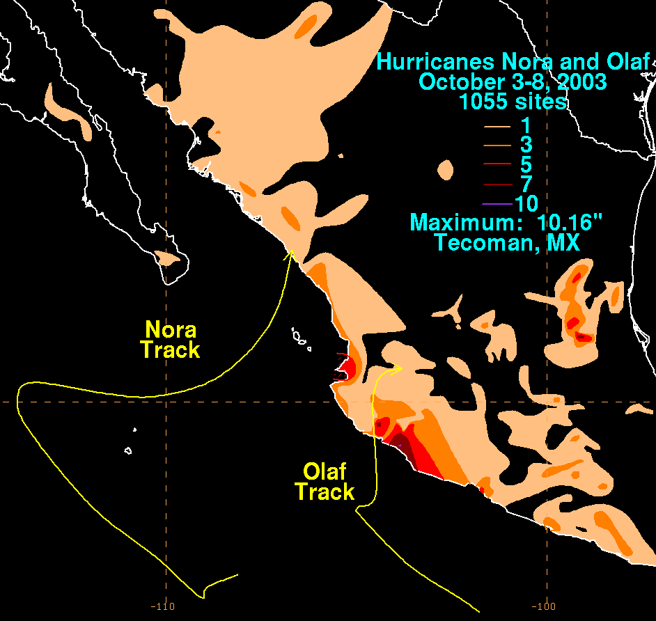
, or Mexico's National Weather Service, issued 46 advisories and 16 caution bulletins on the storm. As the storm moved parallel to the Mexican coastline, it produced high waves. Later, when Nora moved ashore in Sinaloa, it dropped locally heavy rainfall. The peak 24 hour total was 3.75 in (95.3 mm) in Mazatlán, Sinaloa, recorded on October 8. The rainfall maximum for the previous day was 3.43 in (87.0 mm) in Gaviotas, Nayarit
. Rainfall from Nora extended was also reported along the Baja California peninsula, and also extended from the coastline northward to near Texas. Its impact was minimal in western Mexico, and there were no reports of damage, deaths, or injuries.
Moisture from the remnants of Nora and Olaf interacted with an upper-level low to produce heavy rainfall across Texas, producing flooding near Waco
that forced a family to evacuate in McGregor
. The floodwaters closed portions of Interstate 35
, U.S. Route 84
, and Texas State Highway 36. The system also spawned a tornado in Sugar Land
that damaged four buildings, including a school.
Nora was the final Pacific storm of the season to strike Mexico. The others were hurricanes Ignacio
and Marty
, and tropical storms Carlos
and Olaf.
Tropical cyclone
A tropical cyclone is a storm system characterized by a large low-pressure center and numerous thunderstorms that produce strong winds and heavy rain. Tropical cyclones strengthen when water evaporated from the ocean is released as the saturated air rises, resulting in condensation of water vapor...
s to make landfall
Landfall (meteorology)
Landfall is the event of a tropical cyclone or a waterspout coming onto land after being over water. When a waterspout makes landfall it is reclassified as a tornado, which can then cause damage inland...
in the 2003 Pacific hurricane season
2003 Pacific hurricane season
The 2003 Pacific hurricane season produced an unusually large number of tropical cyclones which affected Mexico. The most notable cyclones the year were Hurricanes Ignacio and Marty, which killed 2 and 12 people in Mexico, respectively, and were collectively responsible for about...
. The fourteenth named storm
Tropical cyclone naming
Tropical cyclones have officially been named since 1945 and are named for a variety of reasons, which include to facilitate communications between forecasters and the public when forecasts, watches, and warnings are issued. Names also reduce confusion about what storm is being described, as more...
and fifth hurricane of the season, Nora developed on October 1 from a tropical wave
Tropical wave
Tropical waves, easterly waves, or tropical easterly waves, also known as African easterly waves in the Atlantic region, are a type of atmospheric trough, an elongated area of relatively low air pressure, oriented north to south, which move from east to west across the tropics causing areas of...
. It slowly intensified as it moved northwestward, intensifying into a hurricane on October 4. That day, Nora rapidly intensified to its peak of 100 mph (160 km/h), but the larger Hurricane Olaf
Hurricane Olaf (2003)
Hurricane Olaf was a weak hurricane that impacted Mexico. A tropical wave became better organized on October 2 to the south-southeast of Acapulco and developed into a depression the next day. It strengthened into Tropical Storm Olaf six hours after forming...
to its east prevented further strengthening. An approaching trough
Trough (meteorology)
A trough is an elongated region of relatively low atmospheric pressure, often associated with fronts.Unlike fronts, there is not a universal symbol for a trough on a weather chart. The weather charts in some countries or regions mark troughs by a line. In the United States, a trough may be marked...
turned the rapidly weakening system to the east toward Mexico. By October 7, it was downgraded to a tropical depression. Although it no longer met the criteria for being a tropical cyclone, the National Hurricane Center
National Hurricane Center
The National Hurricane Center , located at Florida International University in Miami, Florida, is the division of the National Weather Service responsible for tracking and predicting weather systems within the tropics between the Prime Meridian and the 140th meridian west poleward to the 30th...
continued issuing advisories due to the cyclone's proximity with land. Nora unexpectedly redeveloped an area of thunderstorms and moved ashore near Mazatlán
Mazatlán
Mazatlán is a city in the Mexican state of Sinaloa; the surrounding municipio for which the city serves as the municipal seat is Mazatlán Municipality. It is located at on the Pacific coast, across from the southernmost tip of the Baja California peninsula.Mazatlán is a Nahuatl word meaning...
, Sinaloa
Sinaloa
Sinaloa officially Estado Libre y Soberano de Sinaloa is one of the 31 states which, with the Federal District, comprise the 32 Federal Entities of Mexico. It is divided in 18 municipalities and its capital city is Culiacán Rosales....
on October 9 before dissipating. The depression dropped locally heavy rainfall in western Mexico, but there were no reports of damage. Later, the remnants combined with Olaf and an upper-level low
Cold-core low
A cold-core low, also known as a cold low or cold-core cyclone, is a cyclone aloft which has an associated cold pool of air residing at high altitude within the Earth's troposphere. It is a low pressure system which strengthens with height in accordance with the thermal wind relationship. These...
to produce flooding and a tornado in central Texas.
Meteorological history
The origins of Nora were from a tropical wave that exited the west coast of Africa on September 13. It moved westward across the Atlantic Ocean and Caribbean Sea without developing. The wave axis crossed Central America on September 25, with its convection tracking westward along the southern Mexican coastline. On September 29, the system became better organized when it reached a position about 100 mi (160 km) south of AcapulcoAcapulco
Acapulco is a city, municipality and major sea port in the state of Guerrero on the Pacific coast of Mexico, southwest from Mexico City. Acapulco is located on a deep, semi-circular bay and has been a port since the early colonial period of Mexico’s history...
. Although upper-level wind shear
Wind shear
Wind shear, sometimes referred to as windshear or wind gradient, is a difference in wind speed and direction over a relatively short distance in the atmosphere...
was only marginally favorable, the National Hurricane Center first noted the potential for tropical cyclogenesis
Tropical cyclogenesis
Tropical cyclogenesis is the term that describes the development and strengthening of a tropical cyclone in the atmosphere. The mechanisms through which tropical cyclogenesis occurs are distinctly different from those through which mid-latitude cyclogenesis occurs...
on September 30 over the subsequent few days. This verified on October 1 after the thunderstorms organized enough for the system to be classified as Tropical Depression Fourteen-E. At the time, it was located about 600 mi (975 km) south of the southern tip of the Baja California peninsula
Baja California Peninsula
The Baja California peninsula , is a peninsula in northwestern Mexico. Its land mass separates the Pacific Ocean from the Gulf of California. The Peninsula extends from Mexicali, Baja California in the north to Cabo San Lucas, Baja California Sur in the south.The total area of the Baja California...
.
Upon developing, the depression had a well-defined low-level circulation
Atmospheric circulation
Atmospheric circulation is the large-scale movement of air, and the means by which thermal energy is distributed on the surface of the Earth....
, and with a ridge
Ridge (meteorology)
A ridge is an elongated region of relatively high atmospheric pressure, the opposite of a trough....
to the north, it moved south of due west. Conditions favored further development, including low wind shear and warm water temperatures. The convection gradually organized, and the depression intensified into Tropical Storm Nora early on October 2. Its motion briefly became nearly stationary as Nora rounded the furthest extent of the ridge, although a steady motion to the northwest began on October 3. That day, an eye feature
Eye (cyclone)
The eye is a region of mostly calm weather found at the center of strong tropical cyclones. The eye of a storm is a roughly circular area and typically 30–65 km in diameter. It is surrounded by the eyewall, a ring of towering thunderstorms where the second most severe weather of a cyclone...
developed in the center of the deep convection, and Nora attained hurricane status early on October 4. Steady intensification continued to winds of 100 mph (160 km/h) by later that day, and favorable conditions were expected to allow the hurricane to reach major hurricane status, or winds of 115 mph (185 km/h). However, Nora did not intensify further, due to unfavorable increased wind shear from the developing Tropical Storm Olaf
Hurricane Olaf (2003)
Hurricane Olaf was a weak hurricane that impacted Mexico. A tropical wave became better organized on October 2 to the south-southeast of Acapulco and developed into a depression the next day. It strengthened into Tropical Storm Olaf six hours after forming...
to its east.
By October 5, the eye of Nora was no longer evident on satellite imagery, which indicated the beginning of a weakening trend. However, a Special Sensor Microwave/Imager
Special Sensor Microwave/Imager
The special sensor microwave/imager is a seven-channel, four-frequency, linearly polarized passive microwave radiometer system. It is flown on board the United States Air Force Defense Meteorological Satellite Program Block 5D-2 satellites. The instrument measures surface/atmospheric microwave...
observed a small eye that was open to the northwest. The convection became ragged, and on October 6 the winds decreased below hurricane-force. Around the same time, a strong approaching mid-level trough
Trough (meteorology)
A trough is an elongated region of relatively low atmospheric pressure, often associated with fronts.Unlike fronts, there is not a universal symbol for a trough on a weather chart. The weather charts in some countries or regions mark troughs by a line. In the United States, a trough may be marked...
caused Nora to slow and turn to the east. Continued wind shear and the presence of dry air stripped the thunderstorms away from the center, and by October 7 all of the deep convection had dissipated. As a result, it was downgraded to a tropical depression, and Nora weakened to the extent that it barely met the criteria for being a tropical cyclone. The NHC maintained advisories due to the circulation's proximity to western Mexico, as well as the unlikely potential for redeveloping thunderstorms due to its movement over warmer waters. Nora accelerated to the east-northeast and later to the northeast due to the advancing trough. As it approached western Mexico, an area of curved convection unexpectedly developed over the center. Without additional redevelopment, the poorly-defined circulation of Nora made landfall
Landfall (meteorology)
Landfall is the event of a tropical cyclone or a waterspout coming onto land after being over water. When a waterspout makes landfall it is reclassified as a tornado, which can then cause damage inland...
near Mazatlán, Sinaloa early on October 9. It dissipated shortly thereafter over the high terrain of western Mexico.
Preparations and impact
Tropical cyclone warnings and watches
Warnings and watches are two levels of alert issued by national weather forecasting bodies to coastal areas threatened by the imminent approach of a tropical cyclone of tropical storm or hurricane intensity. They are notices to the local population and civil authorities to make appropriate...
. However, the Servicio Meteorológico Nacional
Servicio Meteorológico Nacional
The Servicio Meteorológico Nacional is Mexico's national weather organization. It collects data and issues forecasts, advisories, and warnings for the entire country.-History:...
, or Mexico's National Weather Service, issued 46 advisories and 16 caution bulletins on the storm. As the storm moved parallel to the Mexican coastline, it produced high waves. Later, when Nora moved ashore in Sinaloa, it dropped locally heavy rainfall. The peak 24 hour total was 3.75 in (95.3 mm) in Mazatlán, Sinaloa, recorded on October 8. The rainfall maximum for the previous day was 3.43 in (87.0 mm) in Gaviotas, Nayarit
Nayarit
Nayarit officially Estado Libre y Soberano de Nayarit is one of the 31 states which, with the Federal District, comprise the 32 Federal Entities of Mexico. It is divided in 20 municipalities and its capital city is Tepic.It is located in Western Mexico...
. Rainfall from Nora extended was also reported along the Baja California peninsula, and also extended from the coastline northward to near Texas. Its impact was minimal in western Mexico, and there were no reports of damage, deaths, or injuries.
Moisture from the remnants of Nora and Olaf interacted with an upper-level low to produce heavy rainfall across Texas, producing flooding near Waco
Waco, Texas
Waco is a city in and the county seat of McLennan County, Texas. Situated along the Brazos River and on the I-35 corridor, halfway between Dallas and Austin, it is the economic, cultural, and academic center of the 'Heart of Texas' region....
that forced a family to evacuate in McGregor
McGregor, Texas
McGregor is a city in Coryell and McLennan Counties in the U.S. state of Texas. The population was 4,727 at the 2000 census.McGregor lies in two counties as well as two metropolitan areas...
. The floodwaters closed portions of Interstate 35
Interstate 35 in Texas
Interstate 35 in Texas is a major north–south Interstate Highway running from Laredo near the United States-Mexico border to the Red River north of Gainesville where it crosses into Oklahoma. Along its route, it passes through the cities of San Antonio, Austin, and Waco before it splits into two...
, U.S. Route 84
U.S. Route 84
U.S. Route 84 is an east–west United States highway. It started as a short Georgia-Alabama route in the original 1926 scheme, but now extends all the way to Colorado. The highway's eastern terminus is a short distance east of Midway, Georgia, at an intersection with I-95. The road continues...
, and Texas State Highway 36. The system also spawned a tornado in Sugar Land
Sugar Land, Texas
Sugar Land is a city in the U.S. state of Texas within the metropolitan area and Fort Bend County. Sugar Land is one of the most affluent and fastest-growing cities in Texas, having grown more than 158 percent in the last decade. In the time period of 2000–2007, Sugar Land also enjoyed a...
that damaged four buildings, including a school.
Nora was the final Pacific storm of the season to strike Mexico. The others were hurricanes Ignacio
Hurricane Ignacio (2003)
Hurricane Ignacio was the latest-forming first hurricane of a Pacific hurricane season since reliable satellite observation began in 1966. The ninth tropical storm of the 2003 Pacific hurricane season, Ignacio developed out of a tropical wave on August 22 a short distance off the coast of Mexico...
and Marty
Hurricane Marty (2003)
Hurricane Marty was the deadliest tropical cyclone of the 2003 Pacific hurricane season. Forming on September 18, it became the 13th tropical storm and fourth hurricane of the year...
, and tropical storms Carlos
Tropical Storm Carlos (2003)
Tropical Storm Carlos was the first of five tropical cyclones to make landfall during the 2003 Pacific hurricane season. It formed on June 26 from a tropical wave to the south of Mexico. It quickly strengthened as it approached the coast, and early on June 27 Carlos moved ashore in Oaxaca...
and Olaf.
See also
- Other tropical cyclones named Nora