

Hurricane Olaf (2003)
Encyclopedia
Hurricane Olaf was a weak hurricane that impacted Mexico. A tropical wave became better organized on October 2 to the south-southeast of Acapulco
and developed into a depression the next day. It strengthened into Tropical Storm Olaf six hours after forming. Continued intensification occurred, and Olaf reached its peak strength as a Category 1 hurricane with 75 mph (120 km/h) winds on October 5 and developed a partial eyewall. The storm soon became disorganized and was only a hurricane for six hours, before re-curving towards the Mexican coast. The cyclone made landfall near Manzanillo, Colima
, on October 7 and soon dissipated overland. The storm caused severe flooding in the states of Jalisco
and Guanajuato
. However, no fatalities were reported.
. This circulation quickly became better defined over the next several hours while located 400 miles (645 km) south of Acapulco
, Mexico. The next day, Dvorak Classifications, a tool that estimates a tropical cyclone intensity, were placed at 1.5. This is equivalent to winds of around 30 mph (50 km/h). In addition, a ship nearby reported winds of 35 mph (45 km/h). Microwave imagery also indicated that the center was near the associated convection. Based on this, the system was upgraded into a tropical depression.
Initially, wind shear from nearby Tropical Storm Nora
was expect to weaken the system. However, the depression was soon upgraded into a tropical storm. Moving northwest, it steadily intensified into a moderate tropical storm late on October 3. The next day, Olaf weakened slightly; it soon intensified into a strong tropical storm roughly 24 hours later. At that time, it was noted that additional intensification was likely. On October 5, radar imagery indicated a partial eyewall
. Based on this, Olaf was upgraded into a minimal Category 1 hurricane. It reached it peak intensity at 75 mph (120 km/h) and a barometric pressure of 987 millibars
. Olaf was hurricane for only six hours, but operationally it was believed had been a hurricane for much longer. This is because that the center was initially believed to be further north, closer to the deep convection.
Shortly after reaching its peak, Olaf became disorganized. Olaf weakened steadily while the storms motion slowed down. By early October 6, Olaf was only a minimal tropical storm as the system recurved northwest. However, Olaf rapidly reorganized that afternoon and the National Hurricane Center
re-assessed the intensity at 50 mph (80 km/h). Continued restrengthening occurred, and by October 8 Olaf made landfall wind winds of 60 mph (98 km/h) near Manzanillo
, Mexico. Shortly thereafter, Olaf weakened rapidly over the high terrain of the coast. Within 24 hours, Olaf had dissipated inland.
 While Olaf was at peak strength, a tropical storm warning issued for Punta San Telmo to Lazaro Cardenas and a hurricane warning was issued from Punta San Telmo to San Blasincluding the Islas Marias. The next day, the tropical storm warning was extend to include Manzanillo
. At that same time, a hurricane watch was issued from San Blas to Mazatlán. In addition, hurricane warning was extend to include areas from Manzanillo to San Blas including the Islas Marias. Thee hours later, when Olaf was revealed to be much weaker, the hurricane warnings and hurricane watches were canceled. However, the tropical storm warnings remained in effect until October 7. A yellow alert was declared in Mexican states Michoacán
, Colima
, and Jalisco
, and green alert was declared in Baja California Sur
, Sinaloa
, Nayarit
, and Guerrero
. Local authorities also opened shelters.
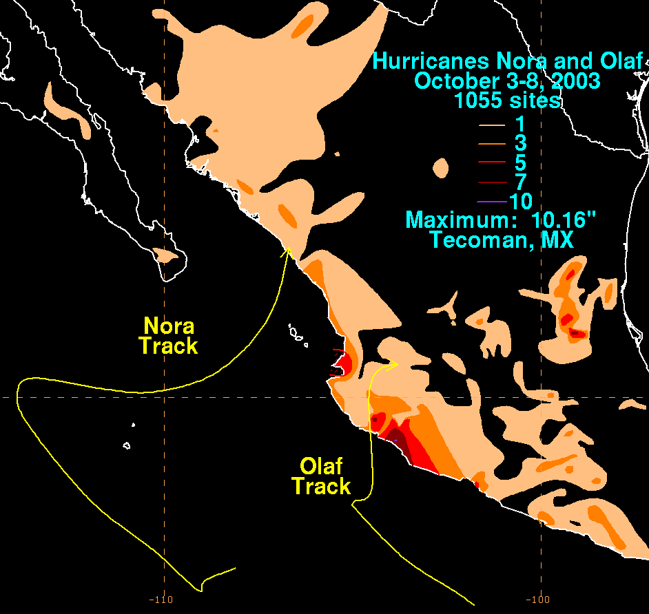
Olaf was a part of a rainy year in Mexico, producing more rain than Hurricane Nora
. Although no deaths were reported, flooding caused serve damage to roadways and crops in the Mexican state of Jalisco. In the same state, more than 12,000 homes were damaged. In state of Guanajuato
, an estimated total of 15,000 people were impact from the floods. In addition, two communities were isolated. After the hurricane, a program wanted donation from food to basic home supplies. Moisture from the remnants of Nora and Olaf interacted with an upper-level low to produce heavy rainfall across Texas, producing flooding near Waco
that forced a family to evacuate in McGregor
. The floodwaters closed portions of Interstate 35
, U.S. Route 84
, and Texas State Highway 36. It also spawned a tornado in Sugar Land
that damaged four buildings, including a school.
Acapulco
Acapulco is a city, municipality and major sea port in the state of Guerrero on the Pacific coast of Mexico, southwest from Mexico City. Acapulco is located on a deep, semi-circular bay and has been a port since the early colonial period of Mexico’s history...
and developed into a depression the next day. It strengthened into Tropical Storm Olaf six hours after forming. Continued intensification occurred, and Olaf reached its peak strength as a Category 1 hurricane with 75 mph (120 km/h) winds on October 5 and developed a partial eyewall. The storm soon became disorganized and was only a hurricane for six hours, before re-curving towards the Mexican coast. The cyclone made landfall near Manzanillo, Colima
Manzanillo, Colima
The name Manzanillo refers to the city as well as its surrounding municipality in the Mexican state of Colima. The city, located on the Pacific Ocean, contains Mexico's busiest port. Manzanillo was the third port created by the Spanish in the Pacific during the New Spain period...
, on October 7 and soon dissipated overland. The storm caused severe flooding in the states of Jalisco
Jalisco
Jalisco officially Estado Libre y Soberano de Jalisco is one of the 31 states which, with the Federal District, comprise the 32 Federal Entities of Mexico. It is located in Western Mexico and divided in 125 municipalities and its capital city is Guadalajara.It is one of the more important states...
and Guanajuato
Guanajuato
Guanajuato officially Estado Libre y Soberano de Guanajuato is one of the 31 states which, with the Federal District, comprise the 32 Federal Entities of Mexico. It is divided in 46 municipalities and its capital city is Guanajuato....
. However, no fatalities were reported.
Meteorological history
Olaf formed from a tropical wave that left the coast of Africa on September 17. Over the next two weeks it moved westbound into the East Pacific Ocean. Initially, the wave was not in an environment conductive for further development. However, on October 2, a low-level circulation was noted on satellite imagerySatellite imagery
Satellite imagery consists of photographs of Earth or other planets made by means of artificial satellites.- History :The first images from space were taken on sub-orbital flights. The U.S-launched V-2 flight on October 24, 1946 took one image every 1.5 seconds...
. This circulation quickly became better defined over the next several hours while located 400 miles (645 km) south of Acapulco
Acapulco
Acapulco is a city, municipality and major sea port in the state of Guerrero on the Pacific coast of Mexico, southwest from Mexico City. Acapulco is located on a deep, semi-circular bay and has been a port since the early colonial period of Mexico’s history...
, Mexico. The next day, Dvorak Classifications, a tool that estimates a tropical cyclone intensity, were placed at 1.5. This is equivalent to winds of around 30 mph (50 km/h). In addition, a ship nearby reported winds of 35 mph (45 km/h). Microwave imagery also indicated that the center was near the associated convection. Based on this, the system was upgraded into a tropical depression.
Initially, wind shear from nearby Tropical Storm Nora
Hurricane Nora (2003)
Hurricane Nora was the final of five tropical cyclones to make landfall in the 2003 Pacific hurricane season. The fourteenth named storm and fifth hurricane of the season, Nora developed on October 1 from a tropical wave. It slowly intensified as it moved northwestward, intensifying into a...
was expect to weaken the system. However, the depression was soon upgraded into a tropical storm. Moving northwest, it steadily intensified into a moderate tropical storm late on October 3. The next day, Olaf weakened slightly; it soon intensified into a strong tropical storm roughly 24 hours later. At that time, it was noted that additional intensification was likely. On October 5, radar imagery indicated a partial eyewall
Eye (cyclone)
The eye is a region of mostly calm weather found at the center of strong tropical cyclones. The eye of a storm is a roughly circular area and typically 30–65 km in diameter. It is surrounded by the eyewall, a ring of towering thunderstorms where the second most severe weather of a cyclone...
. Based on this, Olaf was upgraded into a minimal Category 1 hurricane. It reached it peak intensity at 75 mph (120 km/h) and a barometric pressure of 987 millibars
Bar (unit)
The bar is a unit of pressure equal to 100 kilopascals, and roughly equal to the atmospheric pressure on Earth at sea level. Other units derived from the bar are the megabar , kilobar , decibar , centibar , and millibar...
. Olaf was hurricane for only six hours, but operationally it was believed had been a hurricane for much longer. This is because that the center was initially believed to be further north, closer to the deep convection.
Shortly after reaching its peak, Olaf became disorganized. Olaf weakened steadily while the storms motion slowed down. By early October 6, Olaf was only a minimal tropical storm as the system recurved northwest. However, Olaf rapidly reorganized that afternoon and the National Hurricane Center
National Hurricane Center
The National Hurricane Center , located at Florida International University in Miami, Florida, is the division of the National Weather Service responsible for tracking and predicting weather systems within the tropics between the Prime Meridian and the 140th meridian west poleward to the 30th...
re-assessed the intensity at 50 mph (80 km/h). Continued restrengthening occurred, and by October 8 Olaf made landfall wind winds of 60 mph (98 km/h) near Manzanillo
Manzanillo, Colima
The name Manzanillo refers to the city as well as its surrounding municipality in the Mexican state of Colima. The city, located on the Pacific Ocean, contains Mexico's busiest port. Manzanillo was the third port created by the Spanish in the Pacific during the New Spain period...
, Mexico. Shortly thereafter, Olaf weakened rapidly over the high terrain of the coast. Within 24 hours, Olaf had dissipated inland.
Preparations and Impact
Manzanillo, Colima
The name Manzanillo refers to the city as well as its surrounding municipality in the Mexican state of Colima. The city, located on the Pacific Ocean, contains Mexico's busiest port. Manzanillo was the third port created by the Spanish in the Pacific during the New Spain period...
. At that same time, a hurricane watch was issued from San Blas to Mazatlán. In addition, hurricane warning was extend to include areas from Manzanillo to San Blas including the Islas Marias. Thee hours later, when Olaf was revealed to be much weaker, the hurricane warnings and hurricane watches were canceled. However, the tropical storm warnings remained in effect until October 7. A yellow alert was declared in Mexican states Michoacán
Michoacán
Michoacán officially Estado Libre y Soberano de Michoacán de Ocampo is one of the 31 states which, with the Federal District, comprise the 32 Federal Entities of Mexico. It is divided in 113 municipalities and its capital city is Morelia...
, Colima
Colima
Colima is one of the 31 states which, with the Federal District, make up the 32 Federal Entities of Mexico. It shares its name with its capital and main city, Colima....
, and Jalisco
Jalisco
Jalisco officially Estado Libre y Soberano de Jalisco is one of the 31 states which, with the Federal District, comprise the 32 Federal Entities of Mexico. It is located in Western Mexico and divided in 125 municipalities and its capital city is Guadalajara.It is one of the more important states...
, and green alert was declared in Baja California Sur
Baja California Sur
Baja California Sur , is one of the 31 states which, with the Federal District, comprise the 32 Federal Entities of Mexico. Before becoming a state on October 8, 1974, the area was known as the South Territory of Baja California. It has an area of , or 3.57% of the land mass of Mexico and comprises...
, Sinaloa
Sinaloa
Sinaloa officially Estado Libre y Soberano de Sinaloa is one of the 31 states which, with the Federal District, comprise the 32 Federal Entities of Mexico. It is divided in 18 municipalities and its capital city is Culiacán Rosales....
, Nayarit
Nayarit
Nayarit officially Estado Libre y Soberano de Nayarit is one of the 31 states which, with the Federal District, comprise the 32 Federal Entities of Mexico. It is divided in 20 municipalities and its capital city is Tepic.It is located in Western Mexico...
, and Guerrero
Guerrero
Guerrero officially Estado Libre y Soberano de Guerrero is one of the 31 states which, with the Federal District, comprise the 32 Federal Entities of Mexico. It is divided in 81 municipalities and its capital city is Chilpancingo....
. Local authorities also opened shelters.
Olaf was a part of a rainy year in Mexico, producing more rain than Hurricane Nora
Hurricane Nora (2003)
Hurricane Nora was the final of five tropical cyclones to make landfall in the 2003 Pacific hurricane season. The fourteenth named storm and fifth hurricane of the season, Nora developed on October 1 from a tropical wave. It slowly intensified as it moved northwestward, intensifying into a...
. Although no deaths were reported, flooding caused serve damage to roadways and crops in the Mexican state of Jalisco. In the same state, more than 12,000 homes were damaged. In state of Guanajuato
Guanajuato
Guanajuato officially Estado Libre y Soberano de Guanajuato is one of the 31 states which, with the Federal District, comprise the 32 Federal Entities of Mexico. It is divided in 46 municipalities and its capital city is Guanajuato....
, an estimated total of 15,000 people were impact from the floods. In addition, two communities were isolated. After the hurricane, a program wanted donation from food to basic home supplies. Moisture from the remnants of Nora and Olaf interacted with an upper-level low to produce heavy rainfall across Texas, producing flooding near Waco
Waco, Texas
Waco is a city in and the county seat of McLennan County, Texas. Situated along the Brazos River and on the I-35 corridor, halfway between Dallas and Austin, it is the economic, cultural, and academic center of the 'Heart of Texas' region....
that forced a family to evacuate in McGregor
McGregor, Texas
McGregor is a city in Coryell and McLennan Counties in the U.S. state of Texas. The population was 4,727 at the 2000 census.McGregor lies in two counties as well as two metropolitan areas...
. The floodwaters closed portions of Interstate 35
Interstate 35 in Texas
Interstate 35 in Texas is a major north–south Interstate Highway running from Laredo near the United States-Mexico border to the Red River north of Gainesville where it crosses into Oklahoma. Along its route, it passes through the cities of San Antonio, Austin, and Waco before it splits into two...
, U.S. Route 84
U.S. Route 84
U.S. Route 84 is an east–west United States highway. It started as a short Georgia-Alabama route in the original 1926 scheme, but now extends all the way to Colorado. The highway's eastern terminus is a short distance east of Midway, Georgia, at an intersection with I-95. The road continues...
, and Texas State Highway 36. It also spawned a tornado in Sugar Land
Sugar Land, Texas
Sugar Land is a city in the U.S. state of Texas within the metropolitan area and Fort Bend County. Sugar Land is one of the most affluent and fastest-growing cities in Texas, having grown more than 158 percent in the last decade. In the time period of 2000–2007, Sugar Land also enjoyed a...
that damaged four buildings, including a school.