
Hurricane Keith
Encyclopedia
Hurricane Keith caused extensive damage in Central America
, especially in Mexico
and Belize
. The fifteenth tropical cyclone
, eleventh named storm, and seventh hurricane of the 2000 Atlantic hurricane season
, Keith developed as a tropical depression from a tropical wave
in the western Caribbean Sea
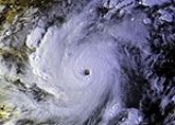
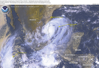
on September 28. The depression gradually strengthened, and became Tropical Storm Keith on the following day. As the storm tracked westward, it continued to intensify and was upgraded to a hurricane on September 30. Shortly thereafter, Keith began to rapidly deepen
, and peaked as a Category 4 hurricane less than 24 hours later. Keith then began to meander erratically offshore of Belize, which significantly weakened the storm due to land interaction. By late on October 2, Keith made landfall in Ambergris Caye
, Belize as a minimal hurricane. It weakened quickly weakened to a tropical storm, before another landfall occurred near Belize City
early on the following day. While moving inland over the Yucatán Peninsula
, Keith weakened further, and was downgraded to a tropical depression before emerging into the Gulf of Mexico
on October 4. Once in the Gulf of Mexico, Keith began to re-strengthen and was upgraded to a tropical storm later that day, and a hurricane on the following day. By late on October 5, Keith made its third and final landfall near Tampico, Tamaulipas, Mexico as a moderately strong Category 1 hurricane. The storm quickly weakened inland and dissipated as a tropical cyclone by 24 hours after landfall.
Keith brought heavy rainfall to several countries in Central America, which resulted in extensive flooding, especially in Belize and Mexico. In Guatemala
, the storm flooded 10 towns, and caused one fatality. Similarly, one fatality also occurred in El Salvador
, and at least 300 people were affected by flooding in that country. Thirteen communities in Nicaragua
were completely isolated after Keith made roads impassable. Twelve deaths were reported in Nicaragua, all of which were flood-related. Five people were presumed dead in Honduras
after an aircraft disappeared near Roatán
; one other fatality occurred due to flooding. The storm brought torrential rainfall to Belize, with many areas reporting at least 10 inches (254 mm) of rain, while highest reported amount of precipitation was greater than 30 inches (762 mm). In Belize, a village reported that only 12 houses remained, while elsewhere in the country, at least 60 homes were destroyed or damaged; several houses in Belize City
suffered minor roof damage. At least 19 people were killed in Belize and damages totaled to $280 million (2000 USD
). Heavy rainfall also occurred in Mexico, especially in the states of Nuevo León
and Tamaulipas
. Flooding from Keith caused several mudslides and a few rivers reached historic levels. Throughout Mexico, at least 460 houses were damage or destroyed and other losses in infrastructure occurred. In addition, one person drowned due to heavy rainfall. Damages incurred in associated with Keith in Mexico totaled to approximately $365.9 million (2000 MXN, $38.7 million 2000 USD). Overall, Keith was responsible for 40 deaths and $319 million (2000 USD) in damage.
, upper level winds became much more favorable, and the wave developed into Tropical Depression Fifteen on September 28, 60 mi (96.6 km) northeast of Cape Gracias a Dios, Nicaragua
. The newly-formed tropical cyclone drifted northwestward, and became Tropical Storm Keith on September 29.
 Conditions became nearly ideal for Keith's development on September 30, with little to no shear, a well-developed anticyclone over it, and warm Caribbean water temperatures
allowing for the storm to strengthen. Keith became a hurricane on September 30, which was followed by rapid intensification to a 140 mph (225 km/h) Category 4 hurricane only 18 hours later. As it neared the Belize
coast, high pressure blocked further westward progress, leading Keith to execute a small loop just off the coast. Land interaction weakened the hurricane to a strong tropical storm by the time it made its first landfall on October 3. Keith became disorganized over the Yucatán
, but reintensified when it reached the Gulf of Mexico on October 4. The storm was able to intensify to a 90 mi/h hurricane before making its final landfall near Tampico, Mexico on October 5. Keith dissipated over northeastern Mexico
the next day.
, the authorities evacuated the entire city of 10,000 people to numerous shelters in Orange Walk
. Nicaragua
also had officials evacuate more than 300 people from low-lying areas.
In Mexico, 5,000 people from Chetumal and surrounding low-lying areas were forced to evacuate, and after the storm's second landfall, another 5,000 were forced evacuated from several municipalities in Nuevo León
, with 2,465 from Monterrey
, and 1,900 from rural areas, with a cost of $400,000 (2000 MXN).
Keith was a very difficult hurricane to forecast. Its strength extremes and its stalling offshore Belize caused many problems to forecasters. This led to a deadly situation of waiting for the storm to finally recede.
Keith caused massive flooding over Belize and Mexico, as well as road destruction and landslides. The storm caused 40 direct deaths and an unknown amount of indirect deaths.
, at only 4–5 feet. The National Hurricane Center
also received reports of the water in the Bay of Chetumal was temporarily blown out of the bay by northerly winds from Keith. Several people walked onto the exposed ocean floor, not realizing that the water could return at any moment. Nobody was injured or killed while on the ocean bottom.
Belize City
was buried under four feet of water and lost water supply and electricity. Some of the downed power lines sent sparks into the open, forcing most people to remain in their homes after the storm until the live wires were fixed or removed. Twenty homes were damaged to some degree in the capital, while many more suffered minor roof damage. 40 homes in Caye Caulker were destroyed, while the remaining buildings lost phone connection and electricity in Caye Caulker and San Pedro, Belize. The lagoon area of San Pedro received the worst damage in the city. The local Texaco
station was completely demolished. San Juan was spared, but the village of San Pedrito was significantly affected by Keith. Only twelve houses were reported to have stood up to the storm's wrath. The rest were flattened.
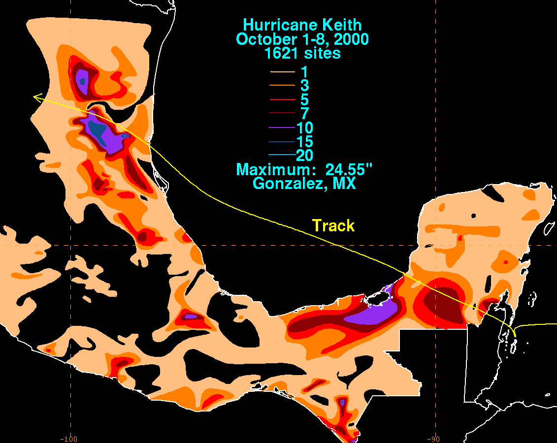
Several areas in Belize received up to 10 inches (254 mm) of rain, but the Philip S. W. Goldson International Airport
in Belize City reported a total of 32.67 inches (829.8 mm).
The five Belizean deaths occurred after two catamarans broke loose from what was holding them. An additional 14 people perished, likely due to flooding. Several injuries, mainly from flying debris, were reported in San Pedro
, but fortunately, no fatalities. The major hurricane caused an estimated $280 million (2000 USD, $399 million 2008 USD) in damage in Belize.
In Nuevo León
, near Monterrey
, Keith caused torrential rainfall, with the average precipitation on the state being 5 in (120 mm), causing mudslides on several cities, including San Pedro, Guadalupe and Escobedo. The swift currents, caused by the flash flood
after the storm, rose up to 9,000 ft³/s (250 m³/s), and dragged 130 people into local rivers; however, all were rescued. The rivers also dragged 30 vehicles, all of which were moderate to total losses. The storm runoff caused the El Cuchillo dam to receive 105000 acre.ft of water daily, and the La Boca dam to receive 810 acre.ft per hour. 13,000 residents also lost power. The total damages in the state rose to $115.6 million (2000 MXN
, $12.2 million 2000 USD
), with the damage to urban infrastructure being the most expensive portion of the damage, with $44.2 million (2000 MXN, $4.6 million 2000 USD) used to repair damage in eight municipalities; in particular, San Pedro Garza García
received approximately three quarters of the infrastructure damage, with $30.8 million (2000 MXN, $3.3 million 2000 USD). Additionally, about 460 homes were damaged or destroyed, and 300 families had to be relocated to safer areas.
 In Tamaulipas
, the storm caused as much, if not more rainfall than in Nuevo León. In a reporting station in the municipality of Gómez Farías
, the pluviometer reported a 24-hour rain total of 13.24 in (336.5 mm), and a storm total of 18.44 in (468.5 mm), which broke the precipitation record for that location, which counted with 35 years of data. This rain also caused rivers to reach record levels, as the Sabinas River rose 10.95 m (35.93 ft) on October 6, to a new historical peak, and the Guayalejo River rose 77.46 ft (23.61 m), slightly under the 1976 record. This rainfall caused the Las Ánimas dam to catch 525000 acre.ft of water between October 5 and October 17; however, some of this water had to be released, as the upstream face of the dam was damaged by debris, and had to be repaired. Overall, the storm produced $117.8 million in damage (2000 MXN, $12.4 million 2000 USD) in the state.
In other states, damage was lighter, but still significant. In Sonora
, total damages rose to $64.4 million (2000 MXN, $6.8 million 2000 USD); in Quintana Roo
, $42.2 million (2000 MXN, $4.5 million 2000 USD) were incurred, and in Chiapas
, $25.6 million (2000 MXN, $2.7 million 2000 USD) of property damage were caused by the storm. This brings up the total damage in Mexico to $365.9 million (2000 MXN, $38.7 million 2000 USD).
The one reported death in Mexico associated with Keith was due to flooding from heavy rains.
and San Pedro
in Belize
as soon as weather conditions permitted it. Widespread road repairs also began almost immediately after Keith's occurrence. The Belize International Airport was back online by the morning of October 4, only a single day after the severe tropical cyclone passed through the area. A donation account to help the relief effort, titled Hurricane Keith Relief Fund, was set up by the town of Placencia, in the local Atlantic Bank. The Belize Consulate in California
also set up a donation fundraiser. Placencia also delivered a boat full of donated food, clothing, and building supplies to the San Pedro and Caye Caulker area.
United Nations Development Programme
received $30,000 (2000 USD, $38,000 2008 USD) from the Government of Norway to give immediate relief to the country of Belize. United Nations Children's Fund
also gave out $150,000 (2000 USD, $188,000 2008 USD) for relief in areas not focused on by other relief groups.
The name Keith was retired in the spring of 2001 due to this storm, and will never again be used for an Atlantic hurricane
. The name was replaced with Kirk, but the name Kirk has yet to be used, as the 2006 Atlantic hurricane season
did not have enough storms to reach the name.
Central America
Central America is the central geographic region of the Americas. It is the southernmost, isthmian portion of the North American continent, which connects with South America on the southeast. When considered part of the unified continental model, it is considered a subcontinent...
, especially in Mexico
Mexico
The United Mexican States , commonly known as Mexico , is a federal constitutional republic in North America. It is bordered on the north by the United States; on the south and west by the Pacific Ocean; on the southeast by Guatemala, Belize, and the Caribbean Sea; and on the east by the Gulf of...
and Belize
Belize
Belize is a constitutional monarchy and the northernmost country in Central America. Belize has a diverse society, comprising many cultures and languages. Even though Kriol and Spanish are spoken among the population, Belize is the only country in Central America where English is the official...
. The fifteenth tropical cyclone
Tropical cyclone
A tropical cyclone is a storm system characterized by a large low-pressure center and numerous thunderstorms that produce strong winds and heavy rain. Tropical cyclones strengthen when water evaporated from the ocean is released as the saturated air rises, resulting in condensation of water vapor...
, eleventh named storm, and seventh hurricane of the 2000 Atlantic hurricane season
2000 Atlantic hurricane season
The 2000 Atlantic hurricane season was the first season without a tropical cyclone in July since 1987. The season officially began on June 1, 2000, and lasted until November 30, 2000. The June through November dates conventionally delimit the period of each year when most tropical cyclones form in...
, Keith developed as a tropical depression from a tropical wave
Tropical wave
Tropical waves, easterly waves, or tropical easterly waves, also known as African easterly waves in the Atlantic region, are a type of atmospheric trough, an elongated area of relatively low air pressure, oriented north to south, which move from east to west across the tropics causing areas of...
in the western Caribbean Sea
Caribbean Sea
The Caribbean Sea is a sea of the Atlantic Ocean located in the tropics of the Western hemisphere. It is bounded by Mexico and Central America to the west and southwest, to the north by the Greater Antilles, and to the east by the Lesser Antilles....
on September 28. The depression gradually strengthened, and became Tropical Storm Keith on the following day. As the storm tracked westward, it continued to intensify and was upgraded to a hurricane on September 30. Shortly thereafter, Keith began to rapidly deepen
Rapid deepening
Rapid deepening, also known as rapid intensification, is a meteorological condition that occurs when the minimum sea-level atmospheric pressure of a tropical cyclone decreases drastically in a short period of time. The National Weather Service describes rapid deepening as a decrease of...
, and peaked as a Category 4 hurricane less than 24 hours later. Keith then began to meander erratically offshore of Belize, which significantly weakened the storm due to land interaction. By late on October 2, Keith made landfall in Ambergris Caye
Ambergris Caye
Ambergris Caye, pronounced "am-BER-gris", is the largest island of Belize located northeast of the country in the Caribbean Sea. Though administered as part of the Belize District, the closest point on the mainland is part of the Corozal District....
, Belize as a minimal hurricane. It weakened quickly weakened to a tropical storm, before another landfall occurred near Belize City
Belize City
Belize City is the largest city in the Central American nation of Belize. Unofficial estimates place the population of Belize City at 70,000 or more. It is located at the mouth of the Belize River on the coast of the Caribbean. The city is the country's principal port and its financial and...
early on the following day. While moving inland over the Yucatán Peninsula
Yucatán Peninsula
The Yucatán Peninsula, in southeastern Mexico, separates the Caribbean Sea from the Gulf of Mexico, with the northern coastline on the Yucatán Channel...
, Keith weakened further, and was downgraded to a tropical depression before emerging into the Gulf of Mexico
Gulf of Mexico
The Gulf of Mexico is a partially landlocked ocean basin largely surrounded by the North American continent and the island of Cuba. It is bounded on the northeast, north and northwest by the Gulf Coast of the United States, on the southwest and south by Mexico, and on the southeast by Cuba. In...
on October 4. Once in the Gulf of Mexico, Keith began to re-strengthen and was upgraded to a tropical storm later that day, and a hurricane on the following day. By late on October 5, Keith made its third and final landfall near Tampico, Tamaulipas, Mexico as a moderately strong Category 1 hurricane. The storm quickly weakened inland and dissipated as a tropical cyclone by 24 hours after landfall.
Keith brought heavy rainfall to several countries in Central America, which resulted in extensive flooding, especially in Belize and Mexico. In Guatemala
Guatemala
Guatemala is a country in Central America bordered by Mexico to the north and west, the Pacific Ocean to the southwest, Belize to the northeast, the Caribbean to the east, and Honduras and El Salvador to the southeast...
, the storm flooded 10 towns, and caused one fatality. Similarly, one fatality also occurred in El Salvador
El Salvador
El Salvador or simply Salvador is the smallest and the most densely populated country in Central America. The country's capital city and largest city is San Salvador; Santa Ana and San Miguel are also important cultural and commercial centers in the country and in all of Central America...
, and at least 300 people were affected by flooding in that country. Thirteen communities in Nicaragua
Nicaragua
Nicaragua is the largest country in the Central American American isthmus, bordered by Honduras to the north and Costa Rica to the south. The country is situated between 11 and 14 degrees north of the Equator in the Northern Hemisphere, which places it entirely within the tropics. The Pacific Ocean...
were completely isolated after Keith made roads impassable. Twelve deaths were reported in Nicaragua, all of which were flood-related. Five people were presumed dead in Honduras
Honduras
Honduras is a republic in Central America. It was previously known as Spanish Honduras to differentiate it from British Honduras, which became the modern-day state of Belize...
after an aircraft disappeared near Roatán
Roatán
Roatán, located between the islands of Útila and Guanaja, is the largest of Honduras' Bay Islands. The island was formerly known as Ruatan and Rattan...
; one other fatality occurred due to flooding. The storm brought torrential rainfall to Belize, with many areas reporting at least 10 inches (254 mm) of rain, while highest reported amount of precipitation was greater than 30 inches (762 mm). In Belize, a village reported that only 12 houses remained, while elsewhere in the country, at least 60 homes were destroyed or damaged; several houses in Belize City
Belize City
Belize City is the largest city in the Central American nation of Belize. Unofficial estimates place the population of Belize City at 70,000 or more. It is located at the mouth of the Belize River on the coast of the Caribbean. The city is the country's principal port and its financial and...
suffered minor roof damage. At least 19 people were killed in Belize and damages totaled to $280 million (2000 USD
United States dollar
The United States dollar , also referred to as the American dollar, is the official currency of the United States of America. It is divided into 100 smaller units called cents or pennies....
). Heavy rainfall also occurred in Mexico, especially in the states of Nuevo León
Nuevo León
Nuevo León It is located in Northeastern Mexico. It is bordered by the states of Tamaulipas to the north and east, San Luis Potosí to the south, and Coahuila to the west. To the north, Nuevo León has a 15 kilometer stretch of the U.S.-Mexico border adjacent to the U.S...
and Tamaulipas
Tamaulipas
Tamaulipas officially Estado Libre y Soberano de Tamaulipas is one of the 31 states which, with the Federal District, comprise the 32 Federal Entities of Mexico. It is divided in 43 municipalities and its capital city is Ciudad Victoria. The capital city was named after Guadalupe Victoria, the...
. Flooding from Keith caused several mudslides and a few rivers reached historic levels. Throughout Mexico, at least 460 houses were damage or destroyed and other losses in infrastructure occurred. In addition, one person drowned due to heavy rainfall. Damages incurred in associated with Keith in Mexico totaled to approximately $365.9 million (2000 MXN, $38.7 million 2000 USD). Overall, Keith was responsible for 40 deaths and $319 million (2000 USD) in damage.
Meteorological history
Hurricane Keith began as a tropical wave that moved off the coast of Africa on September 16. It moved westward across the Atlantic without much development due to upper level shear. When it reached the western Caribbean SeaCaribbean Sea
The Caribbean Sea is a sea of the Atlantic Ocean located in the tropics of the Western hemisphere. It is bounded by Mexico and Central America to the west and southwest, to the north by the Greater Antilles, and to the east by the Lesser Antilles....
, upper level winds became much more favorable, and the wave developed into Tropical Depression Fifteen on September 28, 60 mi (96.6 km) northeast of Cape Gracias a Dios, Nicaragua
Nicaragua
Nicaragua is the largest country in the Central American American isthmus, bordered by Honduras to the north and Costa Rica to the south. The country is situated between 11 and 14 degrees north of the Equator in the Northern Hemisphere, which places it entirely within the tropics. The Pacific Ocean...
. The newly-formed tropical cyclone drifted northwestward, and became Tropical Storm Keith on September 29.
Sea surface temperature
Sea surface temperature is the water temperature close to the oceans surface. The exact meaning of surface varies according to the measurement method used, but it is between and below the sea surface. Air masses in the Earth's atmosphere are highly modified by sea surface temperatures within a...
allowing for the storm to strengthen. Keith became a hurricane on September 30, which was followed by rapid intensification to a 140 mph (225 km/h) Category 4 hurricane only 18 hours later. As it neared the Belize
Belize
Belize is a constitutional monarchy and the northernmost country in Central America. Belize has a diverse society, comprising many cultures and languages. Even though Kriol and Spanish are spoken among the population, Belize is the only country in Central America where English is the official...
coast, high pressure blocked further westward progress, leading Keith to execute a small loop just off the coast. Land interaction weakened the hurricane to a strong tropical storm by the time it made its first landfall on October 3. Keith became disorganized over the Yucatán
Yucatán
Yucatán officially Estado Libre y Soberano de Yucatán is one of the 31 states which, with the Federal District, comprise the 32 Federal Entities of Mexico. It is divided in 106 municipalities and its capital city is Mérida....
, but reintensified when it reached the Gulf of Mexico on October 4. The storm was able to intensify to a 90 mi/h hurricane before making its final landfall near Tampico, Mexico on October 5. Keith dissipated over northeastern Mexico
Mexico
The United Mexican States , commonly known as Mexico , is a federal constitutional republic in North America. It is bordered on the north by the United States; on the south and west by the Pacific Ocean; on the southeast by Guatemala, Belize, and the Caribbean Sea; and on the east by the Gulf of...
the next day.
Preparations
In Corozal, BelizeCorozal Town
Corozal Town is a town in the nation of Belize, capital of Corozal District. Corozal Town is located about 84 miles north of Belize City, and 9 miles from the border with Mexico. The population of Corozal Town, according to the main results of the 2010 census, it is 9,871...
, the authorities evacuated the entire city of 10,000 people to numerous shelters in Orange Walk
Orange walk
Orange walks are a series of parades held annually by members of the Orange Order during the summer in Northern Ireland, to a lesser extent in Scotland, and occasionally in England, the Republic of Ireland, and throughout the Commonwealth...
. Nicaragua
Nicaragua
Nicaragua is the largest country in the Central American American isthmus, bordered by Honduras to the north and Costa Rica to the south. The country is situated between 11 and 14 degrees north of the Equator in the Northern Hemisphere, which places it entirely within the tropics. The Pacific Ocean...
also had officials evacuate more than 300 people from low-lying areas.
In Mexico, 5,000 people from Chetumal and surrounding low-lying areas were forced to evacuate, and after the storm's second landfall, another 5,000 were forced evacuated from several municipalities in Nuevo León
Nuevo León
Nuevo León It is located in Northeastern Mexico. It is bordered by the states of Tamaulipas to the north and east, San Luis Potosí to the south, and Coahuila to the west. To the north, Nuevo León has a 15 kilometer stretch of the U.S.-Mexico border adjacent to the U.S...
, with 2,465 from Monterrey
Monterrey (municipality)
The Municipality of Monterrey is one of the 51 subdivisions of the State of Nuevo León, Mexico. Its municipal seat is located in the City of Monterrey.The municipal government is headed by the municipal president of Monterrey ....
, and 1,900 from rural areas, with a cost of $400,000 (2000 MXN).
Impact
| Region | Direct deaths |
|---|---|
| Belize Belize Belize is a constitutional monarchy and the northernmost country in Central America. Belize has a diverse society, comprising many cultures and languages. Even though Kriol and Spanish are spoken among the population, Belize is the only country in Central America where English is the official... |
19 |
| El Salvador El Salvador El Salvador or simply Salvador is the smallest and the most densely populated country in Central America. The country's capital city and largest city is San Salvador; Santa Ana and San Miguel are also important cultural and commercial centers in the country and in all of Central America... |
1 |
| Nicaragua Nicaragua Nicaragua is the largest country in the Central American American isthmus, bordered by Honduras to the north and Costa Rica to the south. The country is situated between 11 and 14 degrees north of the Equator in the Northern Hemisphere, which places it entirely within the tropics. The Pacific Ocean... |
12 |
| Honduras Honduras Honduras is a republic in Central America. It was previously known as Spanish Honduras to differentiate it from British Honduras, which became the modern-day state of Belize... |
6 |
| Guatemala Guatemala Guatemala is a country in Central America bordered by Mexico to the north and west, the Pacific Ocean to the southwest, Belize to the northeast, the Caribbean to the east, and Honduras and El Salvador to the southeast... |
1 |
| Mexico Mexico The United Mexican States , commonly known as Mexico , is a federal constitutional republic in North America. It is bordered on the north by the United States; on the south and west by the Pacific Ocean; on the southeast by Guatemala, Belize, and the Caribbean Sea; and on the east by the Gulf of... |
1 |
| Total | 40 |
Keith was a very difficult hurricane to forecast. Its strength extremes and its stalling offshore Belize caused many problems to forecasters. This led to a deadly situation of waiting for the storm to finally recede.
Keith caused massive flooding over Belize and Mexico, as well as road destruction and landslides. The storm caused 40 direct deaths and an unknown amount of indirect deaths.
Belize
While Keith was offshore Belize, it actually caused a negative surge, draining water out of various waterways. Several places were said to have a water level 4 feet (1.2 m) below average. The only actual storm surge was reported in Caye CaulkerCaye Caulker
Caye Caulker is a small limestone coral island off the coast of Belize in the Caribbean Sea measuring about by less than . The town on the island is known by the name Caye Caulker Village...
, at only 4–5 feet. The National Hurricane Center
National Hurricane Center
The National Hurricane Center , located at Florida International University in Miami, Florida, is the division of the National Weather Service responsible for tracking and predicting weather systems within the tropics between the Prime Meridian and the 140th meridian west poleward to the 30th...
also received reports of the water in the Bay of Chetumal was temporarily blown out of the bay by northerly winds from Keith. Several people walked onto the exposed ocean floor, not realizing that the water could return at any moment. Nobody was injured or killed while on the ocean bottom.
Belize City
Belize City
Belize City is the largest city in the Central American nation of Belize. Unofficial estimates place the population of Belize City at 70,000 or more. It is located at the mouth of the Belize River on the coast of the Caribbean. The city is the country's principal port and its financial and...
was buried under four feet of water and lost water supply and electricity. Some of the downed power lines sent sparks into the open, forcing most people to remain in their homes after the storm until the live wires were fixed or removed. Twenty homes were damaged to some degree in the capital, while many more suffered minor roof damage. 40 homes in Caye Caulker were destroyed, while the remaining buildings lost phone connection and electricity in Caye Caulker and San Pedro, Belize. The lagoon area of San Pedro received the worst damage in the city. The local Texaco
Texaco
Texaco is the name of an American oil retail brand. Its flagship product is its fuel "Texaco with Techron". It also owns the Havoline motor oil brand....
station was completely demolished. San Juan was spared, but the village of San Pedrito was significantly affected by Keith. Only twelve houses were reported to have stood up to the storm's wrath. The rest were flattened.
Several areas in Belize received up to 10 inches (254 mm) of rain, but the Philip S. W. Goldson International Airport
Philip S. W. Goldson International Airport
Philip S. W. Goldson International Airport is an airport that serves Belize's largest city, Belize City. It was named for politician Phillip Stanley Wilberforce Goldson, who died in 2001....
in Belize City reported a total of 32.67 inches (829.8 mm).
The five Belizean deaths occurred after two catamarans broke loose from what was holding them. An additional 14 people perished, likely due to flooding. Several injuries, mainly from flying debris, were reported in San Pedro
San Pedro Town
San Pedro is a town on the southern part of the island of Ambergris Caye in the Belize District of the nation of Belize, in Central America. According to 2005 mid-year estimates, the town has a population of about 12,400. It is the second largest city in the Belize District and largest city in the...
, but fortunately, no fatalities. The major hurricane caused an estimated $280 million (2000 USD, $399 million 2008 USD) in damage in Belize.
Rest of Central America
Damage estimates in Guatemala are unavailable, but heavy rains were reported to have caused flooding in ten towns and one person, a young girl, was reported to have become the first fatality from Keith in Guatemala. A 16-year-old boy in Nicaragua was swept away by the fast moving flooded river. The eleven other casualties caused by Keith were due to flooding from heavy rains. Thirteen communities in the country were completely isolated from the rest of the world after Keith made roads impassable. Five of the fatalities in Honduras were the result of the disappearance of an aircraft near Roatan Island. The other death was from heavy flooding. Damage estimates are unavailable. In El Salvador, a 20-year-old man drowned in a river and another 300 people were affected by flooding.Mexico
| State | Direct damage | Indirect damage | Total |
|---|---|---|---|
| Sonora Sonora Sonora officially Estado Libre y Soberano de Sonora is one of the 31 states which, with the Federal District, comprise the 32 Federal Entities of Mexico. It is divided into 72 municipalities; the capital city is Hermosillo.... |
63,936 | 500 | 64,436 |
| Nuevo León Nuevo León Nuevo León It is located in Northeastern Mexico. It is bordered by the states of Tamaulipas to the north and east, San Luis Potosí to the south, and Coahuila to the west. To the north, Nuevo León has a 15 kilometer stretch of the U.S.-Mexico border adjacent to the U.S... |
115,600 | 0 | 115,600 |
| Tamaulipas Tamaulipas Tamaulipas officially Estado Libre y Soberano de Tamaulipas is one of the 31 states which, with the Federal District, comprise the 32 Federal Entities of Mexico. It is divided in 43 municipalities and its capital city is Ciudad Victoria. The capital city was named after Guadalupe Victoria, the... |
117,167 | 0.683 | 117,850 |
| Quintana Roo Quintana Roo Quintana Roo officially Estado Libre y Soberano de Quintana Roo is one of the 31 states which, with the Federal District, comprise the 32 Federal Entities of Mexico. It is divided in 10 municipalities and its capital city is Chetumal.... |
39,716 | 2.767 | 42,483 |
| Chiapas Chiapas Chiapas officially Estado Libre y Soberano de Chiapas is one of the 31 states that, with the Federal District, comprise the 32 Federal Entities of Mexico. It is divided in 118 municipalities and its capital city is Tuxtla Gutierrez. Other important cites in Chiapas include San Cristóbal de las... |
25,569 | 0 | 25,569 |
| Totals | $361,988 | $3,950 | $365,938 |
In Nuevo León
Nuevo León
Nuevo León It is located in Northeastern Mexico. It is bordered by the states of Tamaulipas to the north and east, San Luis Potosí to the south, and Coahuila to the west. To the north, Nuevo León has a 15 kilometer stretch of the U.S.-Mexico border adjacent to the U.S...
, near Monterrey
Monterrey
Monterrey , is the capital city of the northeastern state of Nuevo León in the country of Mexico. The city is anchor to the third-largest metropolitan area in Mexico and is ranked as the ninth-largest city in the nation. Monterrey serves as a commercial center in the north of the country and is the...
, Keith caused torrential rainfall, with the average precipitation on the state being 5 in (120 mm), causing mudslides on several cities, including San Pedro, Guadalupe and Escobedo. The swift currents, caused by the flash flood
Flash flood
A flash flood is a rapid flooding of geomorphic low-lying areas—washes, rivers, dry lakes and basins. It may be caused by heavy rain associated with a storm, hurricane, or tropical storm or meltwater from ice or snow flowing over ice sheets or snowfields...
after the storm, rose up to 9,000 ft³/s (250 m³/s), and dragged 130 people into local rivers; however, all were rescued. The rivers also dragged 30 vehicles, all of which were moderate to total losses. The storm runoff caused the El Cuchillo dam to receive 105000 acre.ft of water daily, and the La Boca dam to receive 810 acre.ft per hour. 13,000 residents also lost power. The total damages in the state rose to $115.6 million (2000 MXN
Mexican peso
The peso is the currency of Mexico. Modern peso and dollar currencies have a common origin in the 15th–19th century Spanish dollar, most continuing to use its sign, "$". The Mexican peso is the 12th most traded currency in the world, the third most traded in the Americas, and by far the most...
, $12.2 million 2000 USD
United States dollar
The United States dollar , also referred to as the American dollar, is the official currency of the United States of America. It is divided into 100 smaller units called cents or pennies....
), with the damage to urban infrastructure being the most expensive portion of the damage, with $44.2 million (2000 MXN, $4.6 million 2000 USD) used to repair damage in eight municipalities; in particular, San Pedro Garza García
San Pedro Garza García
San Pedro Garza García is a city-municipality of the Mexican state of Nuevo León and is part of Monterrey's Metropolitan Area, based on the suburban North American model...
received approximately three quarters of the infrastructure damage, with $30.8 million (2000 MXN, $3.3 million 2000 USD). Additionally, about 460 homes were damaged or destroyed, and 300 families had to be relocated to safer areas.
Tamaulipas
Tamaulipas officially Estado Libre y Soberano de Tamaulipas is one of the 31 states which, with the Federal District, comprise the 32 Federal Entities of Mexico. It is divided in 43 municipalities and its capital city is Ciudad Victoria. The capital city was named after Guadalupe Victoria, the...
, the storm caused as much, if not more rainfall than in Nuevo León. In a reporting station in the municipality of Gómez Farías
Gómez Farías, Tamaulipas
-External links:* Website...
, the pluviometer reported a 24-hour rain total of 13.24 in (336.5 mm), and a storm total of 18.44 in (468.5 mm), which broke the precipitation record for that location, which counted with 35 years of data. This rain also caused rivers to reach record levels, as the Sabinas River rose 10.95 m (35.93 ft) on October 6, to a new historical peak, and the Guayalejo River rose 77.46 ft (23.61 m), slightly under the 1976 record. This rainfall caused the Las Ánimas dam to catch 525000 acre.ft of water between October 5 and October 17; however, some of this water had to be released, as the upstream face of the dam was damaged by debris, and had to be repaired. Overall, the storm produced $117.8 million in damage (2000 MXN, $12.4 million 2000 USD) in the state.
In other states, damage was lighter, but still significant. In Sonora
Sonora
Sonora officially Estado Libre y Soberano de Sonora is one of the 31 states which, with the Federal District, comprise the 32 Federal Entities of Mexico. It is divided into 72 municipalities; the capital city is Hermosillo....
, total damages rose to $64.4 million (2000 MXN, $6.8 million 2000 USD); in Quintana Roo
Quintana Roo
Quintana Roo officially Estado Libre y Soberano de Quintana Roo is one of the 31 states which, with the Federal District, comprise the 32 Federal Entities of Mexico. It is divided in 10 municipalities and its capital city is Chetumal....
, $42.2 million (2000 MXN, $4.5 million 2000 USD) were incurred, and in Chiapas
Chiapas
Chiapas officially Estado Libre y Soberano de Chiapas is one of the 31 states that, with the Federal District, comprise the 32 Federal Entities of Mexico. It is divided in 118 municipalities and its capital city is Tuxtla Gutierrez. Other important cites in Chiapas include San Cristóbal de las...
, $25.6 million (2000 MXN, $2.7 million 2000 USD) of property damage were caused by the storm. This brings up the total damage in Mexico to $365.9 million (2000 MXN, $38.7 million 2000 USD).
The one reported death in Mexico associated with Keith was due to flooding from heavy rains.
Aftermath
Several emergency teams were sent to Caye CaulkerCaye Caulker
Caye Caulker is a small limestone coral island off the coast of Belize in the Caribbean Sea measuring about by less than . The town on the island is known by the name Caye Caulker Village...
and San Pedro
San Pedro Town
San Pedro is a town on the southern part of the island of Ambergris Caye in the Belize District of the nation of Belize, in Central America. According to 2005 mid-year estimates, the town has a population of about 12,400. It is the second largest city in the Belize District and largest city in the...
in Belize
Belize
Belize is a constitutional monarchy and the northernmost country in Central America. Belize has a diverse society, comprising many cultures and languages. Even though Kriol and Spanish are spoken among the population, Belize is the only country in Central America where English is the official...
as soon as weather conditions permitted it. Widespread road repairs also began almost immediately after Keith's occurrence. The Belize International Airport was back online by the morning of October 4, only a single day after the severe tropical cyclone passed through the area. A donation account to help the relief effort, titled Hurricane Keith Relief Fund, was set up by the town of Placencia, in the local Atlantic Bank. The Belize Consulate in California
California
California is a state located on the West Coast of the United States. It is by far the most populous U.S. state, and the third-largest by land area...
also set up a donation fundraiser. Placencia also delivered a boat full of donated food, clothing, and building supplies to the San Pedro and Caye Caulker area.
United Nations Development Programme
United Nations Development Programme
The United Nations Development Programme is the United Nations' global development network. It advocates for change and connects countries to knowledge, experience and resources to help people build a better life. UNDP operates in 177 countries, working with nations on their own solutions to...
received $30,000 (2000 USD, $38,000 2008 USD) from the Government of Norway to give immediate relief to the country of Belize. United Nations Children's Fund
United Nations Children's Fund
United Nations Children's Fund was created by the United Nations General Assembly on December 11, 1946, to provide emergency food and healthcare to children in countries that had been devastated by World War II...
also gave out $150,000 (2000 USD, $188,000 2008 USD) for relief in areas not focused on by other relief groups.
The name Keith was retired in the spring of 2001 due to this storm, and will never again be used for an Atlantic hurricane
Atlantic hurricane
North Atlantic tropical cyclones usually form in the northern hemisphere summer or fall. Tropical cyclones can be categorized by intensity. Tropical storms have one-minute maximum sustained winds of at least 39 mph , while hurricanes have one-minute maximum sustained exceeding 74 mph...
. The name was replaced with Kirk, but the name Kirk has yet to be used, as the 2006 Atlantic hurricane season
2006 Atlantic hurricane season
The 2006 Atlantic hurricane season was significantly less active than the record previous season. It marked the first since 2001 in which no hurricanes made landfall in the United States, and was the first since 1994 that no tropical cyclones formed during October. Following the intense activity of...
did not have enough storms to reach the name.
See also
- List of retired Atlantic hurricane names
- List of Category 4 Atlantic hurricanes