
.gif)
Hurricane Guillermo (1997)
Encyclopedia
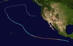
Hurricane Guillermo was the sixth strongest Pacific hurricane
on record, attaining peak winds of 160 mph (260 km/h) and a barometric pressure of 919 mbar (hPa; 27.14 inHg). Forming out of a tropical wave
on July 30, 1997, roughly 345 mi (555 km) south of Salina Cruz
, Mexico
, Guillermo tracked in a steady west-northwestward direction while intensifying. The system reached hurricane status by August 1 before undergoing rapid intensification
the following day. At the end of this phase, the storm attained its peak intensity as a powerful Category 5 hurricane. The storm began to weaken during the afternoon of August 5 and was downgraded to a tropical storm on August 8. Once entering the Central Pacific Hurricane Center
's area of responsibility, Guillermo briefly weakened to a tropical depression before re-attaining tropical storm status. On August 15, the storm reached an unusually high latitude of 41.8°N
before transitioning into an extratropical cyclone
. The remnants persisted for more than a week as they tracked towards the northeast and later south and east before being absorbed by a larger extratropical system off the coast of California
on August 24.
Throughout Guillermo's extensive track, the storm never threatened any major landmass, resulting in little impact on land. However, due to its extreme intensity, it produced large swells
across the Pacific Ocean, affecting areas from Hawaii
to coastal Mexico. Along the American Pacific coast, three people drowned due to high waves, two in Baja California and one in California. At its peak, Guillermo was the second strongest known Pacific hurricane on record; however, it has since been surpassed by four other storms, including Linda
later that year. The effects of Guillermo were not deemed severe enough to justify retirement of its name.
 Hurricane Guillermo began its extensive track as a tropical wave
that moved off the coast of Africa on July 16, 1997. Initially disorganized and weak, the system tracked westward across the Atlantic Ocean for several weeks. The National Hurricane Center
(NHC) stated that they had issues monitoring the system as it moved through the Caribbean; however, they interpreted through satellite data that the wave crossed Central America
and entered the Pacific Ocean between July 27 and 28. Once in the Pacific, convection
, areas of thunderstorm
activity, and banding features
began to form. Additionally, a low pressure system
developed within the disturbance by July 29. The following day, the system became sufficiently organized for the NHC to classify it as Tropical Depression Nine-E; at this time the depression was situated roughly 345 mi (555 km) south of Salina Cruz
, Mexico
. In response to a deep-layer ridge
to the north, the depression tracked at a steady pace towards the west-northwest, and this motion persisted through the first week of August. Within a day of being classified, the system intensified into Tropical Storm Guillermo, the seventh named storm
of the 1997 season
.
By the afternoon of August 1, a strong central dense overcast, an area of high, thick clouds, developed over the center of circulation, prompting the NHC to upgrade it to a Category 1 hurricane on the Saffir–Simpson Hurricane Scale. Throughout the next day, the system gradually developed an eye
within the central dense overcast, leading to further strengthening. Operationally, the Guillermo was thought to have briefly leveled out in intensity on August 2; however, in post-storm analysis, the NHC discovered that a steady period of rapid intensification
took place. Unlike most hurricanes in the eastern Pacific, Guillermo was investigated by Hurricane Hunters
reconnaissance aircraft during its rapid intensification stage. The aircraft released several dropsonde
s into the storm to gather meteorological data. This mission marked the first time the Hurricane Hunters recorded high-resolution wind data from flight level to within several meters of the ocean surface inside the eyewall of a major hurricane.
 Radar
Radar
was also employed to determine the size of the hurricane's eye, stated to be roughly 13 mi (20 km) in diameter, following a 6-mile (10 km) decrease due to the strengthening. Light wind shear
surrounding the hurricane allowed further strengthening to take place. Late on August 2, the system attained winds of 135 mph (215 km/h), making it a Category 4 storm. During the afternoon of August 3, Guillermo nearly attained Category 5 intensity as it reached its initial peak intensity with winds of 155 mph (250 km/h) along with a barometric pressure estimated at 925 mbar
(hPa
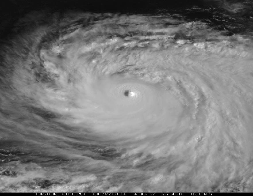
; 27.32 inHg). A brief period of weakening took place later that day before further strengthening ensued. Late on August 4, Guillermo intensified into a Category 5 hurricane, attaining peak winds of 160 mph (260 km/h). Operational analysis of satellite information indicated a minimum pressure of 921 mbar (hPa; 27.2 inHg); however, post-storm studies stated that the pressure was more likely around 919 mbar (hPa; 27.14 inHg).
At its peak, cloud temperatures within the eyewall
were estimated to be as low as -79 C. Using the Dvorak technique
, a method used to estimate the intensity of tropical cyclone
s, a value of 7.6 was obtained. This indicated that maximum winds at the surface could have been as high as 181 mph (291 km/h); however, this was not used as the reported intensity as six- to twelve-hour averages indicated sustained winds around 160 mph (260 km/h). After maintaining this intensity for roughly 18 hours, the system began to weaken as it moved into a less favorable environment with moderate wind shear. Cloud temperatures within the eyewall also began to increase, indicating that the hurricane was losing intensity.
Steady weakening took place over the following several days, and the storm dropped below major hurricane status on August 6. By August 8, Guillermo moved over colder waters and was downgraded to a tropical storm as sustained winds dropped below 75 mph (120 km/h). Around this time, the storm started to move along the western edge of the ridge that previously steered it towards the west-northwest, causing Guillermo to turn northwest. On August 9, the storm crossed longitude
140°W
, denoting a shift in warning responsibility from the NHC to the Central Pacific Hurricane Center
(CPHC). Not long after crossing into the CPHC's area of responsibility, the storm further weakened to a tropical depression as it moved over 24 °C (75.2 °F) waters.
Although most tropical cyclones generally weaken as they increase in latitude
, warm waters of 26 °C (78.8 °F) allowed Guillermo to re-intensify into a tropical storm on August 11. Gradually, the storm attained winds of 65 mph (100 km/h) before succumbing to cooler waters further north. The storm weakened to a tropical depression once more on August 15, situated well to the north of the Hawaiian islands
. Later that day, Guillermo transitioned into an extratropical cyclone
at an unusually high latitude of 41.8°N, roughly 850 mi (1,370 km) south-southeast of Unalaska, Alaska
. Over the following days, the remnants of the hurricane turned northeastward towards the Pacific coast of North America. On August 19, the system moved within 575 mi (925 km) of Vancouver Island
, British Columbia
before Guillermo tracked southward. Over the following few days, the system slowed significantly and turned towards the east. By August 20, moisture from the remnants of Tropical Storm Ignacio
were entrained into the eastern portion of Guillermo's circulation. On August 24, the low was finally absorbed by a larger extratropical system while situated roughly 345 mi (555 km) off of the northern California coastline.
to San José del Cabo
, the storm sent waves from the Sea of Cortez over the grounds of beachside resorts. Tourists were driven off some of Cabo's most popular beaches by the rough ocean conditions which flooded homes situated along the coast. Two sightseers were killed after being swept out to sea.
Due to accurate forecasts, emergency officials across California were able to close off swimming zones and warn the public about dangerous rip current
s prior to their arrival. Guillermo generated heavy surf across the beaches of Southern California. Heights from the surf averaged 6 to 8 ft (1.8 to 2.4 m) with local areas reaching above 10 feet (3 m), favorable to around 500 surfers at an annual competition at Huntington Beach. According to the Los Angeles Times
, some waves reached heights of 15 to 18 ft (4.6 to 5.5 m). Over 100 rescues were reported by local lifeguards. Waves ranging from 6 to 12 ft (1.8 to 3.7 m) also affected Orange County. Hundreds of people were rescued, but rip currents were blamed for three injuries and one death. On August 5, about a mile north of Huntington Beach pier, a 19-year old man was swept away. His body was recovered several days later. On August 6, a teenage boy and girl were injured on a beach in Corona Del Mar, while an 18-year old was pulled ashore and sent to the hospital with neck injuries. In Newport Beach
, lifeguards made nearly 300 rescues on August 5 and 6 alone.
In addition to coastal impacts, the system brought a surge of warm, moist air into southern California, bringing temperatures in some areas as high as 110 °F (43.3 °C). Between August 15 and 17, large waves generated while it was at peak intensity came ashore in Hawaii. The swells caused no damage and reached heights of 10 feet (3 m) in eastern-facing shores of the state.
Hurricane Guillermo's central pressure of 919 mbar (hPa; 27.14 inHg) established it as the second most intense Pacific hurricane on record behind Hurricane Ava
of 1973
. However, later in the 1997 season, Hurricane Linda
set a new intensity record, and in subsequent years hurricanes Kenna
, Ioke
and Rick
all achieved lower pressures, leaving Guillermo in sixth place. As of , Guillermo remains the strongest Pacific hurricane during the month of August. Guillermo persisted for 16.5 days from its classification as a tropical depression to its transition into an extratropical storm, making it the sixth longest-lasting storm in the basin.
Pacific hurricane
A Pacific hurricane or tropical storm is a tropical cyclone that develops in the northeastern part of the Pacific Ocean. For organizational purposes, the northern Pacific Ocean is divided into three regions: the eastern, , central , and western...
on record, attaining peak winds of 160 mph (260 km/h) and a barometric pressure of 919 mbar (hPa; 27.14 inHg). Forming out of a tropical wave
Tropical wave
Tropical waves, easterly waves, or tropical easterly waves, also known as African easterly waves in the Atlantic region, are a type of atmospheric trough, an elongated area of relatively low air pressure, oriented north to south, which move from east to west across the tropics causing areas of...
on July 30, 1997, roughly 345 mi (555 km) south of Salina Cruz
Salina Cruz
Salina Cruz is a major seaport on the Pacific coast of the Mexican state of Oaxaca. It is the state's third-largest city and is municipal seat of the municipality of the same name.It is part of the Tehuantepec District in the west of the Istmo Region....
, Mexico
Mexico
The United Mexican States , commonly known as Mexico , is a federal constitutional republic in North America. It is bordered on the north by the United States; on the south and west by the Pacific Ocean; on the southeast by Guatemala, Belize, and the Caribbean Sea; and on the east by the Gulf of...
, Guillermo tracked in a steady west-northwestward direction while intensifying. The system reached hurricane status by August 1 before undergoing rapid intensification
Rapid deepening
Rapid deepening, also known as rapid intensification, is a meteorological condition that occurs when the minimum sea-level atmospheric pressure of a tropical cyclone decreases drastically in a short period of time. The National Weather Service describes rapid deepening as a decrease of...
the following day. At the end of this phase, the storm attained its peak intensity as a powerful Category 5 hurricane. The storm began to weaken during the afternoon of August 5 and was downgraded to a tropical storm on August 8. Once entering the Central Pacific Hurricane Center
Central Pacific Hurricane Center
The Central Pacific Hurricane Center of the United States National Weather Service is the official body responsible for tracking and issuing tropical cyclone warnings, watches, advisories, discussions, and statements for the Central North Pacific Basin...
's area of responsibility, Guillermo briefly weakened to a tropical depression before re-attaining tropical storm status. On August 15, the storm reached an unusually high latitude of 41.8°N
Latitude
In geography, the latitude of a location on the Earth is the angular distance of that location south or north of the Equator. The latitude is an angle, and is usually measured in degrees . The equator has a latitude of 0°, the North pole has a latitude of 90° north , and the South pole has a...
before transitioning into an extratropical cyclone
Extratropical cyclone
Extratropical cyclones, sometimes called mid-latitude cyclones or wave cyclones, are a group of cyclones defined as synoptic scale low pressure weather systems that occur in the middle latitudes of the Earth having neither tropical nor polar characteristics, and are connected with fronts and...
. The remnants persisted for more than a week as they tracked towards the northeast and later south and east before being absorbed by a larger extratropical system off the coast of California
California
California is a state located on the West Coast of the United States. It is by far the most populous U.S. state, and the third-largest by land area...
on August 24.
Throughout Guillermo's extensive track, the storm never threatened any major landmass, resulting in little impact on land. However, due to its extreme intensity, it produced large swells
Swell (ocean)
A swell, in the context of an ocean, sea or lake, is a series surface gravity waves that is not generated by the local wind. Swell waves often have a long wavelength but this varies with the size of the water body, e.g. rarely more than 150 m in the Mediterranean, and from event to event, with...
across the Pacific Ocean, affecting areas from Hawaii
Hawaii
Hawaii is the newest of the 50 U.S. states , and is the only U.S. state made up entirely of islands. It is the northernmost island group in Polynesia, occupying most of an archipelago in the central Pacific Ocean, southwest of the continental United States, southeast of Japan, and northeast of...
to coastal Mexico. Along the American Pacific coast, three people drowned due to high waves, two in Baja California and one in California. At its peak, Guillermo was the second strongest known Pacific hurricane on record; however, it has since been surpassed by four other storms, including Linda
Hurricane Linda (1997)
Hurricane Linda was the strongest eastern Pacific hurricane on record. Forming from a tropical wave on September 9, 1997, Linda steadily intensified and reached hurricane status within 36 hours of developing. It rapidly intensified, reaching winds of and an estimated central pressure...
later that year. The effects of Guillermo were not deemed severe enough to justify retirement of its name.
Meteorological history
Tropical wave
Tropical waves, easterly waves, or tropical easterly waves, also known as African easterly waves in the Atlantic region, are a type of atmospheric trough, an elongated area of relatively low air pressure, oriented north to south, which move from east to west across the tropics causing areas of...
that moved off the coast of Africa on July 16, 1997. Initially disorganized and weak, the system tracked westward across the Atlantic Ocean for several weeks. The National Hurricane Center
National Hurricane Center
The National Hurricane Center , located at Florida International University in Miami, Florida, is the division of the National Weather Service responsible for tracking and predicting weather systems within the tropics between the Prime Meridian and the 140th meridian west poleward to the 30th...
(NHC) stated that they had issues monitoring the system as it moved through the Caribbean; however, they interpreted through satellite data that the wave crossed Central America
Central America
Central America is the central geographic region of the Americas. It is the southernmost, isthmian portion of the North American continent, which connects with South America on the southeast. When considered part of the unified continental model, it is considered a subcontinent...
and entered the Pacific Ocean between July 27 and 28. Once in the Pacific, convection
Atmospheric convection
Atmospheric convection is the result of a parcel-environment instability, or temperature difference, layer in the atmosphere. Different lapse rates within dry and moist air lead to instability. Mixing of air during the day which expands the height of the planetary boundary layer leads to...
, areas of thunderstorm
Thunderstorm
A thunderstorm, also known as an electrical storm, a lightning storm, thundershower or simply a storm is a form of weather characterized by the presence of lightning and its acoustic effect on the Earth's atmosphere known as thunder. The meteorologically assigned cloud type associated with the...
activity, and banding features
Rainband
A rainband is a cloud and precipitation structure associated with an area of rainfall which is significantly elongated. Rainbands can be stratiform or convective, and are generated by differences in temperature. When noted on weather radar imagery, this precipitation elongation is referred to as...
began to form. Additionally, a low pressure system
Low pressure area
A low-pressure area, or "low", is a region where the atmospheric pressure at sea level is below that of surrounding locations. Low-pressure systems form under areas of wind divergence which occur in upper levels of the troposphere. The formation process of a low-pressure area is known as...
developed within the disturbance by July 29. The following day, the system became sufficiently organized for the NHC to classify it as Tropical Depression Nine-E; at this time the depression was situated roughly 345 mi (555 km) south of Salina Cruz
Salina Cruz
Salina Cruz is a major seaport on the Pacific coast of the Mexican state of Oaxaca. It is the state's third-largest city and is municipal seat of the municipality of the same name.It is part of the Tehuantepec District in the west of the Istmo Region....
, Mexico
Mexico
The United Mexican States , commonly known as Mexico , is a federal constitutional republic in North America. It is bordered on the north by the United States; on the south and west by the Pacific Ocean; on the southeast by Guatemala, Belize, and the Caribbean Sea; and on the east by the Gulf of...
. In response to a deep-layer ridge
Ridge (meteorology)
A ridge is an elongated region of relatively high atmospheric pressure, the opposite of a trough....
to the north, the depression tracked at a steady pace towards the west-northwest, and this motion persisted through the first week of August. Within a day of being classified, the system intensified into Tropical Storm Guillermo, the seventh named storm
Tropical cyclone naming
Tropical cyclones have officially been named since 1945 and are named for a variety of reasons, which include to facilitate communications between forecasters and the public when forecasts, watches, and warnings are issued. Names also reduce confusion about what storm is being described, as more...
of the 1997 season
1997 Pacific hurricane season
The 1997 Pacific hurricane season was a very active hurricane season. With hundreds of deaths and billions of dollars in damage, this season was the costliest and one of the deadliest Pacific hurricane seasons. This was due to a strong El Niño...
.
By the afternoon of August 1, a strong central dense overcast, an area of high, thick clouds, developed over the center of circulation, prompting the NHC to upgrade it to a Category 1 hurricane on the Saffir–Simpson Hurricane Scale. Throughout the next day, the system gradually developed an eye
Eye (cyclone)
The eye is a region of mostly calm weather found at the center of strong tropical cyclones. The eye of a storm is a roughly circular area and typically 30–65 km in diameter. It is surrounded by the eyewall, a ring of towering thunderstorms where the second most severe weather of a cyclone...
within the central dense overcast, leading to further strengthening. Operationally, the Guillermo was thought to have briefly leveled out in intensity on August 2; however, in post-storm analysis, the NHC discovered that a steady period of rapid intensification
Rapid deepening
Rapid deepening, also known as rapid intensification, is a meteorological condition that occurs when the minimum sea-level atmospheric pressure of a tropical cyclone decreases drastically in a short period of time. The National Weather Service describes rapid deepening as a decrease of...
took place. Unlike most hurricanes in the eastern Pacific, Guillermo was investigated by Hurricane Hunters
Hurricane Hunters
The Hurricane Hunters are aircraft that fly into tropical cyclones in the North Atlantic Ocean and Northeastern Pacific Ocean for the specific purpose of directly measuring weather data in and around those storms. In the United States, the Air Force, Navy, and NOAA units have all participated in...
reconnaissance aircraft during its rapid intensification stage. The aircraft released several dropsonde
Dropsonde
A dropsonde is a weather reconnaissance device created by the National Center for Atmospheric Research , designed to be dropped from an aircraft at altitude to more accurately measure tropical storm conditions as the device falls to the surface...
s into the storm to gather meteorological data. This mission marked the first time the Hurricane Hunters recorded high-resolution wind data from flight level to within several meters of the ocean surface inside the eyewall of a major hurricane.
Radar
Radar is an object-detection system which uses radio waves to determine the range, altitude, direction, or speed of objects. It can be used to detect aircraft, ships, spacecraft, guided missiles, motor vehicles, weather formations, and terrain. The radar dish or antenna transmits pulses of radio...
was also employed to determine the size of the hurricane's eye, stated to be roughly 13 mi (20 km) in diameter, following a 6-mile (10 km) decrease due to the strengthening. Light wind shear
Wind shear
Wind shear, sometimes referred to as windshear or wind gradient, is a difference in wind speed and direction over a relatively short distance in the atmosphere...
surrounding the hurricane allowed further strengthening to take place. Late on August 2, the system attained winds of 135 mph (215 km/h), making it a Category 4 storm. During the afternoon of August 3, Guillermo nearly attained Category 5 intensity as it reached its initial peak intensity with winds of 155 mph (250 km/h) along with a barometric pressure estimated at 925 mbar
Bar (unit)
The bar is a unit of pressure equal to 100 kilopascals, and roughly equal to the atmospheric pressure on Earth at sea level. Other units derived from the bar are the megabar , kilobar , decibar , centibar , and millibar...
(hPa
Pascal (unit)
The pascal is the SI derived unit of pressure, internal pressure, stress, Young's modulus and tensile strength, named after the French mathematician, physicist, inventor, writer, and philosopher Blaise Pascal. It is a measure of force per unit area, defined as one newton per square metre...
; 27.32 inHg). A brief period of weakening took place later that day before further strengthening ensued. Late on August 4, Guillermo intensified into a Category 5 hurricane, attaining peak winds of 160 mph (260 km/h). Operational analysis of satellite information indicated a minimum pressure of 921 mbar (hPa; 27.2 inHg); however, post-storm studies stated that the pressure was more likely around 919 mbar (hPa; 27.14 inHg).
At its peak, cloud temperatures within the eyewall
Eye (cyclone)
The eye is a region of mostly calm weather found at the center of strong tropical cyclones. The eye of a storm is a roughly circular area and typically 30–65 km in diameter. It is surrounded by the eyewall, a ring of towering thunderstorms where the second most severe weather of a cyclone...
were estimated to be as low as -79 C. Using the Dvorak technique
Dvorak technique
The Dvorak technique is a widely used system to subjectively estimate tropical cyclone intensity based solely on visible and infrared satellite images. Several agencies issue Dvorak intensity numbers for cyclones of sufficient intensity...
, a method used to estimate the intensity of tropical cyclone
Tropical cyclone
A tropical cyclone is a storm system characterized by a large low-pressure center and numerous thunderstorms that produce strong winds and heavy rain. Tropical cyclones strengthen when water evaporated from the ocean is released as the saturated air rises, resulting in condensation of water vapor...
s, a value of 7.6 was obtained. This indicated that maximum winds at the surface could have been as high as 181 mph (291 km/h); however, this was not used as the reported intensity as six- to twelve-hour averages indicated sustained winds around 160 mph (260 km/h). After maintaining this intensity for roughly 18 hours, the system began to weaken as it moved into a less favorable environment with moderate wind shear. Cloud temperatures within the eyewall also began to increase, indicating that the hurricane was losing intensity.
Steady weakening took place over the following several days, and the storm dropped below major hurricane status on August 6. By August 8, Guillermo moved over colder waters and was downgraded to a tropical storm as sustained winds dropped below 75 mph (120 km/h). Around this time, the storm started to move along the western edge of the ridge that previously steered it towards the west-northwest, causing Guillermo to turn northwest. On August 9, the storm crossed longitude
Longitude
Longitude is a geographic coordinate that specifies the east-west position of a point on the Earth's surface. It is an angular measurement, usually expressed in degrees, minutes and seconds, and denoted by the Greek letter lambda ....
140°W
140th meridian west
The meridian 140° west of Greenwich is a line of longitude that extends from the North Pole across the Arctic Ocean, North America, the Pacific Ocean, the Southern Ocean, and Antarctica to the South Pole....
, denoting a shift in warning responsibility from the NHC to the Central Pacific Hurricane Center
Central Pacific Hurricane Center
The Central Pacific Hurricane Center of the United States National Weather Service is the official body responsible for tracking and issuing tropical cyclone warnings, watches, advisories, discussions, and statements for the Central North Pacific Basin...
(CPHC). Not long after crossing into the CPHC's area of responsibility, the storm further weakened to a tropical depression as it moved over 24 °C (75.2 °F) waters.
Although most tropical cyclones generally weaken as they increase in latitude
Latitude
In geography, the latitude of a location on the Earth is the angular distance of that location south or north of the Equator. The latitude is an angle, and is usually measured in degrees . The equator has a latitude of 0°, the North pole has a latitude of 90° north , and the South pole has a...
, warm waters of 26 °C (78.8 °F) allowed Guillermo to re-intensify into a tropical storm on August 11. Gradually, the storm attained winds of 65 mph (100 km/h) before succumbing to cooler waters further north. The storm weakened to a tropical depression once more on August 15, situated well to the north of the Hawaiian islands
Hawaiian Islands
The Hawaiian Islands are an archipelago of eight major islands, several atolls, numerous smaller islets, and undersea seamounts in the North Pacific Ocean, extending some 1,500 miles from the island of Hawaii in the south to northernmost Kure Atoll...
. Later that day, Guillermo transitioned into an extratropical cyclone
Extratropical cyclone
Extratropical cyclones, sometimes called mid-latitude cyclones or wave cyclones, are a group of cyclones defined as synoptic scale low pressure weather systems that occur in the middle latitudes of the Earth having neither tropical nor polar characteristics, and are connected with fronts and...
at an unusually high latitude of 41.8°N, roughly 850 mi (1,370 km) south-southeast of Unalaska, Alaska
Unalaska, Alaska
Unalaska is a city in the Aleutians West Census Area of the Unorganized Borough of the U.S. state of Alaska. Unalaska is located on Unalaska Island and neighboring Amaknak Island in the Aleutian Islands off of mainland Alaska....
. Over the following days, the remnants of the hurricane turned northeastward towards the Pacific coast of North America. On August 19, the system moved within 575 mi (925 km) of Vancouver Island
Vancouver Island
Vancouver Island is a large island in British Columbia, Canada. It is one of several North American locations named after George Vancouver, the British Royal Navy officer who explored the Pacific Northwest coast of North America between 1791 and 1794...
, British Columbia
British Columbia
British Columbia is the westernmost of Canada's provinces and is known for its natural beauty, as reflected in its Latin motto, Splendor sine occasu . Its name was chosen by Queen Victoria in 1858...
before Guillermo tracked southward. Over the following few days, the system slowed significantly and turned towards the east. By August 20, moisture from the remnants of Tropical Storm Ignacio
Tropical Storm Ignacio (1997)
Tropical Storm Ignacio was a weak tropical cyclone that existed during August 1997. The 12th tropical cyclone and 9th named storm of the 1997 Pacific hurricane season, Ignacio formed west of Mexico from a weather disturbance embedded within a more broad system...
were entrained into the eastern portion of Guillermo's circulation. On August 24, the low was finally absorbed by a larger extratropical system while situated roughly 345 mi (555 km) off of the northern California coastline.
Impact and records
Along the Pacific coast of Mexico, 12 feet (3.7 m) surf produced by Hurricane Guillermo affected numerous beaches. From Cabo San LucasCabo San Lucas
Cabo San Lucas , commonly called Cabo, is a city at the southern tip of the Baja California peninsula, in the municipality of Los Cabos in the Mexican state of Baja California Sur. As of the 2010 census, the population was 68,463 people...
to San José del Cabo
San José del Cabo
The city of San José del Cabo is located in Baja California Sur Mexico and is the seat of the municipality of Los Cabos at the south end of the Baja California peninsula. In the 2010 census it had a population of 69,788. Together with neighboring Cabo San Lucas it forms a major tourist destination...
, the storm sent waves from the Sea of Cortez over the grounds of beachside resorts. Tourists were driven off some of Cabo's most popular beaches by the rough ocean conditions which flooded homes situated along the coast. Two sightseers were killed after being swept out to sea.
Due to accurate forecasts, emergency officials across California were able to close off swimming zones and warn the public about dangerous rip current
Rip current
A rip current, commonly referred to by the misnomer rip tide, is a strong channel of water flowing seaward from near the shore, typically through the surf line. Typical flow is at 0.5 metres per second , and can be as fast as 2.5 metres per second...
s prior to their arrival. Guillermo generated heavy surf across the beaches of Southern California. Heights from the surf averaged 6 to 8 ft (1.8 to 2.4 m) with local areas reaching above 10 feet (3 m), favorable to around 500 surfers at an annual competition at Huntington Beach. According to the Los Angeles Times
Los Angeles Times
The Los Angeles Times is a daily newspaper published in Los Angeles, California, since 1881. It was the second-largest metropolitan newspaper in circulation in the United States in 2008 and the fourth most widely distributed newspaper in the country....
, some waves reached heights of 15 to 18 ft (4.6 to 5.5 m). Over 100 rescues were reported by local lifeguards. Waves ranging from 6 to 12 ft (1.8 to 3.7 m) also affected Orange County. Hundreds of people were rescued, but rip currents were blamed for three injuries and one death. On August 5, about a mile north of Huntington Beach pier, a 19-year old man was swept away. His body was recovered several days later. On August 6, a teenage boy and girl were injured on a beach in Corona Del Mar, while an 18-year old was pulled ashore and sent to the hospital with neck injuries. In Newport Beach
Newport Beach, California
Newport Beach, incorporated in 1906, is a city in Orange County, California, south of downtown Santa Ana. The population was 85,186 at the 2010 census.The city's median family income and property values consistently place high in national rankings...
, lifeguards made nearly 300 rescues on August 5 and 6 alone.
In addition to coastal impacts, the system brought a surge of warm, moist air into southern California, bringing temperatures in some areas as high as 110 °F (43.3 °C). Between August 15 and 17, large waves generated while it was at peak intensity came ashore in Hawaii. The swells caused no damage and reached heights of 10 feet (3 m) in eastern-facing shores of the state.
Hurricane Guillermo's central pressure of 919 mbar (hPa; 27.14 inHg) established it as the second most intense Pacific hurricane on record behind Hurricane Ava
Hurricane Ava (1973)
Hurricane Ava was one of the strongest tropical cyclones ever recorded in the northeastern Pacific Ocean. It was the first named storm of the 1973 Pacific hurricane season. Forming in early June, Hurricane Ava eventually reached Category 5 intensity on the Saffir-Simpson Hurricane Scale, the...
of 1973
1973 Pacific hurricane season
The 1973 Pacific hurricane season was an event in tropical cyclone meteorology. The most important system this year was Hurricane Ava, which was the most intense Pacific hurricane known at the time. Several other much weaker tropical cyclones came close to, or made landfall on, the Pacific coast of...
. However, later in the 1997 season, Hurricane Linda
Hurricane Linda (1997)
Hurricane Linda was the strongest eastern Pacific hurricane on record. Forming from a tropical wave on September 9, 1997, Linda steadily intensified and reached hurricane status within 36 hours of developing. It rapidly intensified, reaching winds of and an estimated central pressure...
set a new intensity record, and in subsequent years hurricanes Kenna
Hurricane Kenna
Hurricane Kenna was the second-most intense Pacific hurricane to strike the west coast of Mexico in recorded history. Kenna was the sixteenth tropical depression, thirteenth tropical storm, seventh hurricane, sixth major hurricane, and third Category 5 hurricane of the 2002 Pacific hurricane season...
, Ioke
Hurricane Ioke
Hurricane Ioke was the strongest hurricane ever recorded in the Central Pacific...
and Rick
Hurricane Rick (2009)
Hurricane Rick was the second-most intense Pacific hurricane on record and the strongest ever to form during October. Developing south of Mexico on October 15, 2009, Hurricane Rick traversed an area favoring rapid intensification, allowing it to become a hurricane within 24 hours of being...
all achieved lower pressures, leaving Guillermo in sixth place. As of , Guillermo remains the strongest Pacific hurricane during the month of August. Guillermo persisted for 16.5 days from its classification as a tropical depression to its transition into an extratropical storm, making it the sixth longest-lasting storm in the basin.
See also
- List of Category 5 Pacific hurricanes
- List of Pacific hurricanes
- Timeline of the 1997 Pacific hurricane seasonTimeline of the 1997 Pacific hurricane seasonThe 1997 Pacific hurricane season was the most active season since the 1994 season, producing 24 tropical depressions, 19 of which became tropical storms or hurricanes. The season officially started on May 15, 1997 in the Eastern Pacific—designated as the area east of 140°W—and on June 1, 1997...