
Hurricane Diana
Encyclopedia
Hurricane Diana was the deadliest tropical cyclone
during the 1990 Atlantic hurricane season
, killing 139 people in Mexico
. Forming out of a tropical wave
on August 4, the system brushed Honduras
before intensifying into a tropical storm the following day. Gradually gaining strength, Diana struck the Yucatán Peninsula
with winds of 65 mph (100 km/h). Due to the interaction with land, the cyclone weakened somewhat before moving over the warm waters of the Bay of Campeche
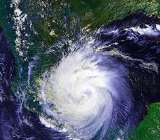
on August 6. Once over water, the Diana quickly became a hurricane and later reached its peak intensity on August 7 as a Category 2 on the Saffir–Simpson Hurricane Scale. Shortly thereafter, the storm made landfall
near Tampico, Tamaulipas with winds of 100 mph (165 km/h). Rapid weakening ensued once the storm moved over the high terrain of Mexico and Diana diminished to a tropical depression roughly 24 hours after moving onshore. The cyclone later emerged into the Gulf of California
on August 9 before losing all tropical characteristics, though its remnants were monitored until August 14 when the system lost its identity over Arizona
.
Throughout Mexico, Hurricane Diana produced torrential rains that triggered deadly flooding and landslides. Roughly 155 mi² (400 km²) of farmland was destroyed and 30,000 people were left homeless by the storm. Numerous roads and railways were either washed out or blocked by debris, cutting communication with several communities. In all, 139 people were killed in the country and $90 million (1990 USD
) was wrought in damage. Due to the extensive loss of life and damage caused by Hurricane Diana, its name was retired the following year and replaced with Dolly.
on July 27. Conditions were unfavorable for development of a tropical cyclone, and the tropical wave remained disorganized until reaching the eastern Caribbean Sea. The system entered the Caribbean Sea through the southern Windward Islands
, where falling barometric pressures were observed, decreasing by 3.5 mbar
(hPa
; 0.1 inHg
) in 24 hours. Upper-level air data from the Lesser Antilles
indicated that the tropical wave was associated with an upper-level anticyclone. With increasing convection, the first Air Force reconnaissance plane flight indicated no low-level circulation, but a relatively large amount of thunderstorm activity. The system continued to have a large amount of associated convection while passing over the Netherlands Antilles
, as indicated by satellite images and surface observations. Cyclonic rotation was observed in the low-level convection by satellite images, and the fifth tropical depression of the season had developed at 0000 UTC on August 4, situated in the southwestern Caribbean Sea. However, this was based on surface observations, and it was not confirmed that tropical cyclone formation occurred until later that day.
The new tropical depression moved to the northwest under the influence of a mid-level trough, and rapidly intensified to a tropical storm the following day offshore of eastern Honduras; the National Hurricane Center
assigned the system to the name Diana. Becoming a tropical storm, Diana further intensified, and winds reached 65 mph (105 km/h) before landfall in Felipe Carrillo Puerto
in Quintana Roo
occurred. The storm initially rapidly weakened over land, although it retained winds of 50 mph (80 km/h) until moving over open waters. When Diana entered the southern Gulf of Mexico, the trough of low pressure in that vicinity weakened and steering currents caused the storm to head westward. Conditions became more favorable in the Gulf of Mexico, and Diana quickly intensified, becoming a hurricane late on August 7. Hurricane Diana rapidly intensified, and briefly reached category 2 hurricane status, attaining peak intensity with winds of 100 mph (165 km/h) and a minimum barometric pressure of 980 mbar (hPa; 28.94 inHg). Only two hours after attaining peak intensity on August 7, Hurricane Diana made landfall near Tampico, Tamaulipas at the same intensity.
Moving inland, Diana rapidly weakened over the high terrain of Mexico, quickly deteriorating from a low-end category 2 hurricane immediately to a strong tropical storm just four hours later. Diana continued westward over Mexico, and weakened to a tropical depression on August 8, while centered near Mexico City
. The weakening tropical depression turned west-northwestward over central Mexico, and emerged into the Pacific Ocean on August 9, before dissipating in the Gulf of California
. The remnants of Hurricane Diana curved northward and tracked trough the Gulf of California, and eventually came ashore in northwestern Sonora
. Crossing northwestern Mexico, the remnants of Diana entered Arizona
and quickly dissipated.
, Mexico southward to Belize City
, Belize on August 5, including the offshore islands from both nations; a tropical storm warning indicates that tropical storm force winds, 39 to 73 mph (39 to 118 km/h), are expected within 24 hours. Eleven hours later, the tropical storm warning was extended as far as Carmen, but was discontinued for the entire east coast of Belize. After Diana made landfall on the Yucatán Peninsula on August 6, all of the tropical storm warnings in place were discontinued.
Nine hours after all warnings were along the Yucatán Peninsula, Diana began to threaten the mainland east coast of Mexico, and a hurricane watch was issued for Tuxpan to Boca de Jesus Maria; a hurricane watch notes the possibility of hurricane conditions within 48 hours, such as winds of at least 74 mph (119 km/h). Early on August 7, the National Hurricane Center anticipated on hurricane conditions within 24 hours, and as a result, a hurricane warning was issued for Nautla to Le Pesca
. Simultaneously, a tropical storm warning was issued for La Pesca to Boca de Jesus Maria. Later that day, a hurricane warning had been issued for a similar area, stretching from Nautla to Lerdo de Tejada. By 0000 UTC
on August 8, all of the watches and warnings in place were officially discontinued. According to Miguelangel Rebolledo, the captain of the port of Tuxpan, about 300 people fled low-lying areas.
, sustained winds of 45 mph (75 km/h) was reported. While crossing over the Yucatán Peninsula, Mérida
reported winds of 34 mph (54 km/h) with gusts of 40 mph (65 km/h). In addition, wind gusts of 37 and 45 mph (59.5 and 72.4 km/h) were reported in the towns of Felipe Carrillo Puerto and José María Morelos, respectively. Diana also caused heavy rain across the area, though damage is unknown. Due to heavy rainfall, minor street flooding occurred in Chetumal, Quintana Roo.
Rough seas were reported mainly between Coatzacoalcos
and Tampico; the ports of those two cities were closed during the passage of Diana, according to the National Weather Service. While passing through the Bay of Campeche
and the southern Gulf of Mexico, Diana produced waves up to 12 ft (3.6 m) in height. On mainland Mexico, the states of Veracruz
, Hidalgo, and Puebla
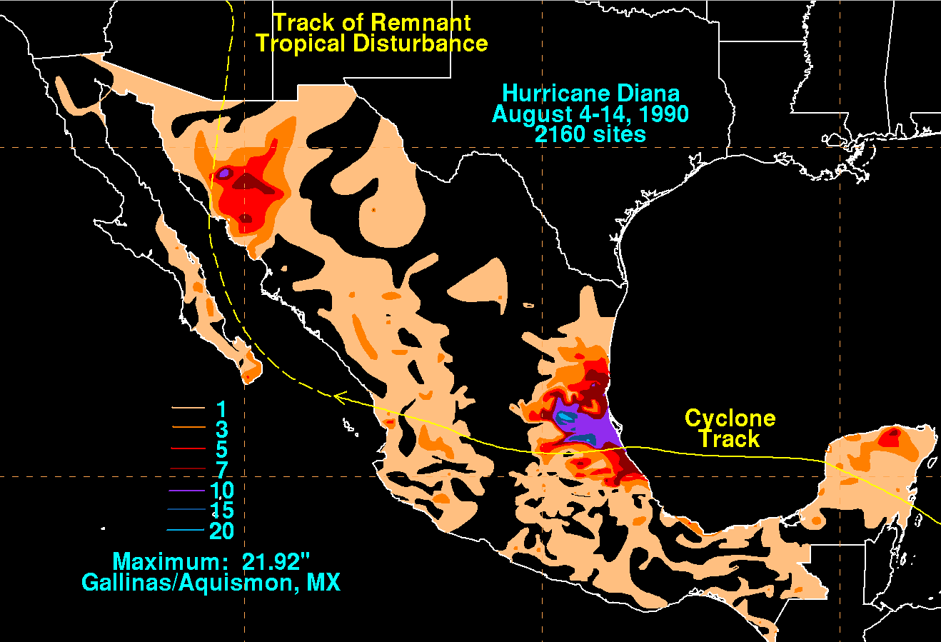
were hardest hit, with over 75,000 people affected by the hurricane. In Poza Rica, high winds toppled trees and electricity poles, which cut off telephone services and electricity supply to the city. Fallen trees and telephone wires also blocked some streets in the area, but the major roads remained open. Diana caused torrential rainfall while crossing the country, which peaked at 21.92 in (556.8 mm) in Aquismón
, San Luis Potosí
. Heavy rainfall triggered mudslides and flooding, mostly in the east-central portion of Mexico. The rainfall caused extensive property damage, destroying numerous houses and leaving 3,500 homeless. The torrential rain blocked highways and railways across six states. Furthermore, the flooding also destroyed 155 mi² (400 km²) of farmland. In addition, it is estimated that Diana injured 25,000 people. Several miners were reported dead, after their truck plunged into a ravine. Excluding the 56 people that were missing by the end of 1990, Hurricane Diana caused 139 deaths, and $90.7 million in damage (1990 USD; $ USD). However, some sources claim that there were as much as 391 fatalities and losses incurred by the storm totaled to (1990 USD; $ USD).
Following the storm, the Mexican Armed Forces
delivered food and basic health care supplies. In addition, there was also a mass vaccination against typhoid
.
, bringing heavy rainfall to the region. In Imperial County, California
, golf-ball sized hail was reported by the residents, along with rain and lightning, causing briefly power outages throughout the county. A police dispatch of Imperial County also noted local flooding, which resulted in traffic disruptions. The remnants of Diana also dropped light rainfall in San Diego County, California
, with the city of San Diego receiving only a trace of rain, Vista
reporting 0.09 in (2 mm), Del Mar
had 0.08 in (2 mm), and Oceanside
measuring 0.3 in (8 mm).
Due to its impact, the name Diana was retired by the World Meteorological Organization
in the spring of 1991, and will never be used again for another Atlantic hurricane. It was replaced with Dolly for the 1996 season
. This Hurricane Diana is not to be confused with the 1955 season
's Hurricane Diane
, which was also retired.
Tropical cyclone
A tropical cyclone is a storm system characterized by a large low-pressure center and numerous thunderstorms that produce strong winds and heavy rain. Tropical cyclones strengthen when water evaporated from the ocean is released as the saturated air rises, resulting in condensation of water vapor...
during the 1990 Atlantic hurricane season
1990 Atlantic hurricane season
The 1990 Atlantic hurricane season was the most active Atlantic hurricane season since 1969. It officially began on June 1, 1990, and lasted until November 30, 1990. These dates conventionally delimit the period of each year when most tropical cyclones form in the Atlantic basin...
, killing 139 people in Mexico
Mexico
The United Mexican States , commonly known as Mexico , is a federal constitutional republic in North America. It is bordered on the north by the United States; on the south and west by the Pacific Ocean; on the southeast by Guatemala, Belize, and the Caribbean Sea; and on the east by the Gulf of...
. Forming out of a tropical wave
Tropical wave
Tropical waves, easterly waves, or tropical easterly waves, also known as African easterly waves in the Atlantic region, are a type of atmospheric trough, an elongated area of relatively low air pressure, oriented north to south, which move from east to west across the tropics causing areas of...
on August 4, the system brushed Honduras
Honduras
Honduras is a republic in Central America. It was previously known as Spanish Honduras to differentiate it from British Honduras, which became the modern-day state of Belize...
before intensifying into a tropical storm the following day. Gradually gaining strength, Diana struck the Yucatán Peninsula
Yucatán Peninsula
The Yucatán Peninsula, in southeastern Mexico, separates the Caribbean Sea from the Gulf of Mexico, with the northern coastline on the Yucatán Channel...
with winds of 65 mph (100 km/h). Due to the interaction with land, the cyclone weakened somewhat before moving over the warm waters of the Bay of Campeche
Bay of Campeche
The Bay of Campeche is the southern bight of the Gulf of Mexico. It is surrounded on three sides by the Mexican states of Campeche, Tabasco and Veracruz. It was named by Francisco Hernández de Córdoba and Antonio de Alaminos during their expedition in 1517...
on August 6. Once over water, the Diana quickly became a hurricane and later reached its peak intensity on August 7 as a Category 2 on the Saffir–Simpson Hurricane Scale. Shortly thereafter, the storm made landfall
Landfall (meteorology)
Landfall is the event of a tropical cyclone or a waterspout coming onto land after being over water. When a waterspout makes landfall it is reclassified as a tornado, which can then cause damage inland...
near Tampico, Tamaulipas with winds of 100 mph (165 km/h). Rapid weakening ensued once the storm moved over the high terrain of Mexico and Diana diminished to a tropical depression roughly 24 hours after moving onshore. The cyclone later emerged into the Gulf of California
Gulf of California
The Gulf of California is a body of water that separates the Baja California Peninsula from the Mexican mainland...
on August 9 before losing all tropical characteristics, though its remnants were monitored until August 14 when the system lost its identity over Arizona
Arizona
Arizona ; is a state located in the southwestern region of the United States. It is also part of the western United States and the mountain west. The capital and largest city is Phoenix...
.
Throughout Mexico, Hurricane Diana produced torrential rains that triggered deadly flooding and landslides. Roughly 155 mi² (400 km²) of farmland was destroyed and 30,000 people were left homeless by the storm. Numerous roads and railways were either washed out or blocked by debris, cutting communication with several communities. In all, 139 people were killed in the country and $90 million (1990 USD
United States dollar
The United States dollar , also referred to as the American dollar, is the official currency of the United States of America. It is divided into 100 smaller units called cents or pennies....
) was wrought in damage. Due to the extensive loss of life and damage caused by Hurricane Diana, its name was retired the following year and replaced with Dolly.
Meteorological history
The origins of Hurricane Diana were from a tropical wave that emerged into the Atlantic from the west coast of AfricaAfrica
Africa is the world's second largest and second most populous continent, after Asia. At about 30.2 million km² including adjacent islands, it covers 6% of the Earth's total surface area and 20.4% of the total land area...
on July 27. Conditions were unfavorable for development of a tropical cyclone, and the tropical wave remained disorganized until reaching the eastern Caribbean Sea. The system entered the Caribbean Sea through the southern Windward Islands
Windward Islands
The Windward Islands are the southern islands of the Lesser Antilles, within the West Indies.-Name and geography:The Windward Islands are called such because they were more windward to sailing ships arriving in the New World than the Leeward Islands, given that the prevailing trade winds in the...
, where falling barometric pressures were observed, decreasing by 3.5 mbar
Bar (unit)
The bar is a unit of pressure equal to 100 kilopascals, and roughly equal to the atmospheric pressure on Earth at sea level. Other units derived from the bar are the megabar , kilobar , decibar , centibar , and millibar...
(hPa
Pascal (unit)
The pascal is the SI derived unit of pressure, internal pressure, stress, Young's modulus and tensile strength, named after the French mathematician, physicist, inventor, writer, and philosopher Blaise Pascal. It is a measure of force per unit area, defined as one newton per square metre...
; 0.1 inHg
Inch of mercury
Inches of mercury, ' is a unit of measurement for pressure. It is still widely used for barometric pressure in weather reports, refrigeration and aviation in the United States, but is seldom used elsewhere....
) in 24 hours. Upper-level air data from the Lesser Antilles
Lesser Antilles
The Lesser Antilles are a long, partly volcanic island arc in the Western Hemisphere. Most of its islands form the eastern boundary of the Caribbean Sea with the Atlantic Ocean, with the remainder located in the southern Caribbean just north of South America...
indicated that the tropical wave was associated with an upper-level anticyclone. With increasing convection, the first Air Force reconnaissance plane flight indicated no low-level circulation, but a relatively large amount of thunderstorm activity. The system continued to have a large amount of associated convection while passing over the Netherlands Antilles
Netherlands Antilles
The Netherlands Antilles , also referred to informally as the Dutch Antilles, was an autonomous Caribbean country within the Kingdom of the Netherlands, consisting of two groups of islands in the Lesser Antilles: Aruba, Bonaire and Curaçao , in Leeward Antilles just off the Venezuelan coast; and Sint...
, as indicated by satellite images and surface observations. Cyclonic rotation was observed in the low-level convection by satellite images, and the fifth tropical depression of the season had developed at 0000 UTC on August 4, situated in the southwestern Caribbean Sea. However, this was based on surface observations, and it was not confirmed that tropical cyclone formation occurred until later that day.
The new tropical depression moved to the northwest under the influence of a mid-level trough, and rapidly intensified to a tropical storm the following day offshore of eastern Honduras; the National Hurricane Center
National Hurricane Center
The National Hurricane Center , located at Florida International University in Miami, Florida, is the division of the National Weather Service responsible for tracking and predicting weather systems within the tropics between the Prime Meridian and the 140th meridian west poleward to the 30th...
assigned the system to the name Diana. Becoming a tropical storm, Diana further intensified, and winds reached 65 mph (105 km/h) before landfall in Felipe Carrillo Puerto
Felipe Carrillo Puerto, Quintana Roo
See also Felipe Carrillo Puerto, Oaxaca, for the town in Oaxaca.Felipe Carrillo Puerto or simply Carrillo Puerto is the name of a municipality for which the city of the same name serves its the municipal seat. The municipality is located south-central part of the Mexican state of Quintana Roo. It...
in Quintana Roo
Quintana Roo
Quintana Roo officially Estado Libre y Soberano de Quintana Roo is one of the 31 states which, with the Federal District, comprise the 32 Federal Entities of Mexico. It is divided in 10 municipalities and its capital city is Chetumal....
occurred. The storm initially rapidly weakened over land, although it retained winds of 50 mph (80 km/h) until moving over open waters. When Diana entered the southern Gulf of Mexico, the trough of low pressure in that vicinity weakened and steering currents caused the storm to head westward. Conditions became more favorable in the Gulf of Mexico, and Diana quickly intensified, becoming a hurricane late on August 7. Hurricane Diana rapidly intensified, and briefly reached category 2 hurricane status, attaining peak intensity with winds of 100 mph (165 km/h) and a minimum barometric pressure of 980 mbar (hPa; 28.94 inHg). Only two hours after attaining peak intensity on August 7, Hurricane Diana made landfall near Tampico, Tamaulipas at the same intensity.
Moving inland, Diana rapidly weakened over the high terrain of Mexico, quickly deteriorating from a low-end category 2 hurricane immediately to a strong tropical storm just four hours later. Diana continued westward over Mexico, and weakened to a tropical depression on August 8, while centered near Mexico City
Mexico City
Mexico City is the Federal District , capital of Mexico and seat of the federal powers of the Mexican Union. It is a federal entity within Mexico which is not part of any one of the 31 Mexican states but belongs to the federation as a whole...
. The weakening tropical depression turned west-northwestward over central Mexico, and emerged into the Pacific Ocean on August 9, before dissipating in the Gulf of California
Gulf of California
The Gulf of California is a body of water that separates the Baja California Peninsula from the Mexican mainland...
. The remnants of Hurricane Diana curved northward and tracked trough the Gulf of California, and eventually came ashore in northwestern Sonora
Sonora
Sonora officially Estado Libre y Soberano de Sonora is one of the 31 states which, with the Federal District, comprise the 32 Federal Entities of Mexico. It is divided into 72 municipalities; the capital city is Hermosillo....
. Crossing northwestern Mexico, the remnants of Diana entered Arizona
Arizona
Arizona ; is a state located in the southwestern region of the United States. It is also part of the western United States and the mountain west. The capital and largest city is Phoenix...
and quickly dissipated.
Preparations
In anticipation of Diana's first landfall, a tropical storm warning was issued on August 5 for CancúnCancún
Cancún is a city of international tourism development certified by the UNWTO . Located on the northeast coast of Quintana Roo in southern Mexico, more than 1,700 km from Mexico City, the Project began operations in 1974 as Integrally Planned Center, a pioneer of FONATUR Cancún is a city of...
, Mexico southward to Belize City
Belize City
Belize City is the largest city in the Central American nation of Belize. Unofficial estimates place the population of Belize City at 70,000 or more. It is located at the mouth of the Belize River on the coast of the Caribbean. The city is the country's principal port and its financial and...
, Belize on August 5, including the offshore islands from both nations; a tropical storm warning indicates that tropical storm force winds, 39 to 73 mph (39 to 118 km/h), are expected within 24 hours. Eleven hours later, the tropical storm warning was extended as far as Carmen, but was discontinued for the entire east coast of Belize. After Diana made landfall on the Yucatán Peninsula on August 6, all of the tropical storm warnings in place were discontinued.
Nine hours after all warnings were along the Yucatán Peninsula, Diana began to threaten the mainland east coast of Mexico, and a hurricane watch was issued for Tuxpan to Boca de Jesus Maria; a hurricane watch notes the possibility of hurricane conditions within 48 hours, such as winds of at least 74 mph (119 km/h). Early on August 7, the National Hurricane Center anticipated on hurricane conditions within 24 hours, and as a result, a hurricane warning was issued for Nautla to Le Pesca
La Pesca, Tamaulipas
La Pesca is a small town in the Mexican state of Tamaulipas. It is located on the Gulf of Mexico, at the mouth of the Río Soto La Marina, between the Laguna Madre to the north and the Laguna Morales to the south....
. Simultaneously, a tropical storm warning was issued for La Pesca to Boca de Jesus Maria. Later that day, a hurricane warning had been issued for a similar area, stretching from Nautla to Lerdo de Tejada. By 0000 UTC
Coordinated Universal Time
Coordinated Universal Time is the primary time standard by which the world regulates clocks and time. It is one of several closely related successors to Greenwich Mean Time. Computer servers, online services and other entities that rely on having a universally accepted time use UTC for that purpose...
on August 8, all of the watches and warnings in place were officially discontinued. According to Miguelangel Rebolledo, the captain of the port of Tuxpan, about 300 people fled low-lying areas.
Impact
Mexico
On the offshore island of CozumelCozumel
Cozumel is an island in the Caribbean Sea off the eastern coast of Mexico's Yucatan Peninsula, opposite Playa del Carmen, and close to the Yucatan Channel. Cozumel is one of the ten municipalities of the state of Quintana Roo...
, sustained winds of 45 mph (75 km/h) was reported. While crossing over the Yucatán Peninsula, Mérida
Mérida, Yucatán
Mérida is the capital and largest city of the Mexican state of Yucatán and the Yucatán Peninsula. It is located in the northwest part of the state, about from the Gulf of Mexico coast...
reported winds of 34 mph (54 km/h) with gusts of 40 mph (65 km/h). In addition, wind gusts of 37 and 45 mph (59.5 and 72.4 km/h) were reported in the towns of Felipe Carrillo Puerto and José María Morelos, respectively. Diana also caused heavy rain across the area, though damage is unknown. Due to heavy rainfall, minor street flooding occurred in Chetumal, Quintana Roo.
Rough seas were reported mainly between Coatzacoalcos
Coatzacoalcos
Coatzacoalcos is a major port city in the southern part of the Mexican state of Veracruz, on the Coatzacoalcos River. Coatzacoalcos comes from an indigenous word meaning "Site of the Snake" or "Where the snake hides"...
and Tampico; the ports of those two cities were closed during the passage of Diana, according to the National Weather Service. While passing through the Bay of Campeche
Bay of Campeche
The Bay of Campeche is the southern bight of the Gulf of Mexico. It is surrounded on three sides by the Mexican states of Campeche, Tabasco and Veracruz. It was named by Francisco Hernández de Córdoba and Antonio de Alaminos during their expedition in 1517...
and the southern Gulf of Mexico, Diana produced waves up to 12 ft (3.6 m) in height. On mainland Mexico, the states of Veracruz
Veracruz
Veracruz, formally Veracruz de Ignacio de la Llave officially Estado Libre y Soberano de Veracruz de Ignacio de la Llave , is one of the 31 states that, along with the Federal District, comprise the 32 federative entities of Mexico. It is divided in 212 municipalities and its capital city is...
, Hidalgo, and Puebla
Puebla
Puebla officially Estado Libre y Soberano de Puebla is one of the 31 states which, with the Federal District, comprise the 32 Federal Entities of Mexico. It is divided in 217 municipalities and its capital city is Puebla....
were hardest hit, with over 75,000 people affected by the hurricane. In Poza Rica, high winds toppled trees and electricity poles, which cut off telephone services and electricity supply to the city. Fallen trees and telephone wires also blocked some streets in the area, but the major roads remained open. Diana caused torrential rainfall while crossing the country, which peaked at 21.92 in (556.8 mm) in Aquismón
Aquismón
Aquismón is a town and municipality in San Luis Potosí in central Mexico.-References:...
, San Luis Potosí
San Luis Potosí
San Luis Potosí officially Estado Libre y Soberano de San Luis Potosí is one of the 31 states which, with the Federal District, comprise the 32 Federal Entities of Mexico. It is divided in 58 municipalities and its capital city is San Luis Potosí....
. Heavy rainfall triggered mudslides and flooding, mostly in the east-central portion of Mexico. The rainfall caused extensive property damage, destroying numerous houses and leaving 3,500 homeless. The torrential rain blocked highways and railways across six states. Furthermore, the flooding also destroyed 155 mi² (400 km²) of farmland. In addition, it is estimated that Diana injured 25,000 people. Several miners were reported dead, after their truck plunged into a ravine. Excluding the 56 people that were missing by the end of 1990, Hurricane Diana caused 139 deaths, and $90.7 million in damage (1990 USD; $ USD). However, some sources claim that there were as much as 391 fatalities and losses incurred by the storm totaled to (1990 USD; $ USD).
Following the storm, the Mexican Armed Forces
Mexican Armed Forces
The Mexican Armed Forces are composed of the Mexican Army which includes the Mexican Air Force as a subordinate entity and the Mexican Navy which also includes the Mexican Naval Infantry and Naval Aviation...
delivered food and basic health care supplies. In addition, there was also a mass vaccination against typhoid
Typhoid fever
Typhoid fever, also known as Typhoid, is a common worldwide bacterial disease, transmitted by the ingestion of food or water contaminated with the feces of an infected person, which contain the bacterium Salmonella enterica, serovar Typhi...
.
Elsewhere
While Diana was crossing the Yucatan Peninsula, it dropped light rainfall in Belize, peaking at 1 in (25.4 mm) in an unspecified location.The remnants of Hurricane Diana eventually moved into the Southwestern United StatesSouthwestern United States
The Southwestern United States is a region defined in different ways by different sources. Broad definitions include nearly a quarter of the United States, including Arizona, California, Colorado, Nevada, New Mexico, Oklahoma, Texas and Utah...
, bringing heavy rainfall to the region. In Imperial County, California
California
California is a state located on the West Coast of the United States. It is by far the most populous U.S. state, and the third-largest by land area...
, golf-ball sized hail was reported by the residents, along with rain and lightning, causing briefly power outages throughout the county. A police dispatch of Imperial County also noted local flooding, which resulted in traffic disruptions. The remnants of Diana also dropped light rainfall in San Diego County, California
San Diego County, California
San Diego County is a large county located in the southwestern corner of the US state of California. Hence, San Diego County is also located in the southwestern corner of the 48 contiguous United States. Its county seat and largest city is San Diego. Its population was about 2,813,835 in the 2000...
, with the city of San Diego receiving only a trace of rain, Vista
Vista, California
Vista is a city in north San Diego County, California. It was incorporated January 28, 1963 and became a charter city on June 13, 2007. Located just seven miles inland from the Pacific Ocean in northern San Diego County, the City of Vista has a Mediterranean climate...
reporting 0.09 in (2 mm), Del Mar
Del Mar, California
Del Mar is an upscale beach town in San Diego County, California. The population was 4,161 at the 2010 census, down from 4,389 at the 2000 census. The San Diego County Fair is hosted on the Del Mar Fairgrounds every summer. Del Mar is Spanish for "of the sea" or "by the sea", because it is located...
had 0.08 in (2 mm), and Oceanside
Oceanside, California
-2010:The 2010 United States Census reported that Oceanside had a population of 167,086. The population density was 3,961.8 people per square mile...
measuring 0.3 in (8 mm).
Due to its impact, the name Diana was retired by the World Meteorological Organization
World Meteorological Organization
The World Meteorological Organization is an intergovernmental organization with a membership of 189 Member States and Territories. It originated from the International Meteorological Organization , which was founded in 1873...
in the spring of 1991, and will never be used again for another Atlantic hurricane. It was replaced with Dolly for the 1996 season
1996 Atlantic hurricane season
The 1996 Atlantic hurricane season was the first season since 1965 in which all tropical cyclones reached tropical storm status. It officially began on June 1, 1996, and lasted until November 30, 1996...
. This Hurricane Diana is not to be confused with the 1955 season
1955 Atlantic hurricane season
The 1955 Atlantic hurricane season officially began on June 15, 1955, and lasted until November 15, 1955. These dates conventionally delimit the period of each year when most tropical cyclones form in the Atlantic basin. The 1955 season was active, with twelve tropical storms forming.Three...
's Hurricane Diane
Hurricane Diane
Hurricane Diane was one of three hurricanes to hit North Carolina during the 1955 Atlantic hurricane season, striking an area that had been hit by Hurricane Connie five days earlier...
, which was also retired.
See also
- List of tropical cyclones
- List of Atlantic hurricanes
- Other storms named DianaHurricane Diana (disambiguation)The name Diana has been used for two tropical cyclones in the Atlantic Ocean, and four tropical cyclones in the Eastern Pacific Ocean. It was used in the Pacific with the old four-year lists. It was retired from the Atlantic list following 1990, and was replaced with Dolly in the 1996 season...