

Padre Island
Encyclopedia
U.S. state
A U.S. state is any one of the 50 federated states of the United States of America that share sovereignty with the federal government. Because of this shared sovereignty, an American is a citizen both of the federal entity and of his or her state of domicile. Four states use the official title of...
of Texas
Texas
Texas is the second largest U.S. state by both area and population, and the largest state by area in the contiguous United States.The name, based on the Caddo word "Tejas" meaning "friends" or "allies", was applied by the Spanish to the Caddo themselves and to the region of their settlement in...
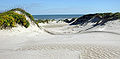
. The island is located on Texas' southern coast of the Gulf of Mexico
Gulf of Mexico
The Gulf of Mexico is a partially landlocked ocean basin largely surrounded by the North American continent and the island of Cuba. It is bounded on the northeast, north and northwest by the Gulf Coast of the United States, on the southwest and south by Mexico, and on the southeast by Cuba. In...
and is famous for its white sand
Sand
Sand is a naturally occurring granular material composed of finely divided rock and mineral particles.The composition of sand is highly variable, depending on the local rock sources and conditions, but the most common constituent of sand in inland continental settings and non-tropical coastal...
y beach
Beach
A beach is a geological landform along the shoreline of an ocean, sea, lake or river. It usually consists of loose particles which are often composed of rock, such as sand, gravel, shingle, pebbles or cobblestones...
es at the south end. It is named after Padre José Nicolás Ballí (c.1770-1829),
who served as collector of finances for all the churches in the Rio Grande Valley
Rio Grande Valley
The Rio Grande Valley or the Lower Rio Grande Valley, informally called The Valley, is an area located in the southernmost tip of South Texas...
and founded the first mission
Spanish missions in Texas
The Spanish Missions in Texas comprise a series of religious outposts established by Spanish Catholic Dominicans, Jesuits, and Franciscans to spread the Christian doctrine among the local Native Americans, but with the added benefit of giving Spain a toehold in the frontier land. The missions...
in present Cameron County
Cameron County, Texas
Cameron County is the southernmost county located in the U.S. state of Texas. In 2010, its population was 406,220. Its county seat is Brownsville. Cameron was founded in 1848...
.
Padre Island is the second largest island by area in the contiguous United States
Contiguous United States
The contiguous United States are the 48 U.S. states on the continent of North America that are south of Canada and north of Mexico, plus the District of Columbia....
, after Long Island
Long Island
Long Island is an island located in the southeast part of the U.S. state of New York, just east of Manhattan. Stretching northeast into the Atlantic Ocean, Long Island contains four counties, two of which are boroughs of New York City , and two of which are mainly suburban...
. It is about 130 miles (209 km) long and 3 km wide, stretching from the city of Corpus Christi
Corpus Christi, Texas
Corpus Christi is a coastal city in the South Texas region of the U.S. state of Texas. The county seat of Nueces County, it also extends into Aransas, Kleberg, and San Patricio counties. The MSA population in 2008 was 416,376. The population was 305,215 at the 2010 census making it the...
, in the north, to the resort community of South Padre Island
South Padre Island, Texas
South Padre Island is a town in Cameron County, Texas, United States. It is part of the Brownsville–Harlingen Metropolitan Statistical Area. It may be included as part of the Brownsville–Harlingen–Raymondville and the Matamoros–Brownsville metropolitan areas. The population was 2,816 at the...
in the south. The island is oriented north-south, with the Gulf of Mexico
Gulf of Mexico
The Gulf of Mexico is a partially landlocked ocean basin largely surrounded by the North American continent and the island of Cuba. It is bounded on the northeast, north and northwest by the Gulf Coast of the United States, on the southwest and south by Mexico, and on the southeast by Cuba. In...
on the east, and Laguna Madre
Laguna Madre
The Laguna Madre extends well into Mexico, to the mouth of the Río Soto la Marina in the state of Tamaulipas. It is separated from the Gulf of Mexico on the east by a number of barrier islands, including Barra Los Americanos, Barra Jesús María, and Barra Soto la Marina, and is bounded on the west...
on the west. The island's northern end connects to Mustang Island
Mustang Island
Mustang Island is a barrier island on the Gulf Coast of Texas in the United States. The island is 18 miles long, stretching from Corpus Christi to Port Aransas. The island is oriented generally northeast-southwest, with the Gulf of Mexico on the east and south, and Corpus Christi Bay on the north...
by roadway. The southern end of the island is separated from Brazos Island
Brazos Island
Brazos Island is a barrier island on the Gulf Coast of Texas in the United States, south of the town of South Padre Island.-History:The island is also known as Brazos Santiago Island, a reference to the port of Brazos Santiago, the first Spanish settlement on the island. Later it became the Port...
by the Brazos Santiago Pass.
The town of South Padre Island is located on its southern end, but the island as a whole is sparsely populated. The central part of the island is preserved in a natural wild state as Padre Island National Seashore
Padre Island National Seashore
Padre Island National Seashore is a National Seashore located on Padre Island off the coast of South Texas. In contrast to South Padre Island , PINS is located on North Padre Island and consists of a long beach where nature is preserved...
. Since 1964, the island has been divided by the artificial Port Mansfield Channel, and as a result, the terms "North Padre Island
North Padre Island
North Padre Island is a barrier island along the coast of Texas. It is located between Padre Island and Mustang Island. Most of the island is in the city of Corpus Christi. North Padre Island is one of the major surf areas on the Texas Gulf Coast....
" and "South Padre Island
South Padre Island
South Padre Island is a barrier island in the U.S. state of Texas. It is located in Cameron County and is a popular vacation destination because the resort city South Padre Island is located on the island. The island itself is considered to have been settled by Padre Jose Nicolas Balli, who had a...
" are often used to refer to the separate portions of the island. Padre Island is located in Cameron
Cameron County, Texas
Cameron County is the southernmost county located in the U.S. state of Texas. In 2010, its population was 406,220. Its county seat is Brownsville. Cameron was founded in 1848...
, Kenedy, Kleberg, Nueces, and Willacy counties.
History
When Padre Ballí owned the island, it was known as the Isla de Santiago land grantLand grant
A land grant is a gift of real estate – land or its privileges – made by a government or other authority as a reward for services to an individual, especially in return for military service...
. (Padre Ballí also owned La Feria grant, the Las Castañas grant, part of the Llano Grande grant, and the Guadalupe grant.) Padre Island had been granted to his grandfather, Nicolás Ballí in 1759, by King Carlos III
Charles III of Spain
Charles III was the King of Spain and the Spanish Indies from 1759 to 1788. He was the eldest son of Philip V of Spain and his second wife, the Princess Elisabeth Farnese...
of Spain
Spain
Spain , officially the Kingdom of Spain languages]] under the European Charter for Regional or Minority Languages. In each of these, Spain's official name is as follows:;;;;;;), is a country and member state of the European Union located in southwestern Europe on the Iberian Peninsula...
, and Padre Ballí requested a clear title to the property in 1827. He was the first person to have the island surveyed and was the first settler who brought families to the island. He also built the first church on the island for the conversion of the Karankawa
Karankawa
Karankawa were a group of Native American peoples, now extinct as a tribal group, who played a pivotal part in early Texas history....
Indians and for the benefit of the settlers. About 26 miles (42 km) north of the island's southern tip, the priest founded the town of El Rancho Santa Cruz de Buena Vista (later known as Lost City), where he also kept cattle, horses, and mules.
Ballí died on April 16, 1829, and was buried near Matamoros
Matamoros, Tamaulipas
Matamoros, officially known as Heroica Matamoros, is a city in the northeastern part of Tamaulipas, in the country of Mexico. It is located on the southern bank of the Rio Grande, directly across the border from Brownsville, Texas, in the United States. Matamoros is the second largest and second...
. Title to the island was granted to him posthumously on December 15, 1829, issued jointly in the name of Padre Ballí and his nephew Juan José Ballí. The priest had requested that half of the island be given to his nephew, who had been helping him there. Juan José (nephew) lived on the island from 1829 until his death in 1853.
Padre Island was one of the eight candidate sites for the first test of an atomic bomb.
Geology

Maine
Maine is a state in the New England region of the northeastern United States, bordered by the Atlantic Ocean to the east and south, New Hampshire to the west, and the Canadian provinces of Quebec to the northwest and New Brunswick to the northeast. Maine is both the northernmost and easternmost...
to Mexico
Mexico
The United Mexican States , commonly known as Mexico , is a federal constitutional republic in North America. It is bordered on the north by the United States; on the south and west by the Pacific Ocean; on the southeast by Guatemala, Belize, and the Caribbean Sea; and on the east by the Gulf of...
. These natural barrier island
Barrier island
Barrier islands, a coastal landform and a type of barrier system, are relatively narrow strips of sand that parallel the mainland coast. They usually occur in chains, consisting of anything from a few islands to more than a dozen...
s act to protect the mainland from the direct onslaught of storms.
Padre Island began forming as a submerged sand bar some 4500 years ago, as shown by radiocarbon dating
Radiocarbon dating
Radiocarbon dating is a radiometric dating method that uses the naturally occurring radioisotope carbon-14 to estimate the age of carbon-bearing materials up to about 58,000 to 62,000 years. Raw, i.e. uncalibrated, radiocarbon ages are usually reported in radiocarbon years "Before Present" ,...
of shells. Geologic speculation indicates the emerged island itself may be 1000 to 1500 years younger. Barrier island origins have been debated for many years by geologist
Geologist
A geologist is a scientist who studies the solid and liquid matter that constitutes the Earth as well as the processes and history that has shaped it. Geologists usually engage in studying geology. Geologists, studying more of an applied science than a theoretical one, must approach Geology using...
s, but it is agreed they are formed and modified by such factors as sediment
Sediment
Sediment is naturally occurring material that is broken down by processes of weathering and erosion, and is subsequently transported by the action of fluids such as wind, water, or ice, and/or by the force of gravity acting on the particle itself....
type and supply, sea-level directional changes, current and wave strength and direction, and tide magnitude.
It is theorized that Padre Island formed from offshore shoal
Shoal
Shoal, shoals or shoaling may mean:* Shoal, a sandbank or reef creating shallow water, especially where it forms a hazard to shipping* Shoal draught , of a boat with shallow draught which can pass over some shoals: see Draft...
s with later growth aided by spit accretion
Accretion (coastal management)
Accretion is the process of coastal sediment returning to the visible portion of a beach or foreshore following a submersion event. A sustainable beach or foreshore often goes through a cycle of submersion during rough weather then accretion during calmer periods...
. (A spit is a long, narrow tongue of sand extending from a mainland shoreline and formed by the shoreline drifting of sediments.) After a history of shifting, abandonment and reestablishment by storm breaches, many tidal inlets were slowly closed and short islands were joined to form today's longer islands.
Padre Island graphically illustrates the life and sequences of a barrier
Barrier island
Barrier islands, a coastal landform and a type of barrier system, are relatively narrow strips of sand that parallel the mainland coast. They usually occur in chains, consisting of anything from a few islands to more than a dozen...
shoreline: accretionary or building phase, equilibrium or stability phase and erosion or destructional state. The northern half of Padre Island's shoreline is in equilibrium; the southern half (and much of the remaining Texas coastline) is in an erosional stage. Wind, wave and current action continue to rework and shape the island. South Padre Island has been in a destructive phase for a long time, probably having retreated landward (along with the lagoon
Lagoon
A lagoon is a body of shallow sea water or brackish water separated from the sea by some form of barrier. The EU's habitat directive defines lagoons as "expanses of shallow coastal salt water, of varying salinity or water volume, wholly or partially separated from the sea by sand banks or shingle,...
and mainland shoreline). All of Padre Island will probably retreat landward through long-term erosion due to three causes: interruption and decrease in sediment supply, relative sea level rise, and tropical storm activity. Today, hurricane washovers and wind-carried sand deposited in the Laguna Madre
Laguna Madre
The Laguna Madre extends well into Mexico, to the mouth of the Río Soto la Marina in the state of Tamaulipas. It is separated from the Gulf of Mexico on the east by a number of barrier islands, including Barra Los Americanos, Barra Jesús María, and Barra Soto la Marina, and is bounded on the west...
build Padre Island's landward side at the expense of the Laguna Madre.
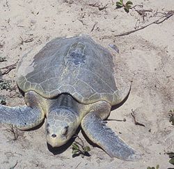
Kemp's Ridley sea turtle
Wildlife
Wildlife includes all non-domesticated plants, animals and other organisms. Domesticating wild plant and animal species for human benefit has occurred many times all over the planet, and has a major impact on the environment, both positive and negative....
officials found a record of 128 Kemp's Ridley
Kemp's Ridley
Kemp's ridley sea turtle , or Atlantic ridley sea turtle is the rarest sea turtle and is critically endangered. It is one of two living species in the genus Lepidochelys Kemp's ridley sea turtle (Lepidochelys kempii), or Atlantic ridley sea turtle is the rarest sea turtle and is critically...
sea turtle
Sea turtle
Sea turtles are marine reptiles that inhabit all of the world's oceans except the Arctic.-Distribution:...
nests on Texas beaches, including 81 in the Padre Island National Seashore and 4 on nearby Mustang Island
Mustang Island
Mustang Island is a barrier island on the Gulf Coast of Texas in the United States. The island is 18 miles long, stretching from Corpus Christi to Port Aransas. The island is oriented generally northeast-southwest, with the Gulf of Mexico on the east and south, and Corpus Christi Bay on the north...
. Wildlife officials released 10,594 Kemp's ridleys hatchlings along the Texas coast
Coast
A coastline or seashore is the area where land meets the sea or ocean. A precise line that can be called a coastline cannot be determined due to the dynamic nature of tides. The term "coastal zone" can be used instead, which is a spatial zone where interaction of the sea and land processes occurs...
in 2007. The turtles are endangered due to shrimpers'
Shrimp
Shrimp are swimming, decapod crustaceans classified in the infraorder Caridea, found widely around the world in both fresh and salt water. Adult shrimp are filter feeding benthic animals living close to the bottom. They can live in schools and can swim rapidly backwards. Shrimp are an important...
nets and they are popular in Mexico as boot
Boot
A boot is a type of footwear but they are not shoes. Most boots mainly cover the foot and the ankle and extend up the leg, sometimes as far as the knee or even the hip. Most boots have a heel that is clearly distinguishable from the rest of the sole, even if the two are made of one piece....
material and food
Food
Food is any substance consumed to provide nutritional support for the body. It is usually of plant or animal origin, and contains essential nutrients, such as carbohydrates, fats, proteins, vitamins, or minerals...
.
See also
- Barrier islandBarrier islandBarrier islands, a coastal landform and a type of barrier system, are relatively narrow strips of sand that parallel the mainland coast. They usually occur in chains, consisting of anything from a few islands to more than a dozen...
- LagoonLagoonA lagoon is a body of shallow sea water or brackish water separated from the sea by some form of barrier. The EU's habitat directive defines lagoons as "expanses of shallow coastal salt water, of varying salinity or water volume, wholly or partially separated from the sea by sand banks or shingle,...
- Laguna MadreLaguna MadreThe Laguna Madre extends well into Mexico, to the mouth of the Río Soto la Marina in the state of Tamaulipas. It is separated from the Gulf of Mexico on the east by a number of barrier islands, including Barra Los Americanos, Barra Jesús María, and Barra Soto la Marina, and is bounded on the west...
- South Padre IslandSouth Padre IslandSouth Padre Island is a barrier island in the U.S. state of Texas. It is located in Cameron County and is a popular vacation destination because the resort city South Padre Island is located on the island. The island itself is considered to have been settled by Padre Jose Nicolas Balli, who had a...
- North Padre IslandNorth Padre IslandNorth Padre Island is a barrier island along the coast of Texas. It is located between Padre Island and Mustang Island. Most of the island is in the city of Corpus Christi. North Padre Island is one of the major surf areas on the Texas Gulf Coast....