
.gif)
Hurricane Jerry (1989)
Encyclopedia
Hurricane Jerry was the tenth named storm and the sixth and final hurricane of the 1989 Atlantic hurricane season
. Jerry was also the fourth U.S. landfalling storm and the third storm to strike Texas
during the 1989 season; the two previous storms were Allison
in June and Chantal
in August. When it hit, it marked the most number of Texas landfalls in one season since 1886. Only four October tropical cyclones have struck and/or caused significant affects along the upper-Texas coast over the past 150 years, which occurs about once every 38 year, with only six having done so in the past 175 years.
Hurricane Jerry more notable for its unpredictability, as it was unexpected that it would continue northwest into the upper Texas coast, with computer models predicting a majority of the United States Gulf Coast was at threat of landfall. Although there was unpredictability and a hurricane warning issued only eight hours before landfall, only three fatalities resulted and $70 million (1989 USD
, $ USD) in property damage.
. The tropical wave decelerated when it reached the Yucatán Peninsula
and stalled for several days in the southern Gulf of Mexico. After reaching the Gulf of Mexico, Dvorak Technique began to estimate intensity of the tropical wave starting on October 12. A later reconnaissance Air Force Flight had discovered a closed circulation at 1900 UTC, classifying the system as Tropical Depression Fourteen; post-storm analysis estimates that a tropical cyclone actually developed at 1200 UTC near the Mexican
port of Veracruz
.
Tropical Depression Fourteen headed northward after development, quickly intensifying into a tropical storm; the National Hurricane Center
assigned it to the name Jerry. Jerry continued northward between five mph (10 km/h) and 10 mph (20 km/h), while gradually intensifying. It decelerated on October 13, in response to a middle to upper-level trough which weakened the steering currents of Tropical Storm Jerry. The middle to upper-level trough generated a cut-low pressure area, which shifted Jerry to the north-northwest. Upper level wind shear on Tropical Storm Jerry in the central Gulf of Mexico, temporarily preventing no further intensification. The upper-level outflow pattern became more apparent, which decreased wind shear on Jerry and resumed strengthening.
After upper-level wind shear decreased, Tropical Storm Jerry began to develop deep convection near the center, and within the following twelve hours, Jerry had attained Category 1 hurricane status. Three hours thereafter, a minimum pressure of 983 mbar (hPa; 29.03 inHg) was reported, the lowest barometric pressure in association with Hurricane Jerry. Based on aircraft reports, Hurricane Jerry quickly deepened between 0800 UTC and 2100 UTC on October 15, although too slow to be considered rapid deepening. Slightly further intensification occurred, and Hurricane Jerry made landfall in Galveston, Texas
at 7:30 p.m. CDT (0300 UTC October 16) with winds of 85 mph (140 km/h). Hurricane Jerry headed north and accelerated after moving inland, also rapidly weakening to a tropical storm less than six hours after landfall. Rapidly weakening continued, although much slower, with Jerry being downgraded to a tropical depression after several more hours. Tropical Depression Jerry was absorbed into a frontal zone later on October 16.
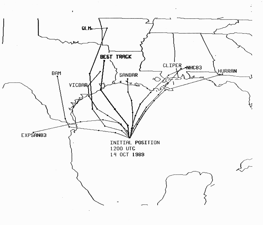 Jerry was an unpredictable storm as the strengthening before landfall and the continuation to the northwest was not anticipated. Equipment failure meant that data was not readily available, resulting in the release of a hurricane warning
only eight hours prior to landfall. The National Hurricane Center forecast model was also disabled, throwing the accuracy of Jerry's track off.
, $ USD) in damage. The landfall of Jerry marked the third landfall on Texas in 1989, after Tropical Storm Allison
and Hurricane Chantal
, the record highest number of tropical cyclone landfalls for Texas
since the 1886 season
.
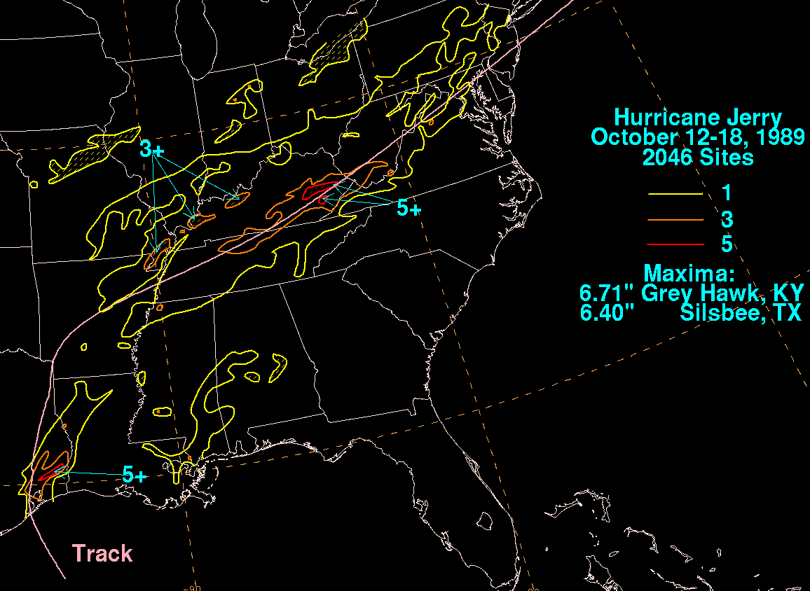 Jerry produced heavy rainfall when it made landfall, with 6.4 inches (160 mm) of rain being reported in Silsbee, Texas
. In Galveston, city officials reported power outages, street flooding, and a roof blown off a building. Three people were killed when their car crashed off the Galveston Seawall
during the storm. It was unknown if the car simply drove off the seawall because of heavy rains or it was blown off by high winds. Jerry also caused light beach erosion along the Texas coast. Hurricane Jerry provided the final destruction of Texas State Highway 87 between High Island
and Sabine Pass
. This section of the highway had become a victim to shoreline erosion and high tides. The twenty mile (32 km) section was destroyed by the hurricane.
Many other states reported rainfall from either Hurricane Jerry or the remnants, although the highest rainfall outside Texas was in Tennessee
and Kentucky
which reported between three-five inches (8–13 cm). The heavy rainfall left many residents isolated in eastern Kentucky after flooding destroyed bridges and roads. According to state disaster assessment teams, hundreds of residents in eastern Kentucky and West Virginia
had flood damage to their houses.
, Bonnie of 1986
and Hurricane Chantal earlier in the season
.
1989 Atlantic hurricane season
The 1989 Atlantic hurricane season was an active season that produced fifteen tropical cyclones, eleven named storms, seven hurricanes, and two major hurricanes. The season was officially designated from June 1, 1989, to November 30, 1989, dates which conventionally...
. Jerry was also the fourth U.S. landfalling storm and the third storm to strike Texas
Texas
Texas is the second largest U.S. state by both area and population, and the largest state by area in the contiguous United States.The name, based on the Caddo word "Tejas" meaning "friends" or "allies", was applied by the Spanish to the Caddo themselves and to the region of their settlement in...
during the 1989 season; the two previous storms were Allison
Tropical Storm Allison (1989)
Tropical Storm Allison was a tropical cyclone that produced severe flooding in the southern United States. The second tropical cyclone and the first named storm of the 1989 Atlantic hurricane season, Allison formed on June 24 in the northwestern Gulf of Mexico. Development of Allison was a result...
in June and Chantal
Hurricane Chantal (1989)
Hurricane Chantal was one of three tropical cyclones to make landfall in Texas during the 1989 Atlantic hurricane season. The third named storm and the first hurricane of the season, Chantal slowly developed on July 30 in the southern Gulf of Mexico from a tropical disturbance within that was...
in August. When it hit, it marked the most number of Texas landfalls in one season since 1886. Only four October tropical cyclones have struck and/or caused significant affects along the upper-Texas coast over the past 150 years, which occurs about once every 38 year, with only six having done so in the past 175 years.
Hurricane Jerry more notable for its unpredictability, as it was unexpected that it would continue northwest into the upper Texas coast, with computer models predicting a majority of the United States Gulf Coast was at threat of landfall. Although there was unpredictability and a hurricane warning issued only eight hours before landfall, only three fatalities resulted and $70 million (1989 USD
United States dollar
The United States dollar , also referred to as the American dollar, is the official currency of the United States of America. It is divided into 100 smaller units called cents or pennies....
, $ USD) in property damage.
Meteorological history
A tropical wave emerged from the coast of northwest Africa on September 23. No additional signs of development were noted as the tropical wave crossed the tropical Atlantic or the Caribbean SeaCaribbean Sea
The Caribbean Sea is a sea of the Atlantic Ocean located in the tropics of the Western hemisphere. It is bounded by Mexico and Central America to the west and southwest, to the north by the Greater Antilles, and to the east by the Lesser Antilles....
. The tropical wave decelerated when it reached the Yucatán Peninsula
Yucatán Peninsula
The Yucatán Peninsula, in southeastern Mexico, separates the Caribbean Sea from the Gulf of Mexico, with the northern coastline on the Yucatán Channel...
and stalled for several days in the southern Gulf of Mexico. After reaching the Gulf of Mexico, Dvorak Technique began to estimate intensity of the tropical wave starting on October 12. A later reconnaissance Air Force Flight had discovered a closed circulation at 1900 UTC, classifying the system as Tropical Depression Fourteen; post-storm analysis estimates that a tropical cyclone actually developed at 1200 UTC near the Mexican
Mexico
The United Mexican States , commonly known as Mexico , is a federal constitutional republic in North America. It is bordered on the north by the United States; on the south and west by the Pacific Ocean; on the southeast by Guatemala, Belize, and the Caribbean Sea; and on the east by the Gulf of...
port of Veracruz
Veracruz, Veracruz
Veracruz, officially known as Heroica Veracruz, is a major port city and municipality on the Gulf of Mexico in the Mexican state of Veracruz. The city is located in the central part of the state. It is located along Federal Highway 140 from the state capital Xalapa, and is the state's most...
.
Tropical Depression Fourteen headed northward after development, quickly intensifying into a tropical storm; the National Hurricane Center
National Hurricane Center
The National Hurricane Center , located at Florida International University in Miami, Florida, is the division of the National Weather Service responsible for tracking and predicting weather systems within the tropics between the Prime Meridian and the 140th meridian west poleward to the 30th...
assigned it to the name Jerry. Jerry continued northward between five mph (10 km/h) and 10 mph (20 km/h), while gradually intensifying. It decelerated on October 13, in response to a middle to upper-level trough which weakened the steering currents of Tropical Storm Jerry. The middle to upper-level trough generated a cut-low pressure area, which shifted Jerry to the north-northwest. Upper level wind shear on Tropical Storm Jerry in the central Gulf of Mexico, temporarily preventing no further intensification. The upper-level outflow pattern became more apparent, which decreased wind shear on Jerry and resumed strengthening.
After upper-level wind shear decreased, Tropical Storm Jerry began to develop deep convection near the center, and within the following twelve hours, Jerry had attained Category 1 hurricane status. Three hours thereafter, a minimum pressure of 983 mbar (hPa; 29.03 inHg) was reported, the lowest barometric pressure in association with Hurricane Jerry. Based on aircraft reports, Hurricane Jerry quickly deepened between 0800 UTC and 2100 UTC on October 15, although too slow to be considered rapid deepening. Slightly further intensification occurred, and Hurricane Jerry made landfall in Galveston, Texas
Galveston, Texas
Galveston is a coastal city located on Galveston Island in the U.S. state of Texas. , the city had a total population of 47,743 within an area of...
at 7:30 p.m. CDT (0300 UTC October 16) with winds of 85 mph (140 km/h). Hurricane Jerry headed north and accelerated after moving inland, also rapidly weakening to a tropical storm less than six hours after landfall. Rapidly weakening continued, although much slower, with Jerry being downgraded to a tropical depression after several more hours. Tropical Depression Jerry was absorbed into a frontal zone later on October 16.
Unpredictability
Tropical cyclone warnings and watches
Warnings and watches are two levels of alert issued by national weather forecasting bodies to coastal areas threatened by the imminent approach of a tropical cyclone of tropical storm or hurricane intensity. They are notices to the local population and civil authorities to make appropriate...
only eight hours prior to landfall. The National Hurricane Center forecast model was also disabled, throwing the accuracy of Jerry's track off.
Impact
Jerry killed three people and caused $70 million dollars (1989 USDUnited States dollar
The United States dollar , also referred to as the American dollar, is the official currency of the United States of America. It is divided into 100 smaller units called cents or pennies....
, $ USD) in damage. The landfall of Jerry marked the third landfall on Texas in 1989, after Tropical Storm Allison
Tropical Storm Allison (1989)
Tropical Storm Allison was a tropical cyclone that produced severe flooding in the southern United States. The second tropical cyclone and the first named storm of the 1989 Atlantic hurricane season, Allison formed on June 24 in the northwestern Gulf of Mexico. Development of Allison was a result...
and Hurricane Chantal
Hurricane Chantal (1989)
Hurricane Chantal was one of three tropical cyclones to make landfall in Texas during the 1989 Atlantic hurricane season. The third named storm and the first hurricane of the season, Chantal slowly developed on July 30 in the southern Gulf of Mexico from a tropical disturbance within that was...
, the record highest number of tropical cyclone landfalls for Texas
Texas
Texas is the second largest U.S. state by both area and population, and the largest state by area in the contiguous United States.The name, based on the Caddo word "Tejas" meaning "friends" or "allies", was applied by the Spanish to the Caddo themselves and to the region of their settlement in...
since the 1886 season
1886 Atlantic hurricane season
The 1886 Atlantic hurricane season ran through the summer and the first half of fall in 1886.-Storms:The 1886 Atlantic hurricane season began with 3 U.S. landfalling hurricanes in June...
.
Silsbee, Texas
Silsbee is a city in Hardin County, Texas, United States. It is located at the intersection of U.S. Highway 96 and State Highway 327. The population was 6,393 at the 2000 census...
. In Galveston, city officials reported power outages, street flooding, and a roof blown off a building. Three people were killed when their car crashed off the Galveston Seawall
Galveston Seawall
The Galveston Seawall is a seawall in Galveston, Texas, USA that was built after the Galveston Hurricane of 1900 for protection from future hurricanes. Construction began in September, 1902, and the initial segment was completed on July 29, 1904. From 1904 to 1963, the seawall was extended from ...
during the storm. It was unknown if the car simply drove off the seawall because of heavy rains or it was blown off by high winds. Jerry also caused light beach erosion along the Texas coast. Hurricane Jerry provided the final destruction of Texas State Highway 87 between High Island
High Island, Texas
High Island is an unincorporated area located in the Bolivar Peninsula census-designated place, Galveston County, Texas, United States. The community is located in the extreme eastern part of the county on Bolivar Peninsula, less than one mile from Chambers County and less than two miles from...
and Sabine Pass
Sabine Pass
Sabine Pass is the natural outlet of Sabine Lake into the Gulf of Mexico. It borders Jefferson County, Texas, and Cameron Parish, Louisiana.Two major battles occurred here during the American Civil War, known as the First and Second Battles of Sabine Pass....
. This section of the highway had become a victim to shoreline erosion and high tides. The twenty mile (32 km) section was destroyed by the hurricane.
Many other states reported rainfall from either Hurricane Jerry or the remnants, although the highest rainfall outside Texas was in Tennessee
Tennessee
Tennessee is a U.S. state located in the Southeastern United States. It has a population of 6,346,105, making it the nation's 17th-largest state by population, and covers , making it the 36th-largest by total land area...
and Kentucky
Kentucky
The Commonwealth of Kentucky is a state located in the East Central United States of America. As classified by the United States Census Bureau, Kentucky is a Southern state, more specifically in the East South Central region. Kentucky is one of four U.S. states constituted as a commonwealth...
which reported between three-five inches (8–13 cm). The heavy rainfall left many residents isolated in eastern Kentucky after flooding destroyed bridges and roads. According to state disaster assessment teams, hundreds of residents in eastern Kentucky and West Virginia
West Virginia
West Virginia is a state in the Appalachian and Southeastern regions of the United States, bordered by Virginia to the southeast, Kentucky to the southwest, Ohio to the northwest, Pennsylvania to the northeast and Maryland to the east...
had flood damage to their houses.
Aftermath
In Polk County, Texas, Jerry knocked out power for five to ten days to half of the residents. Trees were downed everywhere, blocking roads and destroying area homes. Jerry became only the fourth storm to hit this area directly since 1983, the others being Alicia of 1983Hurricane Alicia
Hurricane Alicia was the costliest tropical cyclone in the Atlantic since Hurricane Agnes in 1972. Alicia was the third depression, the first tropical storm, and the only major hurricane of the 1983 Atlantic hurricane season...
, Bonnie of 1986
Hurricane Bonnie (1986)
Hurricane Bonnie was the second named storm, and first hurricane of the 1986 Atlantic hurricane season. Forming on June 23, Bonnie developed out of an area of low pressure over the central Gulf of Mexico. The system gradually intensified and was declared Tropical Storm Bonnie the next day as...
and Hurricane Chantal earlier in the season
Hurricane Chantal (1989)
Hurricane Chantal was one of three tropical cyclones to make landfall in Texas during the 1989 Atlantic hurricane season. The third named storm and the first hurricane of the season, Chantal slowly developed on July 30 in the southern Gulf of Mexico from a tropical disturbance within that was...
.
See also
- Other storms of the same nameHurricane JerryThe name Jerry has been used for four tropical cyclones in the Atlantic Ocean.* 1989's Hurricane Jerry - crossed over the Yucatán as a depression, strengthened and struck Texas, killing three and causing $35 million in damages....
- List of Texas hurricanes