

Huamelulpan (archaeological site)
Encyclopedia
| Mixtec Culture – Archaeological Site | ||
| Name: | Archaeological Site Huamelulpan | |
| Type | Mesoamerican archaeology | |
| Location | San Martín Huamelulpan San Martín Huamelulpan San Martín Huamelulpan is a town in the State of Oaxaca, Mexico, but it is better known simply as Huamelulpan. It is located just off Federal Highway 190. It is a small community of only 250 people whose main occupation is subsistence farming and fruit orchards... , Oaxaca Oaxaca Oaxaca , , officially Estado Libre y Soberano de Oaxaca is one of the 31 states which, along with the Federal District, comprise the 32 federative entities of Mexico. It is divided into 571 municipalities; of which 418 are governed by the system of customs and traditions... |
|
| Region | Mesoamerica Mesoamerica Mesoamerica is a region and culture area in the Americas, extending approximately from central Mexico to Belize, Guatemala, El Salvador, Honduras, Nicaragua, and Costa Rica, within which a number of pre-Columbian societies flourished before the Spanish colonization of the Americas in the 15th and... |
|
| Coordinates | 17°33′02"N 97°24′58"W | |
| Culture | Mixtec Mixtec The Mixtec are indigenous Mesoamerican peoples inhabiting the Mexican states of Oaxaca, Guerrero and Puebla in a region known as La Mixteca. The Mixtecan languages form an important branch of the Otomanguean language family.... (Lower) |
|
| Language | Mixtec Mixtecan languages The Mixtec language, actually multiple languages, belong to Otomanguean language family of Mexico, and are closely related to the Trique and Cuicatec languages. They are spoken by over half a million people. Identifying how many Mixtec languages there are in this complex dialect continuum poses... |
|
| Chronology | 400 BCE to 800 CE | |
| Period | Mesoamerican Preclassical, Classical and Postclassical (Ramos Phase) | |
| Apogee | 300 BCE – 200 CE | |
| INAH Web Page | Huamelulpan Archaeological Site |
|
Huamelulpan is an archaeological site of the Mixtec
Mixtec
The Mixtec are indigenous Mesoamerican peoples inhabiting the Mexican states of Oaxaca, Guerrero and Puebla in a region known as La Mixteca. The Mixtecan languages form an important branch of the Otomanguean language family....
culture, located in the town of San Martín Huamelulpan
San Martín Huamelulpan
San Martín Huamelulpan is a town in the State of Oaxaca, Mexico, but it is better known simply as Huamelulpan. It is located just off Federal Highway 190. It is a small community of only 250 people whose main occupation is subsistence farming and fruit orchards...
at an elevation of 2218 metres (7,276.9 ft), about 96 kilometres (59.7 mi) north-west of the city of Oaxaca
Oaxaca, Oaxaca
The city and municipality of Oaxaca de Juárez, or simply Oaxaca, is the capital and largest city of the Mexican state of the same name . It is located in the Centro District in the Central Valleys region of the state, in the foothills of the Sierra Madre at the base of the Cerro del Fortín...
, the capital of Oaxaca
Oaxaca
Oaxaca , , officially Estado Libre y Soberano de Oaxaca is one of the 31 states which, along with the Federal District, comprise the 32 federative entities of Mexico. It is divided into 571 municipalities; of which 418 are governed by the system of customs and traditions...
state.
Because of its dimensions it must have been one of the largest Mesoamerica
Mesoamerica
Mesoamerica is a region and culture area in the Americas, extending approximately from central Mexico to Belize, Guatemala, El Salvador, Honduras, Nicaragua, and Costa Rica, within which a number of pre-Columbian societies flourished before the Spanish colonization of the Americas in the 15th and...
n cities of its time, and also one with the longest occupation, from the Preclassic to the Postclassic Periods
Mesoamerican chronology
Mesoamerican chronology divides the history of pre-Columbian Mesoamerica into several periods: the Paleo-Indian , the Archaic , the Preclassic , the Classic , and the Postclassic...
. The apogee of the settlement is estimated at the Ramos Phase (300 BCE – 200 CE), the period of Mesoamerican urban society’s development.
The site was part of other early settlements in the region, such as Cerro de las Minas
Cerro de las Minas
Cerro de la Minas is an archaeological site located in the modern state of Oaxaca, just to the north of the city of Huajuapan de León. The site belongs to what is called the Ñuiñe, or lowland/hot lands Mixtec cultural area...
, Yucuita
Yucuita
Yucuita is an archaeological site located in the Mixtec municipality of San Juan Yucuita in the Mexican state of Oaxaca...
, Diquiyú and Monte Negro
Monte Negro
Monte Negro is a municipality located in the Brazilian state of Rondônia. Its population was 16,233 and its area is 1,931 km²....
. Their apogee is characterized by monumental architecture and sculptures
Monumental sculpture
The term monumental sculpture is often used in art history and criticism, but not always consistently. It combines two concepts, one of function, and one of size, and may include an element of a third more subjective concept. It is often used for all sculptures that are large...
, there is also evidence of clear social stratification within their residential zones.
During site investigations many high quality urns were found here, similar Zapotec
Zapotec civilization
The Zapotec civilization was an indigenous pre-Columbian civilization that flourished in the Valley of Oaxaca of southern Mesoamerica. Archaeological evidence shows their culture goes back at least 2500 years...
samples were found in the central valleys. Carved monoliths were found at the site, these are considered to be unique since none have been found at other Mixtec urban centers that have such similarity to the Zapotec writing of Monte Albán
Monte Albán
Monte Albán is a large pre-Columbian archaeological site in the Santa Cruz Xoxocotlán Municipality in the southern Mexican state of Oaxaca...
.
History
The foundation of this ancient prehispanic city goes back to 400 BCE, it was an important urban center up to 800 CE; it is a good sample of the early Mixtec culture, called Ñuu Sa Na or “Ancient People” (Ñuu Yata in the Mixteca BajaLa Mixteca
La Mixteca is a cultural, economic and political region that covers parts of the states of Puebla, Guerrero and Oaxaca in south-central Mexico....
).
During their early urban stages, Huamelulpan and the main Mixtec centers maintained complex and variable relations with Monte Alban. Towards 200 CE, some Mixtec centers were partially or totally abandoned and between 400 and 800 CE, there was another urban center boom, when Huamelulpan and other sites lost their close relationships with Monte Alban and established new relations with Lower Mixtec centers linked with groups from Puebla and perhaps the Valley of Mexico
Valley of Mexico
The Valley of Mexico is a highlands plateau in central Mexico roughly coterminous with the present-day Distrito Federal and the eastern half of the State of Mexico. Surrounded by mountains and volcanoes, the Valley of Mexico was a centre for several pre-Columbian civilizations, including...
. The Lower Mixtec (Ñuiñe) culture developed at this time. The city was abandoned by the Postclassic and it was only used for sumptuary burials.
According to archaeological history, the site was a very important Mixtec center, where tributes were received, to be traded with Puebla
Puebla
Puebla officially Estado Libre y Soberano de Puebla is one of the 31 states which, with the Federal District, comprise the 32 Federal Entities of Mexico. It is divided in 217 municipalities and its capital city is Puebla....
, Tehuacán
Tehuacán
Tehuacán is the second largest city in the Mexican state of Puebla, nestled in the Southeast Valley of Tehuacán, bordering the states of Oaxaca and Veracruz. The 2010 census reported a population of 248,716 in the city and 274,906 in its surrounding municipality of the same name, of which it serves...
and all of Oaxaca to the Pacific coast; from Tehuacán and Puebla traded fabrics and yarns, from the coast traded chilies, Jamaica, jicaras
Crescentia cujete
Crescentia cujete, commonly known as the Calabash Tree, is species of flowering plant that is native to Central and South America. It is a dicotyledonous plant with tripinnate leaves...
, dried fish, salt, sea shells used for necklaces, earrings, etc.
Ancient Huamelulpan had important weapon and fur workshops.
Discovery
The Huamelulpan archaeological site was discovered in 1933 by Alfonso Caso and many of the pieces found are in exhibition at the Town Community Museum.Toponymy
The name Huamelulpan comes from the Nahuatl language, a language that was not spoken by the original inhabitants. Its Nahuatl name means "In the huautli mound", the Mixtec name is Yucunindaba, and it means “Hill that flew”.Jansen y Pérez Jimenez offer an alternative opinion, that the native name is Yucunundaua, which translates “Hill of the Wooden Columns”.
According to the Mexico Municipalities Encyclopedia, the name Huamelulpam was developed from two huamil trees that grew together and formed a letter (h), the story goes that these trees lasted for centuries, and the town was called Huamelulpam.
Mixtec Phases
The Alta-Mixteca region development has been segregated into various phases; Cruz, Ramos, Las Flores and Natividad, that covers the region development from about 1500 BCE to 1530 CE.Cruz-Ramos transition. During the transition from the mid-formative period (Late Cruz) to the late- formative (Early Ramos) the number of sites decreased in the studied area.
It is considered a consequence of the development of early Mixtec urban centers – a process observed elsewhere in Oaxaca – the Central Valleys, the Huamelulpan Valley, and the Eastern Nochixtlán Valley. Two of the Early Ramos sites – Monte Negro and Cerro Jazmin – were already urban centers covering more than one km2.
There is an apparent absence of settlements dating to the Late Ramos (200 B.C.-200 A.D.) in the major part of the area surveyed (only 15 sites, 170 ha comparing to 62 sites and 700 ha of Early Ramos). It is a striking fact because in Yucuita and Huamelulpan this period was a time of the major centralization and florescence of the regional states and general growth of the population. At the same time only two sites in the surveyed area had continuous occupation from Early Ramos to Early Flores while 20 had a gap between these phases.
| Phase | Chronnology | Tlaxiaco | Teposcolula | Nochixtlán | Total | |
|---|---|---|---|---|---|---|
| Cruz | 1500–300 BCE | 47 Sites | 40 Sites | 29 Sites | 116 Sites | |
| Ramos | 300 BCE – 200 CE | 41 Sites | 27 Sites | 10 Sites | 78 Sites | |
| Las Flores | 200–1000 CE | 92 Sites | 67 Sites | 49 Sites | 208 Sites | |
| Natividad | 1000–1530 CE | 199 Sites | 179 Sites | 88 Sites | 466 Sites | |
| Regional survey in the Central Mixteca Alta, Oaxaca, México. Conducted between January 1 and June 15, 1999. | ||||||
Mixtec Culture
The Mixtec (or Mixteca) are indigenous MesoamericaMesoamerica
Mesoamerica is a region and culture area in the Americas, extending approximately from central Mexico to Belize, Guatemala, El Salvador, Honduras, Nicaragua, and Costa Rica, within which a number of pre-Columbian societies flourished before the Spanish colonization of the Americas in the 15th and...
n peoples inhabiting the Mexican states of Oaxaca
Oaxaca
Oaxaca , , officially Estado Libre y Soberano de Oaxaca is one of the 31 states which, along with the Federal District, comprise the 32 federative entities of Mexico. It is divided into 571 municipalities; of which 418 are governed by the system of customs and traditions...
, Guerrero
Guerrero
Guerrero officially Estado Libre y Soberano de Guerrero is one of the 31 states which, with the Federal District, comprise the 32 Federal Entities of Mexico. It is divided in 81 municipalities and its capital city is Chilpancingo....
and Puebla
Puebla
Puebla officially Estado Libre y Soberano de Puebla is one of the 31 states which, with the Federal District, comprise the 32 Federal Entities of Mexico. It is divided in 217 municipalities and its capital city is Puebla....
in a region known as La Mixteca
La Mixteca
La Mixteca is a cultural, economic and political region that covers parts of the states of Puebla, Guerrero and Oaxaca in south-central Mexico....
. The Mixtecan languages
Mixtecan languages
The Mixtec language, actually multiple languages, belong to Otomanguean language family of Mexico, and are closely related to the Trique and Cuicatec languages. They are spoken by over half a million people. Identifying how many Mixtec languages there are in this complex dialect continuum poses...
form an important branch of the Otomanguean language family.
The name "Mixtec" is a Nahuatl
Nahuatl
Nahuatl is thought to mean "a good, clear sound" This language name has several spellings, among them náhuatl , Naoatl, Nauatl, Nahuatl, Nawatl. In a back formation from the name of the language, the ethnic group of Nahuatl speakers are called Nahua...
exonym, from miʃ 'cloud' teka 'inhabitant of place of'. Speakers of Mixtec use an expression (which varies by dialect) to refer to their own language, and generally this expression means "word of the rain": Tu'un Sávi [tũˀũ saβi] in one variety, for example, and Dà'àn Dávi [ðãˀã ðaβi] in another.
Mixtec Language
The Mixtecan languages constitute a branch of the Otomanguean language family of MexicoMexico
The United Mexican States , commonly known as Mexico , is a federal constitutional republic in North America. It is bordered on the north by the United States; on the south and west by the Pacific Ocean; on the southeast by Guatemala, Belize, and the Caribbean Sea; and on the east by the Gulf of...
. The Mixtecan branch includes the Trique
Trique language
The Trique language is an Oto-Manguean language of Mexico spoken by the Trique indigenous group of the state of Oaxaca and elsewhere...
(or Triqui) languages, spoken by about 24,500 people; Cuicatec
Cuicatec
The Cuicatecs are an indigenous group of the Mexican state of Oaxaca, closely related to the Mixtecs. They inhabit two towns: Teutila and Tepeuxila in western Oaxaca...
, spoken by about 15,000 people; and the large group of Mixtec languages proper, spoken by about 511,000 people. Again, the Mixtec languages proper are a grouping within the Mixtecan branch of the Otomanguean family. Virtually all of the remainder of this article is about Mixtec proper; for Cuicatec and Trique, see the separate articles. The internal classification of the Mixtecan branch, i.e., the subgrouping between Trique, Cuicatec, and Mixtec proper, is an open question. As to the Mixtec languages proper, identifying how many there are poses challenges at the level of linguistic theory. Depending on the criteria for distinguishing between a difference of dialects and a difference of languages, there may be as many as 50 different Mixtec languages
Language, codices, and artwork
The Mixtecan languagesMixtecan languages
The Mixtec language, actually multiple languages, belong to Otomanguean language family of Mexico, and are closely related to the Trique and Cuicatec languages. They are spoken by over half a million people. Identifying how many Mixtec languages there are in this complex dialect continuum poses...
(in their many variants) were estimated to be spoken by about 300,000 people at the end of the 20th century, although the majority of Mixtec speakers also had at least a working knowledge of the Spanish language
Spanish language
Spanish , also known as Castilian , is a Romance language in the Ibero-Romance group that evolved from several languages and dialects in central-northern Iberia around the 9th century and gradually spread with the expansion of the Kingdom of Castile into central and southern Iberia during the...
. Some Mixtecan languages are called by names other than Mixtec, particularly Cuicatec
Cuicatec
The Cuicatecs are an indigenous group of the Mexican state of Oaxaca, closely related to the Mixtecs. They inhabit two towns: Teutila and Tepeuxila in western Oaxaca...
(Cuicateco), and Triqui (or Trique).

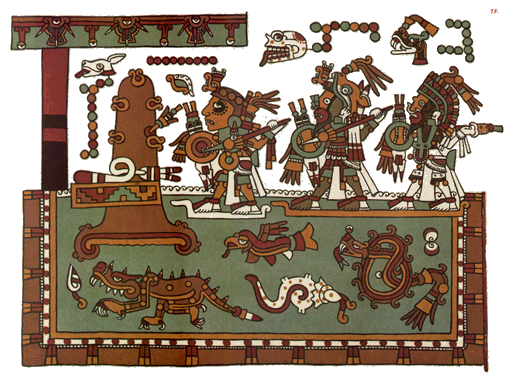
Eight Deer Jaguar Claw
Eight Deer Jaguar Claw was a powerful Mixtec ruler in 11th century Oaxaca referred to in the 15th century deerskin manuscript Codex Zouche-Nuttall, and other Mixtec manuscripts. His surname is alternatively translated Tiger-Claw and Ocelot-Claw. John Pohl has dated his life as having lasted from...
, named after the day in which he was born, whose personal name is Jaguar Claw
Eight Deer Jaguar Claw
Eight Deer Jaguar Claw was a powerful Mixtec ruler in 11th century Oaxaca referred to in the 15th century deerskin manuscript Codex Zouche-Nuttall, and other Mixtec manuscripts. His surname is alternatively translated Tiger-Claw and Ocelot-Claw. John Pohl has dated his life as having lasted from...
, and whose epic history is related in several codices, including the Codex Bodley
Codex Bodley
The Codex Bodley is an important pictographic manuscript, and example of the native Mixtec historiography. It was named after the colloquial name of the Bodleian Library, where it has been stored since the 17th century...
and Codex Zouche-Nuttall
Codex Zouche-Nuttall
The Codex Zouche-Nuttall is an accordion-folded pre-Columbian piece of Mixtec writing, now in the British Museum . It is one of three codices that record the genealogies, alliances and conquests of several 11th and 12th-century rulers of a small Mixtec city-state in highland Oaxaca, the Tilantongo...
. He successfully conquered and united most of the Mixteca region.

Mixtec writing
Pre-Columbian
The pre-Columbian era incorporates all period subdivisions in the history and prehistory of the Americas before the appearance of significant European influences on the American continents, spanning the time of the original settlement in the Upper Paleolithic period to European colonization during...
Mixtec
Mixtec
The Mixtec are indigenous Mesoamerican peoples inhabiting the Mexican states of Oaxaca, Guerrero and Puebla in a region known as La Mixteca. The Mixtecan languages form an important branch of the Otomanguean language family....
codices. The arrival of Europeans in 1520 CE caused changes in form, style, and the function of the Mixtec writings. Today these codices and other Mixtec writings are used as a source of ethnographic, linguistic
Linguistics
Linguistics is the scientific study of human language. Linguistics can be broadly broken into three categories or subfields of study: language form, language meaning, and language in context....
, and historical information for scholars, and help to preserve the identity of the Mixtec people as migration and globalization
Globalization
Globalization refers to the increasingly global relationships of culture, people and economic activity. Most often, it refers to economics: the global distribution of the production of goods and services, through reduction of barriers to international trade such as tariffs, export fees, and import...
introduce new cultural influences.
The Site
The archaeological site includes two sets of terraces, arranged in the slope of a hill. The first set has platforms with slopped walls, stairway, hydraulic system and stands with carved numerals. The second group is integrated by two platforms, formed by rectangular structures with slopped walls and stucco remains. In addition to these groups, there are several tombs and mounds not yet explored.Structures
The main structures of this group are oriented to the west and include: a large square platform, with a central plaza and knolls in three sides; a large terrace or Plaza 2 with an altar; and a ballgame court I shaped, 70 meters long. The explorations in the residential zones produced findings of tombs and burials with ceramics and other offerings.There are five main sets at the site, each with several structures.
Cerro Volado
This group is formed by two large plazas with a mound in the center; others of smaller size are dispersed in the plazas.Pantheon Group
The group is located to the foot of the “Cerro Volado” and has four low platforms around a patio.Old Church
The group is made up by two badly damaged platforms, with a housing area located between this group and the Pantheon.The Church Group is the largest; it is a hill terrace east of the center of the municipality, with old constructions in its slopes and on which a modern day church was built with stones removed from the ancient constructions, these can be seen embedded in its walls with visible carved characters.
Western Group
The group west of the Church has several platforms constructed at different levels.Regional communication
Iconographic similarities shared by Guatemala and Mexican stone sculptures, establish a trade pattern and the need for a route network. Based on archaeological and ethno historical study in eastern Guerrero since 1998, an important network of roads through the Sierra Madres of Guerrero connected the settlements in Morelos and Puebla to the Pacific Coast communication and trade route.It is certain this route played a critical role in the political and economic development of southern Mesoamerica, although its importance varied over time.
There was material and information trade between the Mexico Central Plateau, the Gulf of Mexico and the Pacific Ocean, it is not certain whether it was made through direct contact (15 day or more trips and 15 days to return) or by indirect means (trading goods from community to community, without the high land people ever seeing coastal people).
Roads
Routes from the Gulf of Mexico Mountains and the center of Oaxaca seem to have been constantly open to circulation, since at least the early preclassical period; the Pacific route was apparently blocked at different points, between Chiapas and Oaxaca, for example, during the postclassical period by the Mixtec kingdom of Tututepec on the eve of the Spanish Conquest. One group of epiclassical sculptures indicates iconographic relationships between Morelos and Guerrero, with examples found in Pacific Coastal Chiapas and Guatemala.According to Fray Bernardino de Sahagún (1989:267) Mesoamerica prehispanic roads were simple compacted dirt paths, full of stone and limited by surrounding vegetation. Today these roads have disappeared, whether by railway or asphalt roads and freeways or by abandonment at prehispanic times, in addition to normal erosion deterioration, sedimentation and invasion of adjacent vegetation.
Systematic archaeological and ethnic-historical studies in eastern Guerrero from 1998, have demonstrated the existence of an important road network through the mountain ranges of Guerrero, that connected archaeological sites of Morelos and the south of Puebla with a communication and commerce trade route throughout the Pacific Ocean coast. See Figures 1 and 2
Historical Routes
Without taking into consideration branches and secondary deviations, there are several routes identified, that connected the center of Mexico with the Guatemala Pacific Coast, one through Puebla and the sierra, and the other through the Guerrero state and the Pacific Ocean coast. Both joined at JuchitánJuchitán de Zaragoza
Juchitán de Zaragoza is an indigenous town in the southeast of the Mexican state of Oaxaca.It is part of the Juchitán District in the west of the Istmo de Tehuantepec region...
. From Juchitán, again, there were two routes to Guatemala, one on the north that lead to MIxco-Kalimanjuyu and the other on the south that lead to Escuintla.
North Route Tenochtitlan – Juchitán
The route left Tenochtitlan to Puebla, CholulaCholula
Cholula is a city and district located in the center west of the state of Puebla, next to the city of Puebla de Zaragoza, in central Mexico. Cholula is best known for its Great Pyramid, with the Nuestra Señora de los Remedios sanctuary on top and its numerous churches...
(Tlaxcala Plateau), Orizaba and down to the “Eastern Sierra Madre
Sierra Madre Oriental
The Sierra Madre Oriental is a mountain range in northeastern Mexico.-Setting:Spanning the Sierra Madre Oriental runs from Coahuila south through Nuevo León, southwest Tamaulipas, San Luis Potosí, Querétaro, and Hidalgo to northern Puebla, where it joins with the east-west running Eje Volcánico...
” range to Tuxtepec, Matias Romero and from there, towards the Isthmus.
An alternate route from Cholula went southwards, towards Tehuacán, Oaxaca, Monte Alban and down to Juchitán.
Middle Route Tenochtitlan – Juchitán
This route crosses through Oaxaca had two alternatives:- Via de TehuacánTehuacánTehuacán is the second largest city in the Mexican state of Puebla, nestled in the Southeast Valley of Tehuacán, bordering the states of Oaxaca and Veracruz. The 2010 census reported a population of 248,716 in the city and 274,906 in its surrounding municipality of the same name, of which it serves...
Valley, through the Cuicatlán and TeotitlánCañada, OaxacaCañada is a region in the state of Oaxaca, Mexico covering 4,300 square km. It includes two districts, Teotitlán and Cuicatlán.The main administrative center is Teotitlan de Flores Magon, but Huautla de Jimenez is considered the most important cultural center in the region.The region is named after...
Ravine
- Through the MorelosMorelosMorelos officially Estado Libre y Soberano de Morelos is one of the 31 states which, with the Federal District, comprise the 32 Federal Entities of Mexico. It is divided in 33 municipalities and its capital city is Cuernavaca....
Valley and then through the Lower Mixteca, Huajuapan de LeónHuajuapan de leonHeroica Ciudad de Huajuapan de León; in , meaning Place of Brave People) is a rural city with a surrounding municipality located in the northwestern part of the Mexican state of Oaxaca....
; as well as Mixteca AltaLa MixtecaLa Mixteca is a cultural, economic and political region that covers parts of the states of Puebla, Guerrero and Oaxaca in south-central Mexico....
, Yanhuitlán and Nochistlán.
From the Oaxaca central valleys the route went towards Nejapa, Tequisistlán, and arrived at Tehuantepec
Tehuantepec
Tehuantepec is a city and municipality in the southeast of the Mexican state of Oaxaca. It is part of the Tehuantepec District in the west of the Istmo Region. The area was important in pre Hispanic period as part of a trade route that connected Central America with what is now the center of...
, then Juchitán. and.
South Route Tenochtitlan – Juchitán
This route started at Tenochtitlan, south to Morelos, ChalcatzingoChalcatzingo
Chalcatzingo is a Mesoamerican archaeological site in the Valley of Morelos dating from the Formative Period of Mesoamerican chronology. The site is well-known for its extensive array of Olmec-style monumental art and iconography. Located in the southern portion of the Central Highlands of Mexico,...
and headed east towards the state of Guerrero, passing through Chiautla
Chiautla de Tapia
Chiautla de Tapia is a city and municipality located in the southwestern Mixteca Baja region in the state of Puebla, México.The municipality of Chiautla has a surface area of 685.05 km² which makes it the largest municipality in the state of Puebla....
, Huamuxtitlán
Huamuxtitlán
Huamuxtitlán is a city and seat of the municipality of Huamuxtitlán, in the state of Guerrero, south-western Mexico....
, Tlapa
Tlapa de Comonfort
Tlapa de Comonfort, often shortened to Tlapa and known as Tinda'i in Mixtec, is a city in the mountain region of the Mexican state of Guerrero. It also serves as the municipal seat for the surrounding municipality of the same name....
and Ometepec
Ometepec
Ometepec is a city and seat of the municipality of Ometepec, in the state of Guerrero, south-western Mexico....
, from there headed towards the “Sierra Madre del Sur
Sierra Madre del Sur
The Sierra Madre del Sur is a mountain range in southern Mexico, extending from southern Michoacán east through Guerrero, to the Istmo de Tehuantepec in eastern Oaxaca.-Geography:...
” and the coast, via Tututepec and Huatulco
Huatulco
Huatulco , centered on the town of La Crucecita, is a tourist development in Mexico. It is located on the Pacific coast in the state of Oaxaca. Huatulco's tourism industry is centered on its nine bays thus the name Bahias de Huatulco but has since been unofficially shortened to simply Huatulco...
all the way up to Tehuantepec.
Route Juchitán to Guatemala
From Juchitán to Guatemala there were two routes, north and south.- The northern route, went from Juchitán to TapanatepecSan Pedro TapanatepecSan Pedro Tapanatepec is a town and municipality in Oaxaca in south-western Mexico. It is part of the Juchitán District in the west of the Istmo de Tehuantepec region.The town was founded on 23 April 1669, and became a municipality on March 15, 1825....
and then towards “Chiapa de los Indios” (Chiapa de CorzoChiapa de CorzoChiapa de Corzo may refer to:*Chiapa de Corzo - a Mesomerican archaeological site located in the Chiapas highlands, Mexico*Chiapa de Corzo, Chiapas - the modern township and municipality, central Chiapas, Mexico...
) and headed towards Comitán and then, in Guatemalan territory, onto HuehuetenangoHuehuetenangoHuehuetenango is a city and a municipality in the highlands of western Guatemala. It is also the capital of the department of Huehuetenango. The municipality's population was over 81,000 people in 2002...
, QuetzaltenangoQuetzaltenangoQuetzaltenango, also commonly known by its indigenous name, Xelajú , or more commonly, Xela , is the second largest city of Guatemala. It is both the capital of Quetzaltenango Department and the municipal seat of Quetzaltenango municipality....
, ChimaltenangoChimaltenangoChimaltenango is a town in Guatemala of some 43,900 people . It serves as both the capital of the department of Chimaltenango and the municipal seat for the surrounding municipality of the same name....
and Mixco ViejoMixco ViejoMixco Viejo is an archaeological site in the north east of the Chimaltenango department of Guatemala, some 50 km to the north of Guatemala City and 4km from the junction of the rivers Pixcaya and Motagua...
.
- The southern Isthmus or Soconusco route continued from TapanatepecSan Pedro TapanatepecSan Pedro Tapanatepec is a town and municipality in Oaxaca in south-western Mexico. It is part of the Juchitán District in the west of the Istmo de Tehuantepec region.The town was founded on 23 April 1669, and became a municipality on March 15, 1825....
to TonaláTonalá, ChiapasTonalá is a town and one of the 119 Municipalities of Chiapas, in southern Mexico.As of 2005, the municipality had a total population of 78,438. It covers an area of 1766.2 km²....
, PijijiapanPijijiapanPijijiapan is a town and municipality in the Mexican state of Chiapas, on the coast of the Pacific Ocean about midway between the border with the state of Oaxaca and the international frontier with Guatemala. Pijijiapan reported a 2005 census population of 46,949 persons. It has a land area of...
, Tuxtla Chico, and then in Guatemalan territory, onto RetalhuleuRetalhuleuThe city of Retalhuleu is in south-western Guatemala. It is the departmental seat of Retalhuleu department as well as the municipal seat of Retalhuleu municipality....
and down to Santa Lucia CotzumalguapaSanta Lucía CotzumalguapaSanta Lucía Cotzumalguapa is a municipality in the Escuintla department of Guatemala.The municipality includes the pre-Columbian archaeological sites of El Baúl and Bilbao....
, EscuintlaEscuintlaEscuintla is a city in south central Guatemala. It is the capital of the Escuintla Department and the administrative seat of Escuintla Municipality....
.
In spite of the importance of these routes, passage through these routes was blocked by the Mixtec Kingdom of Tututepec, that monopolized it for their own benefit and caused tensions with the political groups of the Mexican Plateau, especially with the Triple Alliance.
Regional relations and commerce
There are numerous evidences of regional trade from northwestern mesoamerican civilizations, the Mexican highlands and Centro America with southern lands as far down as Peru and Colombia, some of which are suspected but remain a strong possibility, based on evidences. Certainly, it is elemental understanding how people traveled and traded.As early as 1881, Carl Bovallius Swedish archaeologist and investigator exploring Central America (Ometepe
Ometepe (archaeological site)
Ometepe Island is an important archaeological site, located in the Lake Nicaragua in the Republic of Nicaragua, administratively belongs to the Rivas Department...
and Zapatera
Zapatera (archaeological site)
Zapatera is an archaeological site located on Isla Zapatera, a volcanic island in Lake Nicaragua, Granada Department, Nicaragua. The large quantity of statues, petroglyphs and pottery found at the site, and on other islands in the Zapatera archipelago, suggests the area was an important ceremonial...
), noted: “Los Orotinas far separated from their relations, inhabiting the peninsula of Nicoya and the territory of Guanacaste, which com¬prises the north-eastern part of the republic of Costa Rica. Opinions vary, however, with regard to these groups, several authors being inclined to regard los Cholutecas as a detached branch of los Pipiles in El Salvador; they would then be of Toltecan origin. Certainly there are a number of local names within their district which seem to corroborate this opinion.”
According to Bovallius, other writers are disposed to ascribe a Mexican origin to the Orotinas and lastly Dr. Berendt suggests that the whole Chorotegan stock may be considered as a Toltecan offspring, the name Choroteganos being only a corruption of Cholutecas. According to the concurrent testimonies of the old chroniclers the Niquirans were a Mexican people settled in the country at a comparatively late period. It is not clear whether they were Toltecs or Aztecs, and this question cannot probably be decided until the ancient remains, surely very numerous, that they have left behind them, shall have been accurately studied and com¬pared with the better known Mexican antiquities. The intelligent and well-built Indians on the island of Ometepec are doubtless the descendants of the Niquirans; this is corroborated by their language, which the successful investigations of SQUIER have shown to be of Mexican origin and presenting a very close similarity to the pure Aztec tongue. (Written in 1886)
An elemental piece of this discussion was provided by Bernal Diaz del Castillo, who mentioned that once they took over Tenochtitlan (1521 CE), lords from Tehuantepec came before Cortes to ask for help in fighting one of their neighbors, Tututepec, whom were battling them constantly. Cortes sent Pedro de Alvarado who in time conquered Tututepec. It is interesting understanding the Tututepec political expansion and their western wars against the Mexicas, near Ometepec, Guerrero and to the east with Tehuantepec, they had blocked that route during the Mesoamerican postclassical period.
There are many debates related to the definition of specific sculptures styles, in general terms the Parsons proposal is accepted, in the sense that there is a mesoamerican sculpture tradition from the preclassical to the postclassical periods, with divergent lines, some of which disappear and others with evolving styles from regional development, and that at the same time, with cross information from a region to another, that there are spectacular fashion styles that may vanish at a point in time, only to return adapted to new conditions.
This process has an effect in the chronology, makes an exact dating of pieces troublesome, the problem is compounded because the majority of the pieces lost their original context, some from prehispanic times.
Early Preclassical Period (1200–900 BCE)
Based on the presence of a ceramic style pottery shaped as pots (Tecomates), found in the Tlapa and Huamuxtitlán, it is known that the region had an early cultural development predating the Olmecs.A female ceramic figurine from the Huamuxtitlán valley indicates an archaeological occupation of eastern Guerrero State, contemporary to the Chiapas Ocós Phase (1500–1350 BCE); while the appearance of Olmec type figures in Marquelia
Marquelia
Marquelia is a city and seat of the municipality of Marquelia, in the state of Guerrero, south-western Mexico....
at the Costa Chica
Costa Chica of Guerrero
The Costa Chica is one of the seven regions into which the southern Mexican state of Guerrero is divided.It begins to the east of Acapulco and extends along the coast for as far as the border with Oaxaca, where the Costa Chica of Oaxaca begins.Similar to other parts of the southern Mexico, the...
, could prove a Olmec transition process, as proposed for Mazatán, Chiapas
Mazatán, Chiapas
Mazatán is a town and one of the 119 Municipalities of Chiapas, in southern Mexico.As of 2005, the municipality had a total population of 24,079. It covers an area of 382.6 km²....
during the Cherla and Cuadros Phases (1350–1150 BCE). See Figure 4 of Huamuxtitlán and Figure 5 Marquelia Page 927
Mid-Preclassical Period (900-500 BCE)
Stratigraphic wells and radiocarbon dating at the Contlalco and Cerro Quemado-La Coquera sites in the Tlapa Valley, Guerrero, confirm massive platforms construction between 740 and 500 BCE.Olmec-style murals in the Oxotitlán, Juxtlahuaca
Juxtlahuaca
Juxtlahuaca is a cave and archaeological site in the Mexican state of Guerrero containing murals linked to the Olmec motifs and iconography. Along with the nearby Oxtotitlán cave, Juxtlahuaca walls contain the earliest sophisticated painted art known in Mesoamerica, and only known example of...
and Cauadzidziqui caves and sculpture from the Teopantecuanitlan
Teopantecuanitlan
Teopantecuanitlan is an archaeological site in the Mexican state of Guerrero that represents an unexpectedly early development of complex society for the region. The site dates to the Early to Middle Formative Periods, and archaeological evidence clearly indicates some kind of connection existed...
site, confirm a strong connection with Chalcatzingo
Chalcatzingo
Chalcatzingo is a Mesoamerican archaeological site in the Valley of Morelos dating from the Formative Period of Mesoamerican chronology. The site is well-known for its extensive array of Olmec-style monumental art and iconography. Located in the southern portion of the Central Highlands of Mexico,...
in the Valley of Morelos. Iconographic representations similarities of these sites with the Pacific coast of Chiapas and Guatemala, depict closer relations than those suggested by the argument that they simply share a pan-mesoamerican tradition.
Thus, the style resemblance between Tak´alik Ab´aj
Takalik Abaj
Tak'alik Ab'aj is a pre-Columbian archaeological site in Guatemala; it was formerly known as Abaj Takalik; its ancient name may have been Kooja. It is one of several Mesoamerican sites with both Olmec and Maya features...
, Guatemala monument 1 and individuals depicted on Chalcatzingo relief 1-B-2 have been repeatedly established.
Should also note the similarity between the relief of Chalchuapa
Chalchuapa
Chalchuapa is a town and a municipality located in the Santa Ana department of El Salvador. The city of Chalchuapa is in a wide valley at 650 meters above sea level, and watered by the Pampe River.- Overview :...
(El Salvador
El Salvador
El Salvador or simply Salvador is the smallest and the most densely populated country in Central America. The country's capital city and largest city is San Salvador; Santa Ana and San Miguel are also important cultural and commercial centers in the country and in all of Central America...
) with the main character of Cauadzidziqui, Guerrero. Other cases involving close similarities are noted in Xoc, Chiapas, and the San Miguel Amuco, Guerrero relief.
Late Preclassical Period (500 BCE – 200 CE)
According to Parsons, during this time an iconographical transition between the OlmecOlmec
The Olmec were the first major Pre-Columbian civilization in Mexico. They lived in the tropical lowlands of south-central Mexico, in the modern-day states of Veracruz and Tabasco....
and Izapa
Izapa
Izapa is a very large pre-Columbian archaeological site located in the Mexican state of Chiapas; it was occupied during the Late Formative period. The site is situated on the Izapa River, a tributary of the Suchiate River, near the base of the Tacaná volcano), the fourth largest mountain in...
communication codes takes place, as would be the cases of Monument 55 of Takalik Abaj
Takalik Abaj
Tak'alik Ab'aj is a pre-Columbian archaeological site in Guatemala; it was formerly known as Abaj Takalik; its ancient name may have been Kooja. It is one of several Mesoamerican sites with both Olmec and Maya features...
, Guatemala, and Monument 1 of Huamelulpan, Oaxaca.
However, for the case of Guerrero and Morelos this phase lends itself to controversy, since chronologically speaking the mixture of time periods of Olmec symbols in sculptures and reliefs is not understood, as reported by the main archeological sites of the region. The symbols permanence from one period to another is the main factor that makes the task difficult of understanding the styles evolution and the connections between diverse regions.
See Takalik Abaj, Guatemala, Monument 55 and the Huamelulpan, Oaxaca Monument
The S-inverted glyph complex would be represented by Chalcatzingo
Chalcatzingo
Chalcatzingo is a Mesoamerican archaeological site in the Valley of Morelos dating from the Formative Period of Mesoamerican chronology. The site is well-known for its extensive array of Olmec-style monumental art and iconography. Located in the southern portion of the Central Highlands of Mexico,...
petroglyph 1-A- : a seated individual inside a cavity, accompanied by two glyphs precisely resembling a horizontal letter S.
Parsons noticed that this S-inverted glyph appears also at the chest of the post-Olmec sculpture of Palo Gordo, Suchitepéquez, known as the “Piedra Santa” (holy stone) sculpture. This same glyph is repeated in Chalcatzingo’s monument 31 where the S-inverted is depicted in a scene in which a bird beaked jaguar attacks a human.
Another identifiable figure is the bird-man, characterized by men dressed as birds. This figure can be identified at the mid-preclassical Oxotitlan cave, as well as Estela 4 and altar 3 at Izapa
Izapa
Izapa is a very large pre-Columbian archaeological site located in the Mexican state of Chiapas; it was occupied during the Late Formative period. The site is situated on the Izapa River, a tributary of the Suchiate River, near the base of the Tacaná volcano), the fourth largest mountain in...
, during the late preclassical and continues to be used during the epiclassical sculpture at Villa Rotaria, in the Guerrero Costa Grande.
The use of the Pacific Ocean communication route during the late preclassical, is also inferred from the Izapa estela-smooth altar and its similarity to the steles and smooth altars found at the sites of the Pelillo and Metates sites of the Costa Chica, Guerrero; as with the “barrigones” of Monte Alto, Guatemala and the full-bodied “barrigon” from Cola Palma, Pinotepa Nacional in the boundaries between Oaxaca and Guerrero.
Late Classical Period (600–900 CE)
During the early classical and even up to 600 CE, the iconographic codes seem to be silenced. The Petén and Usumacinta Mayan style dominate in the Chiapas and Guatemala highlands. On the Oaxaca coast the codes become Zapote and Ñuiñe, while in Guerrero and the Guatemala Costa Teotihuacan predominates. Decomposition of the Teotihuacano political system started by the 650 CE, coincides with a revival of iconographic codes of the Pacific coast. The Cotzumalguapa style flourishes in the Guatemala coast, while Guerrero registers the same code shared is sites like XochicalcoXochicalco
Xochicalco is a pre-Columbian archaeological site in the Municipality of Miacatlán in the western part of the Mexican state of Morelos. The name Xochicalco may be translated from Nahuatl as "in the house of Flowers". The site is located 38 km southwest of Cuernavaca, about 76 miles by road...
, Teotenango
Teotenango
Teotenango was in important pre-Hispanic fortified city located in the southern part of the Valley of Toluca. It was initially founded during the last stages of the Teotihuacan civilization by a group generally referred to as the “Teotenancas.” Later, the Matlatzincas conquered the city and...
and Cacaxtla
Cacaxtla
Cacaxtla is an archaeological site located near the southern border of the Mexican state of Tlaxcala. It was a sprawling palace containing vibrantly colored murals painted in unmistakable Maya style. The nearby site of Xochitecatl was a more public ceremonial complex associated with Cacaxtla...
. Reminiscent of the late preclassical, the scenes can be quite elaborate and are accompanied by multiple glyphs and numerals which are used to represent calendar dates or names of the characters.
Again there are coincidences style and themes throughout the coast of the Pacific, there is a clear example in crossed arms sculptures, apparently representations of ancestors. The complex of men jaguar, present since the Tuxtla Chico mid-preclassical sculpture and observable even today with guerrerenses peoples fertility dances, reached a great splendor in the case of El Baúl
El Baúl
El Baúl is a Pre-Columbian archaeological site in present-day Escuintla Department, Guatemala. El Baúl, along with the sites of Bilbao and El Castillo, is part of the Cotzumalhuapa Archaeological sites Zone. It is in the prehistoric Formative stage of the Americas.-Site:The El Baúl acropolis is...
, Stela 27 and Piedra Labrada, monument 3. Jaguars of these two sites, El Baúl and Piedra Labrada, exhibit also aesthetic similarities as noticed in the 1960s by Miles. Sometimes, as in Xochicalco
Xochicalco
Xochicalco is a pre-Columbian archaeological site in the Municipality of Miacatlán in the western part of the Mexican state of Morelos. The name Xochicalco may be translated from Nahuatl as "in the house of Flowers". The site is located 38 km southwest of Cuernavaca, about 76 miles by road...
stele 3; Horcones stele 4 (Chiapas), and a ceramic figurine from Azoyú
Azoyú
Azoyu is a city and seat of the municipality of Azoyu, in the state of Guerrero, south-western Mexico....
, Guerrero, Jaguars have bifid tongues, as if recalling a “heart devouring” ancient deity, depicted in the Teotihuacan murals of Atetelco.
In 1986, when Carlos Navarrete registered the sculptural body of Cerro Bernal, was the first to propose the iconographic relationship between central Mexico and the Pacific coast, by associating the body glyph and iconography of the Horcones stele 3 with Xochicalco Stela 2. It is now known that this association followed the Guerrero and Costa Chica route, thanks to the two Tlaloc representations located in Chilpancingo. One of the Tlaloc figures has the "cuatro movimiento” (four movement) glyph in the chest, in the same style used in Xochicalco. Characters with goggles, possibly rain deities are present along the coast, as in the case of the so-called "Dios Cangrejo" (God Crab) from Bilbao
Bilbao (Mesoamerican site)
Bilbao is a Mesoamerican archaeological site about from the modern town of Santa Lucía Cotzumalguapa in the Escuintla department of Guatemala. The site lies among sugar plantations on the Pacific coastal plain and its principal phase of occupation is dated to the Classic Period...
” and Monument 12 at Piedra Labrada.
Another example present in both regions is the death deities that “crumble” hearts with skeletal hands, as the case of El Baúl, monument 4 and Terreno de Coimbra monument 1, near Marquelia, on the Guerrero Costa Chica. The Coimbra death deity is probably associated with the complex of death gods, such as those of Palo Gordo, but finding more samples in eastern Guerrero, are required to confirm this relationship.
Just like during the early classical, is during the postclassical period when the iconographic connection is lost again, detected between the Valley of Morelos and Guerrero, and Guerrero eastern coast of Chiapas with Guatemala, is lost. But unlike the early classical, it is known that during the postclassical period, the Tututepec political expansion is responsible for having blocked the Pacific route and the route never again had important traffic. Ironically it is today, with migrants and narcotics trafficking, when the Pacific route, land and maritime, has strongly resurfaced reviving routes lost a thousand years ago.
See also
- Mixtec CultureMixtecThe Mixtec are indigenous Mesoamerican peoples inhabiting the Mexican states of Oaxaca, Guerrero and Puebla in a region known as La Mixteca. The Mixtecan languages form an important branch of the Otomanguean language family....
- YucuitaYucuitaYucuita is an archaeological site located in the Mixtec municipality of San Juan Yucuita in the Mexican state of Oaxaca...
- San José MogoteSan Jose MogoteSan José Mogote is a pre-Columbian archaeological site of the Zapotec, a Mesoamerican culture that flourished in the region of what is now the Mexican state of Oaxaca. A forerunner to the better-known Zapotec site of Monte Albán, San José Mogote was the largest and most important settlement in the...
- Cerro de las MinasCerro de las MinasCerro de la Minas is an archaeological site located in the modern state of Oaxaca, just to the north of the city of Huajuapan de León. The site belongs to what is called the Ñuiñe, or lowland/hot lands Mixtec cultural area...
- IzapaIzapaIzapa is a very large pre-Columbian archaeological site located in the Mexican state of Chiapas; it was occupied during the Late Formative period. The site is situated on the Izapa River, a tributary of the Suchiate River, near the base of the Tacaná volcano), the fourth largest mountain in...
- GuerreroGuerreroGuerrero officially Estado Libre y Soberano de Guerrero is one of the 31 states which, with the Federal District, comprise the 32 Federal Entities of Mexico. It is divided in 81 municipalities and its capital city is Chilpancingo....
- OaxacaOaxacaOaxaca , , officially Estado Libre y Soberano de Oaxaca is one of the 31 states which, along with the Federal District, comprise the 32 federative entities of Mexico. It is divided into 571 municipalities; of which 418 are governed by the system of customs and traditions...
- ChiapasChiapasChiapas officially Estado Libre y Soberano de Chiapas is one of the 31 states that, with the Federal District, comprise the 32 Federal Entities of Mexico. It is divided in 118 municipalities and its capital city is Tuxtla Gutierrez. Other important cites in Chiapas include San Cristóbal de las...
- ChalcatzingoChalcatzingoChalcatzingo is a Mesoamerican archaeological site in the Valley of Morelos dating from the Formative Period of Mesoamerican chronology. The site is well-known for its extensive array of Olmec-style monumental art and iconography. Located in the southern portion of the Central Highlands of Mexico,...
- OxtotitlánOxtotitlánOxtotitlán is the name of a natural rock shelter and archaeological site in Chilapa de Álvarez, Mexican state of Guerrero that contains murals linked to the Olmec motifs and iconography. Along with the nearby Juxtlahuaca cave, the Oxtotitlán rock paintings represent the "earliest sophisticated...
- JuxtlahuacaJuxtlahuacaJuxtlahuaca is a cave and archaeological site in the Mexican state of Guerrero containing murals linked to the Olmec motifs and iconography. Along with the nearby Oxtotitlán cave, Juxtlahuaca walls contain the earliest sophisticated painted art known in Mesoamerica, and only known example of...
- TeopantecuanitlanTeopantecuanitlanTeopantecuanitlan is an archaeological site in the Mexican state of Guerrero that represents an unexpectedly early development of complex society for the region. The site dates to the Early to Middle Formative Periods, and archaeological evidence clearly indicates some kind of connection existed...
- Costa ChicaCosta Chica of GuerreroThe Costa Chica is one of the seven regions into which the southern Mexican state of Guerrero is divided.It begins to the east of Acapulco and extends along the coast for as far as the border with Oaxaca, where the Costa Chica of Oaxaca begins.Similar to other parts of the southern Mexico, the...
- Mazatán, ChiapasMazatán, ChiapasMazatán is a town and one of the 119 Municipalities of Chiapas, in southern Mexico.As of 2005, the municipality had a total population of 24,079. It covers an area of 382.6 km²....
- Comitán
- Chiapa de CorzoChiapa de CorzoChiapa de Corzo may refer to:*Chiapa de Corzo - a Mesomerican archaeological site located in the Chiapas highlands, Mexico*Chiapa de Corzo, Chiapas - the modern township and municipality, central Chiapas, Mexico...
- TapanatepecSan Pedro TapanatepecSan Pedro Tapanatepec is a town and municipality in Oaxaca in south-western Mexico. It is part of the Juchitán District in the west of the Istmo de Tehuantepec region.The town was founded on 23 April 1669, and became a municipality on March 15, 1825....
- TonaláTonalá, ChiapasTonalá is a town and one of the 119 Municipalities of Chiapas, in southern Mexico.As of 2005, the municipality had a total population of 78,438. It covers an area of 1766.2 km²....
- PijijiapanPijijiapanPijijiapan is a town and municipality in the Mexican state of Chiapas, on the coast of the Pacific Ocean about midway between the border with the state of Oaxaca and the international frontier with Guatemala. Pijijiapan reported a 2005 census population of 46,949 persons. It has a land area of...
- ChiautlaChiautla de TapiaChiautla de Tapia is a city and municipality located in the southwestern Mixteca Baja region in the state of Puebla, México.The municipality of Chiautla has a surface area of 685.05 km² which makes it the largest municipality in the state of Puebla....
- HuamuxtitlánHuamuxtitlánHuamuxtitlán is a city and seat of the municipality of Huamuxtitlán, in the state of Guerrero, south-western Mexico....
- TlapaTlapa de ComonfortTlapa de Comonfort, often shortened to Tlapa and known as Tinda'i in Mixtec, is a city in the mountain region of the Mexican state of Guerrero. It also serves as the municipal seat for the surrounding municipality of the same name....
- OmetepecOmetepecOmetepec is a city and seat of the municipality of Ometepec, in the state of Guerrero, south-western Mexico....
In Guatemala:
- Tak´alik Ab´ajTakalik AbajTak'alik Ab'aj is a pre-Columbian archaeological site in Guatemala; it was formerly known as Abaj Takalik; its ancient name may have been Kooja. It is one of several Mesoamerican sites with both Olmec and Maya features...
, - BilbaoBilbaoBilbao ) is a Spanish municipality, capital of the province of Biscay, in the autonomous community of the Basque Country. With a population of 353,187 , it is the largest city of its autonomous community and the tenth largest in Spain...
- HuehuetenangoHuehuetenangoHuehuetenango is a city and a municipality in the highlands of western Guatemala. It is also the capital of the department of Huehuetenango. The municipality's population was over 81,000 people in 2002...
- QuetzaltenangoQuetzaltenangoQuetzaltenango, also commonly known by its indigenous name, Xelajú , or more commonly, Xela , is the second largest city of Guatemala. It is both the capital of Quetzaltenango Department and the municipal seat of Quetzaltenango municipality....
- ChimaltenangoChimaltenangoChimaltenango is a town in Guatemala of some 43,900 people . It serves as both the capital of the department of Chimaltenango and the municipal seat for the surrounding municipality of the same name....
- Mixco ViejoMixco ViejoMixco Viejo is an archaeological site in the north east of the Chimaltenango department of Guatemala, some 50 km to the north of Guatemala City and 4km from the junction of the rivers Pixcaya and Motagua...
- RetalhuleuRetalhuleuThe city of Retalhuleu is in south-western Guatemala. It is the departmental seat of Retalhuleu department as well as the municipal seat of Retalhuleu municipality....
- Santa Lucia CotzumalguapaSanta Lucía CotzumalguapaSanta Lucía Cotzumalguapa is a municipality in the Escuintla department of Guatemala.The municipality includes the pre-Columbian archaeological sites of El Baúl and Bilbao....
- EscuintlaEscuintlaEscuintla is a city in south central Guatemala. It is the capital of the Escuintla Department and the administrative seat of Escuintla Municipality....
In El Salvador:
- ChalchuapaChalchuapaChalchuapa is a town and a municipality located in the Santa Ana department of El Salvador. The city of Chalchuapa is in a wide valley at 650 meters above sea level, and watered by the Pampe River.- Overview :...
- El SalvadorEl SalvadorEl Salvador or simply Salvador is the smallest and the most densely populated country in Central America. The country's capital city and largest city is San Salvador; Santa Ana and San Miguel are also important cultural and commercial centers in the country and in all of Central America...
In Nicaragua:
- OmetepeOmetepe (archaeological site)Ometepe Island is an important archaeological site, located in the Lake Nicaragua in the Republic of Nicaragua, administratively belongs to the Rivas Department...
- ZapateraZapatera (archaeological site)Zapatera is an archaeological site located on Isla Zapatera, a volcanic island in Lake Nicaragua, Granada Department, Nicaragua. The large quantity of statues, petroglyphs and pottery found at the site, and on other islands in the Zapatera archipelago, suggests the area was an important ceremonial...
Further reading
- The Mixtecs of Colonial Oaxaca: Ñudzahui History, Sixteenth Through Eighteenth Centuries, Kevin Terraciano, Stanford University Press, 2001
- The Mixtec Kings and Their People, Ronald Spores, University of Oklahoma Press, 1967
- The Cloud People: Divergent Evolution of the Mixtec and Zapotec Civilizations, Flannery, K. and Marcus, J. (eds.), Percheron Press, 2003.
- Stories in Red and Black: Pictorial Histories of the Aztec and Mixtec, Boone, E. H., University of Texas Press, 2000.
- Presencias de la Cultura Mixteca (Memorias de la Primera Semana de la Cultura Mixteca), Ignacio Ortiz Castro (ed.), Universidad Tecnológica de la Mixteca, 2002.
- La Tierra del Sol y de la Lluvia (Memorias de la Segunda Semana de la Cultura Mixteca), Ignacio Ortiz Castro (ed.), Universidad Tecnológica de la Mixteca, 2003.
- Personajes e Instituciones del Pueblo Mixteco (Memorias de la Tercera Semana de la Cultura Mixteca), Ignacio Ortiz Castro (ed.), Universidad Tecnológica de la Mixteca, 2004.
- Pasado y Presente de la Cultura Mixteca (Memorias de la Cuarta Semana de la Cultura Mixteca), Ignacio Ortiz Castro (ed.), Universidad Tecnológica de la Mixteca, 2005.
- Nuu Savi (Nuu Savi – Pueblo de Lluvia), Miguel Ángel Chávez Guzman (compilador), Juxtlahuaca.org, 2005.