

Honey Lands
Encyclopedia

Territorial dispute
A territorial dispute is a disagreement over the possession/control of land between two or more states or over the possession or control of land by a new state and occupying power after it has conquered the land from a former state no longer currently recognized by the new state.-Context and...
in the 1830s between Iowa
Iowa
Iowa is a state located in the Midwestern United States, an area often referred to as the "American Heartland". It derives its name from the Ioway people, one of the many American Indian tribes that occupied the state at the time of European exploration. Iowa was a part of the French colony of New...
(first as a part of Wisconsin Territory
Wisconsin Territory
The Territory of Wisconsin was an organized incorporated territory of the United States that existed from July 3, 1836, until May 29, 1848, when an eastern portion of the territory was admitted to the Union as the State of Wisconsin...
, then Iowa Territory
Iowa Territory
The Territory of Iowa was an organized incorporated territory of the United States that existed from July 4, 1838, until December 28, 1846, when the southeastern portion of the territory was admitted to the Union as the State of Iowa.-History:...
) and Missouri
Missouri
Missouri is a US state located in the Midwestern United States, bordered by Iowa, Illinois, Kentucky, Tennessee, Arkansas, Oklahoma, Kansas and Nebraska. With a 2010 population of 5,988,927, Missouri is the 18th most populous state in the nation and the fifth most populous in the Midwest. It...
over their border.
The dispute over a 9.5 miles (15.3 km) wide strip running the entire length of the border, caused by unclear wording in the Missouri Constitution on boundaries, misunderstandings over the survey of the Louisiana Purchase
Louisiana Purchase
The Louisiana Purchase was the acquisition by the United States of America of of France's claim to the territory of Louisiana in 1803. The U.S...
, and a misreading of Native American treaties, was ultimately decided by the United States Supreme Court in Iowa's favor. The decision was to affirm a nearly 30 miles (48.3 km) jog in the nearly straight line border between in extreme southeast Iowa and northeast Missouri at Keokuk, Iowa
Keokuk, Iowa
Keokuk is a city in the southeastern part of the U.S. state of Iowa and one of the county seats of Lee County. The other county seat is Fort Madison. The population was 11,427 at the 2000 census. The city is named after the Sauk Chief Keokuk, who is thought to be buried in Rand Park...
that is now Iowa's southernmost point.
Before the issue was settled, militias from both sides faced each other at the border, a Missouri sheriff collecting taxes in Iowa was incarcerated, and three trees containing beehive
Beehive
A beehive is a structure in which bees live and raise their young.Beehive may also refer to:Buildings and locations:* Bee Hive, Alabama, a neighborhood in Alabama* Beehive , a wing of the New Zealand Parliament Buildings...
s were cut down.
Timeline
- 1803: Louisiana PurchaseLouisiana PurchaseThe Louisiana Purchase was the acquisition by the United States of America of of France's claim to the territory of Louisiana in 1803. The U.S...
- 1804: Treaty of St. LouisTreaty of St. LouisThe Treaty of St. Louis is one of many treaties signed between the United States and various Native American tribes.-1804 - Sauk and Fox :...
- Sac and Fox tribes cede Missouri from the mouth of the Gasconade RiverGasconade RiverThe Gasconade River is about long and is located in central and south-central Missouri in the United States.The Gasconade River begins in the Ozarks southeast of Hartville in Wright County and flows generally north-northeastwardly through Wright, Laclede, Pulaski, Phelps, Maries, Osage and...
through IllinoisIllinoisIllinois is the fifth-most populous state of the United States of America, and is often noted for being a microcosm of the entire country. With Chicago in the northeast, small industrial cities and great agricultural productivity in central and northern Illinois, and natural resources like coal,...
and Wisconsin - 1808: Treaty of Fort ClarkTreaty of Fort ClarkThe Treaty of Fort Clark was signed at Fort Osage on November 10, 1808 in which the Osage Nation ceded all the land east of the fort in Missouri and Arkansas north of the Arkansas River to the United States. The Fort Clark treaty and the Treaty of St...
- Osage NationOsage NationThe Osage Nation is a Native American Siouan-language tribe in the United States that originated in the Ohio River valley in present-day Kentucky. After years of war with invading Iroquois, the Osage migrated west of the Mississippi River to their historic lands in present-day Arkansas, Missouri,...
cedes Missouri and ArkansasArkansasArkansas is a state located in the southern region of the United States. Its name is an Algonquian name of the Quapaw Indians. Arkansas shares borders with six states , and its eastern border is largely defined by the Mississippi River...
east of Fort OsageFort OsageFort Osage was part of the United States factory trading post system for the Osage Nation in the early 19th century near Sibley, Missouri.... - 1812-1815: War of 1812War of 1812The War of 1812 was a military conflict fought between the forces of the United States of America and those of the British Empire. The Americans declared war in 1812 for several reasons, including trade restrictions because of Britain's ongoing war with France, impressment of American merchant...
- Tribes protesting the treaties side with the British in Missouri and Mississippi Valley skirmishes - 1815: Treaty of GhentTreaty of GhentThe Treaty of Ghent , signed on 24 December 1814, in Ghent , was the peace treaty that ended the War of 1812 between the United States of America and the United Kingdom of Great Britain and Ireland...
ends the war and requires tribes to be treated as before the war - 1815: Treaties of Portage des SiouxTreaties of Portage des SiouxThe Treaties of Portage des Sioux were a series of treaties at Portage des Sioux, Missouri in 1815 that officially were supposed to mark the end of conflicts between the United States and Native Americans at the conclusion of the War of 1812....
includes wording that the Osage, Sac and Fox agree to their earlier treaties - 1816: John C. Sullivan surveys the Indian Boundary Line (1816) from the mouth of the Kansas RiverKansas RiverThe Kansas River is a river in northeastern Kansas in the United States. It is the southwestern-most part of the Missouri River drainage, which is in turn the northwestern-most portion of the extensive Mississippi River drainage. Its name come from the Kanza people who once inhabited the area...
in modern day Kansas City, MissouriKansas City, MissouriKansas City, Missouri is the largest city in the U.S. state of Missouri and is the anchor city of the Kansas City Metropolitan Area, the second largest metropolitan area in Missouri. It encompasses in parts of Jackson, Clay, Cass, and Platte counties...
to approximately Sheridan, MissouriSheridan, MissouriSheridan is a city in Worth County, Missouri, United States, near the Platte River. The population was 185 at the 2000 census, at which time it was a town.-Geography:Sheridan is located at ....
and then east to the Des Moines River near Farmington, IowaFarmington, IowaFarmington is a city in Van Buren County, Iowa, United States. The population was 756 at the 2000 census.-Geography:Farmington is located at , on the east bank of Des Moines River.... - 1818: Missouri considers various boundary options for statehood.
- 1820: Missouri enters the Union with its western boundary being the Indian Boundary Line and its northern boundary being the Sullivan Line. Wording in the Constitution refers to the rapids on the river Des Moines which some perceive as ambiguous since the Des Moines has no rapids but the Mississippi nearby has rapids called the Des Moines RapidsDes Moines RapidsThe Des Moines Rapids between Nauvoo, Illinois and Keokuk, Iowa-Hamilton, Illinois is one of two major rapids on the Mississippi River that limited Steamboat traffic on the river through the early 19th century....
. - 1824: Sac and Fox cede all remaining land in Missouri and ceded the land south of the Sullivan Line between the Des Moines and Mississippi as Half Breed Tract. Missouri makes no effort to extend its claim to Half Breed Tract.
- 1830: Indian Removal ActIndian Removal ActThe Indian Removal Act was signed into law by President Andrew Jackson on May 28, 1830.The Removal Act was strongly supported in the South, where states were eager to gain access to lands inhabited by the Five Civilized Tribes. In particular, Georgia, the largest state at that time, was involved in...
- Efforts begin to remove all tribes to west of the Indian Boundary Line - 1832: Black Hawk WarBlack Hawk WarThe Black Hawk War was a brief conflict fought in 1832 between the United States and Native Americans headed by Black Hawk, a Sauk leader. The war erupted soon after Black Hawk and a group of Sauks, Meskwakis, and Kickapoos known as the "British Band" crossed the Mississippi River into the U.S....
as tribes resist the removal order - 1834: Congress opens up Half Breed Tract to settlement but Missouri again makes no claim on the territory.
- 1836: Iowa is removed from Michigan TerritoryMichigan TerritoryThe Territory of Michigan was an organized incorporated territory of the United States that existed from June 30, 1805, until January 26, 1837, when the final extent of the territory was admitted to the Union as the State of Michigan...
to Wisconsin TerritoryWisconsin TerritoryThe Territory of Wisconsin was an organized incorporated territory of the United States that existed from July 3, 1836, until May 29, 1848, when an eastern portion of the territory was admitted to the Union as the State of Wisconsin... - 1836: The federal government in the Platte PurchasePlatte PurchaseThe Platte Purchase was a land acquisition in 1836 by the United States government from Native American tribes all of which was east bank lands along the Missouri River that added to the northwest corner of the state of Missouri. The area acquired is almost as large as the states of Delaware and...
buys the land west of the Indian Boundary line and it is annexed to Missouri with its northern border being the Sullivan Line. - 1838: Iowa TerritoryIowa TerritoryThe Territory of Iowa was an organized incorporated territory of the United States that existed from July 4, 1838, until December 28, 1846, when the southeastern portion of the territory was admitted to the Union as the State of Iowa.-History:...
is organized - 1839: According to legend a Missouri tax collector in Iowa cuts down three hollow trees containing honey bee hives to collect the honeyHoneyHoney is a sweet food made by bees using nectar from flowers. The variety produced by honey bees is the one most commonly referred to and is the type of honey collected by beekeepers and consumed by humans...
in lieu of taxes. - 1839: Clark County, MissouriClark County, MissouriClark County is a county located in the U.S. state of Missouri. As of 2010, the population was 7,139. Its county seat is Kahoka. The county was organized in 1836 and named after William Clark, leader of the Lewis and Clark Expedition and later a Governor of Missouri Territory.Clark County is part...
sheriff is arrested by Van Buren County, Iowa sheriff while attempting to collect Missouri taxes in the disputed territory. - 1839: MilitiaMilitiaThe term militia is commonly used today to refer to a military force composed of ordinary citizens to provide defense, emergency law enforcement, or paramilitary service, in times of emergency without being paid a regular salary or committed to a fixed term of service. It is a polyseme with...
s from both sides assemble at the border - 1839: Matter is referred to the U.S. Supreme Court
- 1846: Iowa enters the Union
- 1849: Supreme Court issues an opinion that since Missouri never challenged its straight line border ending at the Des Moines River for more than 10 years, the border was valid. The court further upholds the Sullivan Line as the correct border but orders it resurveyed to correct quirks in Sullivan's Line which had jogs.
- 2005: Following various disputes, the State of Missouri contracts to have the border resurveyed, which finds many of the markers from the Supreme Court survey of 1850.
Native American Treaties
The first major Native American treaties following the Louisiana PurchaseLouisiana Purchase
The Louisiana Purchase was the acquisition by the United States of America of of France's claim to the territory of Louisiana in 1803. The U.S...
in 1803 were the Treaty of St. Louis
Treaty of St. Louis
The Treaty of St. Louis is one of many treaties signed between the United States and various Native American tribes.-1804 - Sauk and Fox :...
in 1804 in which the Sac and Fox ceded much of northeast Missouri as well as southern Wisconsin and northern Illinois and the Treaty of Fort Clark
Treaty of Fort Clark
The Treaty of Fort Clark was signed at Fort Osage on November 10, 1808 in which the Osage Nation ceded all the land east of the fort in Missouri and Arkansas north of the Arkansas River to the United States. The Fort Clark treaty and the Treaty of St...
in 1808 in which the Osage Nation
Osage Nation
The Osage Nation is a Native American Siouan-language tribe in the United States that originated in the Ohio River valley in present-day Kentucky. After years of war with invading Iroquois, the Osage migrated west of the Mississippi River to their historic lands in present-day Arkansas, Missouri,...
ceded most of Missouri and Arkansas.
The United States made no formal efforts to survey the land. During the War of 1812
War of 1812
The War of 1812 was a military conflict fought between the forces of the United States of America and those of the British Empire. The Americans declared war in 1812 for several reasons, including trade restrictions because of Britain's ongoing war with France, impressment of American merchant...
Native Americans sided with the British
United Kingdom
The United Kingdom of Great Britain and Northern IrelandIn the United Kingdom and Dependencies, other languages have been officially recognised as legitimate autochthonous languages under the European Charter for Regional or Minority Languages...
. When the war turned out to be a stalemate, the Treaty of Ghent
Treaty of Ghent
The Treaty of Ghent , signed on 24 December 1814, in Ghent , was the peace treaty that ended the War of 1812 between the United States of America and the United Kingdom of Great Britain and Ireland...
in 1815 required that the tribes be returned to the same status they had before the war.
Various tribes met with United States representatives at Portage Des Sioux, Missouri
Portage Des Sioux, Missouri
Portage Des Sioux is a city in St. Charles County, Missouri, United States. The town sits on the Mississippi River roughly opposite Elsah, Illinois, and is the home of the riverside shrine of Our Lady of the Rivers. The population was 367 at the 2007 census. The city was founded in 1799 by...
in 1815 to formally end the war. While most of the Treaties of Portage des Sioux
Treaties of Portage des Sioux
The Treaties of Portage des Sioux were a series of treaties at Portage des Sioux, Missouri in 1815 that officially were supposed to mark the end of conflicts between the United States and Native Americans at the conclusion of the War of 1812....
were innocuous treaties with wording about lasting friendship, the treaties with the Sac, Fox and Osage also included a paragraph indicating agreement to abide by the earlier treaties.
With that in place the United States began plans to survey its territory. In the Treaty of Fort Clark, the Osage had ceded all land east of Fort Clark
Fort Osage
Fort Osage was part of the United States factory trading post system for the Osage Nation in the early 19th century near Sibley, Missouri....
near Sibley, Missouri
Sibley, Missouri
Sibley is a village in Jackson County, Missouri, United States. The population was 347 at the 2000 census. It is known as the home of Fort Osage National Historic Landmark.-Geography:Sibley is located at ....
. The treaty permitted the United States to survey the new land and they were to "adjust" the boundaries for a starting point 23 miles (37 km) west to the mouth of the Kansas River
Kansas River
The Kansas River is a river in northeastern Kansas in the United States. It is the southwestern-most part of the Missouri River drainage, which is in turn the northwestern-most portion of the extensive Mississippi River drainage. Its name come from the Kanza people who once inhabited the area...
with the Missouri River
Missouri River
The Missouri River flows through the central United States, and is a tributary of the Mississippi River. It is the longest river in North America and drains the third largest area, though only the thirteenth largest by discharge. The Missouri's watershed encompasses most of the American Great...
in Kansas City, Missouri
Kansas City, Missouri
Kansas City, Missouri is the largest city in the U.S. state of Missouri and is the anchor city of the Kansas City Metropolitan Area, the second largest metropolitan area in Missouri. It encompasses in parts of Jackson, Clay, Cass, and Platte counties...
on the far bank opposite Kaw Point
Kaw Point
Kaw Point is the name given to the point where the Kansas River terminates at the Missouri River in the West Bottoms area of Kansas City, Kansas. Kaw Point is also where the Missouri ceases its southerly course and turns to flow generally east through the State of Missouri to the Mississippi River...
.
Sullivan Survey
In 1816 United States surveyorSurveying
See Also: Public Land Survey SystemSurveying or land surveying is the technique, profession, and science of accurately determining the terrestrial or three-dimensional position of points and the distances and angles between them...
John C. Sullivan
John C. Sullivan
John C. Sullivan was a surveyor who established the Indian Boundary Line and the Sullivan Line which were to form the boundary between Native Americans and white settlers in Indian Territory from Iowa to Texas....
was instructed to survey a line north from the mouth for 100 miles (160.9 km) and then proceed east to the Des Moines River
Des Moines River
The Des Moines River is a tributary river of the Mississippi River, approximately long to its farther headwaters, in the upper Midwestern United States...
. In addition to being a round number the 100 miles (160.9 km) line Indian Boundary Line (1816) also lined up in the east with the 2.4 foot (0.73152 m) deep Des Moines Rapids
Des Moines Rapids
The Des Moines Rapids between Nauvoo, Illinois and Keokuk, Iowa-Hamilton, Illinois is one of two major rapids on the Mississippi River that limited Steamboat traffic on the river through the early 19th century....
on the Mississippi River just south of Fort Madison, Iowa
Fort Madison, Iowa
Fort Madison, situated on the Mississippi River, is a city in and one of the county seats of Lee County, Iowa, United States. The other county seat is Keokuk. The population was 10,715 at the 2000 census...
that was the northern end of navigation on the Mississippi and it also lined up with the westward adjusted boundary from the mouth of the Gasconade River
Gasconade River
The Gasconade River is about long and is located in central and south-central Missouri in the United States.The Gasconade River begins in the Ozarks southeast of Hartville in Wright County and flows generally north-northeastwardly through Wright, Laclede, Pulaski, Phelps, Maries, Osage and...
the Sac had ceded in 1808. The land on the east side of the Des Moines River was the site of a Sac village which had not been ceded.
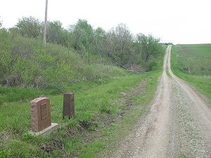
Sullivan erected survey marker
Survey marker
Survey markers, also called survey marks, and sometimes geodetic marks, are objects placed to mark key survey points on the Earth's surface. They are used in geodetic and land surveying. Informally, such marks are referred to as benchmarks, although strictly speaking the term "benchmark" is...
s along the line. The northwest corner of Missouri was established in a marker near Sheridan, Missouri
Sheridan, Missouri
Sheridan is a city in Worth County, Missouri, United States, near the Platte River. The population was 185 at the 2000 census, at which time it was a town.-Geography:Sheridan is located at ....
From there he continued east establishing the Sullivan Line
Sullivan Line
The Sullivan Line is the border between Missouri and Iowa.The line was initially created to establish the limits of Native American territory ; disputes over the boundary were to erupt into the Honey War; and the boundary was to be the basis for the Iowa portion of the Mormon Trail.In 1804, in the...
to the Des Moines River just south of Farmington, Iowa
Farmington, Iowa
Farmington is a city in Van Buren County, Iowa, United States. The population was 756 at the 2000 census.-Geography:Farmington is located at , on the east bank of Des Moines River....
where he made no note of rapids and called it a "small river with shallow gentle water." He did continue his survey another 20 miles (32.2 km) to the Mississippi.
Confusion over the terms of the Des Moines Rapids on the Mississippi and the phrase rapids on the Des Moines River was to contribute to the border skirmish.
Missouri boundaries
When Missouri applied for statehood first in 1818 various proposals for boundaries were put forth including a western boundary at the mouth of the Nodaway RiverNodaway River
The Nodaway River is a river in southwest Iowa and northwest Missouri.-Etymology:The river's name first appears in the journal of Lewis and Clark, who camped at the mouth of the river on July 8, 1804, but who provide no derivation of the name. There exist several proposed etymologies...
about 30 miles (48.3 km) west and the mouth of the Rock River (Illinois)
Rock River (Illinois)
The Rock River is a tributary of the Mississippi River, approximately long, in the U.S. states of Wisconsin and Illinois. It rises in southeast Wisconsin, in the Theresa Marsh near Theresa, Wisconsin in northeast Dodge County, Wisconsin approximately south of Fond du Lac, Wisconsin...
opposite Rock Island, Illinois
Rock Island, Illinois
Rock Island is the county seat of Rock Island County, Illinois, United States. The population was 40,884 at the 2010 census. Located on the Mississippi River, it is one of the Quad Cities, along with neighboring Moline, East Moline, and the Iowa cities of Davenport and Bettendorf. The Quad Cities...
. Missouri was already going to be the largest state in area when it entered the Union and there was concern about making it even bigger. Sullivan was a delegate to the convention that was to ultimate declare the boundaries to be the two lines he had drawn.
The constitution defined the boundary as:
- Beginning in the middle of the Mississippi River, on the parallel of thirty-six degrees of north latitude; thence west along the said parallel of latitude to the St. Francois River; thence up and following the course of that river, in the middle of the main channel thereof, to the parallel of latitude of thirty-six degrees and thirty minutes; thence west along the same to a point where the said parallel is intersected by a meridian line passing through the middle of the mouth of the Kansas River, where the same empties into the Missouri River; thence, from the point aforesaid, north along the said meridian line, to the intersection of the parallel of latitude which passes through the rapids of the River Des Moines, making said line correspond with the Indian boundary-line; thence east from the point of intersection last aforesaid, along the said parallel of latitude, to the middle of the channel of the main fork of the said River Des Moines; thence down along the middle of the main channel of the said River Des Moines to the mouth of the same, where it empties into the Mississippi River; thence due east to the middle of the main channel of the Mississippi River; thence down and following the course of the Mississippi River, in the middle of the main channel thereof, to the place of beginning.
The wording of the boundary "extending westward of the rapids of the river Des Moines" was to cause confusion.
In the Treaty of Washington (1824) the Sac and Fox ceded their land in Missouri. The land below the Sullivan Line between the Des Moines and Mississippi was set aside as Half Breed Tract.
In the Indian Removal Act
Indian Removal Act
The Indian Removal Act was signed into law by President Andrew Jackson on May 28, 1830.The Removal Act was strongly supported in the South, where states were eager to gain access to lands inhabited by the Five Civilized Tribes. In particular, Georgia, the largest state at that time, was involved in...
of 1830, all tribes were to moved west and south of the line Sullivan had drawn.
In 1834 Half Breed Tract was opened to public settlement. This along the movement of Iowa into Wisconsin Territory
Wisconsin Territory
The Territory of Wisconsin was an organized incorporated territory of the United States that existed from July 3, 1836, until May 29, 1848, when an eastern portion of the territory was admitted to the Union as the State of Wisconsin...
was to spur Missouri to reconsider its northern border, first by extending its border west to the Missouri River in the Platte Purchase
Platte Purchase
The Platte Purchase was a land acquisition in 1836 by the United States government from Native American tribes all of which was east bank lands along the Missouri River that added to the northwest corner of the state of Missouri. The area acquired is almost as large as the states of Delaware and...
in northwest Missouri and then started reconsidering the northeast corner.
The "War"
In 1837 the Missouri General AssemblyMissouri General Assembly
The Missouri General Assembly is the state legislature of the U.S. state of Missouri. The bicameral General Assembly is composed of a 34-member Senate, and a 163-member House of Representatives. Members of both houses of the General Assembly are subject to term limits...
ordered the line to be resurveyed. When Wisconsin Territory refused to participate in the survey, J.C. Brown began a survey in which he ignored the traditional definition of the rapids below Fort Madison on the Mississippi and instead looked for rapids on the Des Moines River itself and identified the rapids as being at Keosauqua, Iowa
Keosauqua, Iowa
Keosauqua is a city in Van Buren County, Iowa, United States. The population was 1,066 at the 2000 census. It is the county seat of Van Buren County.-History:...
about 9.5 miles (15.3 km) into modern Iowa.
As the dispute heated up, Missouri was to note there were rapids on the Des Moines all the way to Des Moines, Iowa
Des Moines, Iowa
Des Moines is the capital and the most populous city in the US state of Iowa. It is also the county seat of Polk County. A small portion of the city extends into Warren County. It was incorporated on September 22, 1851, as Fort Des Moines which was shortened to "Des Moines" in 1857...
. Meanwhile, Iowa was to maintain its ownership extended to a line about 15 miles (24.1 km) into modern Missouri at the mouth of the Des Moines.
Tax agents from Kahoka, Missouri
Kahoka, Missouri
Kahoka is a city in Clark County, Missouri, United States. The population was 2,241 at the 2000 census. It is the county seat of Clark County. The city was founded in 1857 and is named for the Cahokia tribe of the Illiniwek or Illinois Confederacy....
tried to collect taxes in what is now Van Buren County, Iowa and Davis County, Iowa
Davis County, Iowa
-2010 census:The 2010 census recorded a population of 8,753 in the county, with a population density of . There were 3,600 housing units, of which 3,201 were occupied.-2000 census:...
. The Iowa residents allegedly carrying pitchfork
Pitchfork
A pitchfork is an agricultural tool with a long handle and long, thin, widely separated pointed tines used to lift and pitch loose material, such as hay, leaves, grapes, dung or other agricultural materials. Pitchforks typically have two or three tines...
s chased away the tax collectors who chopped down three honey bee
Honey bee
Honey bees are a subset of bees in the genus Apis, primarily distinguished by the production and storage of honey and the construction of perennial, colonial nests out of wax. Honey bees are the only extant members of the tribe Apini, all in the genus Apis...
trees in what is now Lacey-Keosauqua State Park to collect the honey for partial payment.
Missouri governor Lilburn Boggs
Lilburn Boggs
Lilburn Williams Boggs was the sixth Governor of Missouri from 1836 to 1840. He is now most widely remembered for his interactions with Joseph Smith and Porter Rockwell, and Missouri Executive Order 44, known by Mormons as the "Extermination Order", issued in response to the ongoing conflict...
sent the state militia to the Iowa border and an Iowa mob captured the sheriff of Clark County, Missouri
Clark County, Missouri
Clark County is a county located in the U.S. state of Missouri. As of 2010, the population was 7,139. Its county seat is Kahoka. The county was organized in 1836 and named after William Clark, leader of the Lewis and Clark Expedition and later a Governor of Missouri Territory.Clark County is part...
and incarcerated him in the Muscatine, Iowa
Muscatine, Iowa
Muscatine is a city in Muscatine County, Iowa, United States. The population was 22,886 in the 2010 census, an increase from 22,697 in the 2000 census. It is the county seat of Muscatine County...
jail. The Iowa militia was also called out by Iowa Territory governor Robert Lucas
Robert Lucas (governor)
Robert Lucas was the 12th Governor of the U.S. state of Ohio, serving from 1832 to 1836. He served as the first Governor of Iowa Territory from 1838 to 1841.-Early life:...
.
According to one description about the Iowans:
- in the ranks were to be found men armed with blunderbussBlunderbussThe blunderbuss is a muzzle-loading firearm with a short, large caliber barrel, which is flared at the muzzle and frequently throughout the entire bore, and used with shot and other projectiles of relevant quantity and/or caliber. The blunderbuss could be considered to be an early form of shotgun,...
es, flintlocks, and quaint old ancestral swords that had probably adorned the walls for many generations. One private carried a ploughPloughThe plough or plow is a tool used in farming for initial cultivation of soil in preparation for sowing seed or planting. It has been a basic instrument for most of recorded history, and represents one of the major advances in agriculture...
coulter over his shoulder by means of a log chain, another had an old-fashioned sausage stuffer for a weapon, while a third shouldered a sheet iron sword about six feet long.
The two governors agreed to allow Congress resolve the issue. An arbitrary line was drawn between the two positions. However when Iowa entered the Union Congress was to rule the border was in fact at the Mississippi confluence, a position that was upheld by the U.S. Supreme Court in State of Missouri v. State of Iowa
State of Missouri v. State of Iowa (1849)
State of Missouri v. State of Iowa, 48 U.S. 660 , is a 9-to-0 ruling by the Supreme Court of the United States which held that Sullivan Line of 1816 was accepted boundary between the states of Iowa and Missouri...
, 48 U.S. 660 (1849).
Further reading
- Supreme Court decision
- Everett, Derek R. (2008, Fall). To Shed Our Blood for Our Beloved Territory: The Iowa-Missouri Borderland. The Annals of Iowa, 67(4), 269–297.