

Nodaway River
Encyclopedia
Etymology
The river's name (as "Nodawa") first appears in the journal of Lewis and Clark, who camped at the mouth of the river on July 8, 1804, but who provide no derivation of the name. There exist several proposed etymologies. The most probable is that it comes from an AlgonquianAlgonquian languages
The Algonquian languages also Algonkian) are a subfamily of Native American languages which includes most of the languages in the Algic language family. The name of the Algonquian language family is distinguished from the orthographically similar Algonquin dialect of the Ojibwe language, which is a...
term for the Sioux
Sioux
The Sioux are Native American and First Nations people in North America. The term can refer to any ethnic group within the Great Sioux Nation or any of the nation's many language dialects...
(such as Ojibwe
Ojibwe language
Ojibwe , also called Anishinaabemowin, is an indigenous language of the Algonquian language family. Ojibwe is characterized by a series of dialects that have local names and frequently local writing systems...
naadowe), derived from a Proto-Algonquian
Proto-Algonquian language
Proto-Algonquian is the name given to the proto-language from which the various languages of the Algonquian family are descended. It is generally estimated to have been spoken around 2,500 to 3,000 years ago, but on the question of where it was spoken there is less agreement...
name *naːtoweːwa, "speaker of a foreign language" (though sometimes claimed to mean "snake"). The name could also be from a Dakota Sioux
Lakota language
Lakota is a Siouan language spoken by the Lakota people of the Sioux tribes. While generally taught and considered by speakers as a separate language, Lakota is mutually understandable with the other two languages , and is considered by most linguists one of the three major varieties of the Sioux...
word meaning "crossed without a canoe".
History
Lewis and Clark camped at the river's mouth on Nodaway Island on July 8, 1804, by Nodaway, MissouriNodaway, Missouri
Nodaway, Missouri is a former town in Andrew County, Missouri near the confluence of the Nodaway River and Missouri RiverThe Lewis and Clark Expedition camped by the town on Nodaway Island on July 8, 1804 and took note of the river, on their trip to explore what would become the Oregon Country.The...
on the border of Holt County, Missouri
Holt County, Missouri
Holt County is a county located in the U.S. state of Missouri. The county is in the northwest part of the state. As of 2010, the population was 4,912. Its county seat is Oregon. The county was organized in 1841 and is named after the Missouri state legislator Dr...
and Andrew County, Missouri
Andrew County, Missouri
-External links:* from University of Missouri Division of Special Collections, Archives, and Rare Books...
and took note of the river.
Lewis and Clark liked the spot enough that they recommended it for the winter headquarters of Astor Expedition
Astor Expedition
The Astor Expedition of 1810-1812 was the next overland expedition from St. Louis, Missouri to the mouth of the Columbia River after the Corps of Discovery, led by Lewis and Clark.-History:...
of 1810-1812 that discovered the South Pass
South Pass
South Pass is two mountain passes on the Continental Divide in the Rocky Mountains in southwestern Wyoming. The passes are located in a broad low region, 35 miles broad, between the Wind River Range to the north and the Oregon Buttes and Great Divide Basin to the south, in southwestern Fremont...
in Wyoming through which hundreds of settlers on the Oregon Trail
Oregon Trail
The Oregon Trail is a historic east-west wagon route that connected the Missouri River to valleys in Oregon and locations in between.After 1840 steam-powered riverboats and steamboats traversing up and down the Ohio, Mississippi and Missouri rivers sped settlement and development in the flat...
, California Trail
California Trail
The California Trail was an emigrant trail of about across the western half of the North American continent from Missouri River towns to what is now the state of California...
, Mormon Trail
Mormon Trail
The Mormon Trail or Mormon Pioneer Trail is the 1,300 mile route that members of The Church of Jesus Christ of Latter-day Saints traveled from 1846 to 1868...
were to pass.
The river is navigable only by shallow fishing and row boats although steam ships navigated just inside its mouth. The river was the primary route for white settlers including Amos Graham and Isaac Hogan following the Platte Purchase
Platte Purchase
The Platte Purchase was a land acquisition in 1836 by the United States government from Native American tribes all of which was east bank lands along the Missouri River that added to the northwest corner of the state of Missouri. The area acquired is almost as large as the states of Delaware and...
of 1836 which opened northwest Missouri for settlement. Nodaway County, which derives its name from the river, was by far the biggest county in the purchase and the fourth largest in the state of Missouri.
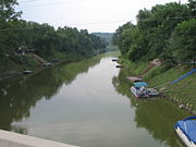
Description
Major tributaries in the Nodaway River basin are Seven Mile Creek, West Nodaway River, East Nodaway River, Middle Nodaway River, Clear Creek, Mill Creek, Elkhorn Creek, and Arapahoe Creek. The biggest town on the river is Clarinda, IowaClarinda, Iowa
-2010 census:The 2010 census recorded a population of 5,572 in the city, with a population density of . There were 2,180 housing units, of which 1,928 were occupied....
.
The Nodaway begins near Shambaugh, Iowa
Shambaugh, Iowa
Shambaugh is a city in Page County, Iowa, United States. The population was 188 at the 2000 census.-Geography:Shambaugh is located at along the West Nodaway River...
at the confluence of the East and West Nodaway rivers. The West Nodaway River rises northeast of Massena
Massena, Iowa
Massena is a city in Cass County, Iowa, United States. The population was 414 at the 2000 census. Massena's motto is: "The Home of Friendly People". Massena's sister community is Cumberland, Iowa...
in eastern Cass County, Iowa
Cass County, Iowa
-2010 census:The 2010 census recorded a population of 13,956 in the county, with a population density of . There were 6,591 housing units, of which 5,980 were occupied.-2000 census:...
, and flows 73.8 miles (118.8 km) south-southwest past Villisca
Villisca, Iowa
Villisca is a city in Montgomery County, Iowa, United States. The population was 1,344 at the 2000 census.-Geography:Villisca is located at .According to the United States Census Bureau, the city has a total area of , all land....
and Clarinda
Clarinda, Iowa
-2010 census:The 2010 census recorded a population of 5,572 in the city, with a population density of . There were 2,180 housing units, of which 1,928 were occupied....
to its junction with the East Nodaway. The East Nodaway River rises just west of Orient
Orient, Iowa
Orient is a city in Orient Township, Adair County, Iowa, United States. The population was 402 at the 2000 census.-Geography:Orient is located at ....
in Adair County and flows 72.8 miles (117.2 km) southwest past Prescott
Prescott, Iowa
Prescott is a city in Prescott Township, Adams County, Iowa, United States. The population was 266 at the 2000 census.-Geography:Prescott is located at ....
, Corning
Corning, Iowa
As of the census of 2000, there were 1,783 people, 803 households, and 452 families residing in the city. The population density was 1,132.3 people per square mile . There were 880 housing units at an average density of 558.9 per square mile...
, Brooks, and Nodaway
Nodaway, Iowa
Nodaway is a city in Nodaway Township, Adams County, Iowa, United States. The population was 132 at the 2000 census.-Geography:Nodaway is located at ....
to its confluence with the West Nodaway. The Middle Nodaway River rises in Adair County south of Casey
Casey, Iowa
Casey is a city in Adair and Guthrie Counties in the U.S. state of Iowa. The population was 478 at the 2000 census.The Guthrie County portion of Casey is part of the Des Moines–West Des Moines Metropolitan Statistical Area...
and flows 60.5 miles (97.4 km) southwest past Greenfield
Greenfield, Iowa
Greenfield is a city in Greenfield Township, Adair County, Iowa, United States. The population was 2,129 at the 2000 census. It is the county seat of Adair County. The current courthouse, which sits in the middle of the Greenfield Square, was built in 1891 and is listed on the National Register of...
, Fontanelle
Fontanelle, Iowa
Fontanelle is a city in Summerset Township, Adair County, Iowa, United States. The population was 692 at the 2000 census.-Geography:Fontanelle is located at ....
, and Carbon
Carbon, Iowa
Carbon is a city in Douglas Township, Adams County, Iowa, United States. The population was 28 at the 2000 census.- History :Carbon Iowa is located on the Nodaway River. This was home to the Pottawatomie, Oto and Iowa Indian tribes until the treaty of 1851 forced their removal to Kansas or Indian...
to join the West Nodaway just below Villisca, Iowa
Villisca, Iowa
Villisca is a city in Montgomery County, Iowa, United States. The population was 1,344 at the 2000 census.-Geography:Villisca is located at .According to the United States Census Bureau, the city has a total area of , all land....
, 20.2 miles (32.5 km) above the West Nodaway's juncture with the East Nodaway. The East and West Nodaway join to form the Nodaway River four miles (6 km) north of the Iowa-Missouri border, and the river enters Missouri near Clearmont, Missouri
Clearmont, Missouri
Clearmont is a city in Nodaway County, Missouri, United States. The population was 191 at the 2000 census.-Geography:Clearmont is located at .According to the United States Census Bureau, the city has a total area of , all land....
.
Elevations in the Nodaway system range from just under 1400 feet (426.7 m) above sea level at the source of the Middle Nodaway, to 950 feet (289.6 m) at the beginning of the main stem, to 800 feet (243.8 m) at its mouth on the Missouri River in Nodaway, Missouri
Nodaway, Missouri
Nodaway, Missouri is a former town in Andrew County, Missouri near the confluence of the Nodaway River and Missouri RiverThe Lewis and Clark Expedition camped by the town on Nodaway Island on July 8, 1804 and took note of the river, on their trip to explore what would become the Oregon Country.The...
in Andrew County, Missouri
Andrew County, Missouri
-External links:* from University of Missouri Division of Special Collections, Archives, and Rare Books...
.
The Nodaway River is a sixth order
Strahler Stream Order
In mathematics, the Strahler number or Horton–Strahler number of a mathematical tree is a numerical measure of its branching complexity....
river with a basin area of 1820 square miles (4,713.8 km²).
The Platte River
Platte River (Missouri)
The Platte River is a tributary of the Missouri River, about long, in southwestern Iowa and northwestern Missouri in the United States. It is sometimes known as the Little Platte River to distinguish it from the larger Platte River, also a tributary of the Missouri, in nearby Nebraska; the Platte...
basin is to the east and the Grand River
Grand River (Missouri)
The Grand River is a river that stretches from northernmost tributary origins between Creston and Winterset in Iowa approximately to its mouth on the Missouri River near Brunswick, Missouri....
and Des Moines River
Des Moines River
The Des Moines River is a tributary river of the Mississippi River, approximately long to its farther headwaters, in the upper Midwestern United States...
basins to the northeast, with the latter defining the boundary between the Missouri River and Mississippi River basins. The west side is bound by the Tarkio River
Tarkio River
The Tarkio River is a non-navigable river that stretches for approximately from Cass County, Iowa to its mouth on the Missouri River in Holt County, Missouri....
basin and in the northwest by the Nishnabotna River
Nishnabotna River
The Nishnabotna River is a tributary of the Missouri River in southwestern Iowa, northwestern Missouri and southeastern Nebraska in the United States. It flows for most of its length as two parallel streams in Iowa, the East Nishnabotna River and the West Nishnabotna River...
basin.
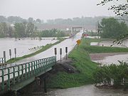
The Nodaway River basin is prone to extensive flooding and can contribute as much as 20% of the flood crest of the Missouri River near its mouth.
At Graham, Missouri
Graham, Missouri
Graham is a city in Nodaway County, Missouri, United States. The population was 191 at the 2000 census, at which time it was a town.-Geography:Graham is located at ....
its normal flow is 1,011 cubic feet per second (28.6 m³/s). But during the Great Flood of 1993
Great Flood of 1993
The Great Mississippi and Missouri Rivers Flood of 1993 occurred in the American Midwest, along the Mississippi and Missouri rivers and their tributaries, from April to October 1993. The flood was among the most costly and devastating to ever occur in the United States, with $15 billion in damages...
the river was flowing 78,300 ft³/s (2220 m³/s) at Graham.