

High Road to Taos, New Mexico
Encyclopedia
Sangre de Cristo Mountains
The Sangre de Cristo Mountains are the southernmost subrange of the Rocky Mountains. They are located in southern Colorado and northern New Mexico in the United States...
between Santa Fe
Santa Fe, New Mexico
Santa Fe is the capital of the U.S. state of New Mexico. It is the fourth-largest city in the state and is the seat of . Santa Fe had a population of 67,947 in the 2010 census...
and Taos
Taos, New Mexico
Taos is a town in Taos County in the north-central region of New Mexico, incorporated in 1934. As of the 2000 census, its population was 4,700. Other nearby communities include Ranchos de Taos, Cañon, Taos Canyon, Ranchitos, and El Prado. The town is close to Taos Pueblo, the Native American...
. (The "Low Road" runs through the valleys along the Rio Grande). It winds through high desert, mountains, forests, small farms, and tiny Spanish
Spain
Spain , officially the Kingdom of Spain languages]] under the European Charter for Regional or Minority Languages. In each of these, Spain's official name is as follows:;;;;;;), is a country and member state of the European Union located in southwestern Europe on the Iberian Peninsula...
Land Grant
Land grant
A land grant is a gift of real estate – land or its privileges – made by a government or other authority as a reward for services to an individual, especially in return for military service...
villages and Pueblo Indian
Native Americans in the United States
Native Americans in the United States are the indigenous peoples in North America within the boundaries of the present-day continental United States, parts of Alaska, and the island state of Hawaii. They are composed of numerous, distinct tribes, states, and ethnic groups, many of which survive as...
villages. Scattered along the way are the galleries and studios of traditional artisans and artists drawn by the natural beauty. It has been recognized by the state of New Mexico
New Mexico
New Mexico is a state located in the southwest and western regions of the United States. New Mexico is also usually considered one of the Mountain States. With a population density of 16 per square mile, New Mexico is the sixth-most sparsely inhabited U.S...
as an official Scenic Byway
Scenic route
A scenic route, tourist road, tourist route, theme route, or scenic byway is a specially designated road or waterway that travels through an area of natural or cultural beauty...
.
Nambé
The High Road to Taos Scenic Byway begins north of Santa FeSanta Fe, New Mexico
Santa Fe is the capital of the U.S. state of New Mexico. It is the fourth-largest city in the state and is the seat of . Santa Fe had a population of 67,947 in the 2010 census...
in Pojoaque, New Mexico
Pojoaque, New Mexico
Pojoaque is a census-designated place in Santa Fe County, New Mexico, United States. It is part of the Santa Fe, New Mexico Metropolitan Statistical Area. The population was 1,261 at the 2000 census. Pojoaque and Pojoaque Pueblo are neighboring communities...
, at the intersection of U.S. 285/84 and State Road 503. It continues along State Road 503 to Nambé Pueblo. Founded in the 14th century, Nambé
Nambé Pueblo
Nambé Oweenge Pueblo is a pueblo in Santa Fe County, New Mexico, United States. Located about 15 miles north of Santa Fe at the base of the Sangre de Cristo Mountains. The Pueblo of Nambé has existed since the 14th century and was a primary cultural, economic, and religious center at the time of...
means "People of the Round Earth" in Tewa
Tewa language
Tewa is a Kiowa–Tanoan language spoken by Pueblo people, mostly in the Rio Grande valley in New Mexico north of Santa Fe. The 1980 census counted 1,298 speakers, almost all of whom are bilingual in English...
, their native language. The pueblo plaza is a registered National Historic Landmark
National Historic Landmark
A National Historic Landmark is a building, site, structure, object, or district, that is officially recognized by the United States government for its historical significance...
. The church on State Road 503 is not original; ill-considered efforts to restore the grand original church caused it to collapse. The pueblo encompasses 19000 acres (76.9 km²) of land with waterfalls, lakes, and mountainous areas. Until about 1830, Nambe was known for a pottery style called Nambe Polychrome. Today, pottery is making a comeback, especially black-on-black and red-on-white. Weaving is also reemerging.
Chimayó
The road continues through the rolling hills and wind-carved hoodoos of the badlandsBadlands
A badlands is a type of dry terrain where softer sedimentary rocks and clay-rich soils have been extensively eroded by wind and water. It can resemble malpaís, a terrain of volcanic rock. Canyons, ravines, gullies, hoodoos and other such geological forms are common in badlands. They are often...
. At 7.5 miles (12.1 km), the High Road turns left onto State Road 98 (Juan Medina Road), which continues across the open, rolling high desert until it dips down to the green, farming valley of Chimayó
Chimayo, New Mexico
Chimayo is a census-designated place in Rio Arriba and Santa Fe Counties in the U.S. state of New Mexico; the community's name is more correctly pronounced and spelled Chimayó, a name that derives from a Tewa name for a local landmark, the hill of Tsi Mayoh...
. Visitors often stop at the historic Santuario de Chimayó. Built between 1811 and 1816, this tiny church is visited by pilgrims from all over the United States
United States
The United States of America is a federal constitutional republic comprising fifty states and a federal district...
and old Mexico
Mexico
The United Mexican States , commonly known as Mexico , is a federal constitutional republic in North America. It is bordered on the north by the United States; on the south and west by the Pacific Ocean; on the southeast by Guatemala, Belize, and the Caribbean Sea; and on the east by the Gulf of...
, especially on Good Friday
Good Friday
Good Friday , is a religious holiday observed primarily by Christians commemorating the crucifixion of Jesus Christ and his death at Calvary. The holiday is observed during Holy Week as part of the Paschal Triduum on the Friday preceding Easter Sunday, and may coincide with the Jewish observance of...
of Easter
Easter
Easter is the central feast in the Christian liturgical year. According to the Canonical gospels, Jesus rose from the dead on the third day after his crucifixion. His resurrection is celebrated on Easter Day or Easter Sunday...
week, when crowds swell to the thousands. A little further on is the Rancho de Chimayó Restaurant, housed in a historic adobe
Adobe
Adobe is a natural building material made from sand, clay, water, and some kind of fibrous or organic material , which the builders shape into bricks using frames and dry in the sun. Adobe buildings are similar to cob and mudbrick buildings. Adobe structures are extremely durable, and account for...
building. Chimayó
Chimayo, New Mexico
Chimayo is a census-designated place in Rio Arriba and Santa Fe Counties in the U.S. state of New Mexico; the community's name is more correctly pronounced and spelled Chimayó, a name that derives from a Tewa name for a local landmark, the hill of Tsi Mayoh...
also has many traditional weaving studios owned by descendants of the original Spanish
Spanish people
The Spanish are citizens of the Kingdom of Spain. Within Spain, there are also a number of vigorous nationalisms and regionalisms, reflecting the country's complex history....
settlers.
Córdova
Where State Road 98 dead-ends, the road turns right onto State Road 76 and begins the climb into the Sangre de Cristo MountainsSangre de Cristo Mountains
The Sangre de Cristo Mountains are the southernmost subrange of the Rocky Mountains. They are located in southern Colorado and northern New Mexico in the United States...
and the little villages of the High Road. First is Córdova, a collection of narrow streets above a river valley, accessible via a road on the right. Córdova is known for its traditional woodcarvers, such as George López
George López
George López was a renowned Santos Woodcarver who was awarded the National Heritage Fellowship by the National Endowment for the Arts in 1982. He was born in the small village of Cordova, New Mexico which is situated in a small valley of the Sangre de Cristo Mountains...
, who carve santos
Santo (art)
Santo is a traditional New Mexican genre of religious sculpture. The word "santo" is also used to refer to individual works in this genre...
(saints) in the "Córdova Style": unpainted but elaborately carved and featuring the distinctive grain and shape of the wood. A very short drive takes you into the village and back to State Road 76.
Truchas
The road continues to climb to the top of a high mesa and the village of TruchasTruchas, New Mexico
Truchas is an unincorporated community in Rio Arriba County, New Mexico, United States. Located on the scenic High Road to Taos, it is halfway between Santa Fe in the south, and Taos to the north.Truchas has the ZIP code 87578...
, a scattering of adobe
Adobe
Adobe is a natural building material made from sand, clay, water, and some kind of fibrous or organic material , which the builders shape into bricks using frames and dry in the sun. Adobe buildings are similar to cob and mudbrick buildings. Adobe structures are extremely durable, and account for...
houses backed by the snow-capped Truchas Peaks. (The High Road and State Road 76 turn left, but much of the village is straight ahead on State Road 75.) This Hispanic
Hispanic
Hispanic is a term that originally denoted a relationship to Hispania, which is to say the Iberian Peninsula: Andorra, Gibraltar, Portugal and Spain. During the Modern Era, Hispanic sometimes takes on a more limited meaning, particularly in the United States, where the term means a person of ...
farming community once furnished the set for the movie version of the John Nichols
John Nichols
John Nichols may refer to:* John Nichols , author of The Milagro Beanfield War* John Nichols , British diplomat and Ambassador to Switzerland* John Nichols , English cricketer...
novel The Milagro Beanfield War
The Milagro Beanfield War
The Milagro Beanfield War is a 1988 American drama film based on the John Nichols novel of the same name, the first book in a trilogy. It was directed by Robert Redford and the screenplay was written by Nichols and David S. Ward...
. Truchas
Truchas, New Mexico
Truchas is an unincorporated community in Rio Arriba County, New Mexico, United States. Located on the scenic High Road to Taos, it is halfway between Santa Fe in the south, and Taos to the north.Truchas has the ZIP code 87578...
was established by a royal land grant
Land grant
A land grant is a gift of real estate – land or its privileges – made by a government or other authority as a reward for services to an individual, especially in return for military service...
in 1754 to create a buffer against nomad
Nomad
Nomadic people , commonly known as itinerants in modern-day contexts, are communities of people who move from one place to another, rather than settling permanently in one location. There are an estimated 30-40 million nomads in the world. Many cultures have traditionally been nomadic, but...
ic Apache
Apache
Apache is the collective term for several culturally related groups of Native Americans in the United States originally from the Southwest United States. These indigenous peoples of North America speak a Southern Athabaskan language, which is related linguistically to the languages of Athabaskan...
and Comanche
Comanche
The Comanche are a Native American ethnic group whose historic range consisted of present-day eastern New Mexico, southern Colorado, northeastern Arizona, southern Kansas, all of Oklahoma, and most of northwest Texas. Historically, the Comanches were hunter-gatherers, with a typical Plains Indian...
bands who often raided both Spanish
Spain
Spain , officially the Kingdom of Spain languages]] under the European Charter for Regional or Minority Languages. In each of these, Spain's official name is as follows:;;;;;;), is a country and member state of the European Union located in southwestern Europe on the Iberian Peninsula...
villages and Native American
Native Americans in the United States
Native Americans in the United States are the indigenous peoples in North America within the boundaries of the present-day continental United States, parts of Alaska, and the island state of Hawaii. They are composed of numerous, distinct tribes, states, and ethnic groups, many of which survive as...
pueblo
Pueblo
Pueblo is a term used to describe modern communities of Native Americans in the Southwestern United States of America. The first Spanish explorers of the Southwest used this term to describe the communities housed in apartment-like structures built of stone, adobe mud, and other local material...
s. Hence, it was built as a walled compound around a plaza
Plaza
Plaza is a Spanish word related to "field" which describes an open urban public space, such as a city square. All through Spanish America, the plaza mayor of each center of administration held three closely related institutions: the cathedral, the cabildo or administrative center, which might be...
. Its settlers hand-dug miles of acequias
Acequia
An acequia or séquia is a community-operated waterway used in Spain and former Spanish colonies in the Americas for irrigation. Particularly in Spain, the Andes, northern Mexico, and the modern-day American Southwest, acequias are usually historically engineered canals that carry snow runoff or...
(irrigation
Irrigation
Irrigation may be defined as the science of artificial application of water to the land or soil. It is used to assist in the growing of agricultural crops, maintenance of landscapes, and revegetation of disturbed soils in dry areas and during periods of inadequate rainfall...
ditches) to bring water from the trout-filled river that gave the town its name. Although today's residents still work their farms, many also commute to jobs in Santa Fe
Santa Fe, New Mexico
Santa Fe is the capital of the U.S. state of New Mexico. It is the fourth-largest city in the state and is the seat of . Santa Fe had a population of 67,947 in the 2010 census...
or Los Alamos
Los Alamos, New Mexico
Los Alamos is a townsite and census-designated place in Los Alamos County, New Mexico, United States, built upon four mesas of the Pajarito Plateau and the adjoining White Rock Canyon. The population of the CDP was 12,019 at the 2010 Census. The townsite or "the hill" is one part of town while...
. A few still make their living as traditional craftspeople alongside the many European-American artists and galleries that have been drawn to Truchas's
Truchas, New Mexico
Truchas is an unincorporated community in Rio Arriba County, New Mexico, United States. Located on the scenic High Road to Taos, it is halfway between Santa Fe in the south, and Taos to the north.Truchas has the ZIP code 87578...
mountain views.
Ojo Sarco
The High Road continues along State Road 76 through the Carson National ForestCarson National Forest
Carson National Forest is a national forest in northern New Mexico, United States. It encompasses 6,070 square kilometers and is administered by the United States Forest Service...
to a series of very small villages. First is Ojo Sarco, believed to be named for a spring in a nearby cañada
Cañada
The Spanish word cañada means glen; it is etymologically unrelated to Canada, which is derived from an Iroquois word meaning "village" or "settlement" and generally refers to the country in North America...
(glen). The name was sometimes spelled Ojo Zarco; ojo is now translated as "eye" in Spanish, but also used to mean "spring" and zarco means "blue", hence "blue spring".
Las Trampas
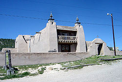
Las Trampas, New Mexico
Las Trampas or Trampas is a small unincorporated town in Taos County, New Mexico, United States. Located on the scenic High Road to Taos , it is approximately halfway between Santa Fe to the south and Taos to the north.Founded in 1751 by twelve Spanish families from Santa Fe, it is known for the...
, founded in 1751 by a royal land grant, entitled Santo Tomás Apostol del Río de las Trampas ("Saint Thomas, Apostle
Thomas the Apostle
Thomas the Apostle, also called Doubting Thomas or Didymus was one of the Twelve Apostles of Jesus. He is best known for questioning Jesus' resurrection when first told of it, then proclaiming "My Lord and my God" on seeing Jesus in . He was perhaps the only Apostle who went outside the Roman...
of the River of Traps"). Despite the heavy toll taken by a smallpox
Smallpox
Smallpox was an infectious disease unique to humans, caused by either of two virus variants, Variola major and Variola minor. The disease is also known by the Latin names Variola or Variola vera, which is a derivative of the Latin varius, meaning "spotted", or varus, meaning "pimple"...
epidemic and raids by Plains Indians
Plains Indians
The Plains Indians are the Indigenous peoples who live on the plains and rolling hills of the Great Plains of North America. Their colorful equestrian culture and resistance to White domination have made the Plains Indians an archetype in literature and art for American Indians everywhere.Plains...
, the village of Las Trampas
Las Trampas, New Mexico
Las Trampas or Trampas is a small unincorporated town in Taos County, New Mexico, United States. Located on the scenic High Road to Taos , it is approximately halfway between Santa Fe to the south and Taos to the north.Founded in 1751 by twelve Spanish families from Santa Fe, it is known for the...
survived and the settlers managed to build the stately San José de Gracia Church
San José de Gracia Church
The San Jose de Gracia Church, also known as Church of Santo Tomas Del Rio de Las Trampas, is a church built between 1760 and 1776 in Las Trampas, New Mexico. Originally named Santo Tomas del Rio de las Trampas, the church is of adobe construction with a mud-plaster exterior, which is renewed...
, completed in 1776. It is considered a model of the Spanish colonial church architecture found throughout New Mexico. It has reredos
Reredos
thumb|300px|right|An altar and reredos from [[St. Josaphat's Roman Catholic Church|St. Josaphat Catholic Church]] in [[Detroit]], [[Michigan]]. This would be called a [[retable]] in many other languages and countries....
(altar screens) painted by well-known santeros
Santero
A santero may refer to either:*a practictioner of Santería*an artisan who creates santos and other Spanish-style religious art...
(artisans who create santos. The church is a National Historic Landmark
National Historic Landmark
A National Historic Landmark is a building, site, structure, object, or district, that is officially recognized by the United States government for its historical significance...
, and the village is a is a National Historic District
Historic district
A historic district or heritage district is a section of a city which contains older buildings considered valuable for historical or architectural reasons. In some countries, historic districts receive legal protection from development....
. The building across from the church with the little bell tower was the school.
El Valle and Ojito
State Road 76 continues through the Carson National ForestCarson National Forest
Carson National Forest is a national forest in northern New Mexico, United States. It encompasses 6,070 square kilometers and is administered by the United States Forest Service...
. Smaller roads lead off to El Valle and Ojito, both settled by colonists from Las Trampas
Las Trampas, New Mexico
Las Trampas or Trampas is a small unincorporated town in Taos County, New Mexico, United States. Located on the scenic High Road to Taos , it is approximately halfway between Santa Fe to the south and Taos to the north.Founded in 1751 by twelve Spanish families from Santa Fe, it is known for the...
. Both are accessed by scenic drives through the forest.
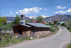
Chamisal
The next village on SR 76 is ChamisalChamisal, New Mexico
Chamisal is a census-designated place in Taos County, New Mexico, United States. It is on the scenic High Road to Taos. The population was 301 at the 2000 census.-Geography:Chamisal is located at ....
. It, too, was settled by Spanish
Spanish people
The Spanish are citizens of the Kingdom of Spain. Within Spain, there are also a number of vigorous nationalisms and regionalisms, reflecting the country's complex history....
villagers moving out from Las Trampas
Las Trampas, New Mexico
Las Trampas or Trampas is a small unincorporated town in Taos County, New Mexico, United States. Located on the scenic High Road to Taos , it is approximately halfway between Santa Fe to the south and Taos to the north.Founded in 1751 by twelve Spanish families from Santa Fe, it is known for the...
; all of these villages lie within the Las Trampas
Las Trampas, New Mexico
Las Trampas or Trampas is a small unincorporated town in Taos County, New Mexico, United States. Located on the scenic High Road to Taos , it is approximately halfway between Santa Fe to the south and Taos to the north.Founded in 1751 by twelve Spanish families from Santa Fe, it is known for the...
land grant
Land grant
A land grant is a gift of real estate – land or its privileges – made by a government or other authority as a reward for services to an individual, especially in return for military service...
. Chamisal
Chamisal, New Mexico
Chamisal is a census-designated place in Taos County, New Mexico, United States. It is on the scenic High Road to Taos. The population was 301 at the 2000 census.-Geography:Chamisal is located at ....
is probably named for the "chamisa" shrub (Chrysothamnus
Chrysothamnus
Chrysothamnus is a member of the plant family Asteraceae. It is a semi-deciduous shrub, sometimes also called sagebrush. The native distribution is in the arid western United States and northern Mexico...
, or rabbitbrush) which turns golden in late summer. Chamisal Creek flows northwest to join the Peñasco River. There is a small, old church in the village (follow the sign to the old plaza).
Picurís
When SR 76 ends at a stop sign, the High Road turns right onto State Road 75. However, turn left to visit Picurís PuebloPicuris Pueblo, New Mexico
Picuris Pueblo is a census-designated place in Taos County, New Mexico, United States. The population was 86 at the 2000 census. The Pueblo people are from the Tiwa ethnic group of Native Americans. Picurís Pueblo is a member of the Eight Northern Pueblos.Picuris village has occupied its present...
. Spanish
Spain
Spain , officially the Kingdom of Spain languages]] under the European Charter for Regional or Minority Languages. In each of these, Spain's official name is as follows:;;;;;;), is a country and member state of the European Union located in southwestern Europe on the Iberian Peninsula...
explorer Don Juan de Oñate
Juan de Oñate
Don Juan de Oñate y Salazar was a Spanish explorer, colonial governor of the New Spain province of New Mexico, and founder of various settlements in the present day Southwest of the United States.-Biography:...
called these people "pikuria"--those who paint. Before the Spanish
Spanish people
The Spanish are citizens of the Kingdom of Spain. Within Spain, there are also a number of vigorous nationalisms and regionalisms, reflecting the country's complex history....
came, Picurís
Picuris Pueblo, New Mexico
Picuris Pueblo is a census-designated place in Taos County, New Mexico, United States. The population was 86 at the 2000 census. The Pueblo people are from the Tiwa ethnic group of Native Americans. Picurís Pueblo is a member of the Eight Northern Pueblos.Picuris village has occupied its present...
was one of the largest and most powerful of the pueblos, located at the confluence of two rivers and on a major pass that leads through the mountains to the Great Plains
Great Plains
The Great Plains are a broad expanse of flat land, much of it covered in prairie, steppe and grassland, which lies west of the Mississippi River and east of the Rocky Mountains in the United States and Canada. This area covers parts of the U.S...
in the east. This strategic location made it a key site for trade with the Apache
Apache
Apache is the collective term for several culturally related groups of Native Americans in the United States originally from the Southwest United States. These indigenous peoples of North America speak a Southern Athabaskan language, which is related linguistically to the languages of Athabaskan...
s, but once the Comanche
Comanche
The Comanche are a Native American ethnic group whose historic range consisted of present-day eastern New Mexico, southern Colorado, northeastern Arizona, southern Kansas, all of Oklahoma, and most of northwest Texas. Historically, the Comanches were hunter-gatherers, with a typical Plains Indian...
s arrived and the Spanish
Spanish people
The Spanish are citizens of the Kingdom of Spain. Within Spain, there are also a number of vigorous nationalisms and regionalisms, reflecting the country's complex history....
brought horses, the pueblo became vulnerable to attack. The fierce Picurís continued to fight the Spanish
Spanish people
The Spanish are citizens of the Kingdom of Spain. Within Spain, there are also a number of vigorous nationalisms and regionalisms, reflecting the country's complex history....
even after the Reconquest, and lost many members of the tribe as a result. Like Taos Pueblo
Taos Pueblo
Taos Pueblo is an ancient pueblo belonging to a Taos speaking Native American tribe of Pueblo people. It is approximately 1000 years old and lies about north of the modern city of Taos, New Mexico, USA...
, Picurís
Picuris Pueblo, New Mexico
Picuris Pueblo is a census-designated place in Taos County, New Mexico, United States. The population was 86 at the 2000 census. The Pueblo people are from the Tiwa ethnic group of Native Americans. Picurís Pueblo is a member of the Eight Northern Pueblos.Picuris village has occupied its present...
is a Tiwa
Tiwa people
The Tiwa are group of related Tanoan pueblo peoples in New Mexico and Texas. They traditionally spoke a Tiwa language , and are divided into the two Northern Tiwa groups, in Taos and Picuris, and the Southern Tiwa in Isleta and Sandia, around what is now Albuquerque, and near El Paso.-Name:Tiwa is...
pueblo. Picurís
Picuris Pueblo, New Mexico
Picuris Pueblo is a census-designated place in Taos County, New Mexico, United States. The population was 86 at the 2000 census. The Pueblo people are from the Tiwa ethnic group of Native Americans. Picurís Pueblo is a member of the Eight Northern Pueblos.Picuris village has occupied its present...
today, while small, has a thriving buffalo herd and runs a hotel in Santa Fe
Santa Fe, New Mexico
Santa Fe is the capital of the U.S. state of New Mexico. It is the fourth-largest city in the state and is the seat of . Santa Fe had a population of 67,947 in the 2010 census...
. It is known for its gold-hued mica
Mica
The mica group of sheet silicate minerals includes several closely related materials having highly perfect basal cleavage. All are monoclinic, with a tendency towards pseudohexagonal crystals, and are similar in chemical composition...
ceous pottery (featuring flecks of shiny mica
Mica
The mica group of sheet silicate minerals includes several closely related materials having highly perfect basal cleavage. All are monoclinic, with a tendency towards pseudohexagonal crystals, and are similar in chemical composition...
). When the 200-year-old San Lorenzo de Picurís
Picuris Pueblo, New Mexico
Picuris Pueblo is a census-designated place in Taos County, New Mexico, United States. The population was 86 at the 2000 census. The Pueblo people are from the Tiwa ethnic group of Native Americans. Picurís Pueblo is a member of the Eight Northern Pueblos.Picuris village has occupied its present...
church collapsed in 1989 due to water damage, pueblo
Pueblo
Pueblo is a term used to describe modern communities of Native Americans in the Southwestern United States of America. The first Spanish explorers of the Southwest used this term to describe the communities housed in apartment-like structures built of stone, adobe mud, and other local material...
members rebuilt it by hand. San Lorenzo Feast Day is August 10. (Tribal members request that visitors get permission before taking photos anywhere on the pueblo
Pueblo
Pueblo is a term used to describe modern communities of Native Americans in the Southwestern United States of America. The first Spanish explorers of the Southwest used this term to describe the communities housed in apartment-like structures built of stone, adobe mud, and other local material...
.)
Peñasco
The High Road continues on State Road 75 into PeñascoPenasco, New Mexico
Penasco is a census-designated place in Taos County, New Mexico, United States. It is on the scenic High Road to Taos. The population is estimated at about 2,320+ .-Geography:Penasco is located at ....
. The villages of Llano San Juan, Llano Largo, and Santa Barbara in the Peñasco
Penasco, New Mexico
Penasco is a census-designated place in Taos County, New Mexico, United States. It is on the scenic High Road to Taos. The population is estimated at about 2,320+ .-Geography:Penasco is located at ....
area were first settled by Spanish colonists in 1796, the same year as Taos
Taos, New Mexico
Taos is a town in Taos County in the north-central region of New Mexico, incorporated in 1934. As of the 2000 census, its population was 4,700. Other nearby communities include Ranchos de Taos, Cañon, Taos Canyon, Ranchitos, and El Prado. The town is close to Taos Pueblo, the Native American...
. Today the town of Peñasco
Penasco, New Mexico
Penasco is a census-designated place in Taos County, New Mexico, United States. It is on the scenic High Road to Taos. The population is estimated at about 2,320+ .-Geography:Penasco is located at ....
serves residents in the many villages and rural areas surrounding it, as well as the residents of Picurís Pueblo
Picuris Pueblo, New Mexico
Picuris Pueblo is a census-designated place in Taos County, New Mexico, United States. The population was 86 at the 2000 census. The Pueblo people are from the Tiwa ethnic group of Native Americans. Picurís Pueblo is a member of the Eight Northern Pueblos.Picuris village has occupied its present...
.
Llano San Juan and Llano de la Yegua
Leaving PeñascoPenasco, New Mexico
Penasco is a census-designated place in Taos County, New Mexico, United States. It is on the scenic High Road to Taos. The population is estimated at about 2,320+ .-Geography:Penasco is located at ....
, the High Road and State Road 75 make a wide curve to the left. Going straight onto State Road 73 offers a side trip into Llano San Juan and Llano de la Yegua. (A llano is a "broad, treeless plain.") These are lush, green valleys flanked by steep mesas.
Vadito
The High Road continues along State Road 75 through the tiny village of VaditoVadito, New Mexico
Vadito is a census-designated place in Taos County, New Mexico, United States. It is on the scenic High Road to Taos. The population was 242 at the 2000 census.-Geography:Vadito is located at ....
, which means "little ford." Beyond Vadito
Vadito, New Mexico
Vadito is a census-designated place in Taos County, New Mexico, United States. It is on the scenic High Road to Taos. The population was 242 at the 2000 census.-Geography:Vadito is located at ....
, the road passes through the valley of Placita.
Sipapu
At the “stone wall” intersection, the High Road turns left onto State Road 518 to Ranchos de TaosRanchos de Taos, New Mexico
Ranchos de Taos is a census-designated place in Taos County, New Mexico, United States. The population was 2,390 at the 2000 census.-Geography:Ranchos de Taos is located at ....
. However, just a few miles east on SR 518 is Sipapu
Sipapu
Sipapu, a Hopi word, is a small hole or indentation in the floor of kivas used by the Ancient Pueblo Peoples and modern-day Puebloans. It symbolizes the portal through which their ancient ancestors first emerged to enter the present world....
Ski Resort and Recreation Area. The drive to Sipapu
Sipapu
Sipapu, a Hopi word, is a small hole or indentation in the floor of kivas used by the Ancient Pueblo Peoples and modern-day Puebloans. It symbolizes the portal through which their ancient ancestors first emerged to enter the present world....
through the Carson National Forest
Carson National Forest
Carson National Forest is a national forest in northern New Mexico, United States. It encompasses 6,070 square kilometers and is administered by the United States Forest Service...
is very scenic, and there are numerous trails and fishing spots on the Rio Pueblo.
Talpa
The High Road turns northwest along SR 518 and passes through more valleys and vistas of the Carson National ForestCarson National Forest
Carson National Forest is a national forest in northern New Mexico, United States. It encompasses 6,070 square kilometers and is administered by the United States Forest Service...
. Eventually it reaches the last High Road village, Talpa. Talpa is an ancient site; pit houses and pueblos were built here from 1100 to 1300. It was settled by Spanish
Spain
Spain , officially the Kingdom of Spain languages]] under the European Charter for Regional or Minority Languages. In each of these, Spain's official name is as follows:;;;;;;), is a country and member state of the European Union located in southwestern Europe on the Iberian Peninsula...
colonists in the early 18th century, about the same time as Taos
Taos, New Mexico
Taos is a town in Taos County in the north-central region of New Mexico, incorporated in 1934. As of the 2000 census, its population was 4,700. Other nearby communities include Ranchos de Taos, Cañon, Taos Canyon, Ranchitos, and El Prado. The town is close to Taos Pueblo, the Native American...
. Talpa's name, which means "knob," may refer to a formation in one of Talpa's little canyons. Like the rest of the High Road, Talpa today is home to many artists.
Ranchos de Taos
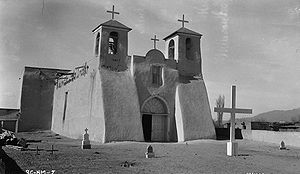
Ranchos de Taos, New Mexico
Ranchos de Taos is a census-designated place in Taos County, New Mexico, United States. The population was 2,390 at the 2000 census.-Geography:Ranchos de Taos is located at ....
, symbolically it ends at the famous San Francisco de Asis Mission Church
San Francisco de Asis Mission Church
San Francisco de Asis Mission Church is a church built between 1772 and 1816. It is located on the plaza in Ranchos de Taos, itself a historic district named Ranchos de Taos Plaza, about four miles southwest of the town of Taos, New Mexico....
a few blocks south. This is probably one of the most painted and photographed churches in the nation—especially the buttresses in the back, famously painted by Georgia O'Keeffe
Georgia O'Keeffe
Georgia Totto O'Keeffe was an American artist.Born near Sun Prairie, Wisconsin, O'Keeffe first came to the attention of the New York art community in 1916, several decades before women had gained access to art training in America’s colleges and universities, and before any of its women artists...
and photographed by Paul Strand
Paul Strand
Paul Strand was an American photographer and filmmaker who, along with fellow modernist photographers like Alfred Stieglitz and Edward Weston, helped establish photography as an art form in the 20th century...
and Ansel Adams
Ansel Adams
Ansel Easton Adams was an American photographer and environmentalist, best known for his black-and-white photographs of the American West, especially in Yosemite National Park....
. Completion of its construction took from 1772 to 1815.
External links
- High Road to Taos visitor and art guide
- New Mexico Tourism site on High Road to Taos Scenic Byway
- Video on the High Road to Taos Scenic Byway, produced by the New Mexico Tourism Department
- Taos Visitor Center guide to the High Road to Taos
- Moon Travel Guides article
- Article with photos
- Article from Sunset magazine