

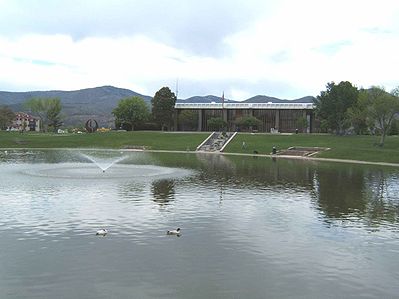
Los Alamos, New Mexico
Encyclopedia
Townsite
A townsite is a legal subdivision of land for the development of a town or community. In the historical development of the United States, Canada, and other former British colonial nations, the filing of a townsite plat or plan was often the first legal act in the establishment of a new town or...
and census-designated place
Census-designated place
A census-designated place is a concentration of population identified by the United States Census Bureau for statistical purposes. CDPs are delineated for each decennial census as the statistical counterparts of incorporated places such as cities, towns and villages...
(CDP) in Los Alamos County
Los Alamos County, New Mexico
-2010:Whereas according to the 2010 U.S. Census Bureau:*87.8% White*0.6% Black*0.8% Native American*6.0% Asian*0.0% Native Hawaiian or Pacific Islander*2.6% Two or more races*2.2% Other races*14.7% Hispanic or Latino -2000:...
, New Mexico
New Mexico
New Mexico is a state located in the southwest and western regions of the United States. New Mexico is also usually considered one of the Mountain States. With a population density of 16 per square mile, New Mexico is the sixth-most sparsely inhabited U.S...
, United States
United States
The United States of America is a federal constitutional republic comprising fifty states and a federal district...
, built upon four mesas of the Pajarito Plateau
Pajarito Plateau
The Pajarito Plateau is a volcanic plateau in north central New Mexico, United States. The plateau, part of the Jemez Mountains, is bounded on the west by the Valles Caldera and on the east by the White Rock Canyon of the Rio Grande...
and the adjoining White Rock Canyon. The population of the CDP was 12,019 at the 2010 Census
2010 census
The following countries conducted a census in 2010:* Sixth National Population Census of the People's Republic of China* Russian Census * 2010 United States Census...
. The townsite or "the hill" is one part of town while White Rock
White Rock, New Mexico
White Rock is a census-designated place in Los Alamos County, New Mexico, United States. The population was 6,045 at the 2000 census. It is largely a bedroom community for employees of Los Alamos National Laboratory and their families...
is also part of the town. Technically, both are part of the same incorporated city/county. Los Alamos is home to the Los Alamos National Laboratory
Los Alamos National Laboratory
Los Alamos National Laboratory is a United States Department of Energy national laboratory, managed and operated by Los Alamos National Security , located in Los Alamos, New Mexico...
, which was founded to undertake the Manhattan Project
Manhattan Project
The Manhattan Project was a research and development program, led by the United States with participation from the United Kingdom and Canada, that produced the first atomic bomb during World War II. From 1942 to 1946, the project was under the direction of Major General Leslie Groves of the US Army...
. Los Alamos County is an incorporated
Municipal corporation
A municipal corporation is the legal term for a local governing body, including cities, counties, towns, townships, charter townships, villages, and boroughs. Municipal incorporation occurs when such municipalities become self-governing entities under the laws of the state or province in which...
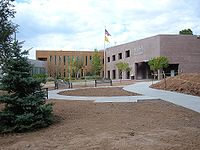
county, and many county offices are located at the townsite of Los Alamos. Los Alamos High School
Los Alamos High School
Los Alamos High School, often called LAHS, is the public high school in Los Alamos, New Mexico, USA. The school opened in 1946, and was originally supported by the Atomic Energy Commission. It has been academically recognized by Newsweek, U.S. News & World Report, and the New Mexico Public...
is the public high school of Los Alamos County. Before the Manhattan Project, the site was occupied by the Los Alamos Ranch School
Los Alamos Ranch School
Los Alamos Ranch School was a private boarding school for boys in Los Alamos County, New Mexico, near Otowi, in what would eventually become Los Alamos, New Mexico...
. Los Alamos has a county council which the people elect to four-year terms. The county council is seven members with four or three persons elected every two years to the four-year terms. The council elects a chairman and vice-chairman.
History
Los Alamos is built on the Pajarito Plateau between White Rock Canyon and the Valles Caldera. The mesas that the townsite resides on were created by glacial erosion during the last ice age.The first settlers on the plateau are thought to be Keres
Keresan languages
Keresan , also Keres , is a group of seven related languages spoken by Keres Pueblo peoples in New Mexico, U.S.A.. Each is mutually intelligible with its closest neighbors...
speaking Indians around the 10th Century AD. Around 1300 AD, Tewa settlers immigrated from the Four Corners Region and build large cities but were driven out within 50 years by Navajo
Navajo people
The Navajo of the Southwestern United States are the largest single federally recognized tribe of the United States of America. The Navajo Nation has 300,048 enrolled tribal members. The Navajo Nation constitutes an independent governmental body which manages the Navajo Indian reservation in the...
and Apache
Apache
Apache is the collective term for several culturally related groups of Native Americans in the United States originally from the Southwest United States. These indigenous peoples of North America speak a Southern Athabaskan language, which is related linguistically to the languages of Athabaskan...
raids and by drought. Both the Keres and Tewa towns can be seen today in the ruins of Bandelier National Monument
Bandelier National Monument
Bandelier National Monument is a National Monument preserving the homes of the Ancestral Pueblo People. It is named after Swiss anthropologist Adolph Bandelier, who researched the cultures of the area. Bandelier was designated a National Monument on February 11, 1916, and most of its backcountry...
and Tsankawi.
The land of the plateau was then divided up for homesteading. Most residents of the plateau built simple log cabins that were only resided in during warm weather to feed livestock, with the homesteaders moving down to the warmer Rio Grande Valley
Rio Grande Valley
The Rio Grande Valley or the Lower Rio Grande Valley, informally called The Valley, is an area located in the southernmost tip of South Texas...
. Homesteader Harold H. Brook sold part of his land and buildings to Detroit businessman Ashley Pond in 1917 which began the Los Alamos Ranch School, named after the cottonwood trees that blossomed in the fall. The school lasted for 25 years, when the Department of Defense
United States Department of Defense
The United States Department of Defense is the U.S...
was looking for a remote location for the Manhattan Project
Manhattan Project
The Manhattan Project was a research and development program, led by the United States with participation from the United Kingdom and Canada, that produced the first atomic bomb during World War II. From 1942 to 1946, the project was under the direction of Major General Leslie Groves of the US Army...
during World War II
World War II
World War II, or the Second World War , was a global conflict lasting from 1939 to 1945, involving most of the world's nations—including all of the great powers—eventually forming two opposing military alliances: the Allies and the Axis...
.
In 1942 the government used its power of eminent domain to take over the Ranch School and all the remaining homesteads. The Ranch School was paid $225 per acre while the homesteaders were paid only between $7 and $15 per acre. All information about the town was highly classified until the bombing of Hiroshima
Atomic bombings of Hiroshima and Nagasaki
During the final stages of World War II in 1945, the United States conducted two atomic bombings against the cities of Hiroshima and Nagasaki in Japan, the first on August 6, 1945, and the second on August 9, 1945. These two events are the only use of nuclear weapons in war to date.For six months...
.
All incoming truckloads were labeled as common items to conceal the true nature of their contents, and any outbound correspondence by those working and living in Los Alamos was censored by military officials. At the time, it was referred to as "The Hill" by many in Santa Fe, and as "Site Y" by military personnel. The mailing address for all of Los Alamos was PO Box 1663, Santa Fe, NM. After the Manhattan Project completed, White Rock was abandoned until 1963 when people began to re-inhabit and rebuild new homes and buildings.
Los Alamos National Laboratory
Los Alamos National Laboratory
Los Alamos National Laboratory is a United States Department of Energy national laboratory, managed and operated by Los Alamos National Security , located in Los Alamos, New Mexico...
was established as a research government facility under the Department of Energy
United States Department of Energy
The United States Department of Energy is a Cabinet-level department of the United States government concerned with the United States' policies regarding energy and safety in handling nuclear material...
.
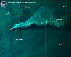
In 2000, a 48,000 acre wildfire, Cerro Grande Fire
Cerro Grande Fire
The Cerro Grande Fire was a disastrous forest fire in New Mexico, United States of America that occurred in May 2000. The fire started as a controlled burn, and became uncontrolled owing to high winds and drought conditions. Over 400 families in the town of Los Alamos, New Mexico lost their homes...
, tore through the townsite after the Park Service lit a controlled blaze in a high wind situation. The town was evacuated for 8 days while firefighters from all over the country battled the blaze, but over 400 homes were lost. FEMA built temporary housing for those that were displaced by the fire on North Mesa near the Middle School. It was nicknamed FEMA-ville. After the fires, there was widespread flooding due to the removal of the groundcover by the fire.
In the summer of 2011, the Las Conchas Fire
Las Conchas Fire
The Las Conchas Fire was a 2011 wildfire in New Mexico, USA. The fire started in Santa Fe National Forest and burned more than 150,000 acres, threatening Los Alamos National Laboratory and the town of Los Alamos...
broke out in the mountains southwest of the town, prompting a mandatory evacuation from the town and temporary closure of LANL. No buildings or structures in Los Alamos County were damaged by the fire.
Geography
Los Alamos is located at 35°53′28"N 106°17′52"W (35.891086, -106.297727), approximately 35 miles (56 km) to the northwest of Santa FeSanta Fe, New Mexico
Santa Fe is the capital of the U.S. state of New Mexico. It is the fourth-largest city in the state and is the seat of . Santa Fe had a population of 67,947 in the 2010 census...
. Elevation is 7320 feet.
According to the United States Census Bureau
United States Census Bureau
The United States Census Bureau is the government agency that is responsible for the United States Census. It also gathers other national demographic and economic data...
, the CDP has a total area of 10.9 square miles (28.2 km²), all of it land.
The town of Los Alamos is divided up across four mesas—Barranca Mesa, North Mesa, Los Alamos Mesa and South Mesa—along with the connecting communities at the base of the mountain. The Lab also occupies half of South Mesa, Two Mile Mesa, Frijoles Mesa, Mesita de Buey and several nearby areas in the region (in the valleys and at the base of the mountain). White Rock lies at the top of White Rock Canyon. There are three access roads between White Rock and Los Alamos—Main Hill Road, Jemez Road and Pajarito Road. Since 9-11, Pajarito Road has been restricted to LANL badge holders for security reasons.
Demographics
As of the censusCensus
A census is the procedure of systematically acquiring and recording information about the members of a given population. It is a regularly occurring and official count of a particular population. The term is used mostly in connection with national population and housing censuses; other common...
of 2000, there were 11,909 people, 5,110 households, and 3,372 families residing in the CDP. The population density
Population density
Population density is a measurement of population per unit area or unit volume. It is frequently applied to living organisms, and particularly to humans...
was 1096.2 PD/sqmi. There were 5,463 housing units at an average density of 502.8 /sqmi. The racial makeup of the CDP was 89.13% White, 0.44% African American, 0.56% Native American, 4.47% Asian, 0.04% Pacific Islander, 3.01% from other races
Race (United States Census)
Race and ethnicity in the United States Census, as defined by the Federal Office of Management and Budget and the United States Census Bureau, are self-identification data items in which residents choose the race or races with which they most closely identify, and indicate whether or not they are...
, and 2.35% from two or more races. Hispanic or Latino of any race were 12.21% of the population.
Bachelor's degree
A bachelor's degree is usually an academic degree awarded for an undergraduate course or major that generally lasts for three or four years, but can range anywhere from two to six years depending on the region of the world...
or higher (2000 Census).
There were 5,110 households out of which 31.4% had children under the age of 18 living with them, 56.4% were married couples
Marriage
Marriage is a social union or legal contract between people that creates kinship. It is an institution in which interpersonal relationships, usually intimate and sexual, are acknowledged in a variety of ways, depending on the culture or subculture in which it is found...
living together, 6.5% had a female householder with no husband present, and 34.0% were non-families. 29.8% of all households were made up of individuals and 7.6% had someone living alone who was 65 years of age or older. The average household size was 2.31 and the average family size was 2.89.
In the CDP the population was spread out with 24.8% under the age of 18, 4.8% from 18 to 24, 29.2% from 25 to 44, 28.2% from 45 to 64, and 12.9% who were 65 years of age or older. The median age was 40 years. For every 100 females there were 101.3 males. For every 100 females age 18 and over, there were 100.1 males.
The median income for a household in the CDP was $71,536, and the median income for a family was $86,876. Males had a median income of $65,638 versus $39,352 for females. The per capita income
Per capita income
Per capita income or income per person is a measure of mean income within an economic aggregate, such as a country or city. It is calculated by taking a measure of all sources of income in the aggregate and dividing it by the total population...
for the CDP was $34,240. About 2.4% of families and 3.6% of the population were below the poverty line, including 2.6% of those under age 18 and 5.3% of those age 65 or over. 11.7% of Los Alamos citizen are millionaires, the highest rate in the country.
The home ownership rate (owner-occupied housing units to total units) is 71.5%. After the Manhattan Project, the first sale of a private home in Los Alamos was made in 1965 by the US Government to William Overton, who bought a house on Manhattan Loop.
VLBA node
The radio telescopeRadio telescope
A radio telescope is a form of directional radio antenna used in radio astronomy. The same types of antennas are also used in tracking and collecting data from satellites and space probes...
located in Los Alamos is one of ten dishes composing the Very Long Baseline Array
Very Long Baseline Array
The Very Long Baseline Array is a system of ten radio telescopes controlled remotely from the Array Operations Center in Socorro, New Mexico by the National Radio Astronomy Observatory. The array works together as the world's largest dedicated, full-time astronomical instrument using the...
(VLBA).
City and regional partnership
Los Alamos maintains sister city status with the following international location:| City | Country | Sister City since |
|---|---|---|
| Sarov Sarov Sarov is a closed town in Nizhny Novgorod Oblast, Russia. Until 1995 it was known as Kremlyov ., while from 1946 to 1991 it was called Arzamas-16 . The town is off limits to foreigners as it is the Russian center for nuclear research. Population: -History:The history of the town can be divided... |
1993 |
Wildfires
- 1954 Water Canyon FireWater Canyon FireThe Water Canyon Fire of 1954 was a wildfire in the eastern edge of the Jemez Mountains and the Santa Fe National Forest which burned approximately 3,000 to 6,000 acres . The fire started on June 5, 1954 when the burning of trash and construction debris in upper Water Canyon got out of control...
- 1977 La Mesa FireLa Mesa FireThe La Mesa Fire was a wildfire on the Pajarito Plateau of New Mexico, USA, that was human-caused on the afternoon of June 16, 1977. Before it was contained one week later, the fire burned 15,444 acres of Bandelier National Monument and part of Los Alamos National Laboratory, where it reached...
- 1996 Dome FireDome FireThe Dome Fire was a destructive wildfire in the Jemez Mountains in the northern portion of the U.S. state of New Mexico. Devastating portions of the Santa Fe National Forest and Bandelier National Monument, the fire exploded on April 26, 1996, starting from an improperly extinguished campfire and...
- 1998 Oso Complex FireOso Complex FireThe Oso Complex Fire started June 20, 1998 and burned 5,185 acres in the Santa Fe National Forest in the Jemez Mountains, including more than 1,200 acres of Santa Clara Pueblo land. The fire came within 8 miles of Los Alamos, New Mexico and was contained by July 6, 1998, aided by rain...
- 2000 Cerro Grande FireCerro Grande FireThe Cerro Grande Fire was a disastrous forest fire in New Mexico, United States of America that occurred in May 2000. The fire started as a controlled burn, and became uncontrolled owing to high winds and drought conditions. Over 400 families in the town of Los Alamos, New Mexico lost their homes...
- 2011 Las Conchas FireLas Conchas FireThe Las Conchas Fire was a 2011 wildfire in New Mexico, USA. The fire started in Santa Fe National Forest and burned more than 150,000 acres, threatening Los Alamos National Laboratory and the town of Los Alamos...