
Hennepin County, Minnesota
Encyclopedia
Hennepin County is a county located in the U.S. state
of Minnesota
, named in honor of the 17th-century explorer Father Louis Hennepin
. As of 2010 the population was 1,152,425. Its county seat
is Minneapolis
. It is by far the most populous county in Minnesota; more than one in five Minnesotans live in Hennepin County. The center of population
of Minnesota is located in Hennepin County, in the city of Rogers
.
's name was chosen because he originally named St. Anthony Falls and recorded some of the earliest accounts of the area for the Western world. Hennepin County's early history is closely linked to the establishment of the cities of Minneapolis and St. Anthony.
 Like all counties in Minnesota, Hennepin is governed by an elected and nonpartisan
board of commissioners. In Minnesota, county commissions usually have five members, but Hennepin, Ramsey
, and St Louis
counties have seven members. Each commissioner represents a district of equal population. In Hennepin the county commission appoints the medical examiner
, county auditor-treasurer
and county recorder. The sheriff
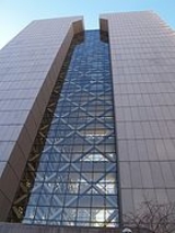
and county attorney are also elected on a nonpartisan ticket. The county government's headquarters are in downtown
Minneapolis
in the Hennepin County Government Center
. The county oversees the Hennepin County Library
system (which merged with the Minneapolis Public Library
system in 2008), and Hennepin County Medical Center
.
The county commission elects a chair who presides at meetings.
Commissioners as of May 2011
on the Mississippi River
, the Saint Anthony Falls
, discovered by Louis Hennepin, is in Hennepin County next to downtown Minneapolis, but in the 19th century, the falls were converted to a series of dam
s. Barges and boats now pass through locks to move between the parts of the river above and below the dams.
 As of the census
² of 2000, there were 1,116,200 people, 456,129 households, and 267,291 families residing in the county. The population density
was 774/km² (2,005/mi²). There were 468,824 housing units at an average density of 325/km² (842/mi²). The racial makeup of the county was 80.53% White
, 8.95% Black
or African American
, 1.00% Native American
, 4.80% Asian
, 0.05% Pacific Islander
, 2.06% from other races
, and 2.60% from two or more races. 4.07% of the population were Hispanic
or Latino
of any race. 22.8% were of German, 12.0% Norwegian, 7.6% Irish
and 7.2% Swedish ancestry according to Census 2000.
There were 456,129 households out of which 28.80% had children under the age of 18 living with them, 45.30% were married couples
living together, 9.90% had a female householder with no husband present, and 41.40% were non-families. 31.80% of all households were made up of individuals and 8.40% had someone living alone who was 65 years of age or older. The average household size was 2.39 and the average family size was 3.07.
In the county the population was spread out with 24.00% under the age of 18, 9.70% from 18 to 24, 33.70% from 25 to 44, 21.70% from 45 to 64, and 11.00% who were 65 years of age or older. The median age was 35 years. For every 100 females there were 97.00 males. For every 100 females age 18 and over, there were 94.70 males.
The median income for a household in the county was $51,711, and the median income for a family was $65,985 (these figures had risen to $60,115 and $79,970 respectively as of a 2007 estimate). Males had a median income of $42,466 versus $32,400 for females. The per capita income
for the county was $28,789. About 5.00% of families and 8.30% of the population were below the poverty line, including 10.50% of those under age 18 and 5.90% of those age 65 or over.
Hennepin County is the wealthiest county in the state of Minnesota and one of the 100 Highest-income counties in the United States
.
Foreign languages spoken by major immigrant groups in Hennepin County include Arabic
, Hmong
, Khmer
, Lao
, Russian
, Somali
, Spanish
, and Vietnamese
.
† While mostly in Hennepin County, the city extends beyond the county border.
‡ Located in another county, but a part of the city extends into Hennepin County.
within the county to fund the majority of the cost for a baseball
stadium for the Minnesota Twins
. Legislation passed by the Minnesota Legislature
in the waning hours of the 2005-2006 session, and signed by Governor Tim Pawlenty
, authorized the county to levy the tax without a voter referendum. It also created the Minnesota Ballpark Authority which constructed and manages the stadium on behalf of the county. The tax will be in effect for 30 years, with clauses allowing it to be increased by the board of commissioners. The stadium, Target Field
, opened in April 2010.
----
U.S. state
A U.S. state is any one of the 50 federated states of the United States of America that share sovereignty with the federal government. Because of this shared sovereignty, an American is a citizen both of the federal entity and of his or her state of domicile. Four states use the official title of...
of Minnesota
Minnesota
Minnesota is a U.S. state located in the Midwestern United States. The twelfth largest state of the U.S., it is the twenty-first most populous, with 5.3 million residents. Minnesota was carved out of the eastern half of the Minnesota Territory and admitted to the Union as the thirty-second state...
, named in honor of the 17th-century explorer Father Louis Hennepin
Louis Hennepin
Father Louis Hennepin, O.F.M. baptized Antoine, was a Catholic priest and missionary of the Franciscan Recollect order and an explorer of the interior of North America....
. As of 2010 the population was 1,152,425. Its county seat
County seat
A county seat is an administrative center, or seat of government, for a county or civil parish. The term is primarily used in the United States....
is Minneapolis
Minneapolis, Minnesota
Minneapolis , nicknamed "City of Lakes" and the "Mill City," is the county seat of Hennepin County, the largest city in the U.S. state of Minnesota, and the 48th largest in the United States...
. It is by far the most populous county in Minnesota; more than one in five Minnesotans live in Hennepin County. The center of population
Center of population
In demographics, the center of population of a region is a geographical point that describes a centerpoint of the region's population...
of Minnesota is located in Hennepin County, in the city of Rogers
Rogers, Minnesota
As of the census of 2000, there were 3,588 people, 1,195 households, and 982 families residing in the city. The population density was 715.1 people per square mile . There were 1,245 housing units at an average density of 248.1 per square mile...
.
History
Hennepin County was created in 1852 by the Minnesota Territorial Legislature. Father Louis HennepinLouis Hennepin
Father Louis Hennepin, O.F.M. baptized Antoine, was a Catholic priest and missionary of the Franciscan Recollect order and an explorer of the interior of North America....
's name was chosen because he originally named St. Anthony Falls and recorded some of the earliest accounts of the area for the Western world. Hennepin County's early history is closely linked to the establishment of the cities of Minneapolis and St. Anthony.
Law and government
Nonpartisan
In political science, nonpartisan denotes an election, event, organization or person in which there is no formally declared association with a political party affiliation....
board of commissioners. In Minnesota, county commissions usually have five members, but Hennepin, Ramsey
Ramsey County, Minnesota
Ramsey County is a county located in the U.S. state of Minnesota, founded in 1849. As of 2010, the population was 508,640. Its county seat is St. Paul, which is also Minnesota's state capital. The county is named for Alexander Ramsey , the first governor of the Minnesota Territory...
, and St Louis
St. Louis County, Minnesota
St. Louis County is a county located in the U.S. state of Minnesota. As of 2010, the population was 200,226. Its county seat is Duluth. It is the largest county by total area in Minnesota, and the second largest in the United States east of the Mississippi River; in land area alone, after Aroostook...
counties have seven members. Each commissioner represents a district of equal population. In Hennepin the county commission appoints the medical examiner
Medical examiner
A medical examiner is a medically qualified government officer whose duty is to investigate deaths and injuries that occur under unusual or suspicious circumstances, to perform post-mortem examinations, and in some jurisdictions to initiate inquests....
, county auditor-treasurer
Treasurer
A treasurer is the person responsible for running the treasury of an organization. The adjective for a treasurer is normally "tresorial". The adjective "treasurial" normally means pertaining to a treasury, rather than the treasurer.-Government:...
and county recorder. The sheriff
Sheriff
A sheriff is in principle a legal official with responsibility for a county. In practice, the specific combination of legal, political, and ceremonial duties of a sheriff varies greatly from country to country....
and county attorney are also elected on a nonpartisan ticket. The county government's headquarters are in downtown
Downtown
Downtown is a term primarily used in North America by English speakers to refer to a city's core or central business district ....
Minneapolis
Minneapolis, Minnesota
Minneapolis , nicknamed "City of Lakes" and the "Mill City," is the county seat of Hennepin County, the largest city in the U.S. state of Minnesota, and the 48th largest in the United States...
in the Hennepin County Government Center
Hennepin County Government Center
The Hennepin County Government Center is the courthouse and primary county government administration building for Hennepin County in the State of Minnesota. It is located in downtown Minneapolis, Minnesota, the county seat of Hennepin County...
. The county oversees the Hennepin County Library
Hennepin County Library
Hennepin County Library is a library system serving the entire population of Hennepin County, Minnesota, USA. The Minneapolis Public Library, a separate system for Minneapolis, existed from its founding by T. B. Walker in 1885 until January 2008...
system (which merged with the Minneapolis Public Library
Minneapolis Public Library
The Minneapolis Public Library and Information Center was a library system serving the residents of Minneapolis, Minnesota in the United States. It was founded as the publicly traded Minneapolis Athenæum in 1860 and became a free public library in 1885 founded by T. B. Walker...
system in 2008), and Hennepin County Medical Center
Hennepin County Medical Center
Hennepin County Medical Center is a Level I trauma center based in Minneapolis, Minnesota, the county seat of Hennepin County. The primary 422-bed facility is located on five city blocks across the street from the Hubert H. Humphrey Metrodome, with satellite clinics in Minneapolis, Brooklyn...
.
The county commission elects a chair who presides at meetings.
Commissioners as of May 2011
| District | Commissioner | In office since | Current term expires in January |
|---|---|---|---|
| 1st | Mike Opat Mike Opat Michael Joseph Opat is an American politician from the U.S. state of Minnesota. He serves as the Chair of the Hennepin County Board of Commissioners, the governing body for the largest county in Minnesota, with more than 1.1 million residents and an annual budget of $1.7 billion... (chair) |
1993 | 2015 |
| 2nd | Mark Stenglein | 1997 | 2015 |
| 3rd | Gail Dorfman | 1999 | 2015 |
| 4th | Peter McLaughlin | 1991 | 2015 |
| 5th | Randy Johnson Randy Johnson (council member) Randy Johnson represents the 5th District of Hennepin County government in Minnesota. Hennepin County is the largest of Minnesota's 87 counties in population, budget and estimated value. Hennepin County's population is 1.1 million, which is 21 percent of the state's total population, and about one... |
1979 | 2013 |
| 6th | Jan Callison | 2009 | 2013 |
| 7th | Jeff Johnson | 2009 | 2013 |
Key staff
Hennepin County's normal operations are coordinated by the County Administrator Richard Johnson, Deputy County Administrator David Hough, Assistant County Administrator for Human Services and Public Health Dan Engstrom, and Assistant County Administrator for Public Works Marthand Nookala.Geography
According to the 2000 census, the county has a total area of 606.38 square miles (1,570.5 km²), of which 556.62 square miles (1,441.6 km²) (or 91.79%) is land and 49.77 square miles (128.9 km²) (or 8.21%) is water. The highest waterfallWaterfall
A waterfall is a place where flowing water rapidly drops in elevation as it flows over a steep region or a cliff.-Formation:Waterfalls are commonly formed when a river is young. At these times the channel is often narrow and deep. When the river courses over resistant bedrock, erosion happens...
on the Mississippi River
Mississippi River
The Mississippi River is the largest river system in North America. Flowing entirely in the United States, this river rises in western Minnesota and meanders slowly southwards for to the Mississippi River Delta at the Gulf of Mexico. With its many tributaries, the Mississippi's watershed drains...
, the Saint Anthony Falls
Saint Anthony Falls
Saint Anthony Falls, or the Falls of Saint Anthony, located northeast of downtown Minneapolis, Minnesota, was the only natural major waterfall on the Upper Mississippi River. The natural falls was replaced by a concrete overflow spillway after it partially collapsed in 1869...
, discovered by Louis Hennepin, is in Hennepin County next to downtown Minneapolis, but in the 19th century, the falls were converted to a series of dam
Dam
A dam is a barrier that impounds water or underground streams. Dams generally serve the primary purpose of retaining water, while other structures such as floodgates or levees are used to manage or prevent water flow into specific land regions. Hydropower and pumped-storage hydroelectricity are...
s. Barges and boats now pass through locks to move between the parts of the river above and below the dams.
Major highways
|
 Minnesota State Highway 55 Minnesota State Highway 55Minnesota State Highway 55 Minnesota State Highway 55 is a highway in west-central, central, and east-central Minnesota, which runs from the North Dakota state line near Tenney and continues east and southeast to its eastern terminus at its intersection with U.S...  Minnesota State Highway 62 Minnesota State Highway 62Minnesota State Highway 62 (east) Minnesota State Highway 62 is a highway in the Twin Cities region of Minnesota. The route was part of Hennepin County Road 62 until 1988, when a portion of the route was inherited by the state. The western terminus of the route is at Interstate Highway 494 in Eden Prairie, where the roadway...  Minnesota State Highway 65 Minnesota State Highway 65Minnesota State Highway 65 Minnesota State Highway 65 is a highway in east-central and northeast Minnesota, which runs from its intersection with Washington Avenue at the north end of downtown Minneapolis and continues north to its northern terminus at its intersection with U.S...  Minnesota State Highway 77 Minnesota State Highway 77Minnesota State Highway 77 Minnesota State Highway 77 is a highway in Minnesota, which runs from its intersection with 138th Street in Apple Valley and continues north to its northern terminus at its interchange with State Highway 62 in Minneapolis. The route is in length...  Minnesota State Highway 100 Minnesota State Highway 100Minnesota State Highway 100 Minnesota State Highway 100 is a state highway in the Twin Cities region of Minnesota, which runs from its interchange with Interstate 494 in Bloomington and continues north to its northern terminus at its interchange with I-694 in Brooklyn Center...  Minnesota State Highway 101 Minnesota State Highway 101Minnesota State Highway 101 Minnesota State Highway 101 is a state highway in the U.S. state of Minnesota. The present day route currently has two separate segments. The roadway was a continuous route until 1988.-Route description:...  Minnesota State Highway 121 Minnesota State Highway 121Minnesota State Highway 121 Minnesota State Highway 121 is a short freeway stub in Minnesota. It is less than one mile in length.Highway 121 runs between Interstate Highway 35W in Richfield and Lyndale Avenue South in Minneapolis where it intersects West 58th Street...  Minnesota State Highway 312 Minnesota State Highway 312 Minnesota State Highway 252 Minnesota State Highway 252Minnesota State Highway 252 Minnesota State Highway 252 is a highway in Minnesota, which runs from its interchange with Interstate Highways 94 and 694 in Brooklyn Center and continues north to its northern terminus at its interchange with State Highway 610 in Brooklyn Park...  Minnesota State Highway 280 Minnesota State Highway 280Minnesota State Highway 280 Minnesota State Highway 280 is a highway in the Twin Cities region of Minnesota, which runs from its interchange with Interstate 94 in Saint Paul and continues north to its interchange with Interstate 35W in Roseville...  Minnesota State Highway 610 Minnesota State Highway 610Minnesota State Highway 610 Minnesota State Highway 610 is an east–west freeway in the Twin Cities region of Minnesota; located in northern Hennepin County and southern Anoka County. The freeway currently connects U.S. Highway 169 and U.S. Highway 10 . MN 610 crosses the Mississippi River on the Richard P. Braun... |


 U.S. Highway 12
 U.S. Highway 52
 U.S. Highway 169
 U.S. Highway 212


Adjacent counties
- Anoka CountyAnoka County, MinnesotaAnoka County is the fourth-most populous county in the U.S. state of Minnesota. The county is bordered by the counties of Isanti on the north, Chisago and Washington on the east, Hennepin and Ramsey on the south, Sherburne on the west, and the Mississippi River on the southwest.As of 2010, Anoka...
(northeast) - Ramsey CountyRamsey County, MinnesotaRamsey County is a county located in the U.S. state of Minnesota, founded in 1849. As of 2010, the population was 508,640. Its county seat is St. Paul, which is also Minnesota's state capital. The county is named for Alexander Ramsey , the first governor of the Minnesota Territory...
(east) - Dakota CountyDakota County, MinnesotaDakota County is the third most populous county in the U.S. state of Minnesota. The county is bordered by the Minnesota and Mississippi Rivers on the north, and the state of Wisconsin on the east. Dakota County comprises the southeast portion of seven-county Minneapolis-St. Paul, the thirteenth...
(southeast) - Scott CountyScott County, MinnesotaScott County is a county located in the U.S. state of Minnesota. It was organized in 1853 and named in honor of General Winfield Scott. As of 2010, the population was 129,928. Its county seat is Shakopee...
(south) - Carver CountyCarver County, MinnesotaAs of the census of 2000, there were 70,205 people, 24,356 households, and 18,778 families residing in the county. The population density was 197 people per square mile . There were 24,883 housing units at an average density of 70 per square mile...
(southwest) - Wright CountyWright County, MinnesotaWright County is a county located in the U.S. state of Minnesota, founded in 1855. As of 2010, the population was 124,700. Its county seat is Buffalo.-History:...
(northwest)
National protected areas
- Minnesota Valley National Wildlife RefugeMinnesota Valley National Wildlife RefugeThe Minnesota Valley National Wildlife Refuge is a 14,000 acre National Wildlife Refuge in central Minnesota. There are eight refuge units strung along of the Minnesota River. Located just south of the city of Minneapolis, this is one of only four American national wildlife refuges in an urban...
(part) - Mississippi National River and Recreation AreaMississippi National River and Recreation AreaThe Mississippi National River and Recreation Area protects a and corridor along the Mississippi River from the cities of Dayton and Ramsey, Minnesota to just downstream of Hastings, Minnesota. This includes the stretch of Mississippi River which flows through Minneapolis and St. Paul, Minnesota...
(part)
Demographics
Census
A census is the procedure of systematically acquiring and recording information about the members of a given population. It is a regularly occurring and official count of a particular population. The term is used mostly in connection with national population and housing censuses; other common...
² of 2000, there were 1,116,200 people, 456,129 households, and 267,291 families residing in the county. The population density
Population density
Population density is a measurement of population per unit area or unit volume. It is frequently applied to living organisms, and particularly to humans...
was 774/km² (2,005/mi²). There were 468,824 housing units at an average density of 325/km² (842/mi²). The racial makeup of the county was 80.53% White
Race (United States Census)
Race and ethnicity in the United States Census, as defined by the Federal Office of Management and Budget and the United States Census Bureau, are self-identification data items in which residents choose the race or races with which they most closely identify, and indicate whether or not they are...
, 8.95% Black
Race (United States Census)
Race and ethnicity in the United States Census, as defined by the Federal Office of Management and Budget and the United States Census Bureau, are self-identification data items in which residents choose the race or races with which they most closely identify, and indicate whether or not they are...
or African American
Race (United States Census)
Race and ethnicity in the United States Census, as defined by the Federal Office of Management and Budget and the United States Census Bureau, are self-identification data items in which residents choose the race or races with which they most closely identify, and indicate whether or not they are...
, 1.00% Native American
Race (United States Census)
Race and ethnicity in the United States Census, as defined by the Federal Office of Management and Budget and the United States Census Bureau, are self-identification data items in which residents choose the race or races with which they most closely identify, and indicate whether or not they are...
, 4.80% Asian
Race (United States Census)
Race and ethnicity in the United States Census, as defined by the Federal Office of Management and Budget and the United States Census Bureau, are self-identification data items in which residents choose the race or races with which they most closely identify, and indicate whether or not they are...
, 0.05% Pacific Islander
Race (United States Census)
Race and ethnicity in the United States Census, as defined by the Federal Office of Management and Budget and the United States Census Bureau, are self-identification data items in which residents choose the race or races with which they most closely identify, and indicate whether or not they are...
, 2.06% from other races
Race (United States Census)
Race and ethnicity in the United States Census, as defined by the Federal Office of Management and Budget and the United States Census Bureau, are self-identification data items in which residents choose the race or races with which they most closely identify, and indicate whether or not they are...
, and 2.60% from two or more races. 4.07% of the population were Hispanic
Race (United States Census)
Race and ethnicity in the United States Census, as defined by the Federal Office of Management and Budget and the United States Census Bureau, are self-identification data items in which residents choose the race or races with which they most closely identify, and indicate whether or not they are...
or Latino
Race (United States Census)
Race and ethnicity in the United States Census, as defined by the Federal Office of Management and Budget and the United States Census Bureau, are self-identification data items in which residents choose the race or races with which they most closely identify, and indicate whether or not they are...
of any race. 22.8% were of German, 12.0% Norwegian, 7.6% Irish
Irish people
The Irish people are an ethnic group who originate in Ireland, an island in northwestern Europe. Ireland has been populated for around 9,000 years , with the Irish people's earliest ancestors recorded having legends of being descended from groups such as the Nemedians, Fomorians, Fir Bolg, Tuatha...
and 7.2% Swedish ancestry according to Census 2000.
There were 456,129 households out of which 28.80% had children under the age of 18 living with them, 45.30% were married couples
Marriage
Marriage is a social union or legal contract between people that creates kinship. It is an institution in which interpersonal relationships, usually intimate and sexual, are acknowledged in a variety of ways, depending on the culture or subculture in which it is found...
living together, 9.90% had a female householder with no husband present, and 41.40% were non-families. 31.80% of all households were made up of individuals and 8.40% had someone living alone who was 65 years of age or older. The average household size was 2.39 and the average family size was 3.07.
In the county the population was spread out with 24.00% under the age of 18, 9.70% from 18 to 24, 33.70% from 25 to 44, 21.70% from 45 to 64, and 11.00% who were 65 years of age or older. The median age was 35 years. For every 100 females there were 97.00 males. For every 100 females age 18 and over, there were 94.70 males.
The median income for a household in the county was $51,711, and the median income for a family was $65,985 (these figures had risen to $60,115 and $79,970 respectively as of a 2007 estimate). Males had a median income of $42,466 versus $32,400 for females. The per capita income
Per capita income
Per capita income or income per person is a measure of mean income within an economic aggregate, such as a country or city. It is calculated by taking a measure of all sources of income in the aggregate and dividing it by the total population...
for the county was $28,789. About 5.00% of families and 8.30% of the population were below the poverty line, including 10.50% of those under age 18 and 5.90% of those age 65 or over.
Hennepin County is the wealthiest county in the state of Minnesota and one of the 100 Highest-income counties in the United States
Highest-income counties in the United States
There are 3,141 counties in the United States. The source of the data is the U.S. Census Bureau and the data is current as of the indicated year. Independent cities are considered county-equivalent by the Census Bureau.-2011:...
.
Foreign languages spoken by major immigrant groups in Hennepin County include Arabic
Arabic language
Arabic is a name applied to the descendants of the Classical Arabic language of the 6th century AD, used most prominently in the Quran, the Islamic Holy Book...
, Hmong
Hmong language
Hmong or Mong is the common name for a dialect continuum of the West Hmongic branch of the Hmong–Mien/Miao–Yao language family spoken by the Hmong people of Sichuan, Yunnan, Guizhou, Guangxi, northern Vietnam, Thailand, and Laos...
, Khmer
Khmer language
Khmer , or Cambodian, is the language of the Khmer people and the official language of Cambodia. It is the second most widely spoken Austroasiatic language , with speakers in the tens of millions. Khmer has been considerably influenced by Sanskrit and Pali, especially in the royal and religious...
, Lao
Lao language
Lao or Laotian is a tonal language of the Tai–Kadai language family. It is the official language of Laos, and also spoken in the northeast of Thailand, where it is usually referred to as the Isan language. Being the primary language of the Lao people, Lao is also an important second language for...
, Russian
Russian language
Russian is a Slavic language used primarily in Russia, Belarus, Uzbekistan, Kazakhstan, Tajikistan and Kyrgyzstan. It is an unofficial but widely spoken language in Ukraine, Moldova, Latvia, Turkmenistan and Estonia and, to a lesser extent, the other countries that were once constituent republics...
, Somali
Somali language
The Somali language is a member of the East Cushitic branch of the Afro-Asiatic language family. Its nearest relatives are Afar and Oromo. Somali is the best documented of the Cushitic languages, with academic studies beginning before 1900....
, Spanish
Spanish language
Spanish , also known as Castilian , is a Romance language in the Ibero-Romance group that evolved from several languages and dialects in central-northern Iberia around the 9th century and gradually spread with the expansion of the Kingdom of Castile into central and southern Iberia during the...
, and Vietnamese
Vietnamese language
Vietnamese is the national and official language of Vietnam. It is the mother tongue of 86% of Vietnam's population, and of about three million overseas Vietnamese. It is also spoken as a second language by many ethnic minorities of Vietnam...
.
Cities and towns
| Cities | Townships | Unorganized | |
|---|---|---|---|
|
Medicine Lake, Minnesota Medicine Lake is a city in Hennepin County, Minnesota, United States. The population was 371 at the 2010 census.-Geography:According to the United States Census Bureau, the city has a total area of —0.2 square miles of it is land and of it is water... Medina, Minnesota Medina is a city in Hennepin County, Minnesota, United States. The population was 4,892 at the 2010 census.-Geography:According to the United States Census Bureau, the city has a total area of , of which, of it is land and of it is water... Minneapolis, Minnesota Minneapolis , nicknamed "City of Lakes" and the "Mill City," is the county seat of Hennepin County, the largest city in the U.S. state of Minnesota, and the 48th largest in the United States... Minnetonka, Minnesota As of the census of 2000, there were 51,301 people, 21,393 households, and 14,097 families residing in the city. The population density was 1,893.0 persons per square mile . There were 22,228 housing units at an average density of 818.9 per square mile... Minnetonka Beach, Minnesota As of the census of 2000, there were 614 people, 215 households, and 176 families residing in the city. The population density was 1,186.5 people per square mile . There were 224 housing units at an average density of 432.8 per square mile... Minnetrista, Minnesota Minnetrista is a settlement mainly in Hennepin County, Minnesota. A very small part of Minnetrista Extends into Carver County. The name Minnetrista is said to owe its origin to the Dakota language, in which minne means "water" and trista means "crooked." The city is generally rural and still has... Mound, Minnesota Mound is a settlement in Hennepin County, Minnesota, United States. ZIP code: 55364. The population was 9,052 at the 2010 census. Mound is the birthplace of the Tonka truck, named after Lake Minnetonka. Mound is also the birthplace of actor Kevin Sorbo, who portrayed Hercules on the television... New Hope, Minnesota As of the census of 2000, there were 20,873 people, 8,665 households, and 5,268 families residing in the city. The population density was 4,098.6 people per square mile . There were 8,746 housing units at an average density of 1,717.4 per square mile... Orono, Minnesota As of the census of 2000, there were 7,538 people, 2,766 households, and 2,196 families residing in the city. The population density was 468.9 people per square mile . There were 2,909 housing units at an average density of 181.0 per square mile... Osseo, Minnesota As of the census of 2000, there were 2,434 people, 1,035 households, and 606 families residing in the city. The population density was 3,179.7 people per square mile . There were 1,060 housing units at an average density of 1,384.7 per square mile... Plymouth, Minnesota As of the census of 2000, there were 65,894 people, 24,820 households, and 17,647 families residing in the city. The population density was 2,002.0 persons per square mile . There were 25,258 housing units at an average density of 767.4 per square mile... Richfield, Minnesota As of the census of 2000, there were 34,439 people, 15,073 households, and 8,727 families residing in the city. The population density was 4,993.9 people per square mile . There were 15,357 housing units at an average density of 2,226.9 per square mile... Robbinsdale, Minnesota Robbinsdale is a city in Hennepin County, Minnesota, United States. The population was 13,953 at the 2010 census.-Geography:According to the United States Census Bureau, the city has a total area of , of which, of it is land and of it is water.... Rockford, Minnesota As of the census of 2000, there were 3,484 people, 1,296 households, and 929 families residing in the city. The population density was 2,021.2 people per square mile . There were 1,333 housing units at an average density of 773.3 per square mile... ‡ Rogers, Minnesota As of the census of 2000, there were 3,588 people, 1,195 households, and 982 families residing in the city. The population density was 715.1 people per square mile . There were 1,245 housing units at an average density of 248.1 per square mile... Shorewood, Minnesota Shorewood is a settlement on Lake Minnetonka in Hennepin County, Minnesota, United States. The population was 7,307 at the 2010 census. The city was incorporated in 1956. Its area was originally part of the larger Excelsior Township as were the nearby cities of Excelsior, Tonka Bay and Deephaven... Spring Park, Minnesota Spring Park is a settlement on Lake Minnetonka in Hennepin County, Minnesota, United States. The population was 1,669 at the 2010 census. It is located on Lake Minnetonka and has over of shoreline while being less than in area. It was incorporated in 1951 and at that time had a population of a... St. Bonifacius, Minnesota St. Bonifacius is a settlement in Hennepin County, Minnesota. It is centered around Minnesota State Highway 7 and County Road 92, and located about 25 miles west of Minneapolis. It is part of the Waconia School District. The population was 2,283 at the 2010 census. Crown College is also located in... St. Louis Park, Minnesota As of the census of 2000, there were 44,126 people, 20,782 households, and 10,557 families residing in the city. The population density was 4,122.5 persons per square mile . There were 21,140 housing units at an average density of 1,975.0 per square mile... Tonka Bay, Minnesota Tonka Bay is a settlement in Hennepin County, Minnesota, United States. It is located on Lake Minnetonka between the upper and lower lakes. The population of Tonka Bay was 1,475 at the 2010 census.-History:... Wayzata, Minnesota Wayzata is a city in Hennepin County, Minnesota, United States, a western suburb of Minneapolis. Wayzata came into existence in the center of Chief Shakopee's Indian village.-Early settlement:... Woodland, Minnesota Woodland is a city in Hennepin County, Minnesota, United States, with lake shore property on Lake Minnetonka. The population was 437 at the 2010 census... |
Hassan Township, Minnesota Hassan Township is a urban township in Hennepin County, Minnesota, United States. Located in the northwestern corner of the county, it is the only township in the county... |
Fort Snelling, Minnesota Fort Snelling, originally known as Fort Saint Anthony, was a military fortification located at the confluence of the Minnesota River and Mississippi River in Hennepin County, Minnesota... |
† While mostly in Hennepin County, the city extends beyond the county border.
‡ Located in another county, but a part of the city extends into Hennepin County.
Colleges and universities
- Augsburg CollegeAugsburg CollegeAugsburg College is a selective liberal arts college of the Evangelical Lutheran Church in America located in Minneapolis, Minnesota. Augsburg was named for the Augsburg Confession, the document of Lutheran belief. The school was founded in 1869 in Marshall, Wisconsin as Augsburg Seminary and moved...
in Minneapolis - Dunwoody College of TechnologyDunwoody College of TechnologyDunwoody College of Technology is a private, non-profit vocational college in Minneapolis, Minnesota.In addition to associate 2-year college programs Associate of Applied Science , Dunwoody also offers a Bachelor of Science in Applied Management for students with an associate degree.Dunwoody offers...
in downtown Minneapolis - Hennepin Technical CollegeHennepin Technical CollegeFounded in 1972, Hennepin Technical College is a public technical school, with two campuses in suburban Minneapolis, Minnesota. The Minneapolis-St. Paul Business Journal rated the school as one of the state's top 10 colleges in their July 2009 edition....
in Brooklyn Park and Eden Prairie - Minneapolis College of Art and DesignMinneapolis College of Art and DesignMinneapolis College of Art and Design is a private, nonprofit four-year and postgraduate college specializing in the visual arts. Located in the Whittier neighborhood of Minneapolis, Minnesota, United States, MCAD currently enrolls approximately 1,000 students offering curriculum that includes...
in Minneapolis - Minneapolis Community and Technical CollegeMinneapolis Community and Technical CollegeMinneapolis Community and Technical College is a community and technical college located in Minneapolis, Minnesota. The college is located near Loring Park and serves over 14,000 students annually...
in downtown Minneapolis - Minnesota State University, Mankato at 7700 France, Edina
- Normandale Community CollegeNormandale Community CollegeNormandale Community College is a two-year college located in Bloomington, Minnesota, serving primarily the communities of the southwestern portion of the Minneapolis-Saint Paul metropolitan area. Established in 1968 as Normandale State Junior College with an initial enrollment of 1,358 students,...
in Bloomington - North Central UniversityNorth Central UniversityNorth Central University is a coeducational, undergraduate, primarily residential college owned and operated by 11 Assemblies of God districts of the upper Midwest. It is located in Minneapolis, Minnesota, USA...
in downtown Minneapolis - North Hennepin Community CollegeNorth Hennepin Community CollegeNorth Hennepin Community College is a two-year college located in Brooklyn Park, Minnesota, primarily serving the communities of the northwestern portion of the Minneapolis-Saint Paul metropolitan area. Established in 1966 as North Hennepin State Junior College with 414 students , the college...
in Brooklyn Park - Northwestern Health Sciences UniversityNorthwestern Health Sciences UniversityNorthwestern Health Sciences University is a natural health care university located in Bloomington, Minnesota, a suburb of Minneapolis. The university has educational programs in chiropractic, Oriental medicine, acupuncture, therapeutic massage, and human biology. The university was founded in 1941...
in Bloomington - University of MinnesotaUniversity of MinnesotaThe University of Minnesota, Twin Cities is a public research university located in Minneapolis and St. Paul, Minnesota, United States. It is the oldest and largest part of the University of Minnesota system and has the fourth-largest main campus student body in the United States, with 52,557...
, Twin Cities Campus in Minneapolis - University of St. ThomasUniversity of St. Thomas (Minnesota)The University of St. Thomas is a private, Catholic, liberal arts, and archdiocesan university located in St. Paul and Minneapolis, Minnesota, United States...
Minneapolis Campus in downtown Minneapolis
Target Field
In August 2006, the Board voted 4–3 to levy a 0.15% sales taxSales tax
A sales tax is a tax, usually paid by the consumer at the point of purchase, itemized separately from the base price, for certain goods and services. The tax amount is usually calculated by applying a percentage rate to the taxable price of a sale....
within the county to fund the majority of the cost for a baseball
Baseball
Baseball is a bat-and-ball sport played between two teams of nine players each. The aim is to score runs by hitting a thrown ball with a bat and touching a series of four bases arranged at the corners of a ninety-foot diamond...
stadium for the Minnesota Twins
Minnesota Twins
The Minnesota Twins are a professional baseball team based in Minneapolis, Minnesota. They play in the Central Division of Major League Baseball's American League. The team is named after the Twin Cities area of Minneapolis and St. Paul. They played in Metropolitan Stadium from 1961 to 1981 and the...
. Legislation passed by the Minnesota Legislature
Minnesota Legislature
The Minnesota Legislature is the legislative branch of government in the U.S. state of Minnesota. It is a bicameral legislature located at the Minnesota Capitol in Saint Paul and it consists of two houses: the lower Minnesota House of Representatives and the Minnesota Senate...
in the waning hours of the 2005-2006 session, and signed by Governor Tim Pawlenty
Tim Pawlenty
Timothy James "Tim" Pawlenty , also known affectionately among supporters as T-Paw, is an American politician who served as the 39th Governor of Minnesota . He was a Republican candidate for President of the United States in the 2012 election from May to August 2011...
, authorized the county to levy the tax without a voter referendum. It also created the Minnesota Ballpark Authority which constructed and manages the stadium on behalf of the county. The tax will be in effect for 30 years, with clauses allowing it to be increased by the board of commissioners. The stadium, Target Field
Target Field
Target Field is a baseball park located in downtown Minneapolis, Minnesota. It is the home ballpark of the Minnesota Twins, the city's Major League Baseball franchise. It is the franchise's sixth ballpark and third in Minnesota. The Twins moved to Target Field for the 2010 Major League Baseball...
, opened in April 2010.
External links
- Hennepin County Government website
- Hennepin County Library website
- Bloomington Convention & Visitors Bureau
----