
.gif)
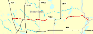
Minnesota State Highway 62 (east)
Encyclopedia
Highway
A highway is any public road. In American English, the term is common and almost always designates major roads. In British English, the term designates any road open to the public. Any interconnected set of highways can be variously referred to as a "highway system", a "highway network", or a...
in the Twin Cities region of Minnesota
Minnesota
Minnesota is a U.S. state located in the Midwestern United States. The twelfth largest state of the U.S., it is the twenty-first most populous, with 5.3 million residents. Minnesota was carved out of the eastern half of the Minnesota Territory and admitted to the Union as the thirty-second state...
. The route was part of Hennepin County
Hennepin County, Minnesota
Hennepin County is a county located in the U.S. state of Minnesota, named in honor of the 17th-century explorer Father Louis Hennepin. As of 2010 the population was 1,152,425. Its county seat is Minneapolis. It is by far the most populous county in Minnesota; more than one in five Minnesotans live...
Road 62 until 1988, when a portion of the route was inherited by the state. The western terminus of the route is at Interstate Highway 494
Interstate 494
Interstate 494 is a loop route making up part of a beltway of Interstate 94, circling through the southern and western portions of the Minneapolis – Saint Paul metropolitan area in Minnesota...
in Eden Prairie
Eden Prairie, Minnesota
As of the census of 2000, there were 54,901 people, 20,457 households, and 14,579 families residing in the city. The population density was . There were 21,026 housing units at an average density of 649.2 per square mile...
, where the roadway continues west as Hennepin County Road 62 to Hennepin County Road 101. The eastern terminus of the route is at State Highway 55
Minnesota State Highway 55
Minnesota State Highway 55 is a highway in west-central, central, and east-central Minnesota, which runs from the North Dakota state line near Tenney and continues east and southeast to its eastern terminus at its intersection with U.S...
near the Minneapolis-Saint Paul International Airport
Minneapolis-Saint Paul International Airport
Minneapolis-Saint Paul International Airport is the largest and busiest airport in the five-state upper Midwest region of Minnesota, Iowa, South Dakota, North Dakota, and Wisconsin.-Overview:...
in Minneapolis. Locally, the route is known as "the Crosstown," though there is no signage to reflect this on the roadway.http://www.dot.state.mn.us/metro/news/03/05/20hwy62.html Highway 62 is 12 miles (19.3 km) in length.
Route description
State Highway 62 serves as an east–west route between Eden Prairie, Minnetonka, Edina, Richfield, Minneapolis, and Fort Snelling. The route is constructed to freeway standards for most of its length, except for the western 1/2 mile, which is an expressway with two signal-controlled intersectionsIntersection (road)
An intersection is a road junction where two or more roads either meet or cross at grade . An intersection may be 3-way - a T junction or fork, 4-way - a crossroads, or 5-way or more...
. The route is located in Hennepin County
Hennepin County, Minnesota
Hennepin County is a county located in the U.S. state of Minnesota, named in honor of the 17th-century explorer Father Louis Hennepin. As of 2010 the population was 1,152,425. Its county seat is Minneapolis. It is by far the most populous county in Minnesota; more than one in five Minnesotans live...
.
Due to the existence of a second State Highway 62
Minnesota State Highway 62 (west)
Minnesota State Highway 62 is a highway in southwest Minnesota, which runs from its intersection with U.S. Highway 59 and Murray County Road 2 in Fulda and continues east to its eastern terminus at its intersection with U.S...
in the southwest corner of the state between Fulda
Fulda, Minnesota
As of the census of 2000, there were 1,283 people, 528 households, and 328 families residing in the city. The population density was 1,328.3 people per square mile . There were 568 housing units at an average density of 588.1 per square mile...
and Windom
Windom, Minnesota
As of the census of 2000, there were 4,490 people, 1,910 households, and 1,195 families residing in the city. The population density was 1,263.6 people per square mile . There were 2,089 housing units at an average density of 587.9 per square mile...
, the stretch of Highway 62 in the Twin Cities area starts its numbering at milepost 100. This is unorthodox in that the two state highways have a combined length of 36 miles (57.9 km). "Mile 100" is calibrated where Hennepin County Roads 101 and 62 meet at the Eden Prairie
Eden Prairie, Minnesota
As of the census of 2000, there were 54,901 people, 20,457 households, and 14,579 families residing in the city. The population density was . There were 21,026 housing units at an average density of 649.2 per square mile...
/ Minnetonka
Minnetonka, Minnesota
As of the census of 2000, there were 51,301 people, 21,393 households, and 14,097 families residing in the city. The population density was 1,893.0 persons per square mile . There were 22,228 housing units at an average density of 818.9 per square mile...
boundary line; though the mileposts themselves, starting with mile 104, do not appear until the state-maintained section inside the I-494
Interstate 494
Interstate 494 is a loop route making up part of a beltway of Interstate 94, circling through the southern and western portions of the Minneapolis – Saint Paul metropolitan area in Minnesota...
beltway.
History
State Highway 62 in the Twin Cities area was authorized in 1988. Prior to 1988, the route was designated as Hennepin County Road 62. The route was built mostly in the late 1960s by Hennepin County.The original Hennepin County numbering of 62 corresponded with 62nd Street in Minneapolis. However, some portions of Highway 62 do stray from the 62nd Street plane, as near the eastern terminus, Highway 62 runs along the plane of 58th Street.
Highway 62 previously had a traffic light
Traffic light
Traffic lights, which may also be known as stoplights, traffic lamps, traffic signals, signal lights, robots or semaphore, are signalling devices positioned at road intersections, pedestrian crossings and other locations to control competing flows of traffic...
at its eastern terminus at Highway 55 until an interchange
Interchange (road)
In the field of road transport, an interchange is a road junction that typically uses grade separation, and one or more ramps, to permit traffic on at least one highway to pass through the junction without directly crossing any other traffic stream. It differs from a standard intersection, at which...
was reconstructed during construction of the Hiawatha Line
Hiawatha Line
The Hiawatha Line is a light rail corridor in Hennepin County, Minnesota that extends from downtown Minneapolis to the southern suburb of Bloomington. It was formerly known as the Hiawatha Line named after Hiawatha Avenue. Major connections on the line include the Minneapolis-St...
light rail
Light rail
Light rail or light rail transit is a form of urban rail public transportation that generally has a lower capacity and lower speed than heavy rail and metro systems, but higher capacity and higher speed than traditional street-running tram systems...
in 2004.
I-35W and Highway 62 Crosstown Commons reconstruction project

Junction (traffic)
A junction, when discussed in the context of transport, is a location where traffic can change between different routes, directions, or sometimes modes, of travel.-Historical significance:...
in the region where it interweaves with Interstate Highway 35W
Interstate 35W (Minnesota)
Interstate 35W , is an Interstate Highway in the U.S. state of Minnesota, passing through downtown Minneapolis. It is one of two through routes for Interstate 35 through the Twin Cities of Minneapolis and Saint Paul, the other being Interstate 35E through downtown Saint Paul...
. This mile-long stretch is known as the Crosstown Commons, and the highway itself is known as the Crosstown Highway (but there is no signage on the roadway to reflect these names). Plans to "unweave" and expand this section of roadway to improve traffic flow have come and gone for many years, frustrating the 200,000 drivers who use it daily. Construction of the current design was expected to begin in July 2006, but was delayed due to failure on the part of the Pawlenty
Tim Pawlenty
Timothy James "Tim" Pawlenty , also known affectionately among supporters as T-Paw, is an American politician who served as the 39th Governor of Minnesota . He was a Republican candidate for President of the United States in the 2012 election from May to August 2011...
Administration to fund it. The project was adequately funded and bids were received in April 2007, and construction began in May 2007. The new interchange
Interchange (road)
In the field of road transport, an interchange is a road junction that typically uses grade separation, and one or more ramps, to permit traffic on at least one highway to pass through the junction without directly crossing any other traffic stream. It differs from a standard intersection, at which...
features three through-lanes for I-35W
Interstate 35W (Minnesota)
Interstate 35W , is an Interstate Highway in the U.S. state of Minnesota, passing through downtown Minneapolis. It is one of two through routes for Interstate 35 through the Twin Cities of Minneapolis and Saint Paul, the other being Interstate 35E through downtown Saint Paul...
(including one HOV
High-occupancy vehicle lane
In transportation engineering and transportation planning, a high-occupancy vehicle lane is a lane reserved for vehicles with a driver and one or more passengers...
lane) in each direction and two separate through-lanes for Highway 62 in each direction, eliminating the need to weave across traffic. The 2007 cost of correcting the deficiencies in that short stretch of highway was estimated to be $285 million.
The 2007 bid was won by the Ames, Lunda, and Schafer consortium for $288 million. The project included 25 new bridges, 63 lane-miles of highway, and expanded the total roadway width from 6 lanes to 12 lanes at Lyndale Avenue. The bridges were cast in Coates, Minnesota
Coates, Minnesota
Coates is a city in the U.S. state of Minnesota located west of the Upper Mississippi River on the exurban fringe in central Dakota County. U.S. Highway 52 connects north to Saint Paul while County Road 46 draws east-west to nearby suburban cities. The population was 161 at the 2010 census. It is...
and trucked in for on-site erection. The new design includes transit / HOV
High-occupancy vehicle lane
In transportation engineering and transportation planning, a high-occupancy vehicle lane is a lane reserved for vehicles with a driver and one or more passengers...
lanes and was completed in November 2010.