

Interstate 394
Encyclopedia
Interstate 394 is an east–west Interstate Highway spur route
in Hennepin County
in the U.S. state
of Minnesota
. It runs for 9.8 miles (15.8 km) from its eastern terminus in downtown Minneapolis to its western terminus at its junction
with Interstate 494
in the Minneapolis suburb of Minnetonka
. At its western terminus, the roadway loses its interstate designation but continues as U.S. Highway 12
. I-394 serves as the most direct link for commuters and other drivers who are traveling between downtown Minneapolis and parts of the western Minneapolis – Saint Paul metropolitan area.
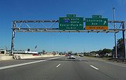
I-394 maintains at least three lanes in each direction except under the State Highway 100
interchange and also between Interstate 94
and its eastern terminus downtown.
with Interstate 494 (exit 19A/19B). From there, I-394 takes a 9.5 miles (15.3 km) course towards downtown Minneapolis where the eastern terminus is at 4th Street North.
Legally, the route of Interstate 394 is defined as unmarked legislative routes 10 and 107 in Minnesota Statutes §§ 161.114(2) and 161.115(38)., Interstate 394 is not marked with these legislative numbers along the actual highway.
es, motorcycle
s, and vehicles with two or more occupants to use them during rush hour
periods, while single-occupancy vehicles were not permitted. Now, drivers riding alone can use the lanes at any time, but must have a MnPASS
electronic toll collection
transponder in order to pay for using the express portions.
 From Interstate 494
to State Highway 100
, the lanes of I-394 are separated from traffic by double white lines. Between State Highway 100 and Interstate 94
near downtown, the two lanes are combined into a reversible expressway in the median
that is separated from the eastbound and westbound lanes by a concrete
barrier. This segment changes directions to accommodate the traffic flow at different times of day, so in the morning, it is open to downtown-bound eastward flowing traffic, while it is open to westbound traffic in the evening.
A MnPASS electronic transponder is required in order to pay toll
s because there are no tollbooth
s on the roadway. The price varies depending on the time of day and flow of traffic. Lone drivers were previously allowed to use the express lanes in off-peak times, but this is no longer allowed under the new system unless the sign says the cost is "OPEN," meaning free. The decision to make the non-reversible lanes free on off-hours was reached due to complaints about essentially making a four-lane freeway in an area that even on off-hours sorely needed six. Toll rates are expected to generally fall between $
1.00 and $4.00, with a potential maximum of $8.00. Off-hours are charged as $0.25 on the reversible lanes and free on the one-way lanes. The white line-separated and reversible expressway sections are priced separately. The lanes are still open free to buses, motorcycles, and cars with 2 or more persons, no matter the time of day, and such vehicles do not require transponders to use the lanes.
Using the express lanes as a lone driver without a transponder during charged periods, or crossing the double white lines will result in a large fine placed upon the driver. To enter and exit properly, vehicles must use an entry point without double white lines. The line rule is true even when the lane is free of charge.
Transponders began to be sold a few weeks before the May 16, 2005 opening date. By June 2005, about 6,500 drivers had signed up for the system.
freeway project in 1978. Interstate 335 had been planned to be a northern loop around downtown Minneapolis that would have passed through northeast Minneapolis. The money was substituted to the Interstate 394 project. Construction of Interstate 394 occurred mainly in the 1980s, starting at the western terminus in Minnetonka and opening in sections toward downtown Minneapolis throughout the late 1980s. The entire route of Interstate 394 was officially opened in 1991.
A former lane drop of I-394 at the Penn Avenue exit was eliminated in 2000.
Spur route
A spur route is a short road forming a branch from a longer, more important route . A bypass or beltway is never considered a true spur route as it typically reconnects with the major road...
in Hennepin County
Hennepin County, Minnesota
Hennepin County is a county located in the U.S. state of Minnesota, named in honor of the 17th-century explorer Father Louis Hennepin. As of 2010 the population was 1,152,425. Its county seat is Minneapolis. It is by far the most populous county in Minnesota; more than one in five Minnesotans live...
in the U.S. state
U.S. state
A U.S. state is any one of the 50 federated states of the United States of America that share sovereignty with the federal government. Because of this shared sovereignty, an American is a citizen both of the federal entity and of his or her state of domicile. Four states use the official title of...
of Minnesota
Minnesota
Minnesota is a U.S. state located in the Midwestern United States. The twelfth largest state of the U.S., it is the twenty-first most populous, with 5.3 million residents. Minnesota was carved out of the eastern half of the Minnesota Territory and admitted to the Union as the thirty-second state...
. It runs for 9.8 miles (15.8 km) from its eastern terminus in downtown Minneapolis to its western terminus at its junction
Junction (traffic)
A junction, when discussed in the context of transport, is a location where traffic can change between different routes, directions, or sometimes modes, of travel.-Historical significance:...
with Interstate 494
Interstate 494
Interstate 494 is a loop route making up part of a beltway of Interstate 94, circling through the southern and western portions of the Minneapolis – Saint Paul metropolitan area in Minnesota...
in the Minneapolis suburb of Minnetonka
Minnetonka, Minnesota
As of the census of 2000, there were 51,301 people, 21,393 households, and 14,097 families residing in the city. The population density was 1,893.0 persons per square mile . There were 22,228 housing units at an average density of 818.9 per square mile...
. At its western terminus, the roadway loses its interstate designation but continues as U.S. Highway 12
U.S. Route 12 in Minnesota
U.S. Route 12 is a highway in west-central and east-central Minnesota, which runs from the South Dakota state line at Ortonville near Big Stone Lake and continues east to the St. Croix River at the Wisconsin state line. U.S. 12 in Minnesota is in length...
. I-394 serves as the most direct link for commuters and other drivers who are traveling between downtown Minneapolis and parts of the western Minneapolis – Saint Paul metropolitan area.
I-394 maintains at least three lanes in each direction except under the State Highway 100
Minnesota State Highway 100
Minnesota State Highway 100 is a state highway in the Twin Cities region of Minnesota, which runs from its interchange with Interstate 494 in Bloomington and continues north to its northern terminus at its interchange with I-694 in Brooklyn Center...
interchange and also between Interstate 94
Interstate 94 in Minnesota
In the U.S. state of Minnesota, Interstate 94 runs east–west through the central portion of the state. The route connects the cities of Moorhead, Fergus Falls, Alexandria, St...
and its eastern terminus downtown.
Route description
Interstate 394 begins on the western side of the Twin Cities in the suburb of Minnetonka, at its interchangeInterchange (road)
In the field of road transport, an interchange is a road junction that typically uses grade separation, and one or more ramps, to permit traffic on at least one highway to pass through the junction without directly crossing any other traffic stream. It differs from a standard intersection, at which...
with Interstate 494 (exit 19A/19B). From there, I-394 takes a 9.5 miles (15.3 km) course towards downtown Minneapolis where the eastern terminus is at 4th Street North.
Legally, the route of Interstate 394 is defined as unmarked legislative routes 10 and 107 in Minnesota Statutes §§ 161.114(2) and 161.115(38)., Interstate 394 is not marked with these legislative numbers along the actual highway.
MnPASS toll lanes
There are two high-occupancy toll (HOT) express lanes at the center of the road. Prior to May 16, 2005, they had been traditional high-occupancy vehicle (HOV, or carpool) lanes, allowing busBus
A bus is a road vehicle designed to carry passengers. Buses can have a capacity as high as 300 passengers. The most common type of bus is the single-decker bus, with larger loads carried by double-decker buses and articulated buses, and smaller loads carried by midibuses and minibuses; coaches are...
es, motorcycle
Motorcycle
A motorcycle is a single-track, two-wheeled motor vehicle. Motorcycles vary considerably depending on the task for which they are designed, such as long distance travel, navigating congested urban traffic, cruising, sport and racing, or off-road conditions.Motorcycles are one of the most...
s, and vehicles with two or more occupants to use them during rush hour
Rush hour
A rush hour or peak hour is a part of the day during which traffic congestion on roads and crowding on public transport is at its highest. Normally, this happens twice a day—once in the morning and once in the evening, the times during when the most people commute...
periods, while single-occupancy vehicles were not permitted. Now, drivers riding alone can use the lanes at any time, but must have a MnPASS
MnPASS
MnPASS is an electronic toll collection system operated by the Minnesota Department of Transportation.The MnPASS transponder has a minimum first time charge of US$40, and there is a monthly fee of $1.50 to lease the transponder. Rush hour tolls for I-394 are usually between $1 and $4, though highly...
electronic toll collection
Electronic toll collection
Electronic toll collection , an adaptation of military "identification friend or foe" technology, aims to eliminate the delay on toll roads by collecting tolls electronically. It is thus a technological implementation of a road pricing concept...
transponder in order to pay for using the express portions.
Interstate 494
Interstate 494 is a loop route making up part of a beltway of Interstate 94, circling through the southern and western portions of the Minneapolis – Saint Paul metropolitan area in Minnesota...
to State Highway 100
Minnesota State Highway 100
Minnesota State Highway 100 is a state highway in the Twin Cities region of Minnesota, which runs from its interchange with Interstate 494 in Bloomington and continues north to its northern terminus at its interchange with I-694 in Brooklyn Center...
, the lanes of I-394 are separated from traffic by double white lines. Between State Highway 100 and Interstate 94
Interstate 94 in Minnesota
In the U.S. state of Minnesota, Interstate 94 runs east–west through the central portion of the state. The route connects the cities of Moorhead, Fergus Falls, Alexandria, St...
near downtown, the two lanes are combined into a reversible expressway in the median
Median
In probability theory and statistics, a median is described as the numerical value separating the higher half of a sample, a population, or a probability distribution, from the lower half. The median of a finite list of numbers can be found by arranging all the observations from lowest value to...
that is separated from the eastbound and westbound lanes by a concrete
Concrete
Concrete is a composite construction material, composed of cement and other cementitious materials such as fly ash and slag cement, aggregate , water and chemical admixtures.The word concrete comes from the Latin word...
barrier. This segment changes directions to accommodate the traffic flow at different times of day, so in the morning, it is open to downtown-bound eastward flowing traffic, while it is open to westbound traffic in the evening.
A MnPASS electronic transponder is required in order to pay toll
Electronic toll collection
Electronic toll collection , an adaptation of military "identification friend or foe" technology, aims to eliminate the delay on toll roads by collecting tolls electronically. It is thus a technological implementation of a road pricing concept...
s because there are no tollbooth
Toll road
A toll road is a privately or publicly built road for which a driver pays a toll for use. Structures for which tolls are charged include toll bridges and toll tunnels. Non-toll roads are financed using other sources of revenue, most typically fuel tax or general tax funds...
s on the roadway. The price varies depending on the time of day and flow of traffic. Lone drivers were previously allowed to use the express lanes in off-peak times, but this is no longer allowed under the new system unless the sign says the cost is "OPEN," meaning free. The decision to make the non-reversible lanes free on off-hours was reached due to complaints about essentially making a four-lane freeway in an area that even on off-hours sorely needed six. Toll rates are expected to generally fall between $
United States dollar
The United States dollar , also referred to as the American dollar, is the official currency of the United States of America. It is divided into 100 smaller units called cents or pennies....
1.00 and $4.00, with a potential maximum of $8.00. Off-hours are charged as $0.25 on the reversible lanes and free on the one-way lanes. The white line-separated and reversible expressway sections are priced separately. The lanes are still open free to buses, motorcycles, and cars with 2 or more persons, no matter the time of day, and such vehicles do not require transponders to use the lanes.
Using the express lanes as a lone driver without a transponder during charged periods, or crossing the double white lines will result in a large fine placed upon the driver. To enter and exit properly, vehicles must use an entry point without double white lines. The line rule is true even when the lane is free of charge.
Transponders began to be sold a few weeks before the May 16, 2005 opening date. By June 2005, about 6,500 drivers had signed up for the system.
History
The construction of Interstate 394 was authorized in 1968. Funding became available after the canceled Interstate 335Interstate 335 (Minnesota)
Interstate 335 is a cancelled auxiliary Interstate route in Minneapolis, Minnesota. It was planned to cross Northeast Minneapolis from I-35W south of Broadway to I-94 in North Minneapolis. Land was acquired and some demolition had proceeded when the road was defeated by local opposition.Interstate...
freeway project in 1978. Interstate 335 had been planned to be a northern loop around downtown Minneapolis that would have passed through northeast Minneapolis. The money was substituted to the Interstate 394 project. Construction of Interstate 394 occurred mainly in the 1980s, starting at the western terminus in Minnetonka and opening in sections toward downtown Minneapolis throughout the late 1980s. The entire route of Interstate 394 was officially opened in 1991.
A former lane drop of I-394 at the Penn Avenue exit was eliminated in 2000.