

Ramsey County, Minnesota
Encyclopedia
Ramsey County is a county located in the U.S. state
of Minnesota
, founded in 1849. As of 2010, the population was 508,640. Its county seat
is St. Paul, which is also Minnesota's state capital. The county is named for Alexander Ramsey
(W)
, the first governor of the Minnesota Territory
. It is one of the 11 counties in the Minneapolis – Saint Paul Metropolitan Area, and is the smallest and most densely populated county in Minnesota, as well as one of the most densely populated counties in the United States
.
since the 1990 United States Census.
of 2000, there were 511,035 people, 201,236 households, and 119,936 families residing in the county. The population density
was 3,281 people per square mile (1,267/km²). There were 206,448 housing units at an average density of 1,325 per square mile (512/km²). The racial makeup of the county was 77.37% White
, 7.61% Black
or African American
, 0.83% Native American
, 8.77% Asian
, 0.06% Pacific Islander
, 2.45% from other races
, and 2.90% from two or more races. 5.28% of the population were Hispanic
or Latino
of any race, according to the Census 2000.
 In terms of people who specified European ancestry
in the 2005-2007 American Community Survey
, the county was 31.2% German
, 14.3% Irish
, 11.3% Norwegian
, 9.5% Swedish
, 7.2% English
, and 5.9% French and/or French Canadian
. There is also a visible community of people of Sub-Saharan Africa
n ancestry, representing 2.9% of Ramsey County's population.
There were 201,236 households out of which 29.80% had children under the age of 18 living with them, 44.00% were married couples
living together, 11.90% had a female householder with no husband present, and 40.40% were non-families. 32.00% of all households were made up of individuals and 9.50% had someone living alone who was 65 years of age or older. The average household size was 2.45 and the average family size was 3.16.
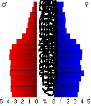
In the county the population was spread out with 25.60% under the age of 18, 11.30% from 18 to 24, 30.70% from 25 to 44, 20.70% from 45 to 64, and 11.60% who were 65 years of age or older. The median age was 34 years. For every 100 females there were 93.00 males. For every 100 females age 18 and over, there were 89.20 males.
The median income for a household in the county was $45,722, and the median income for a family was $57,747. (These figures had risen to $53,141 and $71,485, respectively, as of 2008.) Males had a median income of $39,806 versus $30,814 for females. The per capita income
for the county was $23,536. About 7.40% of families and 10.60% of the population were below the poverty line, including 15.70% of those under age 18 and 6.80% of those age 65 or over.

Commissioners as of November 2011
† Based in another county, but partially extending into Ramsey County.
‡ A small part of this city extends into Washington County
.
U.S. state
A U.S. state is any one of the 50 federated states of the United States of America that share sovereignty with the federal government. Because of this shared sovereignty, an American is a citizen both of the federal entity and of his or her state of domicile. Four states use the official title of...
of Minnesota
Minnesota
Minnesota is a U.S. state located in the Midwestern United States. The twelfth largest state of the U.S., it is the twenty-first most populous, with 5.3 million residents. Minnesota was carved out of the eastern half of the Minnesota Territory and admitted to the Union as the thirty-second state...
, founded in 1849. As of 2010, the population was 508,640. Its county seat
County seat
A county seat is an administrative center, or seat of government, for a county or civil parish. The term is primarily used in the United States....
is St. Paul, which is also Minnesota's state capital. The county is named for Alexander Ramsey
Alexander Ramsey
Alexander Ramsey was an American politician. He was born near Harrisburg, Pennsylvania.Alexander Ramsey was elected from Pennsylvania as a Whig to the U.S. House of Representatives and served in the 28th and 29th congresses from March 4, 1843 to March 4, 1847...
(W)
Whig Party (United States)
The Whig Party was a political party of the United States during the era of Jacksonian democracy. Considered integral to the Second Party System and operating from the early 1830s to the mid-1850s, the party was formed in opposition to the policies of President Andrew Jackson and his Democratic...
, the first governor of the Minnesota Territory
Minnesota Territory
The Territory of Minnesota was an organized incorporated territory of the United States that existed from March 3, 1849, until May 11, 1858, when the eastern portion of the territory was admitted to the Union as the State of Minnesota.-History:...
. It is one of the 11 counties in the Minneapolis – Saint Paul Metropolitan Area, and is the smallest and most densely populated county in Minnesota, as well as one of the most densely populated counties in the United States
United States
The United States of America is a federal constitutional republic comprising fifty states and a federal district...
.
Geography
According to the 2000 census, the county has a total area of 170.13 square miles (440.6 km²), of which 155.78 square miles (403.5 km²) (or 91.57%) is land and 14.36 square miles (37.2 km²) (or 8.44%) is water. It has been considered completely urbanizedUrbanization
Urbanization, urbanisation or urban drift is the physical growth of urban areas as a result of global change. The United Nations projected that half of the world's population would live in urban areas at the end of 2008....
since the 1990 United States Census.
Major highways
|
 Minnesota State Highway 51 Minnesota State Highway 51Minnesota State Highway 51 Minnesota State Highway 51 is a highway in Minnesota, which runs from its intersection with State Highway 5 in Saint Paul and continues north to its northern terminus at its interchange with Interstate 694 / U.S. Highway 10 in Arden Hills. The route is in length.Highway 51 is also known as...  Minnesota State Highway 96 Minnesota State Highway 96Minnesota State Highway 96 Minnesota State Highway 96 is a highway in Minnesota, which runs from its intersection with U.S. Highway 61 in White Bear Lake and continues east to its eastern terminus at its intersection with State Highway 95 on the northern edge of Stillwater....  Minnesota State Highway 120 Minnesota State Highway 120Minnesota State Highway 120 Minnesota State Highway 120 is a highway in Minnesota, which runs from its interchange with Interstate Highway 94 in Maplewood and continues north to its northern terminus at its intersection with State Highway 244 and Ramsey County Road 15 at the White Bear Lake / Mahtomedi boundary line...  Minnesota State Highway 149 Minnesota State Highway 149Minnesota State Highway 149 Minnesota State Highway 149 is a highway in Minnesota that runs from its intersection with State Highway 3 in Inver Grove Heights to its northern terminus at its intersection with State Highway 5 in Saint Paul. The route is in length....  Minnesota State Highway 156 Minnesota State Highway 156Minnesota State Highway 156 Minnesota State Highway 156 is a highway in Minnesota, which runs from its interchange with Interstate 494 in South St. Paul and continues north to its northern terminus at its interchange with U.S. Highway 52 near downtown Saint Paul....  Minnesota State Highway 280 Minnesota State Highway 280Minnesota State Highway 280 Minnesota State Highway 280 is a highway in the Twin Cities region of Minnesota, which runs from its interchange with Interstate 94 in Saint Paul and continues north to its interchange with Interstate 35W in Roseville...  County 49 (Rice Street/Hodgson Road) County 49 (Rice Street/Hodgson Road) County 51 (Lexington Avenue) County 51 (Lexington Avenue) County 65 (White Bear Avenue) County 65 (White Bear Avenue) |
.svg.png)
.svg.png)
.svg.png)
.svg.png)


Adjacent counties
- Anoka CountyAnoka County, MinnesotaAnoka County is the fourth-most populous county in the U.S. state of Minnesota. The county is bordered by the counties of Isanti on the north, Chisago and Washington on the east, Hennepin and Ramsey on the south, Sherburne on the west, and the Mississippi River on the southwest.As of 2010, Anoka...
(north) - Washington CountyWashington County, MinnesotaWashington County is a county established in 1849 in the U.S. state of Minnesota. As of 2010, the population was 238,136. Its county seat is Stillwater.-History:...
(east) - Dakota CountyDakota County, MinnesotaDakota County is the third most populous county in the U.S. state of Minnesota. The county is bordered by the Minnesota and Mississippi Rivers on the north, and the state of Wisconsin on the east. Dakota County comprises the southeast portion of seven-county Minneapolis-St. Paul, the thirteenth...
(south) - Hennepin CountyHennepin County, MinnesotaHennepin County is a county located in the U.S. state of Minnesota, named in honor of the 17th-century explorer Father Louis Hennepin. As of 2010 the population was 1,152,425. Its county seat is Minneapolis. It is by far the most populous county in Minnesota; more than one in five Minnesotans live...
(west)
Demographics
As of the censusCensus
A census is the procedure of systematically acquiring and recording information about the members of a given population. It is a regularly occurring and official count of a particular population. The term is used mostly in connection with national population and housing censuses; other common...
of 2000, there were 511,035 people, 201,236 households, and 119,936 families residing in the county. The population density
Population density
Population density is a measurement of population per unit area or unit volume. It is frequently applied to living organisms, and particularly to humans...
was 3,281 people per square mile (1,267/km²). There were 206,448 housing units at an average density of 1,325 per square mile (512/km²). The racial makeup of the county was 77.37% White
Race (United States Census)
Race and ethnicity in the United States Census, as defined by the Federal Office of Management and Budget and the United States Census Bureau, are self-identification data items in which residents choose the race or races with which they most closely identify, and indicate whether or not they are...
, 7.61% Black
Race (United States Census)
Race and ethnicity in the United States Census, as defined by the Federal Office of Management and Budget and the United States Census Bureau, are self-identification data items in which residents choose the race or races with which they most closely identify, and indicate whether or not they are...
or African American
Race (United States Census)
Race and ethnicity in the United States Census, as defined by the Federal Office of Management and Budget and the United States Census Bureau, are self-identification data items in which residents choose the race or races with which they most closely identify, and indicate whether or not they are...
, 0.83% Native American
Race (United States Census)
Race and ethnicity in the United States Census, as defined by the Federal Office of Management and Budget and the United States Census Bureau, are self-identification data items in which residents choose the race or races with which they most closely identify, and indicate whether or not they are...
, 8.77% Asian
Race (United States Census)
Race and ethnicity in the United States Census, as defined by the Federal Office of Management and Budget and the United States Census Bureau, are self-identification data items in which residents choose the race or races with which they most closely identify, and indicate whether or not they are...
, 0.06% Pacific Islander
Race (United States Census)
Race and ethnicity in the United States Census, as defined by the Federal Office of Management and Budget and the United States Census Bureau, are self-identification data items in which residents choose the race or races with which they most closely identify, and indicate whether or not they are...
, 2.45% from other races
Race (United States Census)
Race and ethnicity in the United States Census, as defined by the Federal Office of Management and Budget and the United States Census Bureau, are self-identification data items in which residents choose the race or races with which they most closely identify, and indicate whether or not they are...
, and 2.90% from two or more races. 5.28% of the population were Hispanic
Race (United States Census)
Race and ethnicity in the United States Census, as defined by the Federal Office of Management and Budget and the United States Census Bureau, are self-identification data items in which residents choose the race or races with which they most closely identify, and indicate whether or not they are...
or Latino
Race (United States Census)
Race and ethnicity in the United States Census, as defined by the Federal Office of Management and Budget and the United States Census Bureau, are self-identification data items in which residents choose the race or races with which they most closely identify, and indicate whether or not they are...
of any race, according to the Census 2000.
European American
A European American is a citizen or resident of the United States who has origins in any of the original peoples of Europe...
in the 2005-2007 American Community Survey
American Community Survey
The American Community Survey is an ongoing statistical survey by the U.S. Census Bureau, sent to approximately 250,000 addresses monthly . It regularly gathers information previously contained only in the long form of the decennial census...
, the county was 31.2% German
German American
German Americans are citizens of the United States of German ancestry and comprise about 51 million people, or 17% of the U.S. population, the country's largest self-reported ancestral group...
, 14.3% Irish
Irish American
Irish Americans are citizens of the United States who can trace their ancestry to Ireland. A total of 36,278,332 Americans—estimated at 11.9% of the total population—reported Irish ancestry in the 2008 American Community Survey conducted by the U.S. Census Bureau...
, 11.3% Norwegian
Norwegian American
Norwegian Americans are Americans of Norwegian descent. Norwegian immigrants went to the United States primarily in the later half of the 19th century and the first few decades of the 20th century. There are more than 4.5 million Norwegian Americans according to the most recent U.S. census, and...
, 9.5% Swedish
Swedish American
Swedish Americans are Americans of Swedish descent, especially the descendants of about 1.2 million immigrants from Sweden during 1885-1915. Most were Lutherans who affiliated with the Evangelical Lutheran Church in America ; some were Methodists...
, 7.2% English
English American
English Americans are citizens or residents of the United States whose ancestry originates wholly or partly in England....
, and 5.9% French and/or French Canadian
French American
French Americans or Franco-Americans are Americans of French or French Canadian descent. About 11.8 million U.S. residents are of this descent, and about 1.6 million speak French at home.An additional 450,000 U.S...
. There is also a visible community of people of Sub-Saharan Africa
Sub-Saharan Africa
Sub-Saharan Africa as a geographical term refers to the area of the African continent which lies south of the Sahara. A political definition of Sub-Saharan Africa, instead, covers all African countries which are fully or partially located south of the Sahara...
n ancestry, representing 2.9% of Ramsey County's population.
There were 201,236 households out of which 29.80% had children under the age of 18 living with them, 44.00% were married couples
Marriage
Marriage is a social union or legal contract between people that creates kinship. It is an institution in which interpersonal relationships, usually intimate and sexual, are acknowledged in a variety of ways, depending on the culture or subculture in which it is found...
living together, 11.90% had a female householder with no husband present, and 40.40% were non-families. 32.00% of all households were made up of individuals and 9.50% had someone living alone who was 65 years of age or older. The average household size was 2.45 and the average family size was 3.16.
In the county the population was spread out with 25.60% under the age of 18, 11.30% from 18 to 24, 30.70% from 25 to 44, 20.70% from 45 to 64, and 11.60% who were 65 years of age or older. The median age was 34 years. For every 100 females there were 93.00 males. For every 100 females age 18 and over, there were 89.20 males.
The median income for a household in the county was $45,722, and the median income for a family was $57,747. (These figures had risen to $53,141 and $71,485, respectively, as of 2008.) Males had a median income of $39,806 versus $30,814 for females. The per capita income
Per capita income
Per capita income or income per person is a measure of mean income within an economic aggregate, such as a country or city. It is calculated by taking a measure of all sources of income in the aggregate and dividing it by the total population...
for the county was $23,536. About 7.40% of families and 10.60% of the population were below the poverty line, including 15.70% of those under age 18 and 6.80% of those age 65 or over.
County Commissioners
The county commission elects a chair who presides at meetings.Commissioners as of November 2011
| District | Commissioner | In office since | Current term expires in January |
|---|---|---|---|
| 1st | Tony Bennett | 1997 | 2013 |
| 2nd | Jan Parker | 1997 | 2013 |
| 3rd | Janice Rettman | 1997 | 2013 |
| 4th | Toni Carter | 2005 | 2013 |
| 5th | Rafael Ortega | 1995 | 2013 |
| 6th | Jim McDonough | ? | 2013 |
| 7th | Victoria Reinhardt (Chair) | 1997 | 2013 |
Cities and towns
| Cities | Townships | |
|---|---|---|
|
North Oaks, Minnesota North Oaks is a suburb north of Saint Paul in Ramsey County in the U.S. state of Minnesota. The population was 4,469 at the 2010 census.Formerly a gated community that now posts private access signage, all land is owned by homeowners with the North Oaks Home Owners Association maintaining all... North St. Paul, Minnesota North St. Paul is a city in Ramsey County, Minnesota, east of the city of Saint Paul. The population was 11,460 at the 2010 census.North St. Paul is a distinct city, and not a neighborhood of nearby St. Paul... Roseville, Minnesota As of the census of 2000, there were 33,690 people, 14,598 households, and 8,598 families residing in the city. The population density was 2,543.9 people per square mile . There were 14,917 housing units at an average density of 1,126.4 per square mile... Shoreview, Minnesota As of the census of 2000, there are 25,377 people, Males: 12,303 , Females: 13,074 , 9,965 households, and 7,021 families residing in the city. The population density is 2,315.9 people per square mile . There are 10,127 housing units at an average density of 919.2 per square mile... Spring Lake Park, Minnesota Spring Lake Park is a city in Anoka and Ramsey counties in the U.S. state of Minnesota. The population was 6,412 at the 2010 census. The city lies mainly in Anoka County.... † Vadnais Heights, Minnesota Vadnais Heights is a city in Ramsey County, Minnesota, United States. The population was 12,302 at the 2010 census.-Geography:According to the United States Census Bureau, the city has a total area of , of which, is land and is water. It borders the cities of Shoreview, Little Canada, White Bear... White Bear Lake, Minnesota White Bear Lake is a city in Ramsey and Washington counties in the U.S. state of Minnesota. The population was 23,797 at the 2010 census. The city is located on White Bear Lake, one of the largest lakes in the Minneapolis-St... ‡ |
|
† Based in another county, but partially extending into Ramsey County.
‡ A small part of this city extends into Washington County
Washington County, Minnesota
Washington County is a county established in 1849 in the U.S. state of Minnesota. As of 2010, the population was 238,136. Its county seat is Stillwater.-History:...
.
See also
- Ramsey County LibraryRamsey County LibraryRamsey County Library is a library system that operates in suburban Ramsey County, Minnesota. The system has seven branches. The library started in the 1920s when the extension division of the Saint Paul Public Library provided books for various public schools in the county outside of Saint Paul....
- National Register of Historic Places listings in Ramsey County, Minnesota
- Ramsey County Sheriff Matt BostromMatt BostromMatthew D. "Matt" Bostrom is currently Sheriff of Ramsey County, a totally urban county encompassing Saint Paul, the state capital city of Minnesota. Bostrom was elected Sheriff in 2010 by winning over four-term incumbent Bob Fletcher by a 14% margin. In an earlier role as St...