
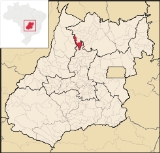
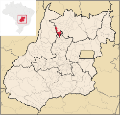
Santa Terezinha de Goiás
Encyclopedia
| Santa Terezinha de Goiás | |
|---|---|
| State | Goiás Goiás Goiás is a state of Brazil, located in the central part of the country. The name Goiás comes from the name of an indigenous community... |
| Area: | 1,202.2 km² |
| Population: | 11,558 (IBGE 2007) |
| Elevation: | 409m above sea level |
| Postcode (CEP): | 76500-000 |
| IBGE statistical microregion: | 004 Porangatu Microregion Porangatu Microregion The Porangatu Microregion is a statistical region created by IBGE in north-central Goiás state, Brazil. The most important city is Porangatu... |
| Became a city: | 1963 |
| Distance to Goiânia Goiânia -Climate:The city has a tropical wet and dry climate with an average temperature of . There's a wet season, from October to April, and a dry one, from May to September. Annual rainfall is around 1,520 mm.... : |
300 km. |
| Website: | none |
City
A city is a relatively large and permanent settlement. Although there is no agreement on how a city is distinguished from a town within general English language meanings, many cities have a particular administrative, legal, or historical status based on local law.For example, in the U.S...
and municipality
Municipality
A municipality is essentially an urban administrative division having corporate status and usually powers of self-government. It can also be used to mean the governing body of a municipality. A municipality is a general-purpose administrative subdivision, as opposed to a special-purpose district...
in north Goiás
Goiás
Goiás is a state of Brazil, located in the central part of the country. The name Goiás comes from the name of an indigenous community...
state, Brazil
Brazil
Brazil , officially the Federative Republic of Brazil , is the largest country in South America. It is the world's fifth largest country, both by geographical area and by population with over 192 million people...
. Santa Terezinha is sometimes written as ""Santa Teresinha".
Location
Santa Terezinha is in the extreme north of the state, 174 km. southwest of PorangatuPorangatu
Parangatu is a town in Goiás state, Brazil-Geography:Parangatu is in its own microregion, Porangatu Microregion, of 226,766 inhabitants in an area of 35.287 km²; 426 km from the state capital, Goiânia. This microregion serves as a nucleus for eighteen municipalities in the north of Goiás state...
. It is 66 km. west of the important BR-153 highway.
Highway connections from Goiânia
Goiânia
-Climate:The city has a tropical wet and dry climate with an average temperature of . There's a wet season, from October to April, and a dry one, from May to September. Annual rainfall is around 1,520 mm....
are made by GO-080 / Nerópolis
Nerópolis
Nerópolis is a small city and municipality in central Goiás state, Brazil.-Location:The municipality is part of the metropolitan region of Goiânia, which is 42 kilometers to the west. It is nationally known as the city of garlic and sweets...
/ São Francisco de Goiás
São Francisco de Goiás
São Francisco de Goiás is a small town and municipality in central Goiás state, Brazil.Municipal boundaries:*North: Jaraguá*South: Petrolina de Goiás*East: Pirenópolis*West: Jesúpolis and Jaraguá...
/ BR-153 / Jaraguá / Rianápolis
Rianápolis
Rianápolis is a small town and municipality in northeastern Goiás state, Brazil.-Location:It is located almost directly north of the state capital and is on the important BR-153 highway, which links Belem to São Paulo. The regional center of Ceres is located 19 km. to the northwest. Highway...
/ Rialma
Rialma
Rialma is a small city and municipality in north-central Goiás state, Brazil.-Location and Geography:Rialma is located across the Rio das Almas from Ceres on the important interstate highway BR-153, which links Anápolis to Belém. It was created as part of the urban area of Ceres, which was also...
/ GO-336 / Itapaci
Itapaci
Itapaci is a small town and municipality in northern Goiás state, Brazil. The population was 16,003 in 2007 . The total area of the municipality was 956.1 km² .-Geography:...
/ GO-154 / Pilar de Goiás
Pilar de Goiás
Pilar de Goiás is a small town and municipality in north-central Goiás state, Brazil.-Location:Pilar is located 252 kilometers north of the state capital, Goiânia in the Ceres Microregion. It is connected to the south of the state, with its main urban centers, by highway BR-153...
.
Santa Terezinha de Goiás is bordered by the following municipalities:
- north: Campos Verdes de Goiás and Mara RosaMara RosaMara Rosa is a small town and municipality in north-central Goiás state, Brazil.-Location:Mara Rosa is located 356 kilometers north of Goiânia in the Porangatu Microregion. It is 11 kilometers east of the Belém-Brasília highway, between the basins of the Araguaia River and the Tocantins River...
- south: GuarinosGuarinosGuarinos is a small town and municipality in northern Goiás state, Brazil. The population was 2,411 in a total area of 595.8 km² .-Highway Connections:...
- east: UruaçuUruaçuUruaçu is a small city and municipality in north Goiás state, Brazil.-Geography:Uruaçu is located north of Anápolis and Goiânia on the important interstate highway BR-153, which links Brasília to Belém. It is 269 km. from Goiânia and 244 km. from Brasília...
- west: CrixásCrixásCrixás is a small city and municipality in northwestern Goiás state, Brazil. The population was 14,547 in a total area of 4,661.5 km². Crixás was a major gold producing area but is now gradually losing population....
Political Information
- Mayor: Vitalino da Silva Muniz (January 2005)
- City council: 09
- Eligible voters: 8,998 (December/2007)
Demographics
- Population density: 9.61 inhab/km² (2007)
- Urban population: 8,673 (2007)
- Rural population: 2,885 (2007)
- Population change: 1.37% 1996/2007
The economy
The economy is based on modest agriculture, cattle raising, services, public administration, and small transformation industries.- Industrial units: 18 (2007)
- Retail units: 111 (2007), employing 275 workers in 2005
- Financial institutions: Banco do Brasil S.A. - BRADESCO S.A. (01/06/2005)
- Automobiles: 567 (2007)
Agricultural Data (2006)
- Farms: 691
- Total agricultural Area: 66,678 hectares
- Permanent Planted Area: 2,297 hectares
- Temporary Planted Area: 3,441 hectares
- Natural Pasture: 43,488 hectares
- Woodland and Forest: 15,177 hectares
- Workers related to the farm owner: 1,609
- Workers not related to the farm owner: 188 (IBGE)
- Cattle herd: 77,000 head (2006)
- Main crops: rice (280 hectares), bananas, beans, manioc, corn (900 hectares), palm hearts and coconut.
Education (2006)
- Schools: 11 with 3,503 students
- Higher education: campus of the Universidade Estadual de Goiás
- Adult literacy rate: 83.0% (2000) (national average was 86.4%)
Health (2007)
- Hospitals: 1
- Hospital beds: 43
- Ambulatory clinics: 5
- Infant mortality rate: 27.56 (2000) (national average was 33.
Municipal Human Development Index
Human Development Index
The Human Development Index is a composite statistic used to rank countries by level of "human development" and separate "very high human development", "high human development", "medium human development", and "low human development" countries...
- MHDI: 0.721
- State ranking: 171 (out of 242 municipalities in 2000)
- National ranking: 2,607 (out of 5,507 municipalities in 2000)
Seplan Economic Development Index
The ranking was 168 out of 246 municipalities. See Seplan
Seplan Social Development Index
The ranking was 101 out of 246 municipalities. See Seplan