
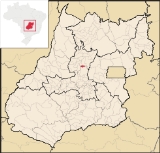
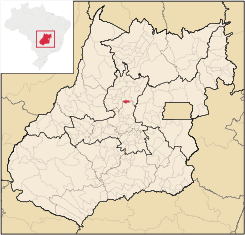
Rianápolis
Encyclopedia
| Rianápolis | |
|---|---|
| State | Goiás Goiás Goiás is a state of Brazil, located in the central part of the country. The name Goiás comes from the name of an indigenous community... |
| Area: | 159.3 km² |
| Population: | 4,167 (IBGE 2007) |
| Elevation: | 589 m above sea level |
| Postcode (CEP): | 76310-000 |
| Became a city: | 1958 |
| Mayor: | Ery de Castro e Silva |
| Distance to Goiânia Goiânia -Climate:The city has a tropical wet and dry climate with an average temperature of . There's a wet season, from October to April, and a dry one, from May to September. Annual rainfall is around 1,520 mm.... : |
156 km |
| Statistical Microregion: | Ceres Microregion Ceres Microregion The Ceres Microregion is located in north-central Goiás state, Brazil. It includes 22 cities with a total population of 215,820 inhabitants . The total area is 13,224.40 km² and the population density is 16.32 inhab/km². The most important cities are Ceres and Goianésia.The most populous... |
| Website: | not available |
Town
A town is a human settlement larger than a village but smaller than a city. The size a settlement must be in order to be called a "town" varies considerably in different parts of the world, so that, for example, many American "small towns" seem to British people to be no more than villages, while...
and municipality
Municipality
A municipality is essentially an urban administrative division having corporate status and usually powers of self-government. It can also be used to mean the governing body of a municipality. A municipality is a general-purpose administrative subdivision, as opposed to a special-purpose district...
in northeastern Goiás
Goiás
Goiás is a state of Brazil, located in the central part of the country. The name Goiás comes from the name of an indigenous community...
state, Brazil
Brazil
Brazil , officially the Federative Republic of Brazil , is the largest country in South America. It is the world's fifth largest country, both by geographical area and by population with over 192 million people...
.
Location
It is located almost directly north of the state capital and is on the important BR-153 highway, which links BelemBelem
Belem or Belém may refer to:* Belém, capital city of the Brazilian state of Pará* Belem , a three-masted barque from France* Belém, Alagoas, a municipality located in the Brazilian state of Alagoas...
to São Paulo
São Paulo
São Paulo is the largest city in Brazil, the largest city in the southern hemisphere and South America, and the world's seventh largest city by population. The metropolis is anchor to the São Paulo metropolitan area, ranked as the second-most populous metropolitan area in the Americas and among...
. The regional center of Ceres
Ceres, Goiás
Ceres is a small city and municipality in central Goiás state, Brazil. It was the first agricultural colony built in the state of Goiás.-Geography:...
is located 19 km. to the northwest. Highway connections from Goiânia are made by taking BR-153 from Anápolis
Anápolis
Anápolis is the third largest city in the State of Goiás in Brazil. It lies in the center of a rich agricultural region and has become a leader in food processing and pharmaceutical plants.-Location and population:...
to Rianápolis. From Goiânia
Goiânia
-Climate:The city has a tropical wet and dry climate with an average temperature of . There's a wet season, from October to April, and a dry one, from May to September. Annual rainfall is around 1,520 mm....
take GO-080 / Nerópolis
Nerópolis
Nerópolis is a small city and municipality in central Goiás state, Brazil.-Location:The municipality is part of the metropolitan region of Goiânia, which is 42 kilometers to the west. It is nationally known as the city of garlic and sweets...
/ São Francisco de Goiás
São Francisco de Goiás
São Francisco de Goiás is a small town and municipality in central Goiás state, Brazil.Municipal boundaries:*North: Jaraguá*South: Petrolina de Goiás*East: Pirenópolis*West: Jesúpolis and Jaraguá...
/ BR-153 / Jaraguá. Rianápolis is 43 km. north of Jaraguá. See Seplan
- Neighboring municipalities: RialmaRialmaRialma is a small city and municipality in north-central Goiás state, Brazil.-Location and Geography:Rialma is located across the Rio das Almas from Ceres on the important interstate highway BR-153, which links Anápolis to Belém. It was created as part of the urban area of Ceres, which was also...
, Santa Rita do Novo DestinoSanta Rita do Novo DestinoSanta Rita do Novo Destino is a small town and municipality in northeastern Goiás state, Brazil.-Location:Santa Rita do Novo Destino is 82 km. east of Ceres and 15 km. north of Goianésia. Highway connections from Goiânia are made by taking GO-080 / Nerópolis / São Francisco de Goiás / BR-153 /...
, Jaraguá, and UruanaUruanaUruana is a small city and municipality in central Goiás state, Brazil. It is known statewide as the watermelon capital of the state.-Location:...
Demographics
- Urban population: 3,657
- Population density: 26.15 inhab/km² (2007)
- Population growth: -0.61% 1996/2007
The Economy
Economic activity is based on agriculture, cattle raising, services, small transformation industries, and government employment. There were 135 farms in 2006 with a total of 4,724 hectares. Pasture land made up 90 percent of the total. The cattle herd had 15,000 head in 2006 while the main agricultural crops were rice, sugarcane, beans, manioc, corn, and soybeans.Health and Education
There were 4 schools in 2006. The adult literacy rate was 83.7% (2000) (the national average was 86.4%). There was 1 hospital with 43 beds. The infant mortality rate was 17.5 (2000) (the national average was 33.0).Municicipal Human Development Index
Human Development Index
The Human Development Index is a composite statistic used to rank countries by level of "human development" and separate "very high human development", "high human development", "medium human development", and "low human development" countries...
: 0.759
For the complete list see frigoletto.com.br
History
The settlement began in the early 1940's along the road linking Jaraguá to the Colônia Nacional Agrícola de Goiás, present-day CeresCeres, Goiás
Ceres is a small city and municipality in central Goiás state, Brazil. It was the first agricultural colony built in the state of Goiás.-Geography:...
near an airstrip. The first houses served as a resting place for travellers between the two towns. Soon there was a store and a small hotel. The settlement was first called "Campo de Aviação", after the landing strip. In 1958 it became a municipality taking the name of Rianápols, because of its location between the towns of Rialma
Rialma
Rialma is a small city and municipality in north-central Goiás state, Brazil.-Location and Geography:Rialma is located across the Rio das Almas from Ceres on the important interstate highway BR-153, which links Anápolis to Belém. It was created as part of the urban area of Ceres, which was also...
and Anápolis