
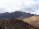
Grisedale Pike
Encyclopedia

Fell
“Fell” is a word used to refer to mountains, or certain types of mountainous landscape, in Scandinavia, the Isle of Man, and parts of northern England.- Etymology :...
in the Lake District
Lake District
The Lake District, also commonly known as The Lakes or Lakeland, is a mountainous region in North West England. A popular holiday destination, it is famous not only for its lakes and its mountains but also for its associations with the early 19th century poetry and writings of William Wordsworth...
, Cumbria
Cumbria
Cumbria , is a non-metropolitan county in North West England. The county and Cumbria County Council, its local authority, came into existence in 1974 after the passage of the Local Government Act 1972. Cumbria's largest settlement and county town is Carlisle. It consists of six districts, and in...
, England
England
England is a country that is part of the United Kingdom. It shares land borders with Scotland to the north and Wales to the west; the Irish Sea is to the north west, the Celtic Sea to the south west, with the North Sea to the east and the English Channel to the south separating it from continental...
situated 4.5 miles (7.2 km) west of the town of Keswick
Keswick, Cumbria
Keswick is a market town and civil parish within the Borough of Allerdale in Cumbria, England. It had a population of 4,984, according to the 2001 census, and is situated just north of Derwent Water, and a short distance from Bassenthwaite Lake, both in the Lake District National Park...
in the north-western sector
North Western Fells
The North Western Fells are a group of hills in the English Lake District. Including such favourites as Catbells and Grisedale Pike, they occupy an oval area beneath the Buttermere and Borrowdale valley systems...
of the national park
Lake District National Park
The Lake District National Park is located in the north-west of England and is the largest of the English National Parks and the second largest in the United Kingdom. It is in the central and most-visited part of the Lake District....
. At a height of 791 m (2593 feet) it is the 40th highest Wainwright in the Lake District; it also qualifies as a Hewitt, Marilyn
Marilyn (hill)
A Marilyn is a mountain or hill in the United Kingdom, Republic of Ireland or Isle of Man with a relative height of at least 150 metres , regardless of absolute height or other merit...
and Nuttall. Grisedale Pike presents a striking appearance when viewed from the east, rising to a perfect pyramidal peak and has the nickname of “The Matterhorn
Matterhorn
The Matterhorn , Monte Cervino or Mont Cervin , is a mountain in the Pennine Alps on the border between Switzerland and Italy. Its summit is 4,478 metres high, making it one of the highest peaks in the Alps. The four steep faces, rising above the surrounding glaciers, face the four compass points...
of Lakeland”. It possesses two subsidiary summits: Hobcarton Crag and Hobcarton End.
Topography
Grisedale Pike is a large fell throwing down three long ridges to the valley floors and two shorter ones that link to the adjoining fell of Hopegill HeadHopegill Head
Hopegill Head is a fell in the English Lake District in Cumbria. It is located nine kilometres west of the town of Keswick and is well seen from the B5292 road which crosses the Whinlatter Pass.-Topography:...
and the strategically important Coledale Hause which links the fell to the rest of the Coledale Fells. It is bounded to the south by the four kilometre valley of Coledale and to the north by the Whinlatter Pass
Whinlatter Pass
The Whinlatter Pass is a mountain pass in the English Lake District. It is located on the B5292 road linking Braithwaite, to the west of Keswick, with High Lorton to the south of Cockermouth....
which carries the B5292 motor road. The village of Braithwaite
Braithwaite
Braithwaite is a village in the northern Lake District, in Cumbria, England. Historically within Cumberland, it lies just to the west of Keswick and to the east of the Grisedale Pike ridge, in the Borough of Allerdale. It forms part of the civil parish of Above Derwent.The eastern end of the...
sits at the foot of the long eastern ridge, and some of the northern slopes have been planted by the Forestry Commission
Forestry Commission
The Forestry Commission is a non-ministerial government department responsible for forestry in Great Britain. Its mission is to protect and expand Britain's forests and woodlands and increase their value to society and the environment....
, with the Hospital Plantation occupying much of the valley of Grisedale.
Geology and Mining
The ridge is composed of the laminated mudstoneMudstone
Mudstone is a fine grained sedimentary rock whose original constituents were clays or muds. Grain size is up to 0.0625 mm with individual grains too small to be distinguished without a microscope. With increased pressure over time the platey clay minerals may become aligned, with the...
and siltstone
Siltstone
Siltstone is a sedimentary rock which has a grain size in the silt range, finer than sandstone and coarser than claystones.- Description :As its name implies, it is primarily composed of silt sized particles, defined as grains 1/16 - 1/256 mm or 4 to 8 on the Krumbein phi scale...
of the Kirkstile Formation, typical of the Skiddaw
Skiddaw
Skiddaw is a mountain in the Lake District National Park in England. With a summit at 931 m above sea level it is the fourth highest mountain in England. It lies just north of the town of Keswick, Cumbria, and dominates the skyline in this part of the northern lakes...
group.
The Coledale
Coledale (Cumbria)
In Cumbria, England, Coledale is a valley in the northwestern region of the Lake District ~-Geography:Coledale is a narrow V shaped river valley running approximately north-east towards the Derwent Valley floodplain and the village of Braithwaite at the northeastern end...
side of the fell has been extensively mined, with the Force Crag mine being the last working lead
Lead
Lead is a main-group element in the carbon group with the symbol Pb and atomic number 82. Lead is a soft, malleable poor metal. It is also counted as one of the heavy metals. Metallic lead has a bluish-white color after being freshly cut, but it soon tarnishes to a dull grayish color when exposed...
mine in the Lake District before closing in 1990; it also produced zinc
Zinc
Zinc , or spelter , is a metallic chemical element; it has the symbol Zn and atomic number 30. It is the first element in group 12 of the periodic table. Zinc is, in some respects, chemically similar to magnesium, because its ion is of similar size and its only common oxidation state is +2...
and barite
Barite
Baryte, or barite, is a mineral consisting of barium sulfate. The baryte group consists of baryte, celestine, anglesite and anhydrite. Baryte itself is generally white or colorless, and is the main source of barium...
. The mine has had many owners and been closed and reopened regularly since the early nineteenth century. The mine suffered a major collapse in 1990 which led to the owners, the New Coledale Mining Company, deciding to close it.
Ascents
The majority of ascents of Grisedale Pike usually start at the village of Braithwaite using a well blazed trail up the eastern ridge. An alternative ascent starts at a car park in Hospital Plantation near the top of the Whinlatter Pass and goes up the northern ridge taking in the “Nuttall” top of Hobcarton End before continuing to the summit. From the same starting point it is possible to climb the fell up the north eastern ridge following a ruined dry stone wall.Grisedale Pike is often included in the circular walk called the Coledale Round, a 17.5 kilometre walk starting and finishing at Braithwaite. It includes the other fells of Hopegill Head
Hopegill Head
Hopegill Head is a fell in the English Lake District in Cumbria. It is located nine kilometres west of the town of Keswick and is well seen from the B5292 road which crosses the Whinlatter Pass.-Topography:...
, Eel Crag, Sail
Sail (Lake District)
Sail is a hill in the English Lake District, lying between Derwentwater and Crummock Water.-Topography:The North Western Fells occupy the area between the rivers Derwent and Cocker, a broadly oval swathe of hilly country, elongated on a north-south axis. Two roads cross from east to west, dividing...
, Scar Crags
Scar Crags
Scar Crags is a fell in the north western part of the English Lake District in the county of Cumbria. It is one of the Coledale group of fells situated seven kilometres south west of Keswick and reaches a height of 672 metres .-Topography:...
and Causey Pike
Causey Pike
Causey Pike is a fell in the English Lake District. It is situated in the Newlands Valley, 5 km south west of the town of Keswick. Even though it has a modest height of 637 metres it is one of the most distinctive fells when viewed from the Derwent Water and Keswick area due to its...
with over 1300 metres of ascent. The view from the top of the fell is comprehensive with the Cumbrian coast in view to the west and the Pennines
Pennines
The Pennines are a low-rising mountain range, separating the North West of England from Yorkshire and the North East.Often described as the "backbone of England", they form a more-or-less continuous range stretching from the Peak District in Derbyshire, around the northern and eastern edges of...
seen in the distance to the east. Grisedale Pike has a subsidiary top, 800 metres to the south west of the main summit. It is unnamed on maps but has been given the name of Hobcarton Crag by writers: at 739 metres (2425 feet) it has Nuttall
Nuttall
Nuttall may refer to:People:*Amy Nuttall , British actress*Anthony Nuttall , English literary critic*Carrie Nuttall, photographer*Charles Nuttall , Australian artist*David Nuttall Nuttall may refer to:People:*Amy Nuttall (b. 1982), British actress*Anthony Nuttall (1937 - 2007), English literary...
and Hewitt
Hewitt
- People :In science:* Carl Hewitt, US scientist* Edwin Hewitt, mathematician* John Hewitt , British and South African herpetologist and museum curator* Paul G...
status.
Summit and view
A description of the view from west round clockwise, from this computer-generated panorama;
The hills near Belfast (about 180 km (111.8 mi) away) are visible over the sea to the west. In the north, the Southern Uplands
Southern Uplands
The Southern Uplands are the southernmost and least populous of mainland Scotland's three major geographic areas . The term is used both to describe the geographical region and to collectively denote the various ranges of hills within this region...
of Scotland can be seen, including Merrick
Merrick
-Arts and entertainment:* Zack Merrick , Bassist in band All Time Low* Bryn Merrick , British guitarist with The Damned* Dave Merrick , American oil-on-canvas artist* David Merrick , American theatre producer...
(62), White Coomb
White Coomb
White Coomb is a hill in the Southern Uplands of Scotland. Its summit is the highest point of a network of ridges that lie north-east of the town of Moffat. The ridges are broad, but are defended by steep valleys...
(58) and the closer Criffel
Criffel
Criffel is a hill in southern Galloway, Scotland. It is 570 metres high but appears higher because of its great isolation and high relative height — it is the eighth most prominent hill in Southern Scotland...
(28). In the foreground to this is the Lord's Seat
Lord's Seat
Lord's Seat is a fell in the English Lake District. It is the highest of the group of hills north of Whinlatter Pass in the North Western Fells. The slopes of Lord's Seat are extensively forested.-Topography:...
group (3).
The distant skyline continues over the Kielder Forest
Kielder Forest
Kielder Forest is a large forestry plantation in Northumberland, England, surrounding the reservoir Kielder Water. It is the largest man-made woodland in Europe...
hills (55) to reach The Cheviot
The Cheviot
The Cheviot is the highest summit in the Cheviot Hills in the far north of England, only 2 km from the Scottish border. It is the last major peak on the Pennine Way, if travelling from south to north, before the descent into Kirk Yetholm....
(75) before it is interrupted by the Skiddaw
Skiddaw
Skiddaw is a mountain in the Lake District National Park in England. With a summit at 931 m above sea level it is the fourth highest mountain in England. It lies just north of the town of Keswick, Cumbria, and dominates the skyline in this part of the northern lakes...
group (6) and Blencathra
Blencathra
Blencathra, also known as Saddleback, is one of the most northerly mountains in the English Lake District. It has six separate fell tops, of which the highest is the Hallsfell Top.-Name:...
(8) with the Vale of Keswick
Keswick, Cumbria
Keswick is a market town and civil parish within the Borough of Allerdale in Cumbria, England. It had a population of 4,984, according to the 2001 census, and is situated just north of Derwent Water, and a short distance from Bassenthwaite Lake, both in the Lake District National Park...
and Bassenthwaite Lake
Bassenthwaite Lake
Bassenthwaite Lake is one of the largest water bodies in the English Lake District. It is long and narrow, approximately long and wide, but is also extremely shallow, with a maximum depth of about ....
in the foreground. The section of the Pennines
Pennines
The Pennines are a low-rising mountain range, separating the North West of England from Yorkshire and the North East.Often described as the "backbone of England", they form a more-or-less continuous range stretching from the Peak District in Derbyshire, around the northern and eastern edges of...
containing Cross Fell
Cross Fell
Cross Fell is the highest point in the Pennine Hills of northern England and the highest point in England outside of the Lake District.The summit, at , is a stony plateau, part of a long ridge running North West to South East, which also incorporates Little Dun Fell at and Great Dun Fell at...
(31) is visible.
The Helvellyn range
Helvellyn range
Helvellyn range is the name given to a part of the Eastern Fells in the English Lake District, fell being the local word for hill. The name comes from Helvellyn, the highest point of the group....
(10) occupies the skyline to the east, fronted by the High Seat
High Seat (Lake District)
High Seat is a fell in the centre of the English Lake District. Despite being below 2,000 ft it is the highest point for about 5 miles in any direction; a consequence of the curious fact that the centre of the district is lower than the surrounding parts.-Topography:The main watershed of...
ridge (6), and in front of that, Catbells
Catbells
Catbells is a fell in the English Lake District in the county of Cumbria. It has a modest height of but despite this it is one of the most popular fells in the area. It is situated on the western shore of Derwent Water within of the busy tourist town of Keswick...
(3) and Causey Pike
Causey Pike
Causey Pike is a fell in the English Lake District. It is situated in the Newlands Valley, 5 km south west of the town of Keswick. Even though it has a modest height of 637 metres it is one of the most distinctive fells when viewed from the Derwent Water and Keswick area due to its...
(2). Ingleborough
Ingleborough
Ingleborough is the second highest mountain in the Yorkshire Dales. It is one of the Yorkshire Three Peaks, the other two being Whernside and Pen-y-ghent. Ingleborough is frequently climbed as part of the Yorkshire Three Peaks Challenge, which is a 24-mile circular challenge walk starting and...
(45) can be seen to the south-east. Then come the Langdale Pikes (11), the Coniston Fells (14), Bowfell
Bowfell
Bowfell is a pyramid-shaped mountain lying at the heart of the English Lake District, in the Southern Fells area. It is the sixth highest mountain in the lakes and one of the most popular of the Lake District fells...
(10) and Scafell Pike
Scafell Pike
Scafell Pike is the highest mountain in England at . It is located in Lake District National Park sometimes confused with the neighbouring Sca Fell, to which it is connected by the col of Mickledore...
(10) with the Dale Head
Dale Head
Dale Head is a fell in the northwestern sector of the Lake District, in northern England. It is 753 metres or 2,470 feet above sea level and stands immediately north of Honister Pass, the road between Borrowdale and Buttermere.-Topography:...
group (5) in front.
To the south-west the view is dominated by Crag Hill
Crag Hill
Crag Hill is a mountain in the North Western part of the English Lake District. It was formerly known as Eel Crag; however, the Ordnance Survey now marks Eel Crag as referring to the northern crags of the fell....
(1) and Grasmoor
Grasmoor
Grasmoor is a mountain in the north-western part of the Lake District, northern England. It is the highest peak in a group of hills between the villages of Lorton, Braithwaite and Buttermere, and overlooks Crummock Water....
(2). A small portion of Wales (107) is visible to Crag Hill's left. To the west, above Hopegill Head
Hopegill Head
Hopegill Head is a fell in the English Lake District in Cumbria. It is located nine kilometres west of the town of Keswick and is well seen from the B5292 road which crosses the Whinlatter Pass.-Topography:...
(1), can be seen the Isle of Man
Isle of Man
The Isle of Man , otherwise known simply as Mann , is a self-governing British Crown Dependency, located in the Irish Sea between the islands of Great Britain and Ireland, within the British Isles. The head of state is Queen Elizabeth II, who holds the title of Lord of Mann. The Lord of Mann is...
(54) and Slieve Donard
Slieve Donard
Slieve Donard is a 850 m mountain in County Down, Northern Ireland. It is part of the Mourne Mountains and the highest peak in Northern Ireland and in the wider province of Ulster. It is the 19th highest peak on the island of Ireland...
in Northern Ireland (112), the most distant peak visible.