
Dale Head
Encyclopedia
Dale Head is a fell
in the northwestern sector
of the Lake District
, in northern England
. It is 753 metres or 2,470 feet above sea level and stands immediately north of Honister Pass
, the road between Borrowdale
and Buttermere
.
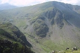
Dale Head is the apex of two hill ridges. The principal ridge descends from Dale Head to the north-east and forms several other fells, each given a chapter by Alfred Wainwright
in his Pictorial Guides to the Lakeland Fells. These are High Spy
, Maiden Moor
and Catbells
(alternative spelling, Cat Bells). This ridge forms the western side of Borrowdale
and overlooks Derwent Water
. The other ridge descends to the north-west and includes the fells of Hindscarth
and Robinson
; it overlooks Gatescarthdale and Buttermere
.
Dale Head is named for its position at the head of the Newlands Valley. This stretches away due north for three and a half miles before debouching into the floodplain of the Derwent between Derwentwater and Bassenthwaite Lake
. The eastern wall of the valley is formed by the High Spy to Catbells ridge, separating it from Borrowdale. Entering on the western side are a series of side valleys which drain the main mass of the North Western Fells. The source of Newlands Beck does not however flow from the apex of Dale Head as might be supposed from the name. Instead it has its birth at the col
between the main summit and the eastern top, High Scawdel (1,815 ft). The northern face of the fell forming the dalehead is ringed with crags. The main faces are Dalehead Crags and Great Gable, not to be confused with the fell of that name
.
The southern flank of the fell running down to the summit of the Honister Pass road (1,180 ft) has much gentler slopes, although there is outcropping rock on either side. Buckstone Hows and Yew Crag overshadow the road.From the top of the pass Gatesgarthdale Beck runs north west to Buttermere while Hause Gill flows east to Seatoller
and Borrowdale. Across the road is Grey Knotts
in the Western Fells.
The ridge to Hindscarth departs north west from the summit of Dale Head, soon narrowing into the fine and airy Hindscarth Edge. Both slopes are rocky, that to the south being known as Molds. Far Tongue Gill descends from the north of the ridge, a tributary of Newlands Beck.
Although High Scawdel stands east of the main summit, the high ground takes a great loop to the south around the head of Newlands Beck. It then drives north to the depression at Wilson's Bield (1,655 ft) before climbing to the summit of High Spy. The rest of the North Western Fells bear no tarns
worthy of the name, but Dale Head has two. On the northern slope near the source of Newlands Beck is Dalehead Tarn, while the smaller Launchy Tarn lies near the top of High Scawdel. Dalehead Tarn is a shallow pool providing a popular stopping place for walkers. Its varied flora include water horsetail, sedge and bogbean. Launchy Tarn is smaller and may have been formed by overgrazing and erosion of the underlying peat
.
slates to the north and the Borrowdale Volcanics to the south. On the northern flanks are outcrops of the Buttermere Formation, olistostrome
of disrupted sheared mudstone
, siltstone
and sandstone
. Southward march the Borrowdale series beginning with the plagioclase
-phyric andesite
lavas of the Birker Fell Formation, visible near the summit.
The fell has seen extensive mining history. Dale Head Mine was driven below the northern crags for copper
, several levels still being visible. Long Work was another copper mine a little further down the valley, worked for malachite
and pyrite
from Elizabethan times. On the southern flank of the fell, centred around the head of the pass, are the Honister Quarries. These are an extensive system of underground quarries, worked for Green Slate. The earliest extant records date from 1728 and since then huge caverns have been carved out on either side of the pass. The Yew Crag workings on the Dale Head side were operated until 1966, operations on the slopes of Grey Knotts continuing. In 1887 work began to drive a tunnel right under Dale Head into Newlands Valley, connecting with a proposed tramway to join the railway at Keswick. The scheme was abandoned after opposition from landowners. The main workers accommodation at the mine is now the Honister Hause Youth Hostel
.
 The summit is marked by a cairn
standing on the brink of the northern face. There is a fine end-on view of the Newlands Valley
to the north, backed by Skiddaw. All around are rank upon rank of fells, of the major Lakeland ranges only the High Street
group not being fully visible.
, where there is a car park and a youth hostel. The route ascends directly alongside a fence for approximately 2 kilometres and would take the average walker some 45 or 50 minutes. Longer routes begin at Little Town in the Newlands Valley, climbing either via Dalehead Tarn or the old access track to Dale Head Mine. From Borrowdale a start can be made at either Seatoller or Longthwaite, ascending first to Launchy Tarn and High Scawdel.
Fell
“Fell” is a word used to refer to mountains, or certain types of mountainous landscape, in Scandinavia, the Isle of Man, and parts of northern England.- Etymology :...
in the northwestern sector
North Western Fells
The North Western Fells are a group of hills in the English Lake District. Including such favourites as Catbells and Grisedale Pike, they occupy an oval area beneath the Buttermere and Borrowdale valley systems...
of the Lake District
Lake District
The Lake District, also commonly known as The Lakes or Lakeland, is a mountainous region in North West England. A popular holiday destination, it is famous not only for its lakes and its mountains but also for its associations with the early 19th century poetry and writings of William Wordsworth...
, in northern England
England
England is a country that is part of the United Kingdom. It shares land borders with Scotland to the north and Wales to the west; the Irish Sea is to the north west, the Celtic Sea to the south west, with the North Sea to the east and the English Channel to the south separating it from continental...
. It is 753 metres or 2,470 feet above sea level and stands immediately north of Honister Pass
Honister Pass
The Honister Pass, also known as Honister Hause, is a mountain pass in the English Lake District. It is located on the B5289 road, linking Seatoller, in the valley of Borrowdale, to Gatesgarth at the southern end of Buttermere...
, the road between Borrowdale
Borrowdale
Borrowdale is a valley and civil parish in the English Lake District in the Borough of Allerdale in Cumbria, England.Borrowdale lies within the historic county boundaries of Cumberland, and is sometimes referred to as Cumberland Borrowdale in order to distinguish it from another Borrowdale in the...
and Buttermere
Buttermere
Buttermere is a lake in the English Lake District in North West England. The adjacent village of Buttermere takes its name from the lake. Historically within the former county of Cumberland, the lake is now within the county of Cumbria. It is owned by the National Trust, forming part of their...
.
Topography
The North Western Fells occupy the area between the rivers Derwent and Cocker, a broadly oval swathe of hilly country, elongated on a north-south axis. Two roads cross from east to west, dividing the fells into three convenient groups. Dale Head is the highest fell in the southern sector.Dale Head is the apex of two hill ridges. The principal ridge descends from Dale Head to the north-east and forms several other fells, each given a chapter by Alfred Wainwright
Alfred Wainwright
Alfred Wainwright MBE was a British fellwalker, guidebook author and illustrator. His seven-volume Pictorial Guide to the Lakeland Fells, published between 1955 and 1966 and consisting entirely of reproductions of his manuscript, has become the standard reference work to 214 of the fells of the...
in his Pictorial Guides to the Lakeland Fells. These are High Spy
High Spy
High Spy is a fell in the English Lake District it is situated on the ridge that separates the Newlands Valley from Borrowdale, eight kilometres south of Keswick.-Topography:...
, Maiden Moor
Maiden Moor
Maiden Moor is a fell in the English Lake District, it stands south of the town of Keswick and is part of the high ground that separates the Newlands Valley and Borrowdale, it has a modest height of and so fails to be mentioned on many UK mountain lists but it does have a separate chapter in...
and Catbells
Catbells
Catbells is a fell in the English Lake District in the county of Cumbria. It has a modest height of but despite this it is one of the most popular fells in the area. It is situated on the western shore of Derwent Water within of the busy tourist town of Keswick...
(alternative spelling, Cat Bells). This ridge forms the western side of Borrowdale
Borrowdale
Borrowdale is a valley and civil parish in the English Lake District in the Borough of Allerdale in Cumbria, England.Borrowdale lies within the historic county boundaries of Cumberland, and is sometimes referred to as Cumberland Borrowdale in order to distinguish it from another Borrowdale in the...
and overlooks Derwent Water
Derwent Water
Derwentwater is one of the principal bodies of water in the Lake District National Park in north west England. It lies wholly within the Borough of Allerdale, in the county of Cumbria....
. The other ridge descends to the north-west and includes the fells of Hindscarth
Hindscarth
Hindscarth is a mountain between the valleys of Buttermere and Newlands, in the north-western part of the English Lake District. The fell's name is derived from two words from the Old Norse language, Hind and Skarth, and means the pass used by the red deer.-Topography:The North Western Fells occupy...
and Robinson
Robinson (Lake District)
thumb|Robinson seen from the [[Ard Crags]] ridge, with Hindscarth to the leftRobinson is a fell in the English Lake District, its southern slopes descending to Buttermere, while its northern side is set in the Newlands Valley...
; it overlooks Gatescarthdale and Buttermere
Buttermere
Buttermere is a lake in the English Lake District in North West England. The adjacent village of Buttermere takes its name from the lake. Historically within the former county of Cumberland, the lake is now within the county of Cumbria. It is owned by the National Trust, forming part of their...
.
Dale Head is named for its position at the head of the Newlands Valley. This stretches away due north for three and a half miles before debouching into the floodplain of the Derwent between Derwentwater and Bassenthwaite Lake
Bassenthwaite Lake
Bassenthwaite Lake is one of the largest water bodies in the English Lake District. It is long and narrow, approximately long and wide, but is also extremely shallow, with a maximum depth of about ....
. The eastern wall of the valley is formed by the High Spy to Catbells ridge, separating it from Borrowdale. Entering on the western side are a series of side valleys which drain the main mass of the North Western Fells. The source of Newlands Beck does not however flow from the apex of Dale Head as might be supposed from the name. Instead it has its birth at the col
Mountain pass
A mountain pass is a route through a mountain range or over a ridge. If following the lowest possible route, a pass is locally the highest point on that route...
between the main summit and the eastern top, High Scawdel (1,815 ft). The northern face of the fell forming the dalehead is ringed with crags. The main faces are Dalehead Crags and Great Gable, not to be confused with the fell of that name
Great Gable
Great Gable is a mountain lying at the very heart of the English Lake District, appearing as a pyramid from Wasdale , but as a dome from most other directions. It is one of the most popular of the Lakeland fells, and there are many different routes to the summit...
.
The southern flank of the fell running down to the summit of the Honister Pass road (1,180 ft) has much gentler slopes, although there is outcropping rock on either side. Buckstone Hows and Yew Crag overshadow the road.From the top of the pass Gatesgarthdale Beck runs north west to Buttermere while Hause Gill flows east to Seatoller
Seatoller
Seatoller is a settlement in Borrowdale in the English Lake District. It lies on the B5289 road at the east foot of the Honister Pass, and to the south of Derwent Water...
and Borrowdale. Across the road is Grey Knotts
Grey Knotts
Grey Knotts is a fell in the English Lake District, it is situated one kilometre south of the B5289 road as it crosses the Honister Pass, it is well seen from mid Borrowdale as it rises above Seatoller...
in the Western Fells.
The ridge to Hindscarth departs north west from the summit of Dale Head, soon narrowing into the fine and airy Hindscarth Edge. Both slopes are rocky, that to the south being known as Molds. Far Tongue Gill descends from the north of the ridge, a tributary of Newlands Beck.
Although High Scawdel stands east of the main summit, the high ground takes a great loop to the south around the head of Newlands Beck. It then drives north to the depression at Wilson's Bield (1,655 ft) before climbing to the summit of High Spy. The rest of the North Western Fells bear no tarns
Tarn (lake)
A tarn is a mountain lake or pool, formed in a cirque excavated by a glacier. A moraine may form a natural dam below a tarn. A corrie may be called a cirque.The word is derived from the Old Norse word tjörn meaning pond...
worthy of the name, but Dale Head has two. On the northern slope near the source of Newlands Beck is Dalehead Tarn, while the smaller Launchy Tarn lies near the top of High Scawdel. Dalehead Tarn is a shallow pool providing a popular stopping place for walkers. Its varied flora include water horsetail, sedge and bogbean. Launchy Tarn is smaller and may have been formed by overgrazing and erosion of the underlying peat
Peat
Peat is an accumulation of partially decayed vegetation matter or histosol. Peat forms in wetland bogs, moors, muskegs, pocosins, mires, and peat swamp forests. Peat is harvested as an important source of fuel in certain parts of the world...
.
Geology and Mining
Dale Head stands at the junction of the two main Lakeland geological systems, the SkiddawSkiddaw
Skiddaw is a mountain in the Lake District National Park in England. With a summit at 931 m above sea level it is the fourth highest mountain in England. It lies just north of the town of Keswick, Cumbria, and dominates the skyline in this part of the northern lakes...
slates to the north and the Borrowdale Volcanics to the south. On the northern flanks are outcrops of the Buttermere Formation, olistostrome
Olistostrome
The term olistostrome is derived from olio - a dish of many ingredients or stew; a mixture of heterogeneous elements; hodgepodge. and stroma - a bed covering...
of disrupted sheared mudstone
Mudstone
Mudstone is a fine grained sedimentary rock whose original constituents were clays or muds. Grain size is up to 0.0625 mm with individual grains too small to be distinguished without a microscope. With increased pressure over time the platey clay minerals may become aligned, with the...
, siltstone
Siltstone
Siltstone is a sedimentary rock which has a grain size in the silt range, finer than sandstone and coarser than claystones.- Description :As its name implies, it is primarily composed of silt sized particles, defined as grains 1/16 - 1/256 mm or 4 to 8 on the Krumbein phi scale...
and sandstone
Sandstone
Sandstone is a sedimentary rock composed mainly of sand-sized minerals or rock grains.Most sandstone is composed of quartz and/or feldspar because these are the most common minerals in the Earth's crust. Like sand, sandstone may be any colour, but the most common colours are tan, brown, yellow,...
. Southward march the Borrowdale series beginning with the plagioclase
Plagioclase
Plagioclase is an important series of tectosilicate minerals within the feldspar family. Rather than referring to a particular mineral with a specific chemical composition, plagioclase is a solid solution series, more properly known as the plagioclase feldspar series...
-phyric andesite
Andesite
Andesite is an extrusive igneous, volcanic rock, of intermediate composition, with aphanitic to porphyritic texture. In a general sense, it is the intermediate type between basalt and dacite. The mineral assemblage is typically dominated by plagioclase plus pyroxene and/or hornblende. Magnetite,...
lavas of the Birker Fell Formation, visible near the summit.
The fell has seen extensive mining history. Dale Head Mine was driven below the northern crags for copper
Copper
Copper is a chemical element with the symbol Cu and atomic number 29. It is a ductile metal with very high thermal and electrical conductivity. Pure copper is soft and malleable; an exposed surface has a reddish-orange tarnish...
, several levels still being visible. Long Work was another copper mine a little further down the valley, worked for malachite
Malachite
Malachite is a copper carbonate mineral, with the formula Cu2CO32. This green-colored mineral crystallizes in the monoclinic crystal system, and most often forms botryoidal, fibrous, or stalagmitic masses. Individual crystals are rare but do occur as slender to acicular prisms...
and pyrite
Pyrite
The mineral pyrite, or iron pyrite, is an iron sulfide with the formula FeS2. This mineral's metallic luster and pale-to-normal, brass-yellow hue have earned it the nickname fool's gold because of its resemblance to gold...
from Elizabethan times. On the southern flank of the fell, centred around the head of the pass, are the Honister Quarries. These are an extensive system of underground quarries, worked for Green Slate. The earliest extant records date from 1728 and since then huge caverns have been carved out on either side of the pass. The Yew Crag workings on the Dale Head side were operated until 1966, operations on the slopes of Grey Knotts continuing. In 1887 work began to drive a tunnel right under Dale Head into Newlands Valley, connecting with a proposed tramway to join the railway at Keswick. The scheme was abandoned after opposition from landowners. The main workers accommodation at the mine is now the Honister Hause Youth Hostel
Youth Hostels Association (England & Wales)
The Youth Hostels Association is a charitable organisation, registered with the Charity Commission, providing youth hostel accommodation in England and Wales...
.
Summit and view
Cairn
Cairn is a term used mainly in the English-speaking world for a man-made pile of stones. It comes from the or . Cairns are found all over the world in uplands, on moorland, on mountaintops, near waterways and on sea cliffs, and also in barren desert and tundra areas...
standing on the brink of the northern face. There is a fine end-on view of the Newlands Valley
Newlands Valley
The Newlands Valley is in the Lake District National Park in Cumbria, England. It is regarded as one of the most picturesque and quiet valleys in the national park, even though it is situated very close to the popular tourist town of Keswick and the busy A66 road.The valley forms part of the civil...
to the north, backed by Skiddaw. All around are rank upon rank of fells, of the major Lakeland ranges only the High Street
High Street (Lake District)
High Street is a fell in the English Lake District. At 828 metres , its summit is the highest point in the far eastern part of the national park. The fell is named after the Roman road which ran over the summit.-History and Naming:...
group not being fully visible.
Ascents
One of the most popular ascent routes of Dale Head begins from the summit of Honister PassHonister Pass
The Honister Pass, also known as Honister Hause, is a mountain pass in the English Lake District. It is located on the B5289 road, linking Seatoller, in the valley of Borrowdale, to Gatesgarth at the southern end of Buttermere...
, where there is a car park and a youth hostel. The route ascends directly alongside a fence for approximately 2 kilometres and would take the average walker some 45 or 50 minutes. Longer routes begin at Little Town in the Newlands Valley, climbing either via Dalehead Tarn or the old access track to Dale Head Mine. From Borrowdale a start can be made at either Seatoller or Longthwaite, ascending first to Launchy Tarn and High Scawdel.