
Bowfell
Encyclopedia
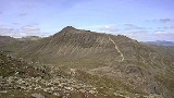
Bowfell is a pyramid
-shaped mountain lying at the heart of the English
Lake District
, in the Southern Fells
area. It is the sixth highest mountain
in the lakes and one of the most popular of the Lake District fell
s. It is listed in Alfred Wainwright's 'best half dozen' Lake District fells.
in the west and then curves around the north of Upper Eskdale to take in Great End
, Esk Pike
, Bowfell and Crinkle Crags
.
In addition to Eskdale, Bowfell has a footing in two other well known valleys. It stands at the head of Great Langdale
— its east ridge dividing the two branches of Mickleden and Oxendale — while to the north is the Langstrath branch of Borrowdale. From all of these valleys Bowfell presents a striking profile with a conical top resting upon a wider summit plateau.
To the north west of Bowfell the main ridge drops to the depression of Ore Gap, named after its reddish soil, rich in haematite. Below the col
on the northern side is Angle Tarn
. This round waterbody occupies a corrie
beneath Hanging Knotts, small trout lurking in its 50 ft depths. Its outflow is a tributary of the Langstrath Beck, making for Stonethwaite. To the south of Ore Gap runs Yeastyrigg Gill, the main headwater of Lingcove Beck, flowing into the fastness of upper Eskdale. Beyond the Gap the ridge makes the stoney three tiered climb to the white rocked summit of Esk Pike.
Southward of Bowfell the ridge falls steeply to Three Tarns, the col
separating it from Crinkle Crags. The depression takes its name from a number of small pools, often two, but sometimes more after rain. Busco Sike flowing to the east is the longest feeder of Oxendale Beck in Great Langdale.
Bowfell sends out two subsidiary ridges to the east. The Band is a descending rigg starting from the southern end of the summit plateau. It is this ridge which divides Oxendale from Mickleden, making straight for Stool End Farm on the valley floor. The Band has a minor top about halfway down named White Stones, although most guidebooks do not consider it notable. The second ridge begins at the northern end of the summit plateau and crosses a sharp depression at the head of Rossett Gill to make for Rossett Pike
. The continuation of this ridge provides the connection to the Central Fells, forming the northern wall of Great Langdale as it crosses Martcrag Moor, bound for the Langdale Pikes.
s of the Seathwaite Fell Formation, with interbeds of andesite
outcropping near the summit. The pebbly sandstone and breccia
s of the Pavey Ark Member also cross the fell.
The highest point carries not so much a cairn
as a rearrangement of some loose rock at the apex of the pyramid. The panorama
is excellent, improved immeasurably by the steep final slope and lack of foreground. Every major group of fells in Lakeland is seen well from this superb vantage point — the Helvellyn range
from end-to-end and the Langdale Pikes across Langdale — but the piece of the view is Scafell Pike
towering above Eskdale.
by following the Right of Way starting close to the Three Shire Stone
and heading in a northwesterly direction. The route takes in the summits of Cold Pike
and Long Top.
Pyramid
A pyramid is a structure whose outer surfaces are triangular and converge at a single point. The base of a pyramid can be trilateral, quadrilateral, or any polygon shape, meaning that a pyramid has at least three triangular surfaces...
-shaped mountain lying at the heart of the English
England
England is a country that is part of the United Kingdom. It shares land borders with Scotland to the north and Wales to the west; the Irish Sea is to the north west, the Celtic Sea to the south west, with the North Sea to the east and the English Channel to the south separating it from continental...
Lake District
Lake District
The Lake District, also commonly known as The Lakes or Lakeland, is a mountainous region in North West England. A popular holiday destination, it is famous not only for its lakes and its mountains but also for its associations with the early 19th century poetry and writings of William Wordsworth...
, in the Southern Fells
Southern Fells
Image:Annotated Scafell range.jpg|thumb|300px|The Scafellsrect 23 372 252 419 Slight Side rect 173 794 560 834 Scafell East Buttressrect 707 787 893 861 Esk Pike or Crag rect 245 303 409 358 Sca Fell rect 408 238 637 280 Mickledore Image:Annotated Scafell range.jpg|thumb|300px|The Scafellsrect 23...
area. It is the sixth highest mountain
Mountain
Image:Himalaya_annotated.jpg|thumb|right|The Himalayan mountain range with Mount Everestrect 58 14 160 49 Chomo Lonzorect 200 28 335 52 Makalurect 378 24 566 45 Mount Everestrect 188 581 920 656 Tibetan Plateaurect 250 406 340 427 Rong River...
in the lakes and one of the most popular of the Lake District fell
Fell
“Fell” is a word used to refer to mountains, or certain types of mountainous landscape, in Scandinavia, the Isle of Man, and parts of northern England.- Etymology :...
s. It is listed in Alfred Wainwright's 'best half dozen' Lake District fells.
Topography
The Southern Fells include the highest ground in England, a horseshoe which begins with Scafell and Scafell PikeScafell Pike
Scafell Pike is the highest mountain in England at . It is located in Lake District National Park sometimes confused with the neighbouring Sca Fell, to which it is connected by the col of Mickledore...
in the west and then curves around the north of Upper Eskdale to take in Great End
Great End
Great End is the most northerly mountain in the Scafell chain, in the English Lake District. From the south it is simply a lump continuing this chain....
, Esk Pike
Esk Pike
Esk Pike is a fell in the English Lake District, one of the great cirque of hills forming the head of Eskdale.-Topography:The Southern Fells include the highest ground in England, a horseshoe which begins with Scafell and Scafell Pike in the west and then curves around the north of Upper Eskdale to...
, Bowfell and Crinkle Crags
Crinkle Crags
Crinkle Crags is a fell in the English Lake District in the county of Cumbria. It forms part of two major rings of mountains, surrounding the valleys of Great Langdale and Upper Eskdale. The name reflects the fell's physical appearance as its summit ridge is a series of five rises and depressions ...
.
In addition to Eskdale, Bowfell has a footing in two other well known valleys. It stands at the head of Great Langdale
Great Langdale
Great Langdale is a valley in the Lake District National Park in the county of Cumbria, in the northwest of England. It is often simply referred to as Langdale, the epithet Great distinguishing it from the neighbouring valley of Little Langdale....
— its east ridge dividing the two branches of Mickleden and Oxendale — while to the north is the Langstrath branch of Borrowdale. From all of these valleys Bowfell presents a striking profile with a conical top resting upon a wider summit plateau.
To the north west of Bowfell the main ridge drops to the depression of Ore Gap, named after its reddish soil, rich in haematite. Below the col
Mountain pass
A mountain pass is a route through a mountain range or over a ridge. If following the lowest possible route, a pass is locally the highest point on that route...
on the northern side is Angle Tarn
Angle Tarn (Langstrath)
Angle Tarn is a tarn to the north of Bowfell in the English Lake District. It drains into Langstrath Beck....
. This round waterbody occupies a corrie
Cirque
Cirque may refer to:* Cirque, a geological formation* Makhtesh, an erosional landform found in the Negev desert of Israel and Sinai of Egypt*Cirque , an album by Biosphere* Cirque Corporation, a company that makes touchpads...
beneath Hanging Knotts, small trout lurking in its 50 ft depths. Its outflow is a tributary of the Langstrath Beck, making for Stonethwaite. To the south of Ore Gap runs Yeastyrigg Gill, the main headwater of Lingcove Beck, flowing into the fastness of upper Eskdale. Beyond the Gap the ridge makes the stoney three tiered climb to the white rocked summit of Esk Pike.
Southward of Bowfell the ridge falls steeply to Three Tarns, the col
Mountain pass
A mountain pass is a route through a mountain range or over a ridge. If following the lowest possible route, a pass is locally the highest point on that route...
separating it from Crinkle Crags. The depression takes its name from a number of small pools, often two, but sometimes more after rain. Busco Sike flowing to the east is the longest feeder of Oxendale Beck in Great Langdale.
Bowfell sends out two subsidiary ridges to the east. The Band is a descending rigg starting from the southern end of the summit plateau. It is this ridge which divides Oxendale from Mickleden, making straight for Stool End Farm on the valley floor. The Band has a minor top about halfway down named White Stones, although most guidebooks do not consider it notable. The second ridge begins at the northern end of the summit plateau and crosses a sharp depression at the head of Rossett Gill to make for Rossett Pike
Rossett Pike
Rossett Pike is a fell in the English Lake District. It is located at the head of Mickleden, one of two tributary valleys of Great Langdale.-Topography:...
. The continuation of this ridge provides the connection to the Central Fells, forming the northern wall of Great Langdale as it crosses Martcrag Moor, bound for the Langdale Pikes.
Geology
The predominant rocks on Bowfell are the volcaniclastic sandstoneSandstone
Sandstone is a sedimentary rock composed mainly of sand-sized minerals or rock grains.Most sandstone is composed of quartz and/or feldspar because these are the most common minerals in the Earth's crust. Like sand, sandstone may be any colour, but the most common colours are tan, brown, yellow,...
s of the Seathwaite Fell Formation, with interbeds of andesite
Andesite
Andesite is an extrusive igneous, volcanic rock, of intermediate composition, with aphanitic to porphyritic texture. In a general sense, it is the intermediate type between basalt and dacite. The mineral assemblage is typically dominated by plagioclase plus pyroxene and/or hornblende. Magnetite,...
outcropping near the summit. The pebbly sandstone and breccia
Breccia
Breccia is a rock composed of broken fragments of minerals or rock cemented together by a fine-grained matrix, that can be either similar to or different from the composition of the fragments....
s of the Pavey Ark Member also cross the fell.
Summit and View
The summit area is a ridge running north-south with the final pyramid near the southwest corner and crags on three sides. The southern face is formed by Bowfell Links, an impressive wall of crag scarred by nine vertical gullies and with corresponding tongues of scree at its foot. A climb up these is neither pleasurable nor safe as they are extremely active loose rock channels. The eastern face carries a wealth of features including Flat Crag, Cambridge Crag and the Bowfell Buttress, the latter two providing good climbing. Flat Crag includes the Great Slab, a remarkable tilted sheet of rock which looks exactly how it sounds. Below these faces runs the Climber's Traverse, a narrow path providing an excellent high-level walking route to the summit from the highest point of The Band. This largely horizontal line contours around beneath many of Bowfell's most dramatic crags, finally reaching the summit via a rocky route known as the River of Boulders, running parallel to the Great Slab. Finally on the north east corner of the summit ridge is Hanging Knotts, a complex series of faces and outcrops looking down upon Angle Tarn.The highest point carries not so much a cairn
Cairn
Cairn is a term used mainly in the English-speaking world for a man-made pile of stones. It comes from the or . Cairns are found all over the world in uplands, on moorland, on mountaintops, near waterways and on sea cliffs, and also in barren desert and tundra areas...
as a rearrangement of some loose rock at the apex of the pyramid. The panorama
Panorama
A panorama is any wide-angle view or representation of a physical space, whether in painting, drawing, photography, film/video, or a three-dimensional model....
is excellent, improved immeasurably by the steep final slope and lack of foreground. Every major group of fells in Lakeland is seen well from this superb vantage point — the Helvellyn range
Helvellyn range
Helvellyn range is the name given to a part of the Eastern Fells in the English Lake District, fell being the local word for hill. The name comes from Helvellyn, the highest point of the group....
from end-to-end and the Langdale Pikes across Langdale — but the piece of the view is Scafell Pike
Scafell Pike
Scafell Pike is the highest mountain in England at . It is located in Lake District National Park sometimes confused with the neighbouring Sca Fell, to which it is connected by the col of Mickledore...
towering above Eskdale.
Ascents
The Band provides the most popular means of ascent. Other routes from Langdale climb via Rossett Gill and Three Tarns. Bowfell can be reached from Stonethwaite via Angle Tarn although the way is long. Equally time consuming although perhaps more picturesque is the long march up Eskdale from Brotherikeld, gaining the ridge at either Ore Gap or Three Tarns. Indirect climbs can also be made via Crinkle Crags, Esk Pike or Rossett Pike. The summit can also be reached from the top of Wrynose PassWrynose Pass
The Wrynose Pass is a mountain pass in the Lake District National Park in Cumbria, England between the Duddon Valley and Little Langdale.-Road:...
by following the Right of Way starting close to the Three Shire Stone
Three Shire Stone (Lake District)
The Three Shire Stone is a boundary stone that marks the location where the historic English counties of Lancashire, Cumberland and Westmorland meet...
and heading in a northwesterly direction. The route takes in the summits of Cold Pike
Cold Pike
Cold Pike is a fell in the English Lake District. It is a satellite of Crinkle Crags and stands above the Upper Duddon Valley.-Topography:...
and Long Top.