
.gif)
Blue Line (Washington Metro)
Encyclopedia
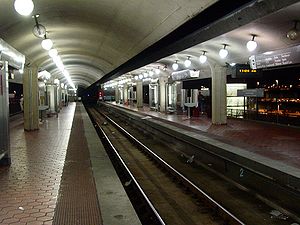
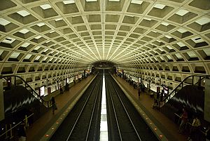
The Blue Line of the Washington Metro
in the United States consists of 27 rapid transit
stations
from Franconia–Springfield to Largo Town Center. It has stations in Fairfax County
, Alexandria
and Arlington
, Virginia
, the District of Columbia, and Prince George's County
, Maryland
. Thirteen of the line's stations are shared with the Orange Line
, and another portion is also shared by the Yellow Line
; only eight stations are exclusive to the Blue Line. Beginning in 2013, its stations between Rosslyn and Stadium-Armory will also be shared with the Silver Line
. The Blue Line is an integral part of the Washington Metropolitan Area Transit Authority
(WMATA) Metrorail system.
 Planning for Metro began with the Mass Transportation Survey in 1955 which attempted to forecast both freeway and mass transit systems sufficient to meet the needs of 1980. In 1959, the study's final report included two rapid transit lines which anticipated subways in downtown Washington. Because the plan called for extensive freeway construction within the District of Columbia, alarmed residents lobbied for federal legislation creating a moratorium on freeway construction through July 1, 1962. The National Capital Transportation Agency's 1962 Transportation in the National Capital Region report anticipated much of the present Blue Line route in Virginia with the route following the railroad right-of-way inside Arlington and Alexandria to Springfield. It did not include a route in Prince George's County. The route continued in rapid transit plans until the formation of WMATA.
With the formation of WMATA in October 1966, planning of the system shifted from federal hands to a regional body with representatives of the District, Maryland and Virginia. Congressional
route approval was no longer a key consideration. Instead, routes had to serve each local suburban jurisdiction to assure that they would approve bond referenda to finance the system. The Blue Line took much of its present form along along the Richmond, Fredericksburg and Potomac Railroad
right-of-way to Colchester, Virginia
, as construction along existing right-of-way is the least expensive way to built into the suburbs. In March 1968, the WMATA board approved its 98 miles (157.7 km) Adopted Regional System (ARS) which included the Blue Line from Huntington to Addison Road, with a possible extension to Largo. The ARS contained a Blue Line/Orange Line
station at Oklahoma Avenue between Stadium/Armory and the Anacostia River Bridge. Local residents objected to a proposed 1,000-car commuter parking lot
at that station and the traffic that it would generate in the neighborhood. In reaction to their lobbying, the DC government insisted that the station be removed and that the tunnel for the line be extended through the neighborhood. To better accommodate tourists, a Smithsonian station exit was added on the Mall and the federal government requested in 1972 that the Arlington Cemetery Station be added to the Blue Line. The federal government paid the cost of both design changes.
 Service on the Blue Line began on July 1, 1977, on 18 stations between National Airport in Arlington and Stadium-Armory in Washington – the first link of the Metro to Virginia
. The line was extended by three stations to Addison Road on November 22, 1980. Service south of National Airport began on June 15, 1991 when Van Dorn Street
opened. The original plan for the line was completed when this link was extended to Franconia–Springfield on June 29, 1997. Two new stations in Maryland
– Morgan Boulevard and Largo Town Center – opened on December 18, 2004.
From its opening on November 20, 1978, until December 11, 1979, the Orange Line was co-aligned with the Blue Line from National Airport to Stadium-Armory, with the Orange Line continuing east from Stadium-Armory to New Carrollton. Beginning December 1, 1979, the Orange Line diverged westward from Rosslyn to Ballston. The Blue and Orange Lines remain co-aligned from Rosslyn to Stadium-Armory, and the Silver Line
will eventually be co-signed along the same route as well.
 The Blue Line was originally planned to follow a slightly different route. The plan would have sent Blue Line trains to Huntington, with Yellow Line trains serving Franconia–Springfield. This was changed due to a shortage of rail cars at the time of the completion of the line to Huntington. Because fewer rail cars were required to operate Yellow Line service than would be required to run Blue Line service out to Huntington – due to the Yellow Line's shorter route – the line designations were switched. The line also the only line to have a station canceled due to neighborhood opposition. To be constructed as an above ground station in the parking lot north of RFK Stadium near Oklahoma Avenue, the station was canceled saving Metro $12 million and the alignment of the line was shifted slightly to the east to address neighbor concerns. From 1999 to 2008, the Blue Line operated to Huntington on July 4, as part of Metro's special Independence Day
service pattern.
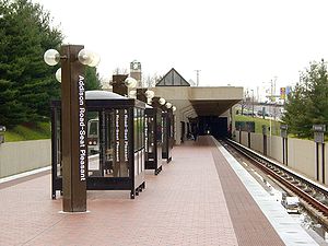
The ARS had the Blue Line end at Addison Road. However, sports fans continually argued for a three-mile (5 km) extension to the Capital Centre
sports arena in Largo, Maryland
. On February 27, 1997, the WMATA board approved construction of the extension. By the time the extension opened in 2004, professional basketball and hockey had relocated to a new arena atop the Gallery Place Station, and the Capital Centre was replaced with a shopping mall. However, the extension still drew considerable sport spectator traffic because it is within walking distance of the FedEx Field football stadium. The extension cost $456 million.
In 1998, Congress changed the name of the Washington National Airport to the Ronald Reagan Washington National Airport with the law specifying that no money be spent to implement the name change. As a result, WMATA did not change the name of the National Airport Station (which never included the full name of the airport). In response to repeated inquiries from Republican congressmen that the station be renamed, WMATA stated that stations are renamed only at the request of the local jurisdiction. Because both Arlington County and the District of Columbia were controlled by Democrats, the name change was blocked. Not until 2001 did Congress made changing the station's name a condition of further federal funding.
). The line travels above ground along the CSX Railroad right of way where it joins the Yellow Line just south of King Street in Old Town Alexandria. The joint line continues north along the CSX Railroad until it curves to the east on an elevated bridge adjacent to the National Airport terminal. The Blue Line then enters a subway tunnel under 15th Street South in Crystal City and bends north under Hayes Street and then The Pentagon
parking lots. The Blue Line separates from the Yellow Line in this tunnel and emerges on surface tracks that parallel Virginia Route 110 before entering a tunnel south of Rosslyn, where it merges with the Orange Line. The tunnel travels under North Lynn Street and then the Potomac River
where it bends to the east and travels under H Street NW. The tunnel bends south under 12th Street NW and crosses under the Red Line in the Metro Center station. The tunnel then turns east under D Street SW, where it passes under the Yellow and Green Lines in the L'Enfant Plaza station. The tunnel continues east under Pennsylvania Avenue SE, G Street SE and Potomac Avenue SE. The Blue Line then bends north under 19th Street SE and transitions to an elevated line in the RFK Stadium parking lot near Oklahoma Avenue NE. The Blue Line crosses the Anacostia River
on a bridge adjacent to Benning Road NE. At this point the line splits from the Orange Line and enters a tunnel under Benning Road and East Capitol Street. The Blue Line becomes a surface or elevated route with short tunnels parallel to Central Avenue from Addison Road – Seat Pleasant to its Eastern terminal at Largo Town Center, where it ends adjacent to the parking lots of "The Blvd
" shopping center.
In terms of WMATA's internal route designations, the Blue Line service travels along the entirety of the J Route (from the terminus at Franconia-Springfield to the C & J junction just south of King Street), part of the C Route (from the C & J junction just south of King Street to Metro Center), part of the D Route (from Metro Center to the D & G Junction just east of Stadium-Armory), and the entire G Route (from the D & G junction past Stadium-Armory to the terminus at Largo Town Center). The Blue Line needs 23 six-car trains (138 rail cars) to run at peak capacity.
area of Alexandria, Virginia, signed an agreement to construct a new station
between Braddock Road and National Airport that will be financed by the developer. As of February 2011, WMATA was taking public comments in order to prepare a draft environmental impact statement for the station. A second improvement project involves building a pedestrian tunnel to interconnect the Gallery Place station with Metro Center. A July 2005 study proposed connecting the eastern mezzanine of Metro Center with the western mezzanine of Gallery Place that are only one block apart. The proposed connection would reduce the number of passengers that use the Red Line to transfer between the Yellow Line and the Blue and Orange lines at Metro Center. As of 2011, the project remains unfunded.
Metro is currently considering rerouting the Blue Line to clear congestion around Rosslyn Station, where the Blue and Orange lines meet. The plan, which is still in the committee stage, calls for some Blue Line trains to continue on the usual route, while others would originate at Franconia–Springfield and be routed over the Fenwick Bridge to Greenbelt.
Washington Metro
The Washington Metro, commonly called Metro, and unofficially Metrorail, is the rapid transit system in Washington, D.C., United States, and its surrounding suburbs. It is administered by the Washington Metropolitan Area Transit Authority , which also operates Metrobus service under the Metro name...
in the United States consists of 27 rapid transit
Rapid transit
A rapid transit, underground, subway, elevated railway, metro or metropolitan railway system is an electric passenger railway in an urban area with a high capacity and frequency, and grade separation from other traffic. Rapid transit systems are typically located either in underground tunnels or on...
stations
Metro station
A metro station or subway station is a railway station for a rapid transit system, often known by names such as "metro", "underground" and "subway". It is often underground or elevated. At crossings of metro lines, they are multi-level....
from Franconia–Springfield to Largo Town Center. It has stations in Fairfax County
Fairfax County, Virginia
Fairfax County is a county in Virginia, in the United States. Per the 2010 Census, the population of the county is 1,081,726, making it the most populous jurisdiction in the Commonwealth of Virginia, with 13.5% of Virginia's population...
, Alexandria
Alexandria, Virginia
Alexandria is an independent city in the Commonwealth of Virginia. As of 2009, the city had a total population of 139,966. Located along the Western bank of the Potomac River, Alexandria is approximately six miles south of downtown Washington, D.C.Like the rest of northern Virginia, as well as...
and Arlington
Arlington County, Virginia
Arlington County is a county in the Commonwealth of Virginia. The land that became Arlington was originally donated by Virginia to the United States government to form part of the new federal capital district. On February 27, 1801, the United States Congress organized the area as a subdivision of...
, Virginia
Virginia
The Commonwealth of Virginia , is a U.S. state on the Atlantic Coast of the Southern United States. Virginia is nicknamed the "Old Dominion" and sometimes the "Mother of Presidents" after the eight U.S. presidents born there...
, the District of Columbia, and Prince George's County
Prince George's County, Maryland
Prince George's County is a county located in the U.S. state of Maryland, immediately north, east, and south of Washington, DC. As of 2010, it has a population of 863,420 and is the wealthiest African-American majority county in the nation....
, Maryland
Maryland
Maryland is a U.S. state located in the Mid Atlantic region of the United States, bordering Virginia, West Virginia, and the District of Columbia to its south and west; Pennsylvania to its north; and Delaware to its east...
. Thirteen of the line's stations are shared with the Orange Line
Orange Line (Washington Metro)
The Orange Line of the Washington Metro consists of 26 rapid transit stations from Vienna to New Carrollton. It has stations in Fairfax County and Arlington, Virginia, the District of Columbia, and Prince George's County, Maryland. Half of the line's stations are shared with the Blue Line, and over...
, and another portion is also shared by the Yellow Line
Yellow Line (Washington Metro)
The Yellow Line of the Washington Metro consists of 17 rapid transit stations from Huntington to Fort Totten. The line terminates at the Mount Vernon Square station during peak hours.Peak hours are 5 a.m. to 9:30 a.m. and 3 p.m. to 7 p.m. Service is extended to the Green Line stations during...
; only eight stations are exclusive to the Blue Line. Beginning in 2013, its stations between Rosslyn and Stadium-Armory will also be shared with the Silver Line
Silver Line (Washington Metro)
The Dulles Corridor Metrorail Project, formally dubbed the Silver Line, is an extension of the Washington Metro rapid transit system, currently under construction with the goal of providing rapid transit service to Dulles International Airport and Tysons Corner...
. The Blue Line is an integral part of the Washington Metropolitan Area Transit Authority
Washington Metropolitan Area Transit Authority
The Washington Metropolitan Area Transit Authority is a tri-jurisdictional government agency that operates transit service in the Washington, D.C. metropolitan area, including the Metrorail, Metrobus and MetroAccess...
(WMATA) Metrorail system.
History
With the formation of WMATA in October 1966, planning of the system shifted from federal hands to a regional body with representatives of the District, Maryland and Virginia. Congressional
United States Congress
The United States Congress is the bicameral legislature of the federal government of the United States, consisting of the Senate and the House of Representatives. The Congress meets in the United States Capitol in Washington, D.C....
route approval was no longer a key consideration. Instead, routes had to serve each local suburban jurisdiction to assure that they would approve bond referenda to finance the system. The Blue Line took much of its present form along along the Richmond, Fredericksburg and Potomac Railroad
Richmond, Fredericksburg and Potomac Railroad
The Richmond, Fredericksburg, and Potomac Railroad was a railroad connecting Richmond, Virginia, to Washington, D.C. It is now a portion of the CSX Transportation system....
right-of-way to Colchester, Virginia
Colchester, Virginia
Colchester is an unincorporated town on the Occoquan River in Fairfax County, Virginia. Colchester is a former tobacco port established in 1753. The port town was located on the old post road and Thomas Mason operated a ferry across the Occoquan River here. In 1798, Mason built a bridge across the...
, as construction along existing right-of-way is the least expensive way to built into the suburbs. In March 1968, the WMATA board approved its 98 miles (157.7 km) Adopted Regional System (ARS) which included the Blue Line from Huntington to Addison Road, with a possible extension to Largo. The ARS contained a Blue Line/Orange Line
Orange Line (Washington Metro)
The Orange Line of the Washington Metro consists of 26 rapid transit stations from Vienna to New Carrollton. It has stations in Fairfax County and Arlington, Virginia, the District of Columbia, and Prince George's County, Maryland. Half of the line's stations are shared with the Blue Line, and over...
station at Oklahoma Avenue between Stadium/Armory and the Anacostia River Bridge. Local residents objected to a proposed 1,000-car commuter parking lot
Park and ride
Park and ride facilities are car parks with connections to public transport that allow commuters and other people wishing to travel into city centres to leave their vehicles and transfer to a bus, rail system , or carpool for the rest of their trip...
at that station and the traffic that it would generate in the neighborhood. In reaction to their lobbying, the DC government insisted that the station be removed and that the tunnel for the line be extended through the neighborhood. To better accommodate tourists, a Smithsonian station exit was added on the Mall and the federal government requested in 1972 that the Arlington Cemetery Station be added to the Blue Line. The federal government paid the cost of both design changes.
Virginia
The Commonwealth of Virginia , is a U.S. state on the Atlantic Coast of the Southern United States. Virginia is nicknamed the "Old Dominion" and sometimes the "Mother of Presidents" after the eight U.S. presidents born there...
. The line was extended by three stations to Addison Road on November 22, 1980. Service south of National Airport began on June 15, 1991 when Van Dorn Street
Van Dorn Street (WMATA station)
Van Dorn Street is an island platformed Washington Metro station in both Fairfax County and Alexandria, Virginia, United States. The station was opened on June 15, 1991, and is operated by the Washington Metropolitan Area Transit Authority . Providing service for the Blue Line, the station is...
opened. The original plan for the line was completed when this link was extended to Franconia–Springfield on June 29, 1997. Two new stations in Maryland
Maryland
Maryland is a U.S. state located in the Mid Atlantic region of the United States, bordering Virginia, West Virginia, and the District of Columbia to its south and west; Pennsylvania to its north; and Delaware to its east...
– Morgan Boulevard and Largo Town Center – opened on December 18, 2004.
From its opening on November 20, 1978, until December 11, 1979, the Orange Line was co-aligned with the Blue Line from National Airport to Stadium-Armory, with the Orange Line continuing east from Stadium-Armory to New Carrollton. Beginning December 1, 1979, the Orange Line diverged westward from Rosslyn to Ballston. The Blue and Orange Lines remain co-aligned from Rosslyn to Stadium-Armory, and the Silver Line
Silver Line (Washington Metro)
The Dulles Corridor Metrorail Project, formally dubbed the Silver Line, is an extension of the Washington Metro rapid transit system, currently under construction with the goal of providing rapid transit service to Dulles International Airport and Tysons Corner...
will eventually be co-signed along the same route as well.
Independence Day (United States)
Independence Day, commonly known as the Fourth of July, is a federal holiday in the United States commemorating the adoption of the Declaration of Independence on July 4, 1776, declaring independence from the Kingdom of Great Britain...
service pattern.
The ARS had the Blue Line end at Addison Road. However, sports fans continually argued for a three-mile (5 km) extension to the Capital Centre
Capital Centre
The Capital Centre was an indoor arena located in Landover, Maryland, unincorporated Prince George's County, Maryland; a suburb of Washington, D.C. Completed in 1973, the arena sat 18,756 for basketball and 18,130 for hockey....
sports arena in Largo, Maryland
Largo, Maryland
Largo is an unincorporated area and census designated place in Prince George's County, Maryland, in the United States. The population was 8,408 at the 2000 census....
. On February 27, 1997, the WMATA board approved construction of the extension. By the time the extension opened in 2004, professional basketball and hockey had relocated to a new arena atop the Gallery Place Station, and the Capital Centre was replaced with a shopping mall. However, the extension still drew considerable sport spectator traffic because it is within walking distance of the FedEx Field football stadium. The extension cost $456 million.
In 1998, Congress changed the name of the Washington National Airport to the Ronald Reagan Washington National Airport with the law specifying that no money be spent to implement the name change. As a result, WMATA did not change the name of the National Airport Station (which never included the full name of the airport). In response to repeated inquiries from Republican congressmen that the station be renamed, WMATA stated that stations are renamed only at the request of the local jurisdiction. Because both Arlington County and the District of Columbia were controlled by Democrats, the name change was blocked. Not until 2001 did Congress made changing the station's name a condition of further federal funding.
Route
The southwestern terminal of the Blue Line is the Franconia–Springfield Station located at the intersection of Frontier Drive and the Franconia-Springfield Parkway (Virginia Route 7900Fairfax County Parkway
The Fairfax County Parkway, signed as State Route 7100, is a secondary state highway in the U.S. state of Virginia. It provides a north–south arterial route in Fairfax County with a mix of interchanges and signalized and unsignalized intersections. Its alignment roughly corresponds to part of...
). The line travels above ground along the CSX Railroad right of way where it joins the Yellow Line just south of King Street in Old Town Alexandria. The joint line continues north along the CSX Railroad until it curves to the east on an elevated bridge adjacent to the National Airport terminal. The Blue Line then enters a subway tunnel under 15th Street South in Crystal City and bends north under Hayes Street and then The Pentagon
The Pentagon
The Pentagon is the headquarters of the United States Department of Defense, located in Arlington County, Virginia. As a symbol of the U.S. military, "the Pentagon" is often used metonymically to refer to the Department of Defense rather than the building itself.Designed by the American architect...
parking lots. The Blue Line separates from the Yellow Line in this tunnel and emerges on surface tracks that parallel Virginia Route 110 before entering a tunnel south of Rosslyn, where it merges with the Orange Line. The tunnel travels under North Lynn Street and then the Potomac River
Potomac River
The Potomac River flows into the Chesapeake Bay, located along the mid-Atlantic coast of the United States. The river is approximately long, with a drainage area of about 14,700 square miles...
where it bends to the east and travels under H Street NW. The tunnel bends south under 12th Street NW and crosses under the Red Line in the Metro Center station. The tunnel then turns east under D Street SW, where it passes under the Yellow and Green Lines in the L'Enfant Plaza station. The tunnel continues east under Pennsylvania Avenue SE, G Street SE and Potomac Avenue SE. The Blue Line then bends north under 19th Street SE and transitions to an elevated line in the RFK Stadium parking lot near Oklahoma Avenue NE. The Blue Line crosses the Anacostia River
Anacostia River
The Anacostia River is a river in the Mid Atlantic region of the United States. It flows from Prince George's County in Maryland into Washington, D.C., where it joins with the Washington Channel to empty into the Potomac River at Buzzard Point. It is approximately long...
on a bridge adjacent to Benning Road NE. At this point the line splits from the Orange Line and enters a tunnel under Benning Road and East Capitol Street. The Blue Line becomes a surface or elevated route with short tunnels parallel to Central Avenue from Addison Road – Seat Pleasant to its Eastern terminal at Largo Town Center, where it ends adjacent to the parking lots of "The Blvd
The Boulevard at the Capital Centre
The Boulevard at the Capital Centre is an open-air shopping center located on the site of the former Capital Centre, which opened in December 1973 and was demolished in December 2002...
" shopping center.
In terms of WMATA's internal route designations, the Blue Line service travels along the entirety of the J Route (from the terminus at Franconia-Springfield to the C & J junction just south of King Street), part of the C Route (from the C & J junction just south of King Street to Metro Center), part of the D Route (from Metro Center to the D & G Junction just east of Stadium-Armory), and the entire G Route (from the D & G junction past Stadium-Armory to the terminus at Largo Town Center). The Blue Line needs 23 six-car trains (138 rail cars) to run at peak capacity.
Future plans
On November 16, 1995, WMATA and the developer of the Potomac YardPotomac Yard
Potomac Yard was one of the busiest rail yards on the Eastern Seaboard of the United States. Today, it refers to the neighborhood encompassing the same, which straddles southeastern Arlington County and northern Alexandria, Virginia, bounded by U.S. Route 1, the George Washington Memorial Parkway,...
area of Alexandria, Virginia, signed an agreement to construct a new station
Potomac Yard (WMATA station)
Potomac Yard is a planned island platformed Washington Metro station in Alexandria, Virginia, United States. Construction of the station is projected to commence in 2014 and it is scheduled to open in 2016. Potomac Yard station will be operated by the Washington Metropolitan Area Transit Authority...
between Braddock Road and National Airport that will be financed by the developer. As of February 2011, WMATA was taking public comments in order to prepare a draft environmental impact statement for the station. A second improvement project involves building a pedestrian tunnel to interconnect the Gallery Place station with Metro Center. A July 2005 study proposed connecting the eastern mezzanine of Metro Center with the western mezzanine of Gallery Place that are only one block apart. The proposed connection would reduce the number of passengers that use the Red Line to transfer between the Yellow Line and the Blue and Orange lines at Metro Center. As of 2011, the project remains unfunded.
Metro is currently considering rerouting the Blue Line to clear congestion around Rosslyn Station, where the Blue and Orange lines meet. The plan, which is still in the committee stage, calls for some Blue Line trains to continue on the usual route, while others would originate at Franconia–Springfield and be routed over the Fenwick Bridge to Greenbelt.