
Grand Western Canal
Encyclopedia
The Grand Western Canal ran between Taunton
in Somerset
and Tiverton in Devon
in the United Kingdom. The canal
had its origins in various plans, going back to 1796, to link the Bristol Channel
and the English Channel
by a canal, bypassing Lands End. An additional purpose of the canal was the supply of limestone
and coal
to lime kilns along with the removal of the resulting quicklime, which was used as a fertiliser and for building houses. This intended canal-link was never completed as planned, as the coming of the railways removed the need for its existence.
Construction was in two phases. A level section from Tiverton to Lowdwells on the Devon/Somerset border, opened in 1814, and was capable of carrying broad-beam barges, carrying up to 40 tons. The Somerset section, suitable for tub-boats, which were about 20 feet (6.1 m) long and capable of carrying eight tons, opened in 1839. It included an inclined plane
and seven boat lift
s, the earliest lifts to see commercial service in the UK. The lifts predated the Anderton Boat Lift
by nearly 40 years.
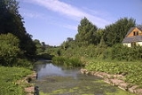
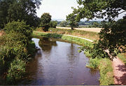
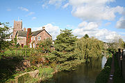
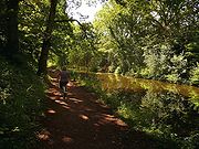
The 11 miles of Devon section remains open, despite various threats to its future, and is now a designated country park
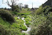
and local nature reserve, and allows navigation. The Somerset section was closed in 1867, and is gradually disappearing from the landscape, although sections are now used as a footpath. It maintains a historical interest and has been subject to some archaeological excavations.
 The Grand Western Canal was conceived as one of several competing schemes to alleviate the hazards and delays of coastal sailing ships making a passage around Land's End
to get between the Bristol Channel
and the English Channel
. A canal from the mouth of the River Exe
to Exeter
had been opened in 1566; and eight miles of the River Tone
had been made navigable in 1638. Navigation of the River Tone had been extended to Taunton
in 1717, by the construction of locks on the upper section.
Against this background, in 1768 a committee of men commissioned James Brindley
to survey a route, in the form of a canal, between Taunton and Exeter; and the survey was duly carried out by Robert Whitworth in 1769. This was to have been called the Exeter to Uphill Canal; as it involved a route from Topsham
or Exeter
to Taunton
, then the use of the River Tone
and a second canal from Burrow Bridge, via Bridgwater
, Glastonbury
, Wells
and Axbridge
, to Uphill
. Nothing further came of the plan until the 1790s, when various canal engineers were consulted, and in 1794 John Rennie was asked by a different committee, the Grand Western Canal Committee, to make another survey, which was adopted, and formed the basis for a planned Act of Parliament
. Opposition from the City of Exeter, who feared it would compete with the Exeter Canal
for transportation of coal
, was eventually softened; and the Act was passed on 24 March 1796.
The Act authorised a canal from Taunton to Topsham with branches to Tiverton and Cullompton
. Water supply would be derived from proposed reservoirs, one on the River Tone and two on the River Culm
, and from any other available sources within 2000 yd (1.8 km) of the line of the canal. The canal company was also authorised to improve the River Tone near Taunton, and to raise £220,000, plus an additional £110,000 if required. Navigation onwards from Taunton was via the River Tone and the River Parrett
. Construction did not start immediately.
 Finally in 1810, work started under the direction of John Thomas. Surprisingly, the decision was taken to start in the middle, with a 2.5 miles (4 km) section of the main line and the 9 miles (14 km) branch to Tiverton. The logic for this was that there was a large potential trade in limestone between quarries at Canonsleigh and Tiverton, and this would generate income. The summit level was cut 16 feet (5 m) lower than the original plans, so that no locks would be required, but this greatly increased the amount of earthworks required. A further Act was obtained in 1811 to sanction this, and to re-route the canal near Halberton
, where Rock Bridge was constructed to carry the road over the canal. The same engineers that built the canal also built a substantial country house, turnpike house and cottages at the site. Several other bridges, including Batten's Bridge, Crownhills Bridge, Greenway Bridge and Sellick Bridge were also constructed at Halberton to carry minor roads over the canal.
 With costs much higher than anticipated, work ceased in June 1811. After much deliberation, it was decided to continue construction, and to obtain a third Act of Parliament to authorise increased charges for carriage of goods. By 1812, progress was being made, but was hampered by the need for rock cuttings at Holcombe Rogus
. Leakage also meant that some sections needed to be lined with puddle clay
. Lime kilns were constructed to provide the materials, which can still be seen beside the canal, close to the Waytown Tunnel. Fenacre Bridge and Fossend Bridge were constructed at Burlescombe
, where culverts were also needed to manage the streams. At a total cost of £244,505, the canal was opened on 25 August 1814, when the first boat travelled from Lowdwells to Tiverton, laden with coal.
At Sampford Peverell
two rectories were built in 1836, at the expense of the Grand Western Canal Company, in compensation for cutting through the grounds and demolishing the south wing of the Old Rectory. Two road bridges were also needed in the village.
 Traffic on the opened section was much lower than anticipated, and the prospects of building the rest of the canal dwindled, as profits were minimal. However, in 1829 James Green
turned his attention to the link to Taunton. He had been the architect of the Bude Canal
, which was built for tub-boats
and used inclined planes to change levels, and proposed a similar solution here. The Bridgwater and Taunton Canal
had opened in 1827, making navigation from Taunton to Bridgwater
easier than on the River Tone. In a report of 1830, Green proposed using vertical lifts instead of inclined planes, and estimated the cost of the canal at £65,000.
Work started in 1831, and progressed quickly, including the construction of a bridge at Bradford on Tone
and Harpford Bridge at Langford Budville
, where a new warehouse was also built. In addition to the boat lift in Nynehead
two aqueducts were required within the village.
The route in Taunton was altered to connect to the Bridgwater and Taunton Canal directly, rather than using a short stretch of the River Tone. Seven lifts and one inclined plane were to be built, and it was these features that caused the subsequent delay in the completion of the canal. Teething problems with the design of the lifts gradually came to light, and although the cost of rectifying these was borne by Green, the canal could not be opened. There were also problems with the inclined plane. The canal was partially opened to Wellington
, in 1835; but in January 1836, Green was dismissed.
 Green's use of boat lifts was innovative. The idea was not new, as he acknowledged in an article describing the lifts which he published in Transactions in 1838, having been suggested in principle by a Dr James Anderson of Edinburgh in 1796. Robert Weldon had tried to build one on the Somersetshire Coal Canal
in 1798, which was replaced by an inclined plane after persistent failures. One was built at Ruabon
on the Ellesmere Canal
in 1796, but was replaced as it was not robust enough for regular use. James Fussell
built one on the abortive Dorset and Somerset Canal
, but the works were abandoned before it was ever used regularly. The lift at Tardebigge
on the Worcester and Birmingham Canal
was replaced by locks
in 1815 as it was "too complex and delicate", according to Rennie. Finally, another lift at Camden Town
on the Regent's Canal
was replaced by locks in 1815 because it could not be made to work.
In order to maintain the balance, a second chain was fixed to the bottom of the caisson, so that the total length of chain on each side of the lift remained the same. As a caisson descended, the chain coiled up at the bottom of the lift. The small amount of energy was created by ensuring that the ascending caisson was a little too low by the time the descending one reached the bottom. Thus it would hold a greater depth of water by the time it was ready to descend again. In practice, about 2 inches (5 cm) of water, weighing about a ton, was found to be sufficient.
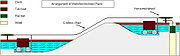 With the inclined plane, the problems stemmed from a mis-calculation. Power was provided by a large tank, filled with water, which descended in a shaft, raising one boat on a trolley and allowing another to descend as it did so. When the tank reached the bottom of the shaft, the water discharged, and the second tank was used to reverse the process. Green had been the engineer on the Bude Canal
, where this design had been used successfully, but the size of the tanks at Wellisford were much too small. On the Bude Canal, a tank holding 15 tons of water was required to raise a boat weighting six tons. The Grand Western Canal used boats holding eight tons, but the tanks only held ten tons of water, whereas tests indicated that about 25 tons was needed. It was for this reason that the steam engine was obtained to supply the power.
 The Somerset section of the canal was suitable for tub-boats, which were about 20 feet (6.1 m) long and capable of carrying eight tons. The Devon section was suitable for larger broad-beam barges, carrying up to 40 tons. Income from tolls increased steadily from £971 in 1835, rising to £2754 in 1838 and £4926 in 1844. At this point, competition from the railways started. The Bristol and Exeter Railway
reached Taunton in 1842 and Exeter in 1844. A branch to Tiverton was opened in 1848, and although the canal company received £1200 for loss of trade while an aqueduct was constructed over the line of the railway, deficits started to mount up almost immediately.
In 1853, with income no longer meeting operational costs, the canal was leased to the Bristol and Exeter Railway. From 1854, the company started to pay a dividend to its shareholders of 0.2%. Just ten years later, an Act of Parliament
was obtained to sell the canal to the railway company and to abandon the Somerset section of the canal. The transfer took place on 13 April 1865, and the tub-boat canal was closed in 1867. The lifts were dismantled, and most of the route sold back to the original landowners.
 Limestone traffic continued on the Tiverton section. Only two boats were working the canal by 1904, and the last commercial traffic was roadstone from Whipcott quarry to Tiverton, where there was a crushing plant. Around 7,000 tons per year were transported up to 1925. After this the only income was from the washing of sheep, for which a charge was made for every 20 sheep, and the sale of water lilies
which grew in the canal. In the 1930s, dams were built at both ends of a section near Halberton, where persistent leakage could not be cured.
Having passed into the ownership of the Great Western Railway
in 1888, the canal became the responsibility of the British Transport Commission
when the railways were nationalised in 1948, and was formally closed in 1962. The responsibility for it passed to the British Waterways Board in 1964.
 With various plans for using the route of the canal for landfill and for a bypass, some local interest was aroused regarding its future. The Tiverton Canal Preservation Committee was formed in 1962. This committee was stirred to action by plans in 1966 to infill parts of the canal so that housing could be built over it. Tiverton Borough Council gave the committee the power to negotiate with the British Waterways Board in March 1967, but the Board were unwilling to offer financial assistance.
Changes in legislation aided the cause. From 1968, county councils could set up country park
s, under the Countryside Act, and the Transport Act 1968
enabled the British Waterways Board to allow local authorities to maintain or purchase inland waterways. By 1969, BWB had stated that they were prepared to hand over the canal to Devon County Council, together with some money for maintenance. With some representatives within the council wavering, the preservation committee organised a walk along the entire canal on 18 October 1969. Around 400 walkers set off, with the local member of Parliament firing a starting gun, and by the time Tiverton was reached, the party totalled about 1200 people.
 By April 1970, the British Waterways Board had agreed to give the canal to Devon County Council, with £30,000 for maintenance. The actual contract was signed on 5 May 1971 at Tiverton Town Hall, when General Sir Hugh Stockwell
of the BWB also handed over a cheque for £38,750 to Colonel Eric Palmer, chairman of Devon County Council. The transfer of the canal was effective from 24 June 1971.
The new owners set to work immediately. The dry section was excavated and lined with a butyl
liner
to prevent leakage. The canal was reopened in 1971. Navigation is restricted to unpowered boats, with the exception of a maintenance boat that is used for cutting weed, while the final section from Fossend to Lowdwells, which would have been part of the original main line to Exeter
, is designated as a nature reserve
, and so all navigation and angling is discouraged. The canal is now a designated country park
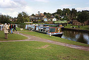
, and a horse-drawn tourist narrowboat runs from Tiverton.
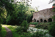
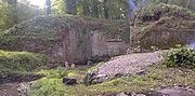
The Somerset section is largely dry and is gradually disappearing into the landscape, as a result of roads improvements and ploughing, but a footpath has been established along much of its route, and archaeological excavations of the lift at Nynehead
, the only one where there are still substantial remains, were carried out between 1998 and 2003 by the Somerset Industrial Archaeological Society.
Taunton
Taunton is the county town of Somerset, England. The town, including its suburbs, had an estimated population of 61,400 in 2001. It is the largest town in the shire county of Somerset....
in Somerset
Somerset
The ceremonial and non-metropolitan county of Somerset in South West England borders Bristol and Gloucestershire to the north, Wiltshire to the east, Dorset to the south-east, and Devon to the south-west. It is partly bounded to the north and west by the Bristol Channel and the estuary of the...
and Tiverton in Devon
Devon
Devon is a large county in southwestern England. The county is sometimes referred to as Devonshire, although the term is rarely used inside the county itself as the county has never been officially "shired", it often indicates a traditional or historical context.The county shares borders with...
in the United Kingdom. The canal
Canal
Canals are man-made channels for water. There are two types of canal:#Waterways: navigable transportation canals used for carrying ships and boats shipping goods and conveying people, further subdivided into two kinds:...
had its origins in various plans, going back to 1796, to link the Bristol Channel
Bristol Channel
The Bristol Channel is a major inlet in the island of Great Britain, separating South Wales from Devon and Somerset in South West England. It extends from the lower estuary of the River Severn to the North Atlantic Ocean...
and the English Channel
English Channel
The English Channel , often referred to simply as the Channel, is an arm of the Atlantic Ocean that separates southern England from northern France, and joins the North Sea to the Atlantic. It is about long and varies in width from at its widest to in the Strait of Dover...
by a canal, bypassing Lands End. An additional purpose of the canal was the supply of limestone
Limestone
Limestone is a sedimentary rock composed largely of the minerals calcite and aragonite, which are different crystal forms of calcium carbonate . Many limestones are composed from skeletal fragments of marine organisms such as coral or foraminifera....
and coal
Coal
Coal is a combustible black or brownish-black sedimentary rock usually occurring in rock strata in layers or veins called coal beds or coal seams. The harder forms, such as anthracite coal, can be regarded as metamorphic rock because of later exposure to elevated temperature and pressure...
to lime kilns along with the removal of the resulting quicklime, which was used as a fertiliser and for building houses. This intended canal-link was never completed as planned, as the coming of the railways removed the need for its existence.
Construction was in two phases. A level section from Tiverton to Lowdwells on the Devon/Somerset border, opened in 1814, and was capable of carrying broad-beam barges, carrying up to 40 tons. The Somerset section, suitable for tub-boats, which were about 20 feet (6.1 m) long and capable of carrying eight tons, opened in 1839. It included an inclined plane
Canal inclined plane
An inclined plane is a system used on some canals for raising boats between different water levels. Boats may be conveyed afloat, in caissons, or may be carried in cradles or slings. It can be considered as a specialised type of cable railway....
and seven boat lift
Boat lift
A boat lift, ship lift, or lift lock is a machine for transporting boats between water at two different elevations, and is an alternative to the canal lock and the canal inclined plane....
s, the earliest lifts to see commercial service in the UK. The lifts predated the Anderton Boat Lift
Anderton Boat Lift
The Anderton Boat Lift near the village of Anderton, Cheshire, in north-west England provides a vertical link between two navigable waterways: the River Weaver and the Trent and Mersey Canal....
by nearly 40 years.
The 11 miles of Devon section remains open, despite various threats to its future, and is now a designated country park
Country park
A country park is an area designated for people to visit and enjoy recreation in a countryside environment.-History:In the United Kingdom the term 'Country Park' has a special meaning. There are over 400 Country Parks in England alone . Most Country Parks were designated in the 1970s, under the...
and local nature reserve, and allows navigation. The Somerset section was closed in 1867, and is gradually disappearing from the landscape, although sections are now used as a footpath. It maintains a historical interest and has been subject to some archaeological excavations.
History
Land's End
Land's End is a headland and small settlement in west Cornwall, England, within the United Kingdom. It is located on the Penwith peninsula approximately eight miles west-southwest of Penzance....
to get between the Bristol Channel
Bristol Channel
The Bristol Channel is a major inlet in the island of Great Britain, separating South Wales from Devon and Somerset in South West England. It extends from the lower estuary of the River Severn to the North Atlantic Ocean...
and the English Channel
English Channel
The English Channel , often referred to simply as the Channel, is an arm of the Atlantic Ocean that separates southern England from northern France, and joins the North Sea to the Atlantic. It is about long and varies in width from at its widest to in the Strait of Dover...
. A canal from the mouth of the River Exe
River Exe
The River Exe in England rises near the village of Simonsbath, on Exmoor in Somerset, near the Bristol Channel coast, but flows more or less directly due south, so that most of its length lies in Devon. It reaches the sea at a substantial ria, the Exe Estuary, on the south coast of Devon...
to Exeter
Exeter
Exeter is a historic city in Devon, England. It lies within the ceremonial county of Devon, of which it is the county town as well as the home of Devon County Council. Currently the administrative area has the status of a non-metropolitan district, and is therefore under the administration of the...
had been opened in 1566; and eight miles of the River Tone
River Tone
The River Tone is a river in Somerset, England, which is about long. It rises at Beverton Pond near Huish Champflower in the Brendon Hills, and is dammed at Clatworthy Reservoir. The reservoir outfall continues through Taunton and Curry and Hay Moors, which are designated as a Site of Special...
had been made navigable in 1638. Navigation of the River Tone had been extended to Taunton
Taunton
Taunton is the county town of Somerset, England. The town, including its suburbs, had an estimated population of 61,400 in 2001. It is the largest town in the shire county of Somerset....
in 1717, by the construction of locks on the upper section.
Against this background, in 1768 a committee of men commissioned James Brindley
James Brindley
James Brindley was an English engineer. He was born in Tunstead, Derbyshire, and lived much of his life in Leek, Staffordshire, becoming one of the most notable engineers of the 18th century.-Early life:...
to survey a route, in the form of a canal, between Taunton and Exeter; and the survey was duly carried out by Robert Whitworth in 1769. This was to have been called the Exeter to Uphill Canal; as it involved a route from Topsham
Topsham, Devon
Topsham is a suburb of Exeter in the county of Devon, England, on the east side of the River Exe, immediately north of its confluence with the River Clyst and the former's estuary, between Exeter and Exmouth. Although village-sized, with a current population of around 5,023, it was designated a...
or Exeter
Exeter
Exeter is a historic city in Devon, England. It lies within the ceremonial county of Devon, of which it is the county town as well as the home of Devon County Council. Currently the administrative area has the status of a non-metropolitan district, and is therefore under the administration of the...
to Taunton
Taunton
Taunton is the county town of Somerset, England. The town, including its suburbs, had an estimated population of 61,400 in 2001. It is the largest town in the shire county of Somerset....
, then the use of the River Tone
River Tone
The River Tone is a river in Somerset, England, which is about long. It rises at Beverton Pond near Huish Champflower in the Brendon Hills, and is dammed at Clatworthy Reservoir. The reservoir outfall continues through Taunton and Curry and Hay Moors, which are designated as a Site of Special...
and a second canal from Burrow Bridge, via Bridgwater
Bridgwater
Bridgwater is a market town and civil parish in Somerset, England. It is the administrative centre of the Sedgemoor district, and a major industrial centre. Bridgwater is located on the major communication routes through South West England...
, Glastonbury
Glastonbury
Glastonbury is a small town in Somerset, England, situated at a dry point on the low lying Somerset Levels, south of Bristol. The town, which is in the Mendip district, had a population of 8,784 in the 2001 census...
, Wells
Wells
Wells is a cathedral city and civil parish in the Mendip district of Somerset, England, on the southern edge of the Mendip Hills. Although the population recorded in the 2001 census is 10,406, it has had city status since 1205...
and Axbridge
Axbridge
Axbridge is a town in Somerset, England, situated in the Sedgemoor district on the River Axe, near the southern edge of the Mendip Hills. The town population according to the 2001 census was 2,024.-History:...
, to Uphill
Uphill
Uphill is a village on the edge of Weston-super-Mare in North Somerset, England.-History:There is evidence of a port at Uphill since Roman times, probably for the export of lead from the Mendip Hills...
. Nothing further came of the plan until the 1790s, when various canal engineers were consulted, and in 1794 John Rennie was asked by a different committee, the Grand Western Canal Committee, to make another survey, which was adopted, and formed the basis for a planned Act of Parliament
Act of Parliament
An Act of Parliament is a statute enacted as primary legislation by a national or sub-national parliament. In the Republic of Ireland the term Act of the Oireachtas is used, and in the United States the term Act of Congress is used.In Commonwealth countries, the term is used both in a narrow...
. Opposition from the City of Exeter, who feared it would compete with the Exeter Canal
Exeter Canal
The Exeter Ship Canal, sometimes just called the Exeter Canal, downstream of Exeter, Devon, England was built in the 1560s which means it pre-dates the "canal mania" period and is one of the oldest artificial waterways in the UK.-History:...
for transportation of coal
Coal
Coal is a combustible black or brownish-black sedimentary rock usually occurring in rock strata in layers or veins called coal beds or coal seams. The harder forms, such as anthracite coal, can be regarded as metamorphic rock because of later exposure to elevated temperature and pressure...
, was eventually softened; and the Act was passed on 24 March 1796.
The Act authorised a canal from Taunton to Topsham with branches to Tiverton and Cullompton
Cullompton
Cullompton is a civil parish and town in Devon, England, locally known as Cully. It is miles north-north-east of Exeter and lies on the River Culm. In 2010 it had a population of 8,639 and is growing rapidly....
. Water supply would be derived from proposed reservoirs, one on the River Tone and two on the River Culm
River Culm
thumb|Old stone bridge with pedestrian refuges over River Culm at Culmstock The River Culm flows through Devon, England. It rises in the Blackdown Hills at a spring - - near Culmhead and flows west through Hemyock, then Culmstock to Uffculme...
, and from any other available sources within 2000 yd (1.8 km) of the line of the canal. The canal company was also authorised to improve the River Tone near Taunton, and to raise £220,000, plus an additional £110,000 if required. Navigation onwards from Taunton was via the River Tone and the River Parrett
River Parrett
The River Parrett flows through the counties of Dorset and Somerset in South West England, from its source in the Thorney Mills springs in the hills around Chedington in Dorset...
. Construction did not start immediately.
Construction
Halberton
Halberton is a village in Devon, England. The Grand Western Canal runs through the village. The village is situated between the historic market towns of Tiverton and Cullompton....
, where Rock Bridge was constructed to carry the road over the canal. The same engineers that built the canal also built a substantial country house, turnpike house and cottages at the site. Several other bridges, including Batten's Bridge, Crownhills Bridge, Greenway Bridge and Sellick Bridge were also constructed at Halberton to carry minor roads over the canal.
Holcombe Rogus
Holcombe Rogus is a village and civil parish in the English county of Devon. The population of the parish is 503.The manor house is described as "perhaps the finest Tudor house in Devon". The last element of the village's name – often mistranscribed as Regis – is that of the owner of...
. Leakage also meant that some sections needed to be lined with puddle clay
Puddling (engineering)
Puddle is a watertight material based on clay used in building and maintaining canals or reservoirs. Puddling is the process of lining the channel with puddle....
. Lime kilns were constructed to provide the materials, which can still be seen beside the canal, close to the Waytown Tunnel. Fenacre Bridge and Fossend Bridge were constructed at Burlescombe
Burlescombe
Burlescombe is a village and civil parish in the Mid Devon district of Devon, England. According to the 2001 census it had a population of 911. The village is about south west of Wellington in Somerset....
, where culverts were also needed to manage the streams. At a total cost of £244,505, the canal was opened on 25 August 1814, when the first boat travelled from Lowdwells to Tiverton, laden with coal.
At Sampford Peverell
Sampford Peverell
Sampford Peverell is a village in Mid-Devon, England. Its name reflects its inclusion in the Honour of Peverel, the lands of William Peverel and his family...
two rectories were built in 1836, at the expense of the Grand Western Canal Company, in compensation for cutting through the grounds and demolishing the south wing of the Old Rectory. Two road bridges were also needed in the village.
Second Phase
James Green (engineer)
James Green was a noted civil engineer and canal engineer, who was particularly active in the South West of England, where he pioneered the building of tub boat canals, and inventive solutions for coping with hilly terrain, which included tub boat lifts and inclined planes...
turned his attention to the link to Taunton. He had been the architect of the Bude Canal
Bude Canal
The Bude Canal was a canal built to serve the hilly hinterland in the Devon and Cornwall border territory in the United Kingdom, chiefly to bring lime-bearing sand for agricultural fertiliser. The Bude Canal system was one of the most unusual in Britain....
, which was built for tub-boats
Tub boat
A tub boat was a type of unpowered cargo boat used on a number of the early English and German canals. The English boats were typically long and wide and generally carried to of cargo, though some extra deep ones could carry up to . They are also called compartment boats or container boats.The...
and used inclined planes to change levels, and proposed a similar solution here. The Bridgwater and Taunton Canal
Bridgwater and Taunton Canal
The Bridgwater and Taunton Canal is a canal in the south-west of England between Bridgwater and Taunton, opened in 1827 and linking the River Tone to the River Parrett. There were a number of abortive schemes to link the Bristol Channel to the English Channel by waterway in the 18th and early 19th...
had opened in 1827, making navigation from Taunton to Bridgwater
Bridgwater
Bridgwater is a market town and civil parish in Somerset, England. It is the administrative centre of the Sedgemoor district, and a major industrial centre. Bridgwater is located on the major communication routes through South West England...
easier than on the River Tone. In a report of 1830, Green proposed using vertical lifts instead of inclined planes, and estimated the cost of the canal at £65,000.
Work started in 1831, and progressed quickly, including the construction of a bridge at Bradford on Tone
Bradford on Tone
Bradford on Tone is a village and civil parish in Somerset, England, situated on the River Tone south west of Taunton in the Taunton Deane district...
and Harpford Bridge at Langford Budville
Langford Budville
Langford Budville is a village and civil parish in Somerset, England, situated near the River Tone miles north-west of Wellington, from Wiveliscombe and west of Taunton in the Taunton Deane district. The parish includes the hamlets of Bindon, Lower Chipley, Lower Wellisford, Ramsey and Runnington...
, where a new warehouse was also built. In addition to the boat lift in Nynehead
Nynehead
Nynehead is a village and civil parish in Somerset, England, situated on the River Tone, south-west of Taunton and north-west of Wellington, in the Taunton Deane district. The village has a population of 416.-History:...
two aqueducts were required within the village.
The route in Taunton was altered to connect to the Bridgwater and Taunton Canal directly, rather than using a short stretch of the River Tone. Seven lifts and one inclined plane were to be built, and it was these features that caused the subsequent delay in the completion of the canal. Teething problems with the design of the lifts gradually came to light, and although the cost of rectifying these was borne by Green, the canal could not be opened. There were also problems with the inclined plane. The canal was partially opened to Wellington
Wellington, Somerset
Wellington is a small industrial town in rural Somerset, England, situated south west of Taunton in the Taunton Deane district, near the border with Devon, which runs along the Blackdown Hills to the south of the town...
, in 1835; but in January 1836, Green was dismissed.
Completion
The engineer W A Provis was asked to survey the works, and to report on the lifts and the causes of the failure of the plane. His clear report is an important source of information on the canal at the time of its construction. Some remedial work was instigated, following the report, including the provision of a steam engine to power the Wellisford incline. The 14 miles (22.5 km) extension was fully opened on 28 June 1838, at a cost of about £80,000.Boat Lifts
Somerset Coal Canal
The Somerset Coal Canal was a narrow canal in England, built around 1800 from basins at Paulton and Timsbury via Camerton, an aqueduct at Dunkerton, Combe Hay, Midford and Monkton Combe to Limpley Stoke where it joined the Kennet and Avon Canal...
in 1798, which was replaced by an inclined plane after persistent failures. One was built at Ruabon
Ruabon
Ruabon is a village and community in the county borough of Wrexham in Wales.More than 80% of the population of 2,400 were born in Wales with 13.6% speaking Welsh....
on the Ellesmere Canal
Ellesmere Canal
The Ellesmere Canal was a canal in England and Wales, originally planned to link the Rivers Mersey, Dee, and Severn, by running from Netherpool to Shrewsbury. The canal that was eventually constructed was very different from what was originally envisioned...
in 1796, but was replaced as it was not robust enough for regular use. James Fussell
James Fussell
James Fussell was the name of several men from the same family who established a business grinding edge tools and forging iron plates at several sites on the Mells River and its tributaries around Mells, Somerset, England...
built one on the abortive Dorset and Somerset Canal
Dorset and Somerset Canal
The Dorset and Somerset Canal was a proposed canal in the south west of England. The main line was intended to link Poole, in Dorset with the Kennet and Avon Canal near Bradford on Avon, Wiltshire. A branch was to go from the main line at Frome to the southern reaches of the Somerset coalfield at...
, but the works were abandoned before it was ever used regularly. The lift at Tardebigge
Tardebigge Locks
Tardebigge Locks or the Tardebigge Flight is the longest flight of locks in the UK, comprising 30 narrow locks on a two and a quarter mile stretch of the Worcester and Birmingham Canal at Tardebigge, Worcestershire...
on the Worcester and Birmingham Canal
Worcester and Birmingham Canal
The Worcester and Birmingham Canal is a canal linking Birmingham and Worcester in England. It starts in Worcester, as an 'offshoot' of the River Severn and ends in Gas Street Basin in Birmingham. It is long....
was replaced by locks
Tardebigge Locks
Tardebigge Locks or the Tardebigge Flight is the longest flight of locks in the UK, comprising 30 narrow locks on a two and a quarter mile stretch of the Worcester and Birmingham Canal at Tardebigge, Worcestershire...
in 1815 as it was "too complex and delicate", according to Rennie. Finally, another lift at Camden Town
Camden Town
-Economy:In recent years, entertainment-related businesses and a Holiday Inn have moved into the area. A number of retail and food chain outlets have replaced independent shops driven out by high rents and redevelopment. Restaurants have thrived, with the variety of culinary traditions found in...
on the Regent's Canal
Regent's Canal
Regent's Canal is a canal across an area just north of central London, England. It provides a link from the Paddington arm of the Grand Union Canal, just north-west of Paddington Basin in the west, to the Limehouse Basin and the River Thames in east London....
was replaced by locks in 1815 because it could not be made to work.
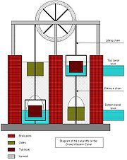
Principles
With no working prototypes, Green set about building seven lifts. The principle was simple. Two caissons were suspended from three carrying wheels of 16 feet (5 m) diameter, by wrought iron chains. The caisson at the bottom was jacked against the front wall of the lift to seal it, and a door or gate was opened to allow the boat to float in. The caisson at the top was jacked against the back wall in a similar manner. When both boats were in, the doors on the caissons and lift were closed, and the jacks released. Because a boat displaces its own weight in water, the system should be balanced, and a small amount of energy is required to start the boats moving. When the top caisson reaches the bottom, the jacks are applied, the doors are opened, and the boats can continue.In order to maintain the balance, a second chain was fixed to the bottom of the caisson, so that the total length of chain on each side of the lift remained the same. As a caisson descended, the chain coiled up at the bottom of the lift. The small amount of energy was created by ensuring that the ascending caisson was a little too low by the time the descending one reached the bottom. Thus it would hold a greater depth of water by the time it was ready to descend again. In practice, about 2 inches (5 cm) of water, weighing about a ton, was found to be sufficient.
Problems
The difficulty was that Anderson had suggested that the water in the caisson chambers should be at a lower level than that in the canal. This had not been implemented, and so the lower caisson would not sink deep enough for either boat to be floated out. Attempts to fit gates and to let the water in the chamber drain to waste had proved ineffective. Ultimately, lock chambers were built at the foot of the each lift. These were filled with water from the upper level, so that the boat could float out, and it then descended the final 3 foot (0.9144 m) as it would in a conventional lock. Only the lift at Greenham used Anderson's principle, and included a proper drain to lower the level in the chambers.Bude Canal
The Bude Canal was a canal built to serve the hilly hinterland in the Devon and Cornwall border territory in the United Kingdom, chiefly to bring lime-bearing sand for agricultural fertiliser. The Bude Canal system was one of the most unusual in Britain....
, where this design had been used successfully, but the size of the tanks at Wellisford were much too small. On the Bude Canal, a tank holding 15 tons of water was required to raise a boat weighting six tons. The Grand Western Canal used boats holding eight tons, but the tanks only held ten tons of water, whereas tests indicated that about 25 tons was needed. It was for this reason that the steam engine was obtained to supply the power.
Locations of the Boat Lifts
Operation
Bristol and Exeter Railway
The Bristol & Exeter Railway was a railway company formed to connect Bristol and Exeter.The company's head office was situated outside their Bristol station...
reached Taunton in 1842 and Exeter in 1844. A branch to Tiverton was opened in 1848, and although the canal company received £1200 for loss of trade while an aqueduct was constructed over the line of the railway, deficits started to mount up almost immediately.
In 1853, with income no longer meeting operational costs, the canal was leased to the Bristol and Exeter Railway. From 1854, the company started to pay a dividend to its shareholders of 0.2%. Just ten years later, an Act of Parliament
Act of Parliament
An Act of Parliament is a statute enacted as primary legislation by a national or sub-national parliament. In the Republic of Ireland the term Act of the Oireachtas is used, and in the United States the term Act of Congress is used.In Commonwealth countries, the term is used both in a narrow...
was obtained to sell the canal to the railway company and to abandon the Somerset section of the canal. The transfer took place on 13 April 1865, and the tub-boat canal was closed in 1867. The lifts were dismantled, and most of the route sold back to the original landowners.
Decline
Nymphaeaceae
Nymphaeaceae is a family of flowering plants. Members of this family are commonly called water lilies and live in freshwater areas in temperate and tropical climates around the world. The family contains eight genera. There are about 70 species of water lilies around the world. The genus...
which grew in the canal. In the 1930s, dams were built at both ends of a section near Halberton, where persistent leakage could not be cured.
Having passed into the ownership of the Great Western Railway
Great Western Railway
The Great Western Railway was a British railway company that linked London with the south-west and west of England and most of Wales. It was founded in 1833, received its enabling Act of Parliament in 1835 and ran its first trains in 1838...
in 1888, the canal became the responsibility of the British Transport Commission
British Transport Commission
The British Transport Commission was created by Clement Attlee's post-war Labour government as a part of its nationalisation programme, to oversee railways, canals and road freight transport in Great Britain...
when the railways were nationalised in 1948, and was formally closed in 1962. The responsibility for it passed to the British Waterways Board in 1964.
Restoration
Changes in legislation aided the cause. From 1968, county councils could set up country park
Country park
A country park is an area designated for people to visit and enjoy recreation in a countryside environment.-History:In the United Kingdom the term 'Country Park' has a special meaning. There are over 400 Country Parks in England alone . Most Country Parks were designated in the 1970s, under the...
s, under the Countryside Act, and the Transport Act 1968
Transport Act 1968
The Transport Act 1968 was an Act of the Parliament of the United Kingdom. The main provisions made changes to the structure of nationally owned bus companies, created passenger transport authorities and executives to take over public transport in large conurbations.-National Bus Company:The Act...
enabled the British Waterways Board to allow local authorities to maintain or purchase inland waterways. By 1969, BWB had stated that they were prepared to hand over the canal to Devon County Council, together with some money for maintenance. With some representatives within the council wavering, the preservation committee organised a walk along the entire canal on 18 October 1969. Around 400 walkers set off, with the local member of Parliament firing a starting gun, and by the time Tiverton was reached, the party totalled about 1200 people.
Handover
Hugh Stockwell
General Sir Hugh Charles Stockwell GCB, KBE, DSO & Bar was a British soldier, most remembered for commanding the Anglo-French ground forces during the Suez Crisis and his service as Deputy Supreme Allied Commander Europe of NATO from 1960 to 1964.-Early life:Stockwell was born in Jersey, but spent...
of the BWB also handed over a cheque for £38,750 to Colonel Eric Palmer, chairman of Devon County Council. The transfer of the canal was effective from 24 June 1971.
The new owners set to work immediately. The dry section was excavated and lined with a butyl
Butyl rubber
Butyl rubber is a synthetic rubber, a copolymer of isobutylene with isoprene. The abbreviation IIR stands for Isobutylene Isoprene Rubber. Polyisobutylene, also known as "PIB" or polyisobutene, n, is the homopolymer of isobutylene, or 2-methyl-1-propene, on which butyl rubber is based...
liner
Pond liner
A Pond liner is an impermeable geomembrane used for water retention, including the lining of lakes, garden ponds and artificial streams in parks and gardens. Pond liners need to be protected from sharp objects below the liner and from being punctured by any objects in the water body. Protection can...
to prevent leakage. The canal was reopened in 1971. Navigation is restricted to unpowered boats, with the exception of a maintenance boat that is used for cutting weed, while the final section from Fossend to Lowdwells, which would have been part of the original main line to Exeter
Exeter
Exeter is a historic city in Devon, England. It lies within the ceremonial county of Devon, of which it is the county town as well as the home of Devon County Council. Currently the administrative area has the status of a non-metropolitan district, and is therefore under the administration of the...
, is designated as a nature reserve
Nature reserve
A nature reserve is a protected area of importance for wildlife, flora, fauna or features of geological or other special interest, which is reserved and managed for conservation and to provide special opportunities for study or research...
, and so all navigation and angling is discouraged. The canal is now a designated country park
Country park
A country park is an area designated for people to visit and enjoy recreation in a countryside environment.-History:In the United Kingdom the term 'Country Park' has a special meaning. There are over 400 Country Parks in England alone . Most Country Parks were designated in the 1970s, under the...
, and a horse-drawn tourist narrowboat runs from Tiverton.
The Somerset section is largely dry and is gradually disappearing into the landscape, as a result of roads improvements and ploughing, but a footpath has been established along much of its route, and archaeological excavations of the lift at Nynehead
Nynehead
Nynehead is a village and civil parish in Somerset, England, situated on the River Tone, south-west of Taunton and north-west of Wellington, in the Taunton Deane district. The village has a population of 416.-History:...
, the only one where there are still substantial remains, were carried out between 1998 and 2003 by the Somerset Industrial Archaeological Society.
External links
- Grand Western Canal home page (on Devon County Council website)
- GWC Information