
River Tone
Encyclopedia
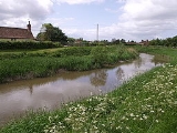
The River Tone is a river in Somerset
, England
, which is about 32 miles (51 km) long. It rises at Beverton Pond near Huish Champflower
in the Brendon Hills
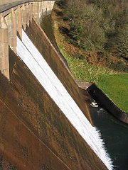
, and is dammed at Clatworthy Reservoir
. The reservoir outfall continues through Taunton
and Curry and Hay Moors
, which are designated as a Site of Special Scientific Interest
. Finally, it joins the River Parrett
at Burrowbridge
.
An act of Parliament
granted in 1699 authorised work that made the river navigable as far as Taunton
. The act spcified that profits should be used to benefit the poor of Taunton, but the Proprietors succeeded in avoiding their obligation until 1843, when they used the proceeds from the sale of the navigation to fund a wing of the Taunton and Somerset Hospital, and to aid the Taunton Market Trust.
The Bridgwater and Taunton Canal
opened in 1827, which provided an easier route than the river, and protracted legal battles followed over ownership of the river and water rights for the canal. These were not finally resolved until 1832, when the Canal Company formally took over the river navigation. The river gradually deteriorated, not helped by the abandonment of the River Parrett as a navigation in 1878. Following flooding in Taunton in 1960, much of the river between there and its mouth was straightened, and the navigation locks were removed. That at Ham was blown up by the Territorial Army. Navigation rights were repealed in 1967.
to Taunton, and has also been used to power mills along its length. These two objectives are often antagonistic, and this has been the case on the River Tone.
The earliest known record of improvements to the river is recorded in a document of 1325 from the Dean and Chapter of Wells Cathedral
, where it was proposed to widen the river between Ham Mill and a new mill which was to be built at Knapp. The Dean and Chapter owned the river as far as Athelney
weir, which was presumably a fish weir, as the river was an important source of fish for the local population. Records from 1494 record the intent to build a new mill at North Curry
, which was operational in 1504, and caused flooding in 1505, resulting in the Bishop of Winchester
having to complain to the Dean and Chapter of Wells
. There is also mention of boats using the river at this time, as their use was restricted by the construction of the new mill at Ham.
to Ham Mill was much easier than on the final stretch to Taunton, and in 1638, John Mallett, the Sheriff of Somerset
and Member of Parliament
for Bath
, obtained a Commission under the Great Seal from King Charles II
. This granted him and his heirs sole navigation rights from Bridgwater to Ham Mills, and allowed him to improve the river at his own expense. He saw this as a philanthropic action, as it reduced the price of coal to the poor people of Taunton, as well as improving the transport infrastructure.
With the death of Mallett and later his son, work on the maintenance of the river ceased, and its condition declined. By 1697, trade was threatened, and a group of 34 merchants and traders petitioned parliament for powers to take over the navigation. An Act of Parliament
dated 24 March 1699 created the Conservators of the River Tone, giving them powers "for making and keeping the River Tone navigable from Bridgewater to Taunton, in the county of Somerset", which included the purchase of the navigation rights from Bridgwater to Ham Mills from the Mallett estate, for which a price of £330 was agreed.
The Conservators applied for a second act of parliament in 1707, as they needed a further £3,800 to finance projects including the building of a half-lock and the removal of a shoal just below Knapp Bridge. Boats carrying 15 tons of cargo could reach Taunton by 1717. The navigation included a lock
and two or more half-locks, consisting of a pair of gates to hold back the water, and an agreement to build a towpath between Ham Mills and Taunton was reached in 1724.
The number of locks on the navigation varied over the years, and by 1804 there were four full or pound locks, situated at Ham, Creech St Michael
, Bathpool and Obridge. In addition, there were at least four half locks. Curry Moor gates were the lowest on the river, which were followed by a second half lock 100 yards (91.4 m) further upstream, just below Newbridge. A third gate was located 450 yards (411.5 m) below Ham lock, and the fourth one was just below the lock at Bathpool.
Profits for the undertaking showed a steady rise, due in part to the low maintenance costs of the river. Tolls rose from £321 in 1712 to £1,137 by 1802. By this time, traffic consisted of about 11,500 tons of coal carried from Bridgwater upstream out of a total tonnage of 14,000 tons. Dividends for 1797 were 11.5 per cent, but the capital debt had risen to £85,466 by 1800, when the auditors refused to examine the accounts, because the likelihood of the poor ever benefitting from the navigation was receding. After much negotiation, the capital debt was reduced to £13,000. An act of parliament dated 14 July 1804 enshrined this position, and ensured that interest was limited to six per cent, with profits being used to reduce the debt. By 1828, the amount owing had reduced to £4,426.
, which opened in 1827, directly affected the River Tone Navigation, as it provided a more direct route between Taunton and Bridgwater. The Conservators attempted to limit the supply of water from the river to the canal, while the canal company breached the river bank near Firepool lock, in order to ensure that boats could reach Taunton Bridge wharf from the canal. In order to compete with the canal, they chose to reduce the tolls, although they were unsure of the legality of this action while they had outstanding debts. The canal company challenged their right to reduce the tolls in court, but the action was defeated, and the tolls remained at the lower level.
On 28 August 1827, the canal company announced that they were taking over the River Tone Navigation, under the terms of their acts of parliament of 1811 and 1824. This they did in November, when William Goodland, the river superintendent, was evicted from his cottage, the tolls were raised again, and maintenance ceased. This action was ruled to be illegal by the Court of King's Bench
, as the canal company had not complied with the time limits enshrined in the act, but the canal company held on to the river despite the order to give it back to the conservators. Both sides took their case to the High Court, which ruled that the Conservators should have the river in February 1830. A further series of legal actions followed, after which the canal company attempted to obtain a new act of parliament to obtain the Tone by compulsory purchase. The Conservators then decided to negotiate, and an act of parliament passed in July 1832 authorised the takeover.
Under the terms of the act, the canal company inherited the debts of the Conservators, and paid them an additional £2,000. They were required to rebuild part of the North Town Bridge in Taunton, and to return the Tone Navigation to good order. The Conservators were empowered to carry out an annual inspection, and to re-possess the river if the canal was not properly maintained. The £2,000 was held by the Conservators until 1838, when they applied for an order to dispose of it, but it was not until 1843 that the order was granted. £1,000 was used to build a new wing for the Taunton and Somerset Hospital, and £1,000 was invested in the Taunton Market Trust, in line with the intentions of the 1699 act.
 Traffic on the river in 1823 was 39,516 tons, which generated tolls of £2,194. After the construction of the canal, traffic steadily declined, until income was insufficient to cover maintenance by the early 1860s. The canal company used a similar accounting practice to manage the Tone debt, inflating it at six per cent each year, to ensure that they could demonstrate that the river was unprofitable.
Navigation was further affected by the passing of the Somersetshire Drainage Act on 1 July 1878, which resulted in the River Parrett
being taken over by the Drainage Commissioners, and abandoned as a navigation. Limited traffic continued to use the lower reaches of the Tone, with the last barge using the Burrowbridge to Ham Mills section in 1929. In 1967 the Somerset River Authority applied to the Ministry of Agriculture
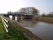
for permission to remove the navigation rights, and the original acts of parliament were repealed under section 41 of the Land Drainage Act (1930). This allowed the river through Taunton to be straightened, and a weir to be constructed at Firepool, to improve the flood defences for Taunton. Above the weir, the river is still navigable as far as French Weir.
Rainfall in October 1960 was even heavier, when 9.72 inches (246.9 mm) fell on the Somerset Levels, representing 249 per cent of the normal levels. Again the valley flooded, and large areas of Taunton were under water to a depth of 3 foot (0.9144 m). Plans for a flood relief channel centred at first on the Bridgwater to Taunton Canal, which follows a slightly higher course to the west, and does not run through peat, but the estimated cost of £1.7 million was prohibitive, and so a scheme to upgrade the river costing around one third of that was implemented. This involved straightening of the river where it meandered, widening the bridge openings, and the demolition of navigation locks and weirs.
A new sluice was constructed at Newbridge, incorporating tidal gates, which effectively prevent tides from passing further up the river. The removal of the navigation works at Ham proved particularly difficult, and acted as a training exercise for the Territorial Royal Engineers. Men from the 205 (Wessex) Field Squadron RE (TA) used 200 pounds (90.7 kg) of explosives to blow up the half-lock and a mud-filled barge which could not be moved. The river banks were raised to give more protection to the villages of Creech St Michael, Ham and Ruishton, but the channel was still only capable of discharging 2500 cuft/s, whereas the channels through Taunton were designed to handle 4500 cuft/s, and were unlikely to overflow until discharges reached 6000 cuft/s. Curry Moor is therefore used as a washland, and excess water floods over it, to be pumped out at a later date by the Curry Moor pumping station, situated on the banks of the river below the railway bridge. The programme began in 1965 and was completed in 1967.
The first Curry Moor pumping station was built in 1864, to house a steam engine and pump. A cottage for the operator was built next to it at the same time. This installation lasted until 1955, when a new pumphouse was constructed to house two diesel pumps. The steam engine was retained for historical reasons, and is located in part of the new building. The diesel pumps were supplemented by an electric pump in 1983, and a programme of refurbishment was carried out in 2008, which included the construction of a new outfall into the river.
 The river rises at Beverton Pond, at an elevation of 1230 ft (374.9 m), to the west of the B3190 road from Watchet
to Bampton
, and near to Huish Champflower barrow, an ancient earthworks, and the derelict incline of the West Somerset Mineral Railway
. Over its first 1.8 miles (2.9 km) it follows a south-easterly course and drops around 490 feet (149.4 m) before discharging into Clatworthy reservoir, which also impounds the waters of 5 other streams. The reservoir is an important wildlife habitat managed by Wessex Water
, and offers facilities for fishing and walking.
The river continues as the outflow from the main dam of the reservoir, passing to the west of the village of Clatworthy
before following a southerly course which passes to the east of Huish Champflower
. The river enters a steeply wooded section at Washbattle bridge, with the Dearne Valley Way footpath on its eastern bank. The B3227 road from Wiveliscombe
crosses from the east to the west side of the valley at Waterrow bridge, before heading westwards to Bampton, after which a former railway line crossed the river on its way to Taunton. By the time it reaches Stawley
bridge and turns south-east, it has lost another 410 ft (125 m) and is just 330 ft (100.6 m) above sea level. At Tracebridge, the river turns to the north-east and then the north. Here the course of the derelict Grand Western Canal
joins it.
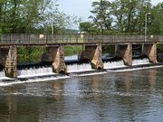
The river passes over weirs at Greenham, Tone and Nynehead, after which it is crossed by the aqueduct of the Grand Western Canal and the railway, both on their own routes to Taunton. A disused bridge, constructed in 1817, which carried the drive to Nynehead Court spans the river at Nynehead, and was Grade II listed in 1956. The river turns to the north-east near Bradford on Tone
, with its two Grade II listed bridges, originally built in the 15th century, and then to the east near Upcott bridge, where there were two mills. At Roughmoor its course is crossed by Silk Mills Road. A "Park and Ride" car park is situated just to the north, and there is a scheme to make the river navigable from here to the town centre as a way of encouraging transport with less environmental impact. Project Taunton, which is managing the regeneration of Taunton applied for a Big Lottery grant to fund this development, but were not successful, and so it may take longer to achieve.
 Soon the river reaches French weir, the head of navigation. As it makes its way through the town centre to Firepool weir and the junction with the Bridgwater and Taunton Canal
, it passes under the North Bridge, constructed in 1895 and including globe lamps which are thought to be part of the earliest electric street lighting scheme in a British town, and Priory Bridge Road. Next comes the A358 Obridge viaduct, the A38 Bathpool Bridge and the M5 motorway
bridge. Firepool weir was reconstructed in 1967 as part of the plans to straighten the river through the town centre and down to Bathpool in order to provide better flood defences. These works swept away the remains of the original navigation. A disused five-arched railway bridge built in 1863 and the aqueduct that carried the Chard Canal
over the river, used from 1842 until 1866, still stand, followed by the bridge at Creech St Michael
. Brewhouse Theatre
, which takes its name from the late 18th century brewery house which forms part of the complex, is close to the riverside. Ham weir stands as a reminder of the location of the lock there. After Knapp bridge, built in 1820 and Grade II listed, the sluice at Newbridge marks the upper tidal limit of the river. Curry and Hay Moors
, an area of low-lying fenland close to the river, are a Site of Special Scientific Interest
. A railway bridge carries the Taunton to Castle Cary
railway line over the river, after which is the Curry Moor pumping station. Two more road bridges at Athelney
and Stanmoor cross the river before it joins the River Parrett
at Burrowbridge, where the junction is overshadowed by Burrow Mump
, a prominent hill with a ruined chapel on the top.
as a grade II listed building.
Milling at Bathpool had a chequered history. There had been a mill at this location for several centuries, which had been rebuilt or adapted as required. In March 1812, the structure was burnt down by a fire, caused, according to the Taunton Courier, by "the excessive friction excited in the stones used in the process of shelling clover seeds". Stocks of flour, grain and flax valued at £2,500 were destroyed. The mill was rebuilt and later owned by Captain George Beadon. The mill was purchased by Thomas Redler in 1889 on the death of Beadon, but another fire damaged much of it two years later. Redler rebuilt it with safety in mind, and as at Ham, installed a steam-driven turbine as water levels were often inadequate to power the wheels. Two more turbines followed, and the water wheels were removed. Steam from the turbines was also used to heat bread ovens, which were amongst the first in the country to be heated in this way. In September 1915, another fire gutted the building, which was not rebuilt, and the ruins were demolished in the 1920s.
There were originally mills at Firepool and Obridge as well. Because of the difficulties of navigating past the mill pools, the Conservators of the River Tone decided to buy the mill at Firepool in December 1793 with a view to demolishing it "for the benefit of the navigation", and they obtained it for just £32. In 1797, they decided to follow the same course with Obridge Mill. The mill at Creech St Michael was the subject of a court action at the King's Bench. In October 1830, while replacing the mill stones, the millers had opened the flood gates for 16 days, and built a dam across the river, thus preventing navigation. The case was heard in 1831, and the judgement was that both parties were obligated to use the water in a way that did not cause injury to the other party.
Somerset
The ceremonial and non-metropolitan county of Somerset in South West England borders Bristol and Gloucestershire to the north, Wiltshire to the east, Dorset to the south-east, and Devon to the south-west. It is partly bounded to the north and west by the Bristol Channel and the estuary of the...
, England
England
England is a country that is part of the United Kingdom. It shares land borders with Scotland to the north and Wales to the west; the Irish Sea is to the north west, the Celtic Sea to the south west, with the North Sea to the east and the English Channel to the south separating it from continental...
, which is about 32 miles (51 km) long. It rises at Beverton Pond near Huish Champflower
Huish Champflower
Huish Champflower is a village and civil parish in Somerset, England, three miles north-west of Wiveliscombe and ten miles north of Wellington...
in the Brendon Hills
Brendon Hills
The Brendon Hills are composed of a lofty ridge of hills in the East Lyn Valley area of western Somerset, England. The terrain is broken by a series of deeply incised streams and rivers running roughly southwards to meet the River Haddeo, a tributary of the River Exe.The hills are quite heavily...
, and is dammed at Clatworthy Reservoir
Clatworthy Reservoir
Clatworthy Reservoir is situated near Clatworthy in the Brendon Hills on the edge of the Exmoor National Park in west Somerset, England. It is run by Wessex Water and has a capacity of , supplying some 200,000 homes...
. The reservoir outfall continues through Taunton
Taunton
Taunton is the county town of Somerset, England. The town, including its suburbs, had an estimated population of 61,400 in 2001. It is the largest town in the shire county of Somerset....
and Curry and Hay Moors
Curry and Hay Moors
Curry and Hay Moors is a 472.8 hectare biological Site of Special Scientific Interest in Somerset, notified in 1992.Curry and Hay Moors form part of the complex of grazing marshes known as the Somerset Levels and Moors. The low-lying site is situated adjacent to the River Tone which annually...
, which are designated as a Site of Special Scientific Interest
Site of Special Scientific Interest
A Site of Special Scientific Interest is a conservation designation denoting a protected area in the United Kingdom. SSSIs are the basic building block of site-based nature conservation legislation and most other legal nature/geological conservation designations in Great Britain are based upon...
. Finally, it joins the River Parrett
River Parrett
The River Parrett flows through the counties of Dorset and Somerset in South West England, from its source in the Thorney Mills springs in the hills around Chedington in Dorset...
at Burrowbridge
Burrowbridge
Burrowbridge is a village and civil parish in Somerset, England, situated on the River Parrett and A361 road south east of Bridgwater in the Taunton Deane district on the edge of the Somerset Levels...
.
An act of Parliament
Act of Parliament
An Act of Parliament is a statute enacted as primary legislation by a national or sub-national parliament. In the Republic of Ireland the term Act of the Oireachtas is used, and in the United States the term Act of Congress is used.In Commonwealth countries, the term is used both in a narrow...
granted in 1699 authorised work that made the river navigable as far as Taunton
Taunton
Taunton is the county town of Somerset, England. The town, including its suburbs, had an estimated population of 61,400 in 2001. It is the largest town in the shire county of Somerset....
. The act spcified that profits should be used to benefit the poor of Taunton, but the Proprietors succeeded in avoiding their obligation until 1843, when they used the proceeds from the sale of the navigation to fund a wing of the Taunton and Somerset Hospital, and to aid the Taunton Market Trust.
The Bridgwater and Taunton Canal
Bridgwater and Taunton Canal
The Bridgwater and Taunton Canal is a canal in the south-west of England between Bridgwater and Taunton, opened in 1827 and linking the River Tone to the River Parrett. There were a number of abortive schemes to link the Bristol Channel to the English Channel by waterway in the 18th and early 19th...
opened in 1827, which provided an easier route than the river, and protracted legal battles followed over ownership of the river and water rights for the canal. These were not finally resolved until 1832, when the Canal Company formally took over the river navigation. The river gradually deteriorated, not helped by the abandonment of the River Parrett as a navigation in 1878. Following flooding in Taunton in 1960, much of the river between there and its mouth was straightened, and the navigation locks were removed. That at Ham was blown up by the Territorial Army. Navigation rights were repealed in 1967.
History
The river has a long history of improvements to facilitate navigation from BridgwaterBridgwater
Bridgwater is a market town and civil parish in Somerset, England. It is the administrative centre of the Sedgemoor district, and a major industrial centre. Bridgwater is located on the major communication routes through South West England...
to Taunton, and has also been used to power mills along its length. These two objectives are often antagonistic, and this has been the case on the River Tone.
The earliest known record of improvements to the river is recorded in a document of 1325 from the Dean and Chapter of Wells Cathedral
Wells Cathedral
Wells Cathedral is a Church of England cathedral in Wells, Somerset, England. It is the seat of the Bishop of Bath and Wells, who lives at the adjacent Bishop's Palace....
, where it was proposed to widen the river between Ham Mill and a new mill which was to be built at Knapp. The Dean and Chapter owned the river as far as Athelney
Athelney
Athelney is located between the villages of Burrowbridge and East Lyng in the Sedgemoor district of Somerset, England. The area is known as the Isle of Athelney, because it was once a very low isolated island in the 'very great swampy and impassable marshes' of the Somerset Levels. Much of the...
weir, which was presumably a fish weir, as the river was an important source of fish for the local population. Records from 1494 record the intent to build a new mill at North Curry
North Curry
North Curry is a village and civil parish in Somerset, England, situated east of Taunton in the Taunton Deane district. The parish, which includes Knapp and Lower Knapp has a population of 1,625....
, which was operational in 1504, and caused flooding in 1505, resulting in the Bishop of Winchester
Winchester
Winchester is a historic cathedral city and former capital city of England. It is the county town of Hampshire, in South East England. The city lies at the heart of the wider City of Winchester, a local government district, and is located at the western end of the South Downs, along the course of...
having to complain to the Dean and Chapter of Wells
Wells
Wells is a cathedral city and civil parish in the Mendip district of Somerset, England, on the southern edge of the Mendip Hills. Although the population recorded in the 2001 census is 10,406, it has had city status since 1205...
. There is also mention of boats using the river at this time, as their use was restricted by the construction of the new mill at Ham.
River improvements
Navigation on the first 7 miles (11.3 km) from BurrowbridgeBurrowbridge
Burrowbridge is a village and civil parish in Somerset, England, situated on the River Parrett and A361 road south east of Bridgwater in the Taunton Deane district on the edge of the Somerset Levels...
to Ham Mill was much easier than on the final stretch to Taunton, and in 1638, John Mallett, the Sheriff of Somerset
High Sheriff of Somerset
The Office of High Sheriff of Somerset is an ancient High Sheriff title which has been in existence for over one thousand years. The position was once a powerful position responsible for collecting taxes and enforcing law and order in Somerset a county in South West England. In modern times the...
and Member of Parliament
Member of Parliament
A Member of Parliament is a representative of the voters to a :parliament. In many countries with bicameral parliaments, the term applies specifically to members of the lower house, as upper houses often have a different title, such as senate, and thus also have different titles for its members,...
for Bath
Bath (UK Parliament constituency)
Bath is a constituency in the House of Commons of the Parliament of the United Kingdom, previously of the House of Commons of England. It is an ancient constituency which has been constantly represented in Parliament since boroughs were first summoned to send members in the 13th century...
, obtained a Commission under the Great Seal from King Charles II
Charles II of England
Charles II was monarch of the three kingdoms of England, Scotland, and Ireland.Charles II's father, King Charles I, was executed at Whitehall on 30 January 1649, at the climax of the English Civil War...
. This granted him and his heirs sole navigation rights from Bridgwater to Ham Mills, and allowed him to improve the river at his own expense. He saw this as a philanthropic action, as it reduced the price of coal to the poor people of Taunton, as well as improving the transport infrastructure.
With the death of Mallett and later his son, work on the maintenance of the river ceased, and its condition declined. By 1697, trade was threatened, and a group of 34 merchants and traders petitioned parliament for powers to take over the navigation. An Act of Parliament
Act of Parliament
An Act of Parliament is a statute enacted as primary legislation by a national or sub-national parliament. In the Republic of Ireland the term Act of the Oireachtas is used, and in the United States the term Act of Congress is used.In Commonwealth countries, the term is used both in a narrow...
dated 24 March 1699 created the Conservators of the River Tone, giving them powers "for making and keeping the River Tone navigable from Bridgewater to Taunton, in the county of Somerset", which included the purchase of the navigation rights from Bridgwater to Ham Mills from the Mallett estate, for which a price of £330 was agreed.
The Conservators applied for a second act of parliament in 1707, as they needed a further £3,800 to finance projects including the building of a half-lock and the removal of a shoal just below Knapp Bridge. Boats carrying 15 tons of cargo could reach Taunton by 1717. The navigation included a lock
Lock (water transport)
A lock is a device for raising and lowering boats between stretches of water of different levels on river and canal waterways. The distinguishing feature of a lock is a fixed chamber in which the water level can be varied; whereas in a caisson lock, a boat lift, or on a canal inclined plane, it is...
and two or more half-locks, consisting of a pair of gates to hold back the water, and an agreement to build a towpath between Ham Mills and Taunton was reached in 1724.
The number of locks on the navigation varied over the years, and by 1804 there were four full or pound locks, situated at Ham, Creech St Michael
Creech St Michael
Creech St. Michael is a village and civil parish in Somerset, England, situated three miles east of Taunton in the Taunton Deane district. The village has a population of 2,464...
, Bathpool and Obridge. In addition, there were at least four half locks. Curry Moor gates were the lowest on the river, which were followed by a second half lock 100 yards (91.4 m) further upstream, just below Newbridge. A third gate was located 450 yards (411.5 m) below Ham lock, and the fourth one was just below the lock at Bathpool.
Profits
The 1699 act of parliament had stipulated that the Conservators could receive dividends of six per cent on the money they had invested into the undertaking, until the capital was repaid, and that after that the tolls were to be reduced, while profits were to be used for "the benefit and advantage of the poor of Taunton", particularly by the building of hospitals. Because the receipts were initially insufficient to cover the six per cent dividend on the £5,697 that the Conservators had invested, they added the difference to the capital, so that the debt steadily increased. This state of affairs was challenged in 1735, when it was decreed that the original capital had been repaid, and the poor should now benefit, but the decision was overturned in 1738 on appeal.Profits for the undertaking showed a steady rise, due in part to the low maintenance costs of the river. Tolls rose from £321 in 1712 to £1,137 by 1802. By this time, traffic consisted of about 11,500 tons of coal carried from Bridgwater upstream out of a total tonnage of 14,000 tons. Dividends for 1797 were 11.5 per cent, but the capital debt had risen to £85,466 by 1800, when the auditors refused to examine the accounts, because the likelihood of the poor ever benefitting from the navigation was receding. After much negotiation, the capital debt was reduced to £13,000. An act of parliament dated 14 July 1804 enshrined this position, and ensured that interest was limited to six per cent, with profits being used to reduce the debt. By 1828, the amount owing had reduced to £4,426.
Canal Company Takeover
The building of the Bridgwater and Taunton CanalBridgwater and Taunton Canal
The Bridgwater and Taunton Canal is a canal in the south-west of England between Bridgwater and Taunton, opened in 1827 and linking the River Tone to the River Parrett. There were a number of abortive schemes to link the Bristol Channel to the English Channel by waterway in the 18th and early 19th...
, which opened in 1827, directly affected the River Tone Navigation, as it provided a more direct route between Taunton and Bridgwater. The Conservators attempted to limit the supply of water from the river to the canal, while the canal company breached the river bank near Firepool lock, in order to ensure that boats could reach Taunton Bridge wharf from the canal. In order to compete with the canal, they chose to reduce the tolls, although they were unsure of the legality of this action while they had outstanding debts. The canal company challenged their right to reduce the tolls in court, but the action was defeated, and the tolls remained at the lower level.
On 28 August 1827, the canal company announced that they were taking over the River Tone Navigation, under the terms of their acts of parliament of 1811 and 1824. This they did in November, when William Goodland, the river superintendent, was evicted from his cottage, the tolls were raised again, and maintenance ceased. This action was ruled to be illegal by the Court of King's Bench
Court of King's Bench (England)
The Court of King's Bench , formally known as The Court of the King Before the King Himself, was an English court of common law in the English legal system...
, as the canal company had not complied with the time limits enshrined in the act, but the canal company held on to the river despite the order to give it back to the conservators. Both sides took their case to the High Court, which ruled that the Conservators should have the river in February 1830. A further series of legal actions followed, after which the canal company attempted to obtain a new act of parliament to obtain the Tone by compulsory purchase. The Conservators then decided to negotiate, and an act of parliament passed in July 1832 authorised the takeover.
Under the terms of the act, the canal company inherited the debts of the Conservators, and paid them an additional £2,000. They were required to rebuild part of the North Town Bridge in Taunton, and to return the Tone Navigation to good order. The Conservators were empowered to carry out an annual inspection, and to re-possess the river if the canal was not properly maintained. The £2,000 was held by the Conservators until 1838, when they applied for an order to dispose of it, but it was not until 1843 that the order was granted. £1,000 was used to build a new wing for the Taunton and Somerset Hospital, and £1,000 was invested in the Taunton Market Trust, in line with the intentions of the 1699 act.
Decline
Navigation was further affected by the passing of the Somersetshire Drainage Act on 1 July 1878, which resulted in the River Parrett
River Parrett
The River Parrett flows through the counties of Dorset and Somerset in South West England, from its source in the Thorney Mills springs in the hills around Chedington in Dorset...
being taken over by the Drainage Commissioners, and abandoned as a navigation. Limited traffic continued to use the lower reaches of the Tone, with the last barge using the Burrowbridge to Ham Mills section in 1929. In 1967 the Somerset River Authority applied to the Ministry of Agriculture
Ministry of Agriculture, Fisheries and Food
The Ministry of Agriculture, Fisheries and Food was a United Kingdom government department created by the Board of Agriculture Act 1889 and at that time called the Board of Agriculture, and then from 1903 the Board of Agriculture and Fisheries, and from 1919 the Ministry of Agriculture and Fisheries...
for permission to remove the navigation rights, and the original acts of parliament were repealed under section 41 of the Land Drainage Act (1930). This allowed the river through Taunton to be straightened, and a weir to be constructed at Firepool, to improve the flood defences for Taunton. Above the weir, the river is still navigable as far as French Weir.
Flood Defences
In 1951, very heavy rainfall resulted in large portions of the Tone valley below Taunton flooding. Analysis of what had happened indicated that the channel was of insufficient size to carry the volume of water, which fell on the hills to the west and then flowed down the river. The easy solution of widening the channel was not available, as there were houses built along the south-eastern bank for around 2 miles (3.2 km) above the junction with the River Parrett. The flooding revealed that although these properties were not normally affected by floods, there was significant seepage through the banks. There was no likelihood of sufficient money being available to buy all the houses to demolish them, and so a program of constructing concrete cores in the centre of the banks began in 1956 and continued until 1964.Rainfall in October 1960 was even heavier, when 9.72 inches (246.9 mm) fell on the Somerset Levels, representing 249 per cent of the normal levels. Again the valley flooded, and large areas of Taunton were under water to a depth of 3 foot (0.9144 m). Plans for a flood relief channel centred at first on the Bridgwater to Taunton Canal, which follows a slightly higher course to the west, and does not run through peat, but the estimated cost of £1.7 million was prohibitive, and so a scheme to upgrade the river costing around one third of that was implemented. This involved straightening of the river where it meandered, widening the bridge openings, and the demolition of navigation locks and weirs.
A new sluice was constructed at Newbridge, incorporating tidal gates, which effectively prevent tides from passing further up the river. The removal of the navigation works at Ham proved particularly difficult, and acted as a training exercise for the Territorial Royal Engineers. Men from the 205 (Wessex) Field Squadron RE (TA) used 200 pounds (90.7 kg) of explosives to blow up the half-lock and a mud-filled barge which could not be moved. The river banks were raised to give more protection to the villages of Creech St Michael, Ham and Ruishton, but the channel was still only capable of discharging 2500 cuft/s, whereas the channels through Taunton were designed to handle 4500 cuft/s, and were unlikely to overflow until discharges reached 6000 cuft/s. Curry Moor is therefore used as a washland, and excess water floods over it, to be pumped out at a later date by the Curry Moor pumping station, situated on the banks of the river below the railway bridge. The programme began in 1965 and was completed in 1967.
The first Curry Moor pumping station was built in 1864, to house a steam engine and pump. A cottage for the operator was built next to it at the same time. This installation lasted until 1955, when a new pumphouse was constructed to house two diesel pumps. The steam engine was retained for historical reasons, and is located in part of the new building. The diesel pumps were supplemented by an electric pump in 1983, and a programme of refurbishment was carried out in 2008, which included the construction of a new outfall into the river.
Route
Watchet
Watchet is a harbour town and civil parish in the English county of Somerset, with an approximate population of 4,400. It is situated west of Bridgwater, north-west of Taunton, and east of Minehead. The parish includes the hamlet of Beggearn Huish...
to Bampton
Bampton, Devon
Bampton is a small town in Devon, England close to the south-eastern corner of Exmoor and on the River Batherm, a tributary of the River Exe. It is about 10 km north of Tiverton.-History:...
, and near to Huish Champflower barrow, an ancient earthworks, and the derelict incline of the West Somerset Mineral Railway
West Somerset Mineral Railway
The West Somerset Mineral Railway was a line which operated in the UK county of Somerset. It ran from the ironstone mines in the Brendon Hills to the port of Watchet on the Bristol Channel. From there the ore was carried across by ship to Newport and thence to Ebbw Vale for smelting to extract...
. Over its first 1.8 miles (2.9 km) it follows a south-easterly course and drops around 490 feet (149.4 m) before discharging into Clatworthy reservoir, which also impounds the waters of 5 other streams. The reservoir is an important wildlife habitat managed by Wessex Water
Wessex Water
Wessex Water Services Limited, known as Wessex Water, is a water supply and sewerage utility company serving an area of the south west of England, covering 10,000 square kilometres including Dorset, Somerset, Bristol, most of Wiltshire and parts of Gloucestershire and Hampshire...
, and offers facilities for fishing and walking.
The river continues as the outflow from the main dam of the reservoir, passing to the west of the village of Clatworthy
Clatworthy
Clatworthy is a village and civil parish in the West Somerset District of Somerset, England. It is situated from Wellington and four miles from Wiveliscombe on the southern slopes of the Brendon Hills and close to the Exmoor National Park....
before following a southerly course which passes to the east of Huish Champflower
Huish Champflower
Huish Champflower is a village and civil parish in Somerset, England, three miles north-west of Wiveliscombe and ten miles north of Wellington...
. The river enters a steeply wooded section at Washbattle bridge, with the Dearne Valley Way footpath on its eastern bank. The B3227 road from Wiveliscombe
Wiveliscombe
Wiveliscombe is a town and civil parish in Somerset, England, situated west of Taunton in the Taunton Deane district. The town has a population of 2,670. The parish includes the nearby hamlet of Maundown.-History:...
crosses from the east to the west side of the valley at Waterrow bridge, before heading westwards to Bampton, after which a former railway line crossed the river on its way to Taunton. By the time it reaches Stawley
Stawley
Stawley is a village and civil parish in Somerset, England, situated west of Taunton in the Taunton Deane district. The parish has a population of 305 and includes the village of Kittisford and the hamlets of Appley, Greenham and Tracebridge.-History:The village was recorded in the Domesday Book...
bridge and turns south-east, it has lost another 410 ft (125 m) and is just 330 ft (100.6 m) above sea level. At Tracebridge, the river turns to the north-east and then the north. Here the course of the derelict Grand Western Canal
Grand Western Canal
The Grand Western Canal ran between Taunton in Somerset and Tiverton in Devon in the United Kingdom. The canal had its origins in various plans, going back to 1796, to link the Bristol Channel and the English Channel by a canal, bypassing Lands End...
joins it.
The river passes over weirs at Greenham, Tone and Nynehead, after which it is crossed by the aqueduct of the Grand Western Canal and the railway, both on their own routes to Taunton. A disused bridge, constructed in 1817, which carried the drive to Nynehead Court spans the river at Nynehead, and was Grade II listed in 1956. The river turns to the north-east near Bradford on Tone
Bradford on Tone
Bradford on Tone is a village and civil parish in Somerset, England, situated on the River Tone south west of Taunton in the Taunton Deane district...
, with its two Grade II listed bridges, originally built in the 15th century, and then to the east near Upcott bridge, where there were two mills. At Roughmoor its course is crossed by Silk Mills Road. A "Park and Ride" car park is situated just to the north, and there is a scheme to make the river navigable from here to the town centre as a way of encouraging transport with less environmental impact. Project Taunton, which is managing the regeneration of Taunton applied for a Big Lottery grant to fund this development, but were not successful, and so it may take longer to achieve.
Bridgwater and Taunton Canal
The Bridgwater and Taunton Canal is a canal in the south-west of England between Bridgwater and Taunton, opened in 1827 and linking the River Tone to the River Parrett. There were a number of abortive schemes to link the Bristol Channel to the English Channel by waterway in the 18th and early 19th...
, it passes under the North Bridge, constructed in 1895 and including globe lamps which are thought to be part of the earliest electric street lighting scheme in a British town, and Priory Bridge Road. Next comes the A358 Obridge viaduct, the A38 Bathpool Bridge and the M5 motorway
M5 motorway
The M5 is a motorway in England. It runs from a junction with the M6 at West Bromwich near Birmingham to Exeter in Devon. Heading south-west, the M5 runs east of West Bromwich and west of Birmingham through Sandwell Valley...
bridge. Firepool weir was reconstructed in 1967 as part of the plans to straighten the river through the town centre and down to Bathpool in order to provide better flood defences. These works swept away the remains of the original navigation. A disused five-arched railway bridge built in 1863 and the aqueduct that carried the Chard Canal
Chard Canal
The Chard Canal was a tub boat canal in Somerset, England, that ran from the Bridgwater and Taunton Canal at Creech St. Michael, over four aqueducts, through three tunnels and four inclined planes to Chard. It was completed in 1842, was never commercially viable, and closed in 1868...
over the river, used from 1842 until 1866, still stand, followed by the bridge at Creech St Michael
Creech St Michael
Creech St. Michael is a village and civil parish in Somerset, England, situated three miles east of Taunton in the Taunton Deane district. The village has a population of 2,464...
. Brewhouse Theatre
Brewhouse Theatre
The Brewhouse Theatre and Arts Centre is the largest theatre and arts centre in Taunton, the county town of Somerset, England.The building opened 28 March 1977 on the banks of the River Tone, and offers a 350 seat auditorium and supporting studio and exhibition spaces...
, which takes its name from the late 18th century brewery house which forms part of the complex, is close to the riverside. Ham weir stands as a reminder of the location of the lock there. After Knapp bridge, built in 1820 and Grade II listed, the sluice at Newbridge marks the upper tidal limit of the river. Curry and Hay Moors
Curry and Hay Moors
Curry and Hay Moors is a 472.8 hectare biological Site of Special Scientific Interest in Somerset, notified in 1992.Curry and Hay Moors form part of the complex of grazing marshes known as the Somerset Levels and Moors. The low-lying site is situated adjacent to the River Tone which annually...
, an area of low-lying fenland close to the river, are a Site of Special Scientific Interest
Site of Special Scientific Interest
A Site of Special Scientific Interest is a conservation designation denoting a protected area in the United Kingdom. SSSIs are the basic building block of site-based nature conservation legislation and most other legal nature/geological conservation designations in Great Britain are based upon...
. A railway bridge carries the Taunton to Castle Cary
Reading to Taunton line
The Reading to Taunton line also known as the Berks and Hants is a major branch of the Great Western Main Line that diverges at Reading, running to Cogload Junction near Taunton, where it joins the Bristol to Exeter line....
railway line over the river, after which is the Curry Moor pumping station. Two more road bridges at Athelney
Athelney
Athelney is located between the villages of Burrowbridge and East Lyng in the Sedgemoor district of Somerset, England. The area is known as the Isle of Athelney, because it was once a very low isolated island in the 'very great swampy and impassable marshes' of the Somerset Levels. Much of the...
and Stanmoor cross the river before it joins the River Parrett
River Parrett
The River Parrett flows through the counties of Dorset and Somerset in South West England, from its source in the Thorney Mills springs in the hills around Chedington in Dorset...
at Burrowbridge, where the junction is overshadowed by Burrow Mump
Burrow Mump
Burrow Mump is a hill and historic site overlooking Southlake Moor in the village of Burrowbridge in Taunton Deane, Somerset, England. It is a Scheduled Ancient Monument. Burrow Mump is also known as St Michael's Borough or Tutteyate...
, a prominent hill with a ruined chapel on the top.
Water Mills
Ham Mills was a site of milling activity from mediaeval times until about 1914. The mill was situated on an island in the middle of the river, with a weir and bypass channel to the north and the lock channel to the south. The Conservators were required to light the area after a boatman fell into the river and drowned while attempting to use the lock after dark in March 1826. The coroner who instructed that the lighting should be installed noted that "boats were passing at all hours of the night." Water levels in the river fell as more water was extracted further upstream, and by the 1890s the waterwheels were assisted by a steam-driven turbine which the miller installed. Milling ceased in 1914, when the boiler which supplied the steam was removed by the War Department, so that it could be fitted into a minesweeper. A surviving mill house which dates from the early 19th century has been designated by English HeritageEnglish Heritage
English Heritage . is an executive non-departmental public body of the British Government sponsored by the Department for Culture, Media and Sport...
as a grade II listed building.
Milling at Bathpool had a chequered history. There had been a mill at this location for several centuries, which had been rebuilt or adapted as required. In March 1812, the structure was burnt down by a fire, caused, according to the Taunton Courier, by "the excessive friction excited in the stones used in the process of shelling clover seeds". Stocks of flour, grain and flax valued at £2,500 were destroyed. The mill was rebuilt and later owned by Captain George Beadon. The mill was purchased by Thomas Redler in 1889 on the death of Beadon, but another fire damaged much of it two years later. Redler rebuilt it with safety in mind, and as at Ham, installed a steam-driven turbine as water levels were often inadequate to power the wheels. Two more turbines followed, and the water wheels were removed. Steam from the turbines was also used to heat bread ovens, which were amongst the first in the country to be heated in this way. In September 1915, another fire gutted the building, which was not rebuilt, and the ruins were demolished in the 1920s.
There were originally mills at Firepool and Obridge as well. Because of the difficulties of navigating past the mill pools, the Conservators of the River Tone decided to buy the mill at Firepool in December 1793 with a view to demolishing it "for the benefit of the navigation", and they obtained it for just £32. In 1797, they decided to follow the same course with Obridge Mill. The mill at Creech St Michael was the subject of a court action at the King's Bench. In October 1830, while replacing the mill stones, the millers had opened the flood gates for 16 days, and built a dam across the river, thus preventing navigation. The case was heard in 1831, and the judgement was that both parties were obligated to use the water in a way that did not cause injury to the other party.
See also
- Canals of the United KingdomCanals of the United KingdomThe canals of the United Kingdom are a major part of the network of inland waterways in the United Kingdom. They have a colourful history, from use for irrigation and transport, through becoming the focus of the Industrial Revolution, to today's role for recreational boating...
- History of the British canal systemHistory of the British canal systemThe British canal system of water transport played a vital role in the United Kingdom's Industrial Revolution at a time when roads were only just emerging from the medieval mud and long trains of pack horses were the only means of "mass" transit by road of raw materials and finished products The...