
Dorset and Somerset Canal
Encyclopedia
Canal
Canals are man-made channels for water. There are two types of canal:#Waterways: navigable transportation canals used for carrying ships and boats shipping goods and conveying people, further subdivided into two kinds:...
in the south west of England. The main line was intended to link Poole
Poole
Poole is a large coastal town and seaport in the county of Dorset, on the south coast of England. The town is east of Dorchester, and Bournemouth adjoins Poole to the east. The Borough of Poole was made a unitary authority in 1997, gaining administrative independence from Dorset County Council...
, in Dorset
Dorset
Dorset , is a county in South West England on the English Channel coast. The county town is Dorchester which is situated in the south. The Hampshire towns of Bournemouth and Christchurch joined the county with the reorganisation of local government in 1974...
with the Kennet and Avon Canal
Kennet and Avon Canal
The Kennet and Avon Canal is a waterway in southern England with an overall length of , made up of two lengths of navigable river linked by a canal. The name is commonly used to refer to the entire length of the navigation rather than solely to the central canal section...
near Bradford on Avon
Bradford on Avon
Bradford on Avon is a town in west Wiltshire, England with a population of about 9,326. The town's canal, historic buildings, shops, pubs and restaurants make it popular with tourists....
, Wiltshire
Wiltshire
Wiltshire is a ceremonial county in South West England. It is landlocked and borders the counties of Dorset, Somerset, Hampshire, Gloucestershire, Oxfordshire and Berkshire. It contains the unitary authority of Swindon and covers...
. A branch was to go from the main line at Frome
Frome
Frome is a town and civil parish in northeast Somerset, England. Located at the eastern end of the Mendip Hills, the town is built on uneven high ground, and centres around the River Frome. The town is approximately south of Bath, east of the county town, Taunton and west of London. In the 2001...
to the southern reaches of the Somerset coalfield
Somerset coalfield
The Somerset Coalfield included pits in the North Somerset, England, area where coal was mined from the 15th century until 1973.It is part of a wider coalfield which covered northern Somerset and southern Gloucestershire. It stretched from Cromhall in the north to the Mendip Hills in the south, and...
at Nettlebridge. Construction of the branch started in 1786, using boat lifts rather than locks to cope with changes of level, but the company ran out of money, and the canal was abandoned in 1803, never to be completed.
Proposals
Plans for a major canal to link BristolBristol
Bristol is a city, unitary authority area and ceremonial county in South West England, with an estimated population of 433,100 for the unitary authority in 2009, and a surrounding Larger Urban Zone with an estimated 1,070,000 residents in 2007...
and Poole, and therefore to make travel from the Bristol Channel
Bristol Channel
The Bristol Channel is a major inlet in the island of Great Britain, separating South Wales from Devon and Somerset in South West England. It extends from the lower estuary of the River Severn to the North Atlantic Ocean...
to the English Channel
English Channel
The English Channel , often referred to simply as the Channel, is an arm of the Atlantic Ocean that separates southern England from northern France, and joins the North Sea to the Atlantic. It is about long and varies in width from at its widest to in the Strait of Dover...
easier and safer, were proposed in 1792. The suggested route passed through Wareham
Wareham, Dorset
Wareham is an historic market town and, under the name Wareham Town, a civil parish, in the English county of Dorset. The town is situated on the River Frome eight miles southwest of Poole.-Situation and geography:...
, Sturminster Newton
Sturminster Newton
Sturminster Newton, known to locals as Stur, is a town in the Blackmore Vale area of Dorset, England. It is situated on a low limestone ridge in a meander of the River Stour. The town is at the centre of a large dairy agriculture region, around which the town's economy is built...
, Wincanton
Wincanton
Wincanton is a small town in south Somerset, southwest England. The town lies on the A303 road, the main route between London and South West England, and has some light industry...
and Frome
Frome
Frome is a town and civil parish in northeast Somerset, England. Located at the eastern end of the Mendip Hills, the town is built on uneven high ground, and centres around the River Frome. The town is approximately south of Bath, east of the county town, Taunton and west of London. In the 2001...
, joining the River Avon
River Avon, Bristol
The River Avon is an English river in the south west of the country. To distinguish it from a number of other River Avons in Britain, this river is often also known as the Lower Avon or Bristol Avon...
at Bath. Collieries in the Mendips near Nettlebridge were to be served by a branch canal, while the main trade was seen as coal travelling southwards and clay travelling northwards. A public meeting was held in Wincanton in January 1793, at which a list of subscribers was started.
There were several proposals as to the precise route, and so the canal engineer Robert Whitworth was asked to survey a route. By the time he reported back in September 1793, the route started from the Kennet and Avon Canal at Freshford near Limpley Stoke
Limpley Stoke
Limpley Stoke is a village and civil parish in Wiltshire, in the Avon Valley, between Bath and Freshford. The village is below the A36 road.The civil parish, which had a population of 637 in 2001, also includes the hamlet of Waterhouse, and the outskirts of the Somerset village of Midford. The 18th...
, rather than Bath, and having passed through Stalbridge
Stalbridge
Stalbridge is a small town and civil parish in Dorset, England, situated in the Blackmore Vale area of North Dorset district, near the border with Somerset. In 2001 the town had a population of 2,579, and is still growing. 30.8% of the inhabitants are retired...
, headed for Blandford rather than Wareham. The new route reflected the availability of water to supply the canal. Whitworth was busy and recommended that the projectors of the scheme should employ William Bennet
William Bennet (engineer)
William Bennet was an English civil engineer, noted for his work on canals. Nothing is known of his early life or family history, but details of his work from about 1790 until 1826 are documented...
of Frome as engineer. Bennet completed a detailed survey in 1795, estimating that the cost of the canal would be about £200,000, and the projectors approved most of his plan at a meeting in July. Short branches to Hamworthy
Hamworthy
Hamworthy is a parish and inner suburb of Poole in Dorset, England. Hamworthy lies on a peninsula of approximately and is bounded by Upton to the north, Poole Harbour to the west and Holes Bay to the east. Poole Bridge, the southern terminus of the A350 road, connects the suburb with the town centre...
and Wareham were added to the scheme, and the proposed junction with the Kennet and Avon Canal was later moved to Widford.
By the time parliamentary approval was sought, the southern end had been cut back to Shillingstone
Shillingstone
Shillingstone is a village in the Blackmore Vale area of north Dorset, England, situated on the River Stour between Sturminster Newton and Blandford Forum...
, to reduce the cost, and an Act of Parliament
Act of Parliament
An Act of Parliament is a statute enacted as primary legislation by a national or sub-national parliament. In the Republic of Ireland the term Act of the Oireachtas is used, and in the United States the term Act of Congress is used.In Commonwealth countries, the term is used both in a narrow...
was obtained on 24 March 1796, giving the company powers to raise £150,000, with an additional £75,000 if required. However, with the social changes and inflation that was occurring at the time, less than £80,000 was raised. With this, the company decided to start with the branch to Frome, in order to capitalise on the lucrative markets in the coal fields and the clothing industry in Frome.
Construction
Construction began on the branch line, and about 8 miles (12.9 km) of canal was built, from Stratton Common towards Frome, passing through Coleford and Vobster. The works included the three-arched Murtry AqueductMurtry Aqueduct
Murtry Aqueduct is a three-arched aqueduct that was intended to carry the Dorset and Somerset Canal over the Mells River, near Frome in Somerset, England. It is a grade II listed building.-Construction:...
over the Mells River
Mells River
The Mells River flows through the eastern Mendip Hills in Somerset, England. It rises at Gurney Slade and flows east joining the River Frome at Frome.The river forms one of the boundaries of Mells Manor a country house estate in Mells....
near Hapsford, a smaller aqueduct at Vallis Vale
Vallis Vale
Vallis Vale is a 23.9 hectare biological and geological Site of Special Scientific Interest near Great Elm in Somerset, notified in 1952.Vallis Vale is an ancient woodland site and supports an Ash-Wych Elm stand type with a restricted distribution in Britain.Vallis Vale exposes some of Britain’s...
, near Coleford
Coleford, Somerset
Coleford is a village and civil parish in Somerset, England, situated on the Mells River in the Mendip Hills five miles west of Frome. The village has a population of 2,350.-History:...
, and a tunnel at Goodeaves Farm, which was not completed.
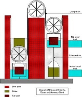
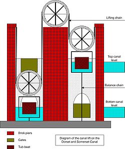
Both the main line and the branch involved significant changes in level, and the act had specified that conventional locks would be used on the main line, but that "caissons" would be used on the branch, which rose by 264 ft (80.5m) over its length. The idea of using vertical boat lifts was proposed by James Fussell
James Fussell
James Fussell was the name of several men from the same family who established a business grinding edge tools and forging iron plates at several sites on the Mells River and its tributaries around Mells, Somerset, England...
, owner of the nearby Mells
Mells, Somerset
Mells is a village and civil parish in Somerset, England, near the town of Frome.The parish includes the village of Vobster which had a coal mine of the same name on the Somerset coalfield and quarry, both of which are now disused. The old quarry is now used as a diving centre...
ironworks
Old Ironstone Works, Mells
Old Iron Works, Mells is a 0.25 hectare biological Site of Special Scientific Interest, in the Wadbury Valley, south of the village of Mells in Somerset, notified in 1987...
, and his particular design was patented in 1798. It consisted of two tanks, joined by chains which passed over large wheels. Boats entered one or both of the caissons, which each had an extra chamber below the main caisson, and the chamber of the top caisson was filled with water to provide the extra weight needed to cause the lift to operate. Although different in detail to those later used successfully on the Grand Western Canal
Grand Western Canal
The Grand Western Canal ran between Taunton in Somerset and Tiverton in Devon in the United Kingdom. The canal had its origins in various plans, going back to 1796, to link the Bristol Channel and the English Channel by a canal, bypassing Lands End...
, it was essentially very similar.
Fussell built the first boat lift at Barrow Hill. It was designed to take 10-ton boats, lifting them by 20 feet (6.1 m), and was tested during September and October 1800. It was formally demonstrated on 13 October 1800, and the Bath Chronicle carried a glowing report 3 days later.
Five more lifts were to be built on the Barrow Hill section, and works started on the pits for four of them, but the company ran out of money in 1802, with 1.7 miles (2.7 km) of canal still to be excavated and the boat lifts unfinished. Having consulted an engineer called Underhill, the company obtained a second act of parliament in 1803, to allow them to raise more money and to build railways instead of the canal if this would reduce the cost, but they were unable to raise any more finance. Construction ceased in 1803, and the canal was never completed.
The canal today
Several features are still visible including a bridge that once carried the Edford to Stratton Common road over the canal and an aqueduct at ColefordColeford, Somerset
Coleford is a village and civil parish in Somerset, England, situated on the Mells River in the Mendip Hills five miles west of Frome. The village has a population of 2,350.-History:...
, with two semi-circular arches nearly 33 feet (10.1 m) across and a similar height. The boat lift at Barrow Hill was the site of archaeological excavations in 2007. The three-arched aqueduct over the River Mells at Murtry Bottom still have some 56 feet (17.1 m) of retaining wall attached to it. A project to consider how best to conserve it has been aided by a grant from the Somerset Aggregates Levy Sustainability Fund.
See also
- Canals of Great Britain
- History of the British canal systemHistory of the British canal systemThe British canal system of water transport played a vital role in the United Kingdom's Industrial Revolution at a time when roads were only just emerging from the medieval mud and long trains of pack horses were the only means of "mass" transit by road of raw materials and finished products The...
- James FussellJames FussellJames Fussell was the name of several men from the same family who established a business grinding edge tools and forging iron plates at several sites on the Mells River and its tributaries around Mells, Somerset, England...
, canal promoter