

Oxford Canal
Encyclopedia
Canal
Canals are man-made channels for water. There are two types of canal:#Waterways: navigable transportation canals used for carrying ships and boats shipping goods and conveying people, further subdivided into two kinds:...
in central England linking Oxford
Oxford
The city of Oxford is the county town of Oxfordshire, England. The city, made prominent by its medieval university, has a population of just under 165,000, with 153,900 living within the district boundary. It lies about 50 miles north-west of London. The rivers Cherwell and Thames run through...
with Coventry
Coventry
Coventry is a city and metropolitan borough in the county of West Midlands in England. Coventry is the 9th largest city in England and the 11th largest in the United Kingdom. It is also the second largest city in the English Midlands, after Birmingham, with a population of 300,848, although...
via Banbury
Banbury
Banbury is a market town and civil parish on the River Cherwell in the Cherwell District of Oxfordshire. It is northwest of London, southeast of Birmingham, south of Coventry and north northwest of the county town of Oxford...
and Rugby
Rugby, Warwickshire
Rugby is a market town in Warwickshire, England, located on the River Avon. The town has a population of 61,988 making it the second largest town in the county...
. It connects with the River Thames at Oxford, to the Grand Union Canal
Grand Union Canal
The Grand Union Canal in England is part of the British canal system. Its main line connects London and Birmingham, stretching for 137 miles with 166 locks...
at the villages of Braunston and Napton-on-the-Hill
Napton-on-the-Hill
Napton-on-the-Hill, , is a village and civil parish east of Southam in Warwickshire, England.-Manor:...
, and to the Coventry Canal
Coventry Canal
The Coventry Canal is a navigable narrow canal in the Midlands of England.It starts in Coventry and ends 38 miles north at Fradley Junction, just north of Lichfield, where it joins the Trent and Mersey Canal...
at Hawkesbury Junction
Hawkesbury Junction
Hawkesbury Junction or Sutton Stop is a canal junction at the northern limit of the Oxford Canal where it meets the Coventry Canal, near Hawkesbury Village, Warwickshire, on the West Midlands county border, England...
in Bedworth
Bedworth
Bedworth is a market town in the Nuneaton and Bedworth district of Warwickshire, England. It lies northwest of London, east of Birmingham, and north northeast of the county town of Warwick. It is situated between Coventry, to the south, and Nuneaton, to the north.In the 2001 census the town...
just north of Coventry
Coventry
Coventry is a city and metropolitan borough in the county of West Midlands in England. Coventry is the 9th largest city in England and the 11th largest in the United Kingdom. It is also the second largest city in the English Midlands, after Birmingham, with a population of 300,848, although...
.
The Oxford Canal passes mainly through the Oxfordshire
Oxfordshire
Oxfordshire is a county in the South East region of England, bordering on Warwickshire and Northamptonshire , Buckinghamshire , Berkshire , Wiltshire and Gloucestershire ....
, Northamptonshire
Northamptonshire
Northamptonshire is a landlocked county in the English East Midlands, with a population of 629,676 as at the 2001 census. It has boundaries with the ceremonial counties of Warwickshire to the west, Leicestershire and Rutland to the north, Cambridgeshire to the east, Bedfordshire to the south-east,...
and Warwickshire
Warwickshire
Warwickshire is a landlocked non-metropolitan county in the West Midlands region of England. The county town is Warwick, although the largest town is Nuneaton. The county is famous for being the birthplace of William Shakespeare...
countryside, and is often considered to be one of the most scenic canals in Britain.
The canal was once an important artery of trade between the English Midlands
English Midlands
The Midlands, or the English Midlands, is the traditional name for the area comprising central England that broadly corresponds to the early medieval Kingdom of Mercia. It borders Southern England, Northern England, East Anglia and Wales. Its largest city is Birmingham, and it was an important...
and London
London
London is the capital city of :England and the :United Kingdom, the largest metropolitan area in the United Kingdom, and the largest urban zone in the European Union by most measures. Located on the River Thames, London has been a major settlement for two millennia, its history going back to its...
, but is now highly popular among pleasure boaters.
North of Napton-on-the-Hill, the canal forms part of the Warwickshire ring
Warwickshire ring
The Warwickshire ring is a connected series of canals forming a circuit around the West Midlands area of England. The ring is formed from the Coventry Canal, the Oxford Canal, the Grand Union Canal, the Stratford-upon-Avon Canal and the Birmingham and Fazeley Canal...
.
The route
Hawkesbury Village
Hawkesbury Village is in Warwickshire, England and is located within the Coventry–Bedworth urban area. It borders the city of Coventry at its southern point. It is situated within the Poplar Ward of the Nuneaton and Bedworth Borough Council area....
at Hawkesbury Junction, also known as Sutton Stop, where it connects with the Coventry Canal
Coventry Canal
The Coventry Canal is a navigable narrow canal in the Midlands of England.It starts in Coventry and ends 38 miles north at Fradley Junction, just north of Lichfield, where it joins the Trent and Mersey Canal...
, four miles from the centre of Coventry
Coventry
Coventry is a city and metropolitan borough in the county of West Midlands in England. Coventry is the 9th largest city in England and the 11th largest in the United Kingdom. It is also the second largest city in the English Midlands, after Birmingham, with a population of 300,848, although...
. From Hawkesbury, it runs south east through the Warwickshire
Warwickshire
Warwickshire is a landlocked non-metropolitan county in the West Midlands region of England. The county town is Warwick, although the largest town is Nuneaton. The county is famous for being the birthplace of William Shakespeare...
countryside for 15 miles (24.1 km) to Rugby
Rugby, Warwickshire
Rugby is a market town in Warwickshire, England, located on the River Avon. The town has a population of 61,988 making it the second largest town in the county...
.
The route between Coventry and Rugby is on a level with no locks
Lock (water transport)
A lock is a device for raising and lowering boats between stretches of water of different levels on river and canal waterways. The distinguishing feature of a lock is a fixed chamber in which the water level can be varied; whereas in a caisson lock, a boat lift, or on a canal inclined plane, it is...
, apart from the stop lock at the junction. Much of this section of the canal was straightened out in the 1820s, and remains of the original less direct route can still be seen in places.
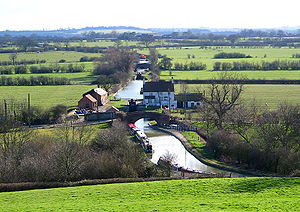
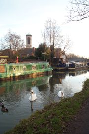
The canal winds through the northern part of Rugby passing through the 270 yards (246.9 m) long Newbold Tunnel, and then reaches a set of three locks at Hillmorton
Hillmorton
Hillmorton is an area of the town of Rugby, Warwickshire, it comprises most of the eastern half of the town.Hillmorton was historically a village in its own right, and was mentioned in the Domesday Book as land that belonged to Hugh de Grandmesnil, at one time a market was held in Hillmorton, and...
just east of Rugby. In the churchyard in Newbold-on-Avon
Newbold-on-Avon
Newbold-on-Avon is an area of Rugby in Warwickshire, England, located around 1½ miles north-west of the town centre. Newbold was historically a village in its own right, but was incorporated into Rugby in 1932....
remains can be seen of the original tunnel dating from the 1770s.
Northamptonshire
Northamptonshire is a landlocked county in the English East Midlands, with a population of 629,676 as at the 2001 census. It has boundaries with the ceremonial counties of Warwickshire to the west, Leicestershire and Rutland to the north, Cambridgeshire to the east, Bedfordshire to the south-east,...
towards Braunston.
At Braunston the Oxford connects with the Grand Junction section of the Grand Union Canal
Grand Union Canal
The Grand Union Canal in England is part of the British canal system. Its main line connects London and Birmingham, stretching for 137 miles with 166 locks...
and heads west. Grand Union traffic shares a five-mile stretch of the Oxford Canal until they diverge at Napton junction, where the Oxford turns south towards Oxford
Oxford
The city of Oxford is the county town of Oxfordshire, England. The city, made prominent by its medieval university, has a population of just under 165,000, with 153,900 living within the district boundary. It lies about 50 miles north-west of London. The rivers Cherwell and Thames run through...
and the Warwick and Napton section of the Grand Union turns north-west towards Birmingham
Birmingham
Birmingham is a city and metropolitan borough in the West Midlands of England. It is the most populous British city outside the capital London, with a population of 1,036,900 , and lies at the heart of the West Midlands conurbation, the second most populous urban area in the United Kingdom with a...
.
After winding round Napton Hill, the canal ascends the Napton flight of nine locks to a summit level. After passing an old wharf and a pub at Fenny Compton
Fenny Compton
Fenny Compton is a village and parish in Warwickshire, England, about eight miles north of Banbury. In the 2001 census the parish had a population of 797. Its church of St. Peter and St. Clare was built in the 14th century...
, the canal enters a long cutting which, until it was opened out in the nineteenth century, was a tunnel. This section is still referred to as 'tunnel straight' or the Fenny Compton Tunnel.
Because the section south of Napton junction was never straightened, the summit level remains one of the most twisting sections of canal in England. It winds for 11 miles (17.7 km) between two points which are under five miles apart. This is the "eleven-mile pound" mentioned in Tom Rolt
L. T. C. Rolt
Lionel Thomas Caswall Rolt was a prolific English writer and the biographer of major civil engineering figures including Isambard Kingdom Brunel and Thomas Telford...
's Narrow Boat.
The canal then reaches the Claydon
Claydon, Oxfordshire
Claydon is a village in Claydon with Clattercot civil parish, about north of Banbury in Oxfordshire. The village is about above sea level on a hill of Early Jurassic Middle Lias clay. Claydon is the northernmost village in Oxfordshire...
flight of locks and descends into the valley of the River Cherwell
River Cherwell
The River Cherwell is a river which flows through the Midlands of England. It is a major tributary of the River Thames.The general course of the River Cherwell is north to south and the 'straight-line' distance from its source to the Thames is about...
at Cropredy
Cropredy
Cropredy is a village and civil parish on the River Cherwell, north of Banbury in Oxfordshire.-Early history:The village has Anglo-Saxon origins and is recorded in the Domesday Book...
(the canal descends the river valley all the way from here to Oxford).
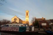
Banbury
Banbury
Banbury is a market town and civil parish on the River Cherwell in the Cherwell District of Oxfordshire. It is northwest of London, southeast of Birmingham, south of Coventry and north northwest of the county town of Oxford...
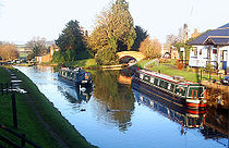
is a major stop on the route because of the large number of visitor moorings on a paved and relatively secure mooring right alongside the shopping centre in the middle of town. Banbury, unlike some towns, has attempted to treat the canal as an attraction to be encouraged, rather than an eyesore to be shunned, and an old boatyard has been incorporated into the development as Tooley's Historic Boatyard
Tooley's Boatyard
Tooley's Boatyard is a boatyard on the Oxford Canal in the centre of the town of Banbury, Oxfordshire, England.The opening of the Oxford Canal from Hawkesbury Junction to Banbury on 30 March 1778 gave the town a cheap and reliable supply of Warwickshire coal. In 1787, the Oxford Canal was extended...
. Heading south after 4 miles (6.4 km) you will approach the small hamlet, Twyford Wharf, where you can turn a narrow boat up to 60 feet (18.3 m). There are two villages, Kings Sutton and Adderbury within 30 minutes walking distance. Both offer a couple of pubs but the best is in Adderbury.
At Oxford, the canal has two connections to the River Thames
River Thames
The River Thames flows through southern England. It is the longest river entirely in England and the second longest in the United Kingdom. While it is best known because its lower reaches flow through central London, the river flows alongside several other towns and cities, including Oxford,...
. The first is three miles north of the city where Dukes Cut
Dukes Cut
Duke's Cut is a short waterway in Oxfordshire, England, which connects the Oxford Canal near Wolvercote Junction with the River Thames at King's Lock....
leads to King's Lock
King's Lock
King's Lock is a lock on the River Thames in England. It is in open country to the north of Oxford, Oxfordshire, on the southern bank of the river. The lock was one of the last pound locks built on the Thames being built by the Thames Conservancy in 1928 to replace the former flash lock.At the lock...
; the second is a few hundred yards from the city centre below Isis Lock (known to boatmen as 'Louse Lock') through Sheepwash Channel. This leads to an unusual river crossroads at the Thames called "Four Rivers" above Osney Lock
Osney Lock
Osney Lock is a lock on the River Thames in Oxfordshire, England. It is close to Oxford where the village or island of Osney is next to the river.The first lock was built of stone by Daniel Harris for the Thames Navigation Commission in 1790....
.
After 330 yards (301.8 m) below Isis Lock the Oxford Canal ends abruptly at Hythe Bridge Street
Hythe Bridge Street
Hythe Bridge Street is in the west of central Oxford, England, forming part of the A4144 road.- Location :The street links Frideswide Square and then Botley Road to the east and Worcester Street at the western end leading north, at the junction with George Street...
near to the current Hythe Bridge
Hythe Bridge
Hythe Bridge is a flat late 19th century cast iron beamed bridge on Hythe Bridge Street in the west of central Oxford, England. It spans the Castle Mill Stream, a backwater of the River Thames. Hythe Bridge forms part of the main arterial route west of Oxford...
over the Castle Mill Stream
Castle Mill Stream
Castle Mill Stream is a backwater of the River Thames in the west of Oxford, England. It is 5.5 km long.-Course:The stream leaves the main course of the Thames at the south end of Port Meadow, immediately upstream of Medley Footbridge. It then flows under the Cherwell Valley railway line and turns...
, a backwater of the River Thames
River Thames
The River Thames flows through southern England. It is the longest river entirely in England and the second longest in the United Kingdom. While it is best known because its lower reaches flow through central London, the river flows alongside several other towns and cities, including Oxford,...
that runs parallel to the Oxford Canal for its southernmost part. The canal used to continue through a bridge under Hythe Bridge Street to a turning basin and goods wharf south of Hythe Bridge Street. It then continued via a bridge under Worcester Street
Worcester Street
Worcester Street is a street in west central Oxford, England.The street runs north-south in two sections that are separated for traffic. The northern section forms part of the A4144 road. It starts opposite the eponymous Worcester College, one of the colleges of the University of Oxford, at the...
to end in a coal wharf beside New Road. In 1951 the basin and wharves were filled in and Nuffield College
Nuffield College, Oxford
Nuffield College is one of the constituent colleges of the University of Oxford in England. It is an all-graduate college and primarily a research establishment, specialising in the social sciences, particularly economics, politics and sociology. It is a research centre in the social sciences...
now stands on part of the site (see below).
Construction
The Oxford Canal was constructed in several stages over a period of more than twenty years.In 1769 an Act of Parliament
Act of Parliament
An Act of Parliament is a statute enacted as primary legislation by a national or sub-national parliament. In the Republic of Ireland the term Act of the Oireachtas is used, and in the United States the term Act of Congress is used.In Commonwealth countries, the term is used both in a narrow...
authorising the Oxford Canal was passed, having been promoted in Parliament by Sir Roger Newdigate MP
Member of Parliament
A Member of Parliament is a representative of the voters to a :parliament. In many countries with bicameral parliaments, the term applies specifically to members of the lower house, as upper houses often have a different title, such as senate, and thus also have different titles for its members,...
, who chaired the canal company. The intention was to link the industrial English Midlands
English Midlands
The Midlands, or the English Midlands, is the traditional name for the area comprising central England that broadly corresponds to the early medieval Kingdom of Mercia. It borders Southern England, Northern England, East Anglia and Wales. Its largest city is Birmingham, and it was an important...
to London
London
London is the capital city of :England and the :United Kingdom, the largest metropolitan area in the United Kingdom, and the largest urban zone in the European Union by most measures. Located on the River Thames, London has been a major settlement for two millennia, its history going back to its...
via the River Thames. Construction began shortly after near Coventry.
Surveying of the route and initial construction were originally supervised by the celebrated engineer
Engineer
An engineer is a professional practitioner of engineering, concerned with applying scientific knowledge, mathematics and ingenuity to develop solutions for technical problems. Engineers design materials, structures, machines and systems while considering the limitations imposed by practicality,...
James Brindley
James Brindley
James Brindley was an English engineer. He was born in Tunstead, Derbyshire, and lived much of his life in Leek, Staffordshire, becoming one of the most notable engineers of the 18th century.-Early life:...
, assisted by Samuel Simcock who was also Brindley's brother-in-law. Brindley died in 1772 but Simcock took over and completed the canal. By 1774 the canal had reached Napton, but the company was already running out of money.
In 1775, a second Act was passed allowing the company to raise more funds. Construction soon started again and by 1778 the canal had reached Banbury. Financial problems meant that work on the final stretch to Oxford did not begin until 1786.
The stretch of the canal from Banbury to Oxford was built as cheaply as possible. Many economy measures were used. Wherever possible, wooden lift or swing bridges were built instead of expensive brick ones. Deep locks were used wherever possible, with single gates at both ends instead of double gates.
A stretch of the River Cherwell
River Cherwell
The River Cherwell is a river which flows through the Midlands of England. It is a major tributary of the River Thames.The general course of the River Cherwell is north to south and the 'straight-line' distance from its source to the Thames is about...
at Shipton-on-Cherwell
Shipton-on-Cherwell
Shipton-on-Cherwell is a village on the River Cherwell north of Kidlington in Oxfordshire, England. The village is part of the civil parish of Shipton-on-Cherwell and Thrupp.-Manor:...
was incorporated into the canal. This reduced construction costs, but the behaviour of the river makes the canal more difficult to use. This was a false economy and its adverse effects continue to be felt to this day.
The Oxford Canal reached the outskirts of Oxford in 1789, when a coal wharf was opened at Heyfield Hutt, now the site of Hayfield Road
Hayfield Road
Hayfield Road is a residential road that runs north-south in Walton Manor, north Oxford, England.- Location :To the south, the road continues as Kingston Road, although it is block to through traffic. Aristotle Lane leads off to the west over the Oxford Canal towards Port Meadow...
. The final section into central Oxford was ceremonially opened on 1 January 1790.
Commercial use
For the next 15 years the Oxford Canal became one of the most important and profitable transport links in Britain, with most commercial traffic between London and the Midlands using the route. Its principal traffic was coalCoal
Coal is a combustible black or brownish-black sedimentary rock usually occurring in rock strata in layers or veins called coal beds or coal seams. The harder forms, such as anthracite coal, can be regarded as metamorphic rock because of later exposure to elevated temperature and pressure...
from Warwickshire. It also carried stone
Rock (geology)
In geology, rock or stone is a naturally occurring solid aggregate of minerals and/or mineraloids.The Earth's outer solid layer, the lithosphere, is made of rock. In general rocks are of three types, namely, igneous, sedimentary, and metamorphic...
, agricultural
Agriculture
Agriculture is the cultivation of animals, plants, fungi and other life forms for food, fiber, and other products used to sustain life. Agriculture was the key implement in the rise of sedentary human civilization, whereby farming of domesticated species created food surpluses that nurtured the...
products and other goods.
A much more direct route between London and the Midlands, the Grand Junction Canal
Grand Union Canal
The Grand Union Canal in England is part of the British canal system. Its main line connects London and Birmingham, stretching for 137 miles with 166 locks...
, was completed in 1805. Much of the London-bound traffic switched to this faster route, as it avoided the passage of the River Thames which still had many flash lock
Flash lock
Early locks were designed with a single gate, known as a flash lock or staunch lock. The earliest European references to what were clearly flash locks were in Roman times....
s. This greatly reduced Oxford Canal traffic south of Napton. However, the short section between Braunston and Napton became the link between the Warwick and Napton Canal and the Grand Junction Canal, making it part of the busy direct route between Birmingham and London.
The Grand Junction and Oxford canal companies were bitter rivals. When Parliament
Parliament of the United Kingdom
The Parliament of the United Kingdom of Great Britain and Northern Ireland is the supreme legislative body in the United Kingdom, British Crown dependencies and British overseas territories, located in London...
considered the Act of Parliament
Act of Parliament
An Act of Parliament is a statute enacted as primary legislation by a national or sub-national parliament. In the Republic of Ireland the term Act of the Oireachtas is used, and in the United States the term Act of Congress is used.In Commonwealth countries, the term is used both in a narrow...
for the building of the Grand Junction, the Oxford Canal successfully petitioned to make the Grand Junction pay "bar tolls" to the Oxford Canal to compensate for the loss of traffic south of Napton.
The Oxford Canal was originally built as a contour canal
Contour canal
A contour canal is an artificially-dug navigable canal which closely follows the contour line of the land it traverses in order to avoid costly engineering works such as boring a tunnel through higher ground, building an embankment over lower ground, or constructing a canal lock to change the...
, meaning that it twisted around hills to minimise vertical deviations from a level contour. However, with one eye on the developing railway network, in the 1820s the northern section of the canal between Braunston and Hawkesbury
Hawkesbury Village
Hawkesbury Village is in Warwickshire, England and is located within the Coventry–Bedworth urban area. It borders the city of Coventry at its southern point. It is situated within the Poplar Ward of the Nuneaton and Bedworth Borough Council area....
Junction was straightened out to reduce navigation time. This work reduced the distance by 14 miles, 6 furlongs. The section south of Napton was never straightened.
The northern section of the Oxford Canal between Coventry, Braunston and Napton remained an important trunk route, and remained extremely busy with freight traffic until the 1960s. The staple traffic was coal from the Warwickshire
Warwickshire
Warwickshire is a landlocked non-metropolitan county in the West Midlands region of England. The county town is Warwick, although the largest town is Nuneaton. The county is famous for being the birthplace of William Shakespeare...
and Leicestershire
Leicestershire
Leicestershire is a landlocked county in the English Midlands. It takes its name from the heavily populated City of Leicester, traditionally its administrative centre, although the City of Leicester unitary authority is today administered separately from the rest of Leicestershire...
coalfield
Coalfield
A coalfield is an area of certain uniform characteristics where coal is mined. The criteria for determining the approximate boundary of a coalfield are geographical and cultural, in addition to geological...
s to London via the Grand Union Canal. However, the southern section from Napton to Oxford became something of a backwater, and carried mostly local traffic.
Decline
William Morris, 1st Viscount Nuffield
William Richard Morris, 1st Viscount Nuffield GBE, CH , known as Sir William Morris, Bt, between 1929 and 1934 and as The Lord Nuffield between 1934 and 1938, was a British motor manufacturer and philanthropist...
(Later Viscount Nuffield) bought the canal basin at Oxford. In 1951 he filled it in and built Nuffield College
Nuffield College, Oxford
Nuffield College is one of the constituent colleges of the University of Oxford in England. It is an all-graduate college and primarily a research establishment, specialising in the social sciences, particularly economics, politics and sociology. It is a research centre in the social sciences...
on part of the former coal wharf
Wharf
A wharf or quay is a structure on the shore of a harbor where ships may dock to load and unload cargo or passengers.Such a structure includes one or more berths , and may also include piers, warehouses, or other facilities necessary for handling the ships.A wharf commonly comprises a fixed...
. Coal traffic was relocated to a canal wharf in Juxon Street, in the Jericho, Oxford
Jericho, Oxford
Jericho is a historic suburb of the English city of Oxford. It consists of the streets bounded by the Oxford Canal, Worcester College, Walton Street and Walton Well Road. Located outside the old city wall, it was originally a place for travellers to rest if they had reached the city after the...
. The goods wharf and the remainder of the coal wharf are now under a public car park that Nuffield College
Nuffield College, Oxford
Nuffield College is one of the constituent colleges of the University of Oxford in England. It is an all-graduate college and primarily a research establishment, specialising in the social sciences, particularly economics, politics and sociology. It is a research centre in the social sciences...
lets to Oxford City Council.
The Oxford Canal remained independent until it was nationalised
Nationalization
Nationalisation, also spelled nationalization, is the process of taking an industry or assets into government ownership by a national government or state. Nationalization usually refers to private assets, but may also mean assets owned by lower levels of government, such as municipalities, being...
in 1948 and became part of the Docks and Inland Waterways Executive, later the British Waterways Board.
Many Oxford Canal boatmen and women favoured horse
Horse
The horse is one of two extant subspecies of Equus ferus, or the wild horse. It is a single-hooved mammal belonging to the taxonomic family Equidae. The horse has evolved over the past 45 to 55 million years from a small multi-toed creature into the large, single-toed animal of today...
traction long after those on other canals had changed their narrowboats to diesel power. One narrowboat carrying coal on the Oxford Canal was drawn by a mule
Mule
A mule is the offspring of a male donkey and a female horse. Horses and donkeys are different species, with different numbers of chromosomes. Of the two F1 hybrids between these two species, a mule is easier to obtain than a hinny...
until 1959 and was the last horse-drawn freight narrowboat in Great Britain
Great Britain
Great Britain or Britain is an island situated to the northwest of Continental Europe. It is the ninth largest island in the world, and the largest European island, as well as the largest of the British Isles...
. This boat, Friendship, is preserved at the National Waterways Museum, Ellesmere Port
National Waterways Museum, Ellesmere Port
The Ellesmere Port site of the National Waterways Museum is situated at the northern extremity of the Shropshire Union Canal where it enters the Manchester Ship Canal at Ellesmere Port, Cheshire, England...
.
The Oxford Canal remained profitable until the mid-1950s, paying a dividend right up until nationalisation. As with most of Britain's narrow canal system, the Oxford Canal suffered from a rapid decline in freight traffic after the Second World War. By the mid-1950s very few narrowboats traded south of Napton and the southern section was at one point being threatened with closure, although the northern section (Napton to Coventry) remained well-used by commercial traffic until the 1960s.
Revival
Barbara Castle
Barbara Anne Castle, Baroness Castle of Blackburn , PC, GCOT was a British Labour Party politician....
(Minister for Transport) rejected a proposal for closure.
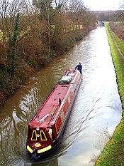
The canal is now thriving. In the summer it is one of the most crowded canals on the network.
Oxford Canal Walk
The towpath of the canal, with a 5.5-mile extension from Hawkesbury Junction to Coventry on the towpath of the Coventry Canal, forms the 132 km (82 mi) Oxford Canal Walk. The 10 mile stretch from Oxford to KirtlingtonKirtlington
Kirtlington is a village and civil parish in Oxfordshire about west of Bicester.-Archaeology:The Portway is a pre-Roman road running parallel with the River Cherwell on high ground about east of the river. It bisects Kirtlington parish and passes through the village. A short stretch of it is now...
, where the Oxfordshire Way
Oxfordshire Way
The Oxfordshire Way is a long-distance walk in Oxfordshire, England, with 6 miles in Gloucestershire and very short sections in Buckinghamshire. The path links with the Heart of England Way and the Thames Path....
meets the canal, is also part of European walking route E2
European walking route E2
The E2 European long distance path or E2 path is a 4850km long-distance footpath that runs from Galway in Ireland to France's Mediterranean coast, via Scotland, England, Netherlands, Belgium, Luxembourg and France...
. The Canal Walk is popular with geocachers with many Geocache
Geocaching
Geocaching is an outdoor sporting activity in which the participants use a Global Positioning System receiver or mobile device and other navigational techniques to hide and seek containers, called "geocaches" or "caches", anywhere in the world....
sites located alongside the canal.
See also
- Canals of Great Britain
- History of the British canal systemHistory of the British canal systemThe British canal system of water transport played a vital role in the United Kingdom's Industrial Revolution at a time when roads were only just emerging from the medieval mud and long trains of pack horses were the only means of "mass" transit by road of raw materials and finished products The...
- Eagle Ironworks, OxfordEagle Ironworks, OxfordThe Eagle Ironworks was an ironworks owned by Lucy's on the Oxford Canal in Jericho, Oxford, England. The ironworks was on Walton Well Road at the northern end of Walton Street and backed onto St Sepulchre's Cemetery...