

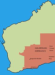
Goldfields-Esperance region of Western Australia
Encyclopedia
Regions of Western Australia
Regionalisations of Western Australia are systems by which Western Australia is divided into distinct geographic regions. The most commonly known regionalisation is the governmental division of the state into regions for economic development purposes, of which there are nine.Other regionalisations...
. It is located in the south eastern corner of Western Australia
Western Australia
Western Australia is a state of Australia, occupying the entire western third of the Australian continent. It is bounded by the Indian Ocean to the north and west, the Great Australian Bight and Indian Ocean to the south, the Northern Territory to the north-east and South Australia to the south-east...
, and comprises the local government areas
Local Government Areas of Western Australia
The Australian state of Western Australia is divided into 141 local government areas...
of Coolgardie
Shire of Coolgardie
The Shire of Coolgardie is a Local Government Area in the Goldfields-Esperance region of Western Australia, lying roughly west and south of the city of Kalgoorlie...
, Dundas
Shire of Dundas
The Shire of Dundas is a Local Government Area in the Goldfields-Esperance region of Western Australia, between Norseman and the South Australian border generally along the Eyre Highway, between 700 and 1,500 kilometres east of the state capital, Perth...
, Esperance
Shire of Esperance
The Shire of Esperance is a Local Government Area in the Goldfields-Esperance region of Western Australia, about south of the city of Kalgoorlie and about east-southeast of the state capital, Perth...
, Kalgoorlie-Boulder
City of Kalgoorlie-Boulder
The City of Kalgoorlie-Boulder is a Local Government Area in the Goldfields-Esperance region of Western Australia, about east of the state capital, Perth. The City covers an area of , and its seat of government is the town of Kalgoorlie; all but 244 of the city's population live either in...
, Laverton
Shire of Laverton
The Shire of Laverton is a Local Government Area in the Goldfields-Esperance region of Western Australia, about northeast of the city of Kalgoorlie and about east-northeast of the state capital, Perth. The Shire covers an area of , and its seat of government is the town of Laverton.-History:The...
, Leonora
Shire of Leonora
The Shire of Leonora is a Local Government Area in the Goldfields-Esperance region of Western Australia, about north of the city of Kalgoorlie and about northeast of the state capital, Perth. The Shire covers an area of , and its seat of government is the town of Leonora.-History:Leonora was...
, Menzies
Shire of Menzies
The Shire of Menzies is a Local Government Area in the Goldfields-Esperance region of Western Australia located to the north of Kalgoorlie. The Shire covers an area of , and its seat of government is the town of Menzies.-History:...
, Ngaanyatjarraku and Ravensthorpe
Shire of Ravensthorpe
The Shire of Ravensthorpe is a Local Government Area in the southern Goldfields-Esperance region of Western Australia, about halfway between the city of Albany and the town of Esperance and about southeast of the state capital, Perth. The Shire covers an area of , and its seat of government is the...
.
It also incorporates that area along the Great Australian Bight
Great Australian Bight
The Great Australian Bight is a large bight, or open bay, off the central and western portions of the southern coastline of mainland Australia.-Extent:...
to the South Australia
South Australia
South Australia is a state of Australia in the southern central part of the country. It covers some of the most arid parts of the continent; with a total land area of , it is the fourth largest of Australia's six states and two territories.South Australia shares borders with all of the mainland...
n border known as the Nullarbor.
The Goldfields-Esperance region is the largest of Western Australia's regions, with an area of 771,276 km². It is mostly a low and flat plateau of extremely ancient Precambrian
Precambrian
The Precambrian is the name which describes the large span of time in Earth's history before the current Phanerozoic Eon, and is a Supereon divided into several eons of the geologic time scale...
rocks which have been stable since long before the Paleozoic
Paleozoic
The Paleozoic era is the earliest of three geologic eras of the Phanerozoic eon, spanning from roughly...
. Because of the extreme geological stability and the absence of glaciation since the Carboniferous
Carboniferous
The Carboniferous is a geologic period and system that extends from the end of the Devonian Period, about 359.2 ± 2.5 Mya , to the beginning of the Permian Period, about 299.0 ± 0.8 Mya . The name is derived from the Latin word for coal, carbo. Carboniferous means "coal-bearing"...
, the soils are extremely infertile and generally quite saline. Consequently, the region supports the lowest stocking rates in the world: it is considered that one sheep per square mile is the maximum sustainable rate except in the small wetter area near Esperance. There are no river
River
A river is a natural watercourse, usually freshwater, flowing towards an ocean, a lake, a sea, or another river. In a few cases, a river simply flows into the ground or dries up completely before reaching another body of water. Small rivers may also be called by several other names, including...
s: any rainfall that is not absorbed by the dense rooting systems of the native flora percolates to form extremely saline
Saline water
Saline water is a general term for water that contains a significant concentration of dissolved salts . The concentration is usually expressed in parts per million of salt....
groundwater
Groundwater
Groundwater is water located beneath the ground surface in soil pore spaces and in the fractures of rock formations. A unit of rock or an unconsolidated deposit is called an aquifer when it can yield a usable quantity of water. The depth at which soil pore spaces or fractures and voids in rock...
which is very frequently too salty even for adult sheep.
The climate is mostly hot and dry. Annual rainfall is typically around 250mm (10 inches) per year and can be very variable, except in the small area near Esperance and Cape Arid National Park
Cape Arid National Park
Cape Arid National Park is a national park in Western Australia , south east of Perth. The park is situated east of Esperance and lies on shore from the eastern end of the Recherche Archipelago...
where reliable winter rainfall can give annual totals as high as 635mm (25 inches) falling mainly in the winter months. Most rainfall is produced by thunderstorm
Thunderstorm
A thunderstorm, also known as an electrical storm, a lightning storm, thundershower or simply a storm is a form of weather characterized by the presence of lightning and its acoustic effect on the Earth's atmosphere known as thunder. The meteorologically assigned cloud type associated with the...
s in spring or summer or by cloudbands from the northwest in autumn and winter, but sometimes cyclones from the Pilbara decay into rain depressions and produce heavy rainfall. Climate change
Climate change
Climate change is a significant and lasting change in the statistical distribution of weather patterns over periods ranging from decades to millions of years. It may be a change in average weather conditions or the distribution of events around that average...
has already had a major impact: in the Kalgoorlie - Eucla
Eucla, Western Australia
Eucla is the easternmost locality in Western Australia, located in the Goldfields-Esperance region of Western Australia along the Eyre Highway, approximately west of the South Australian border...
- Wiluna
Wiluna, Western Australia
Wiluna is a complex town in the Mid West region of Western Australia. It is situated on the edge of the Western Desert at the gateway to the Canning Stock Route and Gunbarrel Highway. It is the service centre of the local area for the local Aboriginal people, the pastoral industry, mining, and...
- Giles area annual rainfall has increased by over 40 percent since 1967 - probably due to lower frequencies of anticyclone
Anticyclone
An anticyclone is a weather phenomenon defined by the United States' National Weather Service's glossary as "[a] large-scale circulation of winds around a central region of high atmospheric pressure, clockwise in the Northern Hemisphere, counterclockwise in the Southern Hemisphere"...
s located over the interior of Australia instead of the adjacent oceans.
It has a population of about 59,000 people, about half of whom live in the City of Kalgoorlie-Boulder. Another quarter live in the Shire of Esperance, and the remaining shires are very sparsely populated. Nearly 10% of the region's population are of Aboriginal
Indigenous Australians
Indigenous Australians are the original inhabitants of the Australian continent and nearby islands. The Aboriginal Indigenous Australians migrated from the Indian continent around 75,000 to 100,000 years ago....
descent, which is substantially higher than the state as a whole.
The economy of the Goldfields sub-region is based on the extraction and processing of various mineral resources, primarily gold
Gold
Gold is a chemical element with the symbol Au and an atomic number of 79. Gold is a dense, soft, shiny, malleable and ductile metal. Pure gold has a bright yellow color and luster traditionally considered attractive, which it maintains without oxidizing in air or water. Chemically, gold is a...
and nickel
Nickel
Nickel is a chemical element with the chemical symbol Ni and atomic number 28. It is a silvery-white lustrous metal with a slight golden tinge. Nickel belongs to the transition metals and is hard and ductile...
. Further south near Esperance
Esperance, Western Australia
Esperance is a large town in the Goldfields-Esperance region of Western Australia, located on the Southern Ocean coastline approximately east-southeast of the state capital, Perth. The shire of Esperance is home to 9,536 people as of the 2006 census, its major industries are tourism, agriculture,...
, the economy is based on agriculture
Agriculture
Agriculture is the cultivation of animals, plants, fungi and other life forms for food, fiber, and other products used to sustain life. Agriculture was the key implement in the rise of sedentary human civilization, whereby farming of domesticated species created food surpluses that nurtured the...
and fishing
Fishing
Fishing is the activity of trying to catch wild fish. Fish are normally caught in the wild. Techniques for catching fish include hand gathering, spearing, netting, angling and trapping....
, with wheat
Wheat
Wheat is a cereal grain, originally from the Levant region of the Near East, but now cultivated worldwide. In 2007 world production of wheat was 607 million tons, making it the third most-produced cereal after maize and rice...
and barley
Barley
Barley is a major cereal grain, a member of the grass family. It serves as a major animal fodder, as a base malt for beer and certain distilled beverages, and as a component of various health foods...
widely grown; however, this requires huge inputs in fertilisers because of the sandy nature of the soils and is a major threat to the region's great plant diversity.