
City of Kalgoorlie-Boulder
Encyclopedia
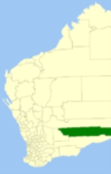
The City of Kalgoorlie-Boulder is a Local Government Area
in the Goldfields-Esperance region of Western Australia
, about 550 kilometres (342 mi) east of the state capital, Perth
. The City covers an area of 95575 square kilometres (36,902 sq mi), and its seat of government is the town of Kalgoorlie
; all but 244 of the city's population live either in Kalgoorlie or in Boulder. In terms of area, Kalgoorlie-Boulder is the largest city in Australia, and the third-largest city in the world, with a total area of 95,575km2.
in the region, a variety of local government entities sprang up around the often-temporary settlements on the Kalgoorlie goldfields. Only three persisted beyond the early 20th century:
The others were:
Local Government Areas of Western Australia
The Australian state of Western Australia is divided into 141 local government areas...
in the Goldfields-Esperance region of Western Australia
Western Australia
Western Australia is a state of Australia, occupying the entire western third of the Australian continent. It is bounded by the Indian Ocean to the north and west, the Great Australian Bight and Indian Ocean to the south, the Northern Territory to the north-east and South Australia to the south-east...
, about 550 kilometres (342 mi) east of the state capital, Perth
Perth, Western Australia
Perth is the capital and largest city of the Australian state of Western Australia and the fourth most populous city in Australia. The Perth metropolitan area has an estimated population of almost 1,700,000....
. The City covers an area of 95575 square kilometres (36,902 sq mi), and its seat of government is the town of Kalgoorlie
Kalgoorlie, Western Australia
Kalgoorlie, known as Kalgoorlie-Boulder, is a town in the Goldfields-Esperance region of Western Australia, and is located east-northeast of state capital Perth at the end of the Great Eastern Highway...
; all but 244 of the city's population live either in Kalgoorlie or in Boulder. In terms of area, Kalgoorlie-Boulder is the largest city in Australia, and the third-largest city in the world, with a total area of 95,575km2.
History
In the years immediately after discovery of goldGold
Gold is a chemical element with the symbol Au and an atomic number of 79. Gold is a dense, soft, shiny, malleable and ductile metal. Pure gold has a bright yellow color and luster traditionally considered attractive, which it maintains without oxidizing in air or water. Chemically, gold is a...
in the region, a variety of local government entities sprang up around the often-temporary settlements on the Kalgoorlie goldfields. Only three persisted beyond the early 20th century:
- Boulder Municipal Council (1897–1961) - later Town of Boulder (1961-1969)
- Kalgoorlie Roads Board (1896–1961) - later Shire of Kalgoorlie (1961-1969)
- Kalgoorlie Municipal Council (1895–1961) - later Town of Kalgoorlie (1961-1989)
- Shire of Boulder (1969-1989)
The others were:
- Broad Arrow Municipal Council (1897–1903)
- Broad Arrow Roads Board (1899–1922)
- Broad Arrow-Paddington Municipal Council (1903–1910)
- Bulong Municipal Council (1896–1909)
- Bulong Roads Board (1899–1911)
- East Coolgardie Roads Board (1895–1897)
- Kanowna Municipal Council (1896–1917)
- North East Coolgardie Roads Board (1896–1922)
- Paddington Municipal Council (1901–1903)
Major Roads in the region
- Goldfields HighwayGoldfields HighwayGoldfields Highway is a generally northwest-southeast highway in central Western Australia which links the Great Northern Highway at Meekatharra with Coolgardie-Esperance Highway south of Kalgoorlie...
- Boulder Road
- Anzac Drive
- Gatacre Drive
- Picadilly Street
- Hannan Street
- Graeme Street
- Maritana Street
- Federal Road
- Great Eastern HighwayGreat Eastern HighwayThe Great Eastern Highway is a major road between the Western Australian cities of Perth and Kalgoorlie. It is a key route for vehicles accessing the eastern wheatbelt and the eastern goldfields...
Key dates
- 1 July 1961 - Boulder and Kalgoorlie municipalities became Town Councils, and Kalgoorlie Roads Board became a Shire Council, following changes to the Local Government Act
- 1 July 1969 - Town of Boulder was amalgamated into the Shire of Kalgoorlie, which was renamed Shire of Boulder.
- 1 February 1989 - The Shire of Boulder and Town of Kalgoorlie amalgamated to form the City of Kalgoorlie-Boulder.
Wards
The City is not divided into wards and the 12 councillors sit at large. The mayor is elected by popular vote.Suburbs
- KalgoorlieKalgoorlie, Western AustraliaKalgoorlie, known as Kalgoorlie-Boulder, is a town in the Goldfields-Esperance region of Western Australia, and is located east-northeast of state capital Perth at the end of the Great Eastern Highway...
- BoulderBoulder, Western AustraliaBoulder was a town in the Western Australian goldfields east of Perth and bordering onto the town of Kalgoorlie in the Eastern Goldfields region. Until 1989 it was part of its own municipality. In 1989 the towns of Kalgoorlie and Boulder were merged to form the City of Kalgoorlie-Boulder...
- Binduli
- Broadwood
- Brown Hill
- Fimiston
- Hannans
- Ivanhoe
- Karlkurla
- Lamington
- Mullingar
- ParkestonParkeston, Western AustraliaParkeston is a suburb of the city of Kalgoorlie, Western Australia, located 3 km east of the city centre. At the 2006 census, Parkeston had a population of 69.- Railway :...
- Piccadilly
- Somerville
- South Boulder
- South Kalgoorlie
- Trafalgar
- Victory Heights
- West Kalgoorlie
- West Lamington
- Williamstown
- Yilkari
Towns
- BalagundiBalagundi, Western AustraliaBalagundi is an abandoned town in Western Australia, located 20 km east of Kalgoorlie. It is situated between Kalgoorlie and Bulong in the Goldfields-Esperance region of Western Australia....
- BalgarriBalgarri, Western AustraliaBalgarri is an abandoned town in Western Australia, located 45 km north north west of Kalgoorlie It is situated between Black Flag and Ora Banda in the Goldfields-Esperance region of Western Australia....
- BardocBardoc, Western AustraliaBardoc is an abandoned town in the Goldfields-Esperance region of Western Australia. It is situated between Kalgoorlie and Menzies along the Goldfields Highway....
- Black FlagBlack Flag, Western AustraliaBlack Flag is a ghost town in Western Australia, located 30 km north west of Kalgoorlie It is on the Black Flag to Ora Banda Road in the Goldfields-Esperance region of Western Australia....
- BooraraBoorara, Western AustraliaBoorara is a small town in the Goldfields region of Western Australia.The origin of the town's name is Aboriginal but the meaning of the word is unknown.The townsite was gazetted in 1897....
- Broad ArrowBroad Arrow, Western AustraliaBroad Arrow is a ghost town in Western Australia, located 38 km north of Kalgoorlie and 633 km east of Perth, Western Australia. It is on the Kalgoorlie to Leonora Road.-History:...
- BulongBulong, Western AustraliaBulong is an abandoned town in Western Australia located east of Perth in the Goldfields-Esperance region of Western Australia.In 1893 a group of prospectors, Hogan, Henry, Holmes, Kennedy and Turnbull, discovered gold on a lease they were granted called IOU. A surveyor named G. Hamilton was given...
- CoonanaCoonana, Western AustraliaCoonana is a small Indigenous Australian community in Western Australia located east of Perth between Kalgoorlie and Laverton in the Goldfields-Esperance region of Western Australia...
- CundeeleeCundeelee, Western AustraliaCundeelee is a small Indigenous Australian community in Western Australia located east of Perth and East of Kalgoorlie in the Goldfields-Esperance region of Western Australia...
- Emu Flat
- FeysvilleFeysville, Western AustraliaFeysville is an abandoned town in the Goldfields-Esperance region of Western Australia. It is situated between Kalgoorlie and Kambalda just off the Goldfields Highway....
- ForrestForrest, Western AustraliaForrest is a small settlement and railway station on the Trans-Australian Railway in Western Australia. At the 2006 census, Forrest had a population of 18....
- GindalbieGindalbie, Western AustraliaGindalbie is an abandoned town in the Goldfields-Esperance region of Western Australia. It is situated between Kalgoorlie and Laverton along the Donkey Rocks Road....
- Golden RidgeGolden Ridge, Western AustraliaGolden Ridge is an abandoned town in Western Australia located east of Perth just of the Mount Monger Road in the Goldfields-Esperance region of Western Australia....
- GudarraGudarra, Western AustraliaGudarra is an abandoned town in the Goldfields-Esperance region of Western Australia. It is situated between Kalgoorlie and Menzies off the Goldfields Highway....
(formerly Paddington) - KanownaKanowna, Western AustraliaKanowna is a ghost town in the Goldfields region of Western Australia. It is located about 20 km east of Kalgoorlie.After the discovery of gold in the area in 1893, the townsite was gazetted in 1894...
- KurnalpiKurnalpi, Western AustraliaKurnalpi is an abandoned town in the Goldfields-Esperance region of Western Australia. It is situated between Norseman and Laverton.In 1894 alluvial gold was discovered in the area sparking a rush to the area, a townsite being surveyed later the same year and gazetted in 1895.. The post office was...
- LakewoodLakewood, Western AustraliaLakewood is a ghost town in Western Australia, located between Kalgoorlie and Kambalda in the Goldfields-Esperance region of Western Australia....
- LoonganaLoongana, Western AustraliaLoongana is a remote siding on the transcontinental railway line in the Australian state of Western Australia. The area was formerly the site of a lime mine and processing plant...
- Mount Monger
- MulgarrieMulgarrie, Western AustraliaMulgarrie is a ghost town in Western Australia, located between Kalgoorlie and Leonora in the Goldfields-Esperance region of Western Australia....
- Ora BandaOra Banda, Western AustraliaOra Banda is a townsite, now a virtual ghost town, located north east of Kalgoorlie. According to folklore, the town name is Spanish meaning 'band of gold'.- History :...
- RawlinnaRawlinna, Western AustraliaRawlinna is a remote locality and railway siding on the Trans-Australian Railway in Western Australia. It is also the site of a small lime mine, in which the lime is extracted from the limestone that is prevalent in the area...
- WaverleyWaverley, Western AustraliaWaverley or Siberia is a ghost town located between Kalgoorlie and Leonora. It is on the Davyhurst to Ora Banda Road in the Goldfields-Esperance region of Western Australia....
- WindanyaWindanya, Western AustraliaWindanya is a ghost town located between Kalgoorlie and Leonora in the Goldfields-Esperance region of Western Australia.During the mid 1890s gold was discovered in the area and the Australasia mine was established by 1897. Following an increase in population the townsite was gazetted in 1897.The...
- ZanthusZanthus, Western AustraliaZanthus is a remote outpost on the Trans-Australian rail line approximately east of the regional city of Kalgoorlie in the Goldfields-Esperance region of Western Australia.Zanthus has a crossing loop on the line...