
Shire of Leonora
Encyclopedia
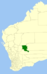
The Shire of Leonora is a Local Government Area
in the Goldfields-Esperance region of Western Australia
, about 240 kilometres (149 mi) north of the city of Kalgoorlie
and about 830 kilometres (516 mi) northeast of the state capital, Perth
. The Shire covers an area of 32189 square kilometres (12,428 sq mi), and its seat of government is the town of Leonora
.
was gazetted as a municipality with its own mayor in 1900. In 1912, the North Coolgardie Road District was dissolved and the Mount Malcolm, Kookynie and Menzies
Road Districts were formed.
Mount Malcolm absorbed the Municipality of Leonora on 1 July 1917 and became the Leonora-Mount Malcolm Road District. In 1929, a neighbouring district, Lawlers, was dissolved and split between Mount Margaret (later Laverton
) and Leonora-Mount Malcolm, which was renamed to simply Leonora a year later. On 1 July 1961, it became the Shire of Leonora under the Local Government Act 1960.
From 1979 until 2003, the shire was divided into Leonora (3), Leinster (4) and Country (2) wards.
Local Government Areas of Western Australia
The Australian state of Western Australia is divided into 141 local government areas...
in the Goldfields-Esperance region of Western Australia
Western Australia
Western Australia is a state of Australia, occupying the entire western third of the Australian continent. It is bounded by the Indian Ocean to the north and west, the Great Australian Bight and Indian Ocean to the south, the Northern Territory to the north-east and South Australia to the south-east...
, about 240 kilometres (149 mi) north of the city of Kalgoorlie
Kalgoorlie, Western Australia
Kalgoorlie, known as Kalgoorlie-Boulder, is a town in the Goldfields-Esperance region of Western Australia, and is located east-northeast of state capital Perth at the end of the Great Eastern Highway...
and about 830 kilometres (516 mi) northeast of the state capital, Perth
Perth, Western Australia
Perth is the capital and largest city of the Australian state of Western Australia and the fourth most populous city in Australia. The Perth metropolitan area has an estimated population of almost 1,700,000....
. The Shire covers an area of 32189 square kilometres (12,428 sq mi), and its seat of government is the town of Leonora
Leonora, Western Australia
Leonora is a town in the Goldfields-Esperance region of Western Australia, located northeast of the state capital, Perth, and north of the city of Kalgoorlie. At the 2006 census, Leonora had a population of 401, about a third of whom are of Aboriginal descent. The area is extremely arid, with a...
.
History
Leonora was originally part of the North Coolgardie Road District when that entity was gazetted in 1898. The town of LeonoraLeonora, Western Australia
Leonora is a town in the Goldfields-Esperance region of Western Australia, located northeast of the state capital, Perth, and north of the city of Kalgoorlie. At the 2006 census, Leonora had a population of 401, about a third of whom are of Aboriginal descent. The area is extremely arid, with a...
was gazetted as a municipality with its own mayor in 1900. In 1912, the North Coolgardie Road District was dissolved and the Mount Malcolm, Kookynie and Menzies
Shire of Menzies
The Shire of Menzies is a Local Government Area in the Goldfields-Esperance region of Western Australia located to the north of Kalgoorlie. The Shire covers an area of , and its seat of government is the town of Menzies.-History:...
Road Districts were formed.
Mount Malcolm absorbed the Municipality of Leonora on 1 July 1917 and became the Leonora-Mount Malcolm Road District. In 1929, a neighbouring district, Lawlers, was dissolved and split between Mount Margaret (later Laverton
Shire of Laverton
The Shire of Laverton is a Local Government Area in the Goldfields-Esperance region of Western Australia, about northeast of the city of Kalgoorlie and about east-northeast of the state capital, Perth. The Shire covers an area of , and its seat of government is the town of Laverton.-History:The...
) and Leonora-Mount Malcolm, which was renamed to simply Leonora a year later. On 1 July 1961, it became the Shire of Leonora under the Local Government Act 1960.
Wards
As of the 2003 election, the shire is divided into two wards:- North Ward (4 councillors)
- South Ward (5 councillors)
From 1979 until 2003, the shire was divided into Leonora (3), Leinster (4) and Country (2) wards.
Towns and localities
- LeonoraLeonora, Western AustraliaLeonora is a town in the Goldfields-Esperance region of Western Australia, located northeast of the state capital, Perth, and north of the city of Kalgoorlie. At the 2006 census, Leonora had a population of 401, about a third of whom are of Aboriginal descent. The area is extremely arid, with a...
- AgnewAgnew, Western AustraliaAgnew is a town in the Goldfields-Esperance region of Western Australia. It is located 982 km north-east of Perth and the closest populated town is Leinster....
- EulaminnaEulaminna, Western AustraliaEulaminna is an abandoned town located between Leonora and Laverton along the Old Leonora Road in the Goldfields-Esperance region of Western Australia....
- GwaliaGwalia, Western AustraliaGwalia is a former gold-mining town located 233 kilometres north of Kalgoorlie and 828 kilometres east of Perth in Western Australia's Great Victoria Desert. Today, Gwalia is essentially a ghost town, having been largely deserted since the main source of employment, the Sons of Gwalia...
- KathleenKathleen, Western AustraliaKathleen is an abandoned town located between Leinster and Wiluna along the Goldfields Highway in the Goldfields-Esperance region of Western Australia....
- KurrajongKurrajong, Western AustraliaKurrajong is an abandoned town located between Leonora and Leinster along the Old Agnew Road in the Goldfields-Esperance region of Western Australia....
- Lake Darlot
- LawlersLawlers, Western AustraliaLawlers is a ghost town in Western Australia on the Old Agnew Road located north east of Perth in the Goldfields-Esperance region of Western Australia....
- LeinsterLeinster, Western AustraliaLeinster is a town in the northern goldfields area of Western Australia. The town is located 4 km east of the Goldfields Highway, in the Shire of Leonora Local Government Area, northeast of the state capital, Perth...
- MalcolmMalcolm, Western AustraliaMalcolm is an abandoned town located between Leonora and Laverton in the Goldfields-Esperance region of Western Australia.Gold was discovered in the area in 1895 and in 1896 the local provisional committee lobbied the government to perform a survey and declare a townsite. The town boasted six...
- MertondaleMertondale, Western AustraliaMertondale is an abandoned town located between Leonora and Laverton in the Goldfields-Esperance region of Western Australia.A prospector named Fred Merton discovered Gold in the area in 1898 and the claim turned out to be an exceedingly rich find...
- Murrin MurrinMurrin Murrin, Western AustraliaMurrin Murrin is an abandoned town in Western Australia located east of Perth situated along the Old Laverton Road in between Leonora and Laverton in the Goldfields-Esperance region of Western Australia....
- Sir SamuelSir Samuel, Western AustraliaSir Samuel is an abandoned town located between Leinster and Wiluna in the Goldfields-Esperance region of Western Australia.Gold was discovered in the area in 1895. Officials lobbied for a townsite to be created in 1896 following the realisation that the area was becoming an important mining centre...
- VivienVivien, Western AustraliaVivien is an abandoned town located between Leinster and Leonora in the Goldfields-Esperance region of Western Australia.Initially the town was known as Harris which was developed in 1903 then extended in 1905 when the local progress association asked for additional lots to be surveyed...
- WoodarraWoodarra, Western AustraliaWoodarra also once known as Darlot or Lake Darlot is an abandoned town located between Leinster and Laverton in the Goldfields-Esperance region of Western Australia...
- YundaminderaYundamindera, Western AustraliaYundamindera, also once known as The Granites, is an abandoned town located between Leonora and Laverton in the Goldfields-Esperance region of Western Australia....
(known as "The Granites")