
Shire of Esperance
Encyclopedia
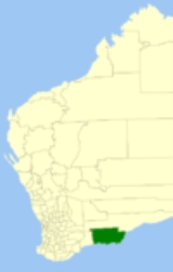
The Shire of Esperance is a Local Government Area
in the Goldfields-Esperance region of Western Australia
, about 400 kilometres (248.5 mi) south of the city of Kalgoorlie
and about 720 kilometres (447.4 mi) east-southeast of the state capital, Perth
. The Shire covers an area of 42547 square kilometres (16,427 sq mi), and its seat of government is the town of Esperance
, where about three-quarters of the Shire's population resides.
Space Station reentered Earth's atmosphere headed for Western Australia and the Indian Ocean. It broke up during reentry and much of it landed in Esperance. In turn the Shire issued a $400 fine to the American government for littering. The fine was paid in April 2009, when radio show host Scott Barley of Highway Radio raised the funds from his morning show listeners, and paid the fine on behalf of NASA
.
Local Government Areas of Western Australia
The Australian state of Western Australia is divided into 141 local government areas...
in the Goldfields-Esperance region of Western Australia
Western Australia
Western Australia is a state of Australia, occupying the entire western third of the Australian continent. It is bounded by the Indian Ocean to the north and west, the Great Australian Bight and Indian Ocean to the south, the Northern Territory to the north-east and South Australia to the south-east...
, about 400 kilometres (248.5 mi) south of the city of Kalgoorlie
Kalgoorlie, Western Australia
Kalgoorlie, known as Kalgoorlie-Boulder, is a town in the Goldfields-Esperance region of Western Australia, and is located east-northeast of state capital Perth at the end of the Great Eastern Highway...
and about 720 kilometres (447.4 mi) east-southeast of the state capital, Perth
Perth, Western Australia
Perth is the capital and largest city of the Australian state of Western Australia and the fourth most populous city in Australia. The Perth metropolitan area has an estimated population of almost 1,700,000....
. The Shire covers an area of 42547 square kilometres (16,427 sq mi), and its seat of government is the town of Esperance
Esperance, Western Australia
Esperance is a large town in the Goldfields-Esperance region of Western Australia, located on the Southern Ocean coastline approximately east-southeast of the state capital, Perth. The shire of Esperance is home to 9,536 people as of the 2006 census, its major industries are tourism, agriculture,...
, where about three-quarters of the Shire's population resides.
History
The Esperance Road District was constituted and gazetted in 1895. A municipality covering the town of Esperance, gazetted the same year, was merged into the Road District in 1908. On 1 July 1961, it became a Shire under the Local Government Act 1960. On 11 July 1979, the American SkylabSkylab
Skylab was a space station launched and operated by NASA, the space agency of the United States. Skylab orbited the Earth from 1973 to 1979, and included a workshop, a solar observatory, and other systems. It was launched unmanned by a modified Saturn V rocket, with a mass of...
Space Station reentered Earth's atmosphere headed for Western Australia and the Indian Ocean. It broke up during reentry and much of it landed in Esperance. In turn the Shire issued a $400 fine to the American government for littering. The fine was paid in April 2009, when radio show host Scott Barley of Highway Radio raised the funds from his morning show listeners, and paid the fine on behalf of NASA
NASA
The National Aeronautics and Space Administration is the agency of the United States government that is responsible for the nation's civilian space program and for aeronautics and aerospace research...
.
Wards
The shire is divided into two wards. Prior to the 2005 elections, a 13-councillor setup with North, West and East wards each with 2 councillors was in place. The shire president is elected from amongst the councillors.- Town Ward (7 councillors)
- Rural Ward (4 councillors)
Towns and localities
- EsperanceEsperance, Western AustraliaEsperance is a large town in the Goldfields-Esperance region of Western Australia, located on the Southern Ocean coastline approximately east-southeast of the state capital, Perth. The shire of Esperance is home to 9,536 people as of the 2006 census, its major industries are tourism, agriculture,...
- Bandy CreekBandy Creek, Western AustraliaBandy Creek is a north-eastern suburb of Esperance, a town in south-eastern Western Australia. Its Local Government Area is the Shire of Esperance, and it is located northeast of Esperance's central business district....
- CastletownCastletown, Western AustraliaCastletown is a north-eastern suburb of Esperance, a town in south-eastern Western Australia. Its Local Government Area is the Shire of Esperance.The suburb was gazetted in 1965.-Geography:...
- ChadwickChadwick, Western AustraliaChadwick is a northern suburb of Esperance, a town in south-eastern Western Australia. Its Local Government Area is the Shire of Esperance.Chadwick was gazetted in 1971, and at the 2006 census, Chadwick had a population of 165....
- NulsenNulsen, Western AustraliaNulsen is a western suburb of Esperance, a town in south-eastern Western Australia. Its Local Government Area is the Shire of Esperance.The suburb was gazetted in 1971, initially including the entire neighbouring suburb of Sinclair, which was separated in 1985...
- Pink LakePink Lake, Western AustraliaPink Lake is an outer western suburb of Esperance, a town in south-eastern Western Australia. Its Local Government Area is the Shire of Esperance, and it is located west-northwest of Esperance's central business district. It is named for Pink Lake, a pink-blue lake located within its boundaries....
- Sinclair
- West BeachWest Beach, Western AustraliaWest Beach is a suburb of Esperance, a town in south-eastern Western Australia, and is located south of Esperance's central business district, extending southwesterly for several kilometres along the southern coast. Its Local Government Area is the Shire of Esperance.The suburb was gazetted in...
- Windabout
- Bandy Creek
- Cape Arid National ParkCape Arid National ParkCape Arid National Park is a national park in Western Australia , south east of Perth. The park is situated east of Esperance and lies on shore from the eastern end of the Recherche Archipelago...
- Cape Le Grand National ParkCape Le Grand National ParkCape Le Grand National Park is a national park in Western Australia, south-east of Perth and east of Esperance. The park covers an area of The area is an ancient landscape has above sea level for well over 200 million years and remained unglaciated...
- CascadeCascade, Western AustraliaCascade is a small town in Western Australia located east of Perth along the South Coast between Ravensthorpe and Esperance in the Goldfields-Esperance region of Western Australia. At the 2006 census, Cascade had a population of 158....
- CondingupCondingupCondingup is a town in the Goldfields-Esperance region of Western Australia. The town is in the Shire of Esperance local government area, south east of the state capital, Perth. At the 2006 census, Condingup and the surrounding region had a population of 429....
- Coomalbidgup
- DalyupDalyup, Western AustraliaDalyup is a small town in Western Australia located about east of Perth between Munglinup and Esperance on the South Coast Highway in the Goldfields-Esperance region of Western Australia....
- GibsonGibson, Western AustraliaGibson is a small town in southeastern Western Australia, about north of Esperance. At the 2006 census, Gibson had a population of 475.-History:...
- Grass PatchGrass Patch, Western AustraliaGrass Patch is a small town in the Mallee region of Western Australia, located 79 km north of Esperance on the Coolgardie-Esperance Highway. The town was named after a nearby farm of the same name that had been settled around 1896 and was renowned for bountiful crops and good grass...
- Israelite BayIsraelite Bay, Western AustraliaIsraelite Bay is a bay and locality at Location on the south coast of Western Australia - frequently mentioned in Bureau of Meteorology weather reports as a geographical marker - it does not have a climate record....
- Neridup
- Salmon GumsSalmon Gums, Western AustraliaSalmon Gums is a small town in Western Australia located 106 km north of Esperance on the Coolgardie-Esperance Highway. The name is derived from a prominent stretch of Eucalyptus salmonophloia trees which formed a landmark in the town's early days. The town is part of the Shire of Esperance...
- ScaddanScaddan, Western AustraliaScaddan is a small town in Western Australia located east of Perth situated just off the Coolgardie-Esperance Highway between Norseman and Esperance in the Goldfields-Esperance region of Western Australia....