
Shire of Ravensthorpe
Encyclopedia
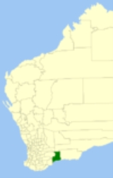
The Shire of Ravensthorpe is a Local Government Area
in the southern Goldfields-Esperance region of Western Australia
, about halfway between the city of Albany
and the town of Esperance
and about 530 kilometres (329 mi) southeast of the state capital, Perth
. The Shire covers an area of 13551 square kilometres (5,232 sq mi), and its seat of government is the town of Ravensthorpe
.
Local Government Areas of Western Australia
The Australian state of Western Australia is divided into 141 local government areas...
in the southern Goldfields-Esperance region of Western Australia
Western Australia
Western Australia is a state of Australia, occupying the entire western third of the Australian continent. It is bounded by the Indian Ocean to the north and west, the Great Australian Bight and Indian Ocean to the south, the Northern Territory to the north-east and South Australia to the south-east...
, about halfway between the city of Albany
Albany, Western Australia
Albany is a port city in the Great Southern region of Western Australia, some 418 km SE of Perth, the state capital. As of 2009, Albany's population was estimated at 33,600, making it the 6th-largest city in the state....
and the town of Esperance
Esperance, Western Australia
Esperance is a large town in the Goldfields-Esperance region of Western Australia, located on the Southern Ocean coastline approximately east-southeast of the state capital, Perth. The shire of Esperance is home to 9,536 people as of the 2006 census, its major industries are tourism, agriculture,...
and about 530 kilometres (329 mi) southeast of the state capital, Perth
Perth, Western Australia
Perth is the capital and largest city of the Australian state of Western Australia and the fourth most populous city in Australia. The Perth metropolitan area has an estimated population of almost 1,700,000....
. The Shire covers an area of 13551 square kilometres (5,232 sq mi), and its seat of government is the town of Ravensthorpe
Ravensthorpe, Western Australia
Ravensthorpe is a town 541 km south east of Perth, 40 km inland from the south coast of Western Australia. It is the seat of government of the Shire of Ravensthorpe...
.
History
The Phillips River Road District was gazetted in 1900. On 1 July 1961, it changed name to Ravensthorpe and became a Shire under the Local Government Act 1960.Wards
As of the 2003 election, the shire is divided into 3 wards:- Ravensthorpe Ward (2 councillors)
- Hopetoun Ward (2 councillors)
- Rural Ward (3 councillors)
Towns and localities
- RavensthorpeRavensthorpe, Western AustraliaRavensthorpe is a town 541 km south east of Perth, 40 km inland from the south coast of Western Australia. It is the seat of government of the Shire of Ravensthorpe...
- Desmond
- Fitzgerald RiverFitzgerald River National ParkFitzgerald River National Park is a national park in Western Australia , southeast of Perth, in the Shire of Ravensthorpe and the Shire of Jerramungup....
- HopetounHopetoun, Western AustraliaHopetoun is a town on the south coast of Western Australia in the Shire of Ravensthorpe. Located on Mary Ann Haven, Hopetoun is some south-east from capital city Perth and west of Esperance.-History:...
- JerdacuttupJerdacuttup, Western AustraliaJerdacuttup is a small town in Western Australia located east south east of Perth between Ravensthorpe and Hopetoun in the Goldfields-Esperance region of Western Australia...
- Kundip
- MunglinupMunglinup, Western AustraliaMunglinup is a small town located in the Goldfields-Esperance region of Western Australia.The town is located along the South Coast Highway between Ravensthorpe and Esperance and close to the Munglinup River....