
Shire of Dundas
Encyclopedia
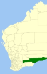
The Shire of Dundas is a Local Government Area
in the Goldfields-Esperance region of Western Australia
, between Norseman and the South Australia
n border generally along the Eyre Highway
, between 700 and 1,500 kilometres (430-930 mi) east of the state capital, Perth
. The Shire covers an area of 93179 square kilometres (35,977 sq mi) and its seat of government is the town of Norseman
.
to become the Norseman Road Board in 1918, but reestablished as Dundas in 1929. On 1 July 1961, it became the Shire Council following changes to the Local Government Act.
Local Government Areas of Western Australia
The Australian state of Western Australia is divided into 141 local government areas...
in the Goldfields-Esperance region of Western Australia
Western Australia
Western Australia is a state of Australia, occupying the entire western third of the Australian continent. It is bounded by the Indian Ocean to the north and west, the Great Australian Bight and Indian Ocean to the south, the Northern Territory to the north-east and South Australia to the south-east...
, between Norseman and the South Australia
South Australia
South Australia is a state of Australia in the southern central part of the country. It covers some of the most arid parts of the continent; with a total land area of , it is the fourth largest of Australia's six states and two territories.South Australia shares borders with all of the mainland...
n border generally along the Eyre Highway
Eyre Highway
The Eyre Highway is a highway linking Western Australia and South Australia via the Nullarbor Plain. Signed as National Highway 1/A1, it forms part of Highway 1 and the Australian National Highway network linking Perth and Adelaide. It was named after explorer Edward John Eyre, who was the first to...
, between 700 and 1,500 kilometres (430-930 mi) east of the state capital, Perth
Perth, Western Australia
Perth is the capital and largest city of the Australian state of Western Australia and the fourth most populous city in Australia. The Perth metropolitan area has an estimated population of almost 1,700,000....
. The Shire covers an area of 93179 square kilometres (35,977 sq mi) and its seat of government is the town of Norseman
Norseman, Western Australia
Norseman is a town located in the Goldfields-Esperance region of Western Australia along the Coolgardie-Esperance Highway, east of Perth and above sea level. It is also the starting point of the Eyre Highway, and the last major town in Western Australia before the South Australian border to the...
.
History
In 1895, the Dundas Road Board was gazetted. It merged with part of EsperanceShire of Esperance
The Shire of Esperance is a Local Government Area in the Goldfields-Esperance region of Western Australia, about south of the city of Kalgoorlie and about east-southeast of the state capital, Perth...
to become the Norseman Road Board in 1918, but reestablished as Dundas in 1929. On 1 July 1961, it became the Shire Council following changes to the Local Government Act.
Towns
- NorsemanNorseman, Western AustraliaNorseman is a town located in the Goldfields-Esperance region of Western Australia along the Coolgardie-Esperance Highway, east of Perth and above sea level. It is also the starting point of the Eyre Highway, and the last major town in Western Australia before the South Australian border to the...
- BalladoniaBalladonia, Western AustraliaBalladonia is a small roadhouse community located on the Eyre Highway in Western Australia, Australia. It is the first stop east of Norseman on the long journey east across the Nullarbor Plain...
- CaigunaCaiguna, Western AustraliaCaiguna is a small roadhouse community located on the Eyre Highway in Western Australia. It is the second stop east of Norseman on the long journey east across the Nullarbor Plain. Between Balladonia and Caiguna is a stretch of the highway which is one of the longest straight stretches of road in...
- CocklebiddyCocklebiddy, Western AustraliaCocklebiddy is a small roadhouse community located on the Eyre Highway in Western Australia. It is the third stop east of Norseman on the long journey east across the Nullarbor Plain. The area is noted for its underground caves and lakes.-History:...
- DundasDundas, Western AustraliaDundas is the name of an abandoned town in the Goldfields-Esperance Region of Western Australia. The town is located about east of the Esperance Branch Railway, on the western shore of Lake Dundas....
- EuclaEucla, Western AustraliaEucla is the easternmost locality in Western Australia, located in the Goldfields-Esperance region of Western Australia along the Eyre Highway, approximately west of the South Australian border...
- MaduraMadura, Western AustraliaMadura is a small roadhouse community located on the Eyre Highway in Western Australia, on the Nullarbor Plain. It is from Perth.-History:Madura was settled in 1876 as a place to breed quality cavalry horses for the British Indian Army for use in the Northwest Frontier region of India . The horses...
- MundrabillaMundrabilla, Western AustraliaMundrabilla is a small roadhouse community located on the Eyre Highway in Western Australia, on the Nullarbor Plain, west of Eucla and about north of the Great Australian Bight.-History:...
- Princess RoyalPrincess Royal, Western AustraliaPrincess Royal is an abandoned town in the Goldfields-Esperance region in Western Australia.A rich Gold reef was discovered in the area in the 1895 by a party of prospectors Chester, Peddler and Flanagan. Alluvial gold was later found in 1900 and a townsite was established to house the miners. The...