
Shire of Coolgardie
Encyclopedia
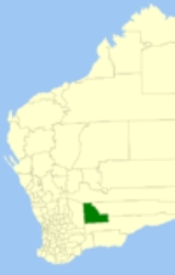
The Shire of Coolgardie is a Local Government Area
in the Goldfields-Esperance region of Western Australia
, lying roughly west and south of the city of Kalgoorlie
. The Shire covers an area of 30400 square kilometres (11,738 sq mi), and its seat of government is the town of Coolgardie
, although the twin towns of Kambalda
and Kambalda West contain two-thirds of the Shire's population.
Local Government Areas of Western Australia
The Australian state of Western Australia is divided into 141 local government areas...
in the Goldfields-Esperance region of Western Australia
Western Australia
Western Australia is a state of Australia, occupying the entire western third of the Australian continent. It is bounded by the Indian Ocean to the north and west, the Great Australian Bight and Indian Ocean to the south, the Northern Territory to the north-east and South Australia to the south-east...
, lying roughly west and south of the city of Kalgoorlie
Kalgoorlie, Western Australia
Kalgoorlie, known as Kalgoorlie-Boulder, is a town in the Goldfields-Esperance region of Western Australia, and is located east-northeast of state capital Perth at the end of the Great Eastern Highway...
. The Shire covers an area of 30400 square kilometres (11,738 sq mi), and its seat of government is the town of Coolgardie
Coolgardie, Western Australia
Coolgardie is a small town in the Australian state of Western Australia, east of the state capital, Perth. It has a population of approximately 800 people....
, although the twin towns of Kambalda
Kambalda, Western Australia
Kambalda is a small mining town about 60 kilometres from the mining city of Kalgoorlie in Western Australia, within the Goldfields. It is split into two townsites 4 kilometres apart, Kambalda East and Kambalda West; and is located on the western edge of a giant salt lake, Lake Lefroy...
and Kambalda West contain two-thirds of the Shire's population.
History
The Shire began life as two entities - Coolgardie Municipality (1894), and Coolgardie Road District (1896). As the gold rush waned in the area, the former was merged into the latter in 1921, and on 1 July 1961, it became a Shire under the Local Government Act 1960.Wards
In 2007, the ward system was abolished. Prior to this, the shire had 8 councillors and 4 wards:- Kambalda West (3 councillors)
- Kambalda (2 councillors)
- Coolgardie (2 councillors)
- Country (1 councillor)
Towns
- CoolgardieCoolgardie, Western AustraliaCoolgardie is a small town in the Australian state of Western Australia, east of the state capital, Perth. It has a population of approximately 800 people....
- Bonnie ValeBonnie Vale, Western AustraliaBonnie Vale is an abandoned goldfields townsite 14 km north of Coolgardie in Western Australia.The town was gazetted in 1897. It was apparently named after Bonnie, a prospector who picked up a 7 oz troy nugget here in May/June 1894...
- BullabullingBullabulling, Western AustraliaBullabulling is a small townsite located 526 km east of Perth, Western Australia on the Great Eastern Highway. The town was gazetted in 1898. Its central feature is the Rock Hotel roadhouse....
- BurbanksBurbanks, Western AustraliaBurbanks is an abandoned town in Western Australia located between Coolgardie and Londonderry in the Goldfields-Esperance region of Western Australia.In 1894 gold was discovered in the area and the townsite was gazetted in 1897....
(also Burbanks Gold MineBurbanks Gold MineThe Burbanks Gold Mine is a gold mine located 9 km south east of Coolgardie, Western Australia.It is currently owned by Barra Resources Limited.-History:...
) - DunnsvilleDunnsville, Western AustraliaDunnsville is an abandoned town in Western Australia located 46km north-west of Coolgardie in the Goldfields-Esperance region of Western Australia....
- HigginsvilleHigginsville, Western AustraliaHigginsville is the name of an abandoned town in the Goldfields-Esperance Region of Western Australia. At the 2006 census, Higginsville had a population of 64....
- KambaldaKambalda, Western AustraliaKambalda is a small mining town about 60 kilometres from the mining city of Kalgoorlie in Western Australia, within the Goldfields. It is split into two townsites 4 kilometres apart, Kambalda East and Kambalda West; and is located on the western edge of a giant salt lake, Lake Lefroy...
- Kambalda West
- KintoreKintore, Western AustraliaKintore is an abandoned town in Western Australia located 46km north-west of Kalgoorlie along the Coolgardie North Road in the Goldfields-Esperance region of Western Australia....
- KunanallingKunanalling, Western AustraliaKunanalling is an abandoned town in Western Australia located between Coolgardie and Balgarri along the Coolgardie North Road in the Goldfields-Esperance region of Western Australia....
- KundanaKundana, Western AustraliaKundana is an abandoned town in Western Australia located between Coolgardie and Bardoc in the Goldfields-Esperance region of Western Australia....
- KurrawangKurrawang, Western AustraliaKurrawang is an abandoned town in Western Australia located between Coolgardie and Kalgoorlie just off Great Eastern Highway in the Goldfields-Esperance region of Western Australia....
- LondonderryLondonderry, Western AustraliaLondonderry is a ghost town in Western Australia, located 14 km South West of Coolgardie in the Goldfields-Esperance region of Western Australia....
- Mount Burges
- MungariMungari, Western AustraliaMungari is a ghost town in Western Australia, located between Coolgardie and Kalgoorlie in the Goldfields-Esperance region of Western Australia....
- Spargoville
- WidgiemoolthaWidgiemooltha, Western AustraliaWidgiemooltha is an abandoned town in Western Australia located east of Perth between Kambalda and Norseman in the Goldfields-Esperance region of Western Australia....