
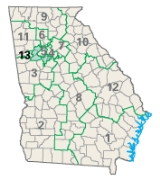
Georgia's congressional districts
Encyclopedia
After the 2000 Census, the State of Georgia
was divided into 13 Congressional Districts, increasing from 11 due to reapportionment. The state was redistricted
again in 2005, although the number of districts has remained thirteen.

Representative: Jack Kingston
(R)
Counties:
External links:
Representative: Sanford D. Bishop, Jr.
(D)
Counties:
External links:
Representative: Lynn A. Westmoreland
(R)
Counties:
External links:
Representative: Hank Johnson
(D)
Counties:
External links:
Representative: John Lewis
(D)
Counties:
External links:
Representative: Tom Price
(R)
Counties:
External links:
Representative: Rob Woodall (R)
Counties:
External links:
Representative: Austin Scott (R)
Counties:
External links:
Representative: Tom Graves
(R)
Counties:
External links:
Representative: Paul Broun
(R)
Counties:
External links:
Representative: Phil Gingrey
(R)
Counties:
External links:
Representative: John Barrow
(D)
Counties:
External links:
Representative: David Scott
(D)
Counties:
External links:
Georgia (U.S. state)
Georgia is a state located in the southeastern United States. It was established in 1732, the last of the original Thirteen Colonies. The state is named after King George II of Great Britain. Georgia was the fourth state to ratify the United States Constitution, on January 2, 1788...
was divided into 13 Congressional Districts, increasing from 11 due to reapportionment. The state was redistricted
Redistricting
Redistricting is the process of drawing United States electoral district boundaries, often in response to population changes determined by the results of the decennial census. In 36 states, the state legislature has primary responsibility for creating a redistricting plan, in many cases subject to...
again in 2005, although the number of districts has remained thirteen.
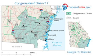
First Congressional District
- Main article:
Representative: Jack Kingston
Jack Kingston
One of the counties he represents is Wheeler County.John Heddens "Jack" Kingston is the U.S. Representative for , serving since 1993. He is a member of the Republican Party.- Early life, education and career:...
(R)
Counties:
- Appling CountyAppling County, GeorgiaAppling County is a county located in the U.S. state of Georgia. As of 2000, the population is 17,419. The 2007 Census Estimate placed the population at 17,946...
- Atkinson CountyAtkinson County, GeorgiaAtkinson County is a county located in the U.S. state of Georgia, and was formed in 1917 from parts of Coffee and Clinch counties. As of 2000, the population was 7,609. The 2007 Census Estimate placed the population at 8,223...
- Bacon CountyBacon County, GeorgiaBacon County is a county located in the U.S. state of Georgia. Bacon County is named after Augustus Bacon, a former United States Senator from Georgia. The constitutional amendment to create the county was proposed July 7, 1914, and ratified November 3, 1914. As of 2000, the population is...
- Berrien CountyBerrien County, GeorgiaBerrien County is a county located in the U.S. state of Georgia. As of 2000, the population is 16,235. The 2007 Census Estimate placed the population at 16,722. The county seat is Nashville....
- Brantley CountyBrantley County, GeorgiaBrantley County is a county located in the U.S. state of Georgia. It is part of the 'Brunswick, Georgia Metropolitan Statistical Area' which encompasses all of Brantley, Glynn, and McIntosh counties. As of 2000, the population is 14,629. The 2007 Census Estimate shows a population of 15,440...
- Bryan CountyBryan County, GeorgiaBryan County is a county located in the U.S. state of Georgia. As of 2000, the population was 23,417. The 2007 Census Estimate shows a population of 30,132...
- Camden CountyCamden County, GeorgiaCamden County is a county located in the U.S. state of Georgia. It is one of the original counties of Georgia, created February 5, 1777. As of 2000, the population was 43,664. The 2007 Census Estimate shows a population of 48,689. The county seat is Woodbine.-History:The first European to land...
- Charlton CountyCharlton County, GeorgiaCharlton County is a county located in the U.S. state of Georgia. As of 2000, the population was 10,282. The 2007 Census Estimate shows a population of 10,609. The county seat is Folkston.-History:...
- Chatham CountyChatham County, GeorgiaChatham County is a county located in the U.S. state of Georgia. The county seat and largest city is Savannah. In the official US Census of 2010, Chatham County had a total population of 265,128 . Chatham is the most populous Georgia county outside the Atlanta metropolitan area...
(see also Georgia's 12th congressional district) - Clinch CountyClinch County, GeorgiaClinch County is a county located in the U.S. state of Georgia. It was created on February 14, 1850, named in honor of Duncan Lamont Clinch. As of 2000, the population is 6,878. The 2007 Census Estimate shows a population of 6,992...
- Coffee CountyCoffee County, GeorgiaCoffee County is a county located in the U.S. state of Georgia. As of 2000, the population was 37,413. The 2007 Census Estimate shows a population of 40,085. The county seat is Douglas.-History:...
- Cook CountyCook County, GeorgiaCook County is a county located in the U.S. state of Georgia. The constitutional amendment to create the county was proposed July 30, 1918, and ratified November 5, 1918. As of 2010, the population is 17,212. The county seat is Adel...
- Echols CountyEchols County, GeorgiaEchols County is a county located in the U.S. state of Georgia. It is part of the Valdosta, Georgia Metropolitan Statistical Area. As of 2000, the population is 3,754. The 2007 Census Estimate shows a population of 4,093. The county seat is Statenville...
- Glynn CountyGlynn County, GeorgiaGlynn County is a county located in the U.S. state of Georgia. As of 2000, the population was 67,568. The 2008 Census Estimate showed a population of 75,884...
- Jeff Davis CountyJeff Davis County, GeorgiaJeff Davis County is a county located in the U.S. state of Georgia. It was created on August 18, 1905. As of 2000, the population was 12,684. It was named for the only President of the Confederate States of America, Jefferson Davis. The 2007 Census Estimate showed a population of 13,291...
- Lanier CountyLanier County, GeorgiaLanier County is a county located in the U.S. state of Georgia. It is part of the Valdosta, Georgia Metropolitan Statistical Area. As of 2009, the population was 8,423. The 2007 Census Estimate shows a population of 7,847. The county seat is Lakeland. Lakeland is Lanier County's only incorporated...
- Liberty CountyLiberty County, GeorgiaLiberty County is a county located in the U.S. state of Georgia. As of 2000, the population was 61,610. The 2007 Census Estimate shows a population of 60,503...
- Long CountyLong County, GeorgiaLong County is a county located in the U.S. state of Georgia. The constitutional amendment to create the county was proposed August 14, 1920, and ratified November 2, 1920. As of 2000, the population is 10,304. The 2007 Census Estimate shows a population of 11,300...
- Lowndes CountyLowndes County, GeorgiaLowndes County is a county located in the U.S. state of Georgia along the Florida border. It was created December 23, 1825. The 2010 Census showed a population of 109,233...
(see also Georgia's 2nd congressional district) - McIntosh CountyMcIntosh County, GeorgiaMcIntosh County is a county located in the U.S. state of Georgia. It is part of the Brunswick, Georgia, Metropolitan Statistical Area which encompasses all of McIntosh, Glynn, and Brantley counties. As of 2010, the population is 14,333. The county seat is Darien.-History:McIntosh County was split...
- Pierce CountyPierce County, GeorgiaPierce County is a county located in the U.S. state of Georgia. As of 2000, the population was 15,636. The 2007 Census Estimate shows a population of 17,881. The county seat is Blackshear....
- Telfair CountyTelfair County, GeorgiaTelfair County is a county located in the U.S. state of Georgia. As of the 2000 U.S. Census, the population was 11,794. The 2007 Census Estimate shows a population of 13,366...
- Ware CountyWare County, GeorgiaWare County is a county located in the southeast of the U.S. state of Georgia. As of 2000, the population was 35,483. The 2007 Census Estimate shows a population of 35,831 The county seat is Waycross....
- Wayne CountyWayne County, GeorgiaWayne County is a county located in the U.S. state of Georgia. As of 2000, the population was 26,565. The 2007 Census Estimate showed a population of 29,046. The county seat is Jesup.-History:...
- Wheeler CountyWheeler County, GeorgiaWheeler County is a county located in the U.S. state of Georgia. As of 2000, the population was 6,179. The 2007 Census Estimate shows a population of 6,830. The county seat is Alamo.-History:Wheeler County is named after Confederate General Joseph Wheeler...
External links:
Second Congressional District
- Main article:
Representative: Sanford D. Bishop, Jr.
Sanford Bishop
Sanford Dixon Bishop Jr. is the U.S. Representative for , serving since 1993. He is a member of the Democratic Party.The district is located in the southwestern part of the state and includes Albany, Thomasville and most of Columbus....
(D)
Counties:
- Baker CountyBaker County, GeorgiaBaker County is a county in the U.S. state of Georgia. , the population is 4,074. The 2007 Census Estimate placed the population at 3,781. The county seat is Newton.Baker County is included in the Albany, Georgia Metropolitan Statistical Area.-History:...
- Brooks CountyBrooks County, GeorgiaBrooks County is a county located in the U.S. state of Georgia. It is part of the Valdosta, Georgia Metropolitan Statistical Area. As of 2010, the population was 16,243. The county seat is Quitman...
- Calhoun CountyCalhoun County, GeorgiaCalhoun County is a county located in the U.S. state of Georgia. It was created on February 20, 1854. As of 2000, the population was 6,320. The 2007 Census Estimate shows a population of 6,098...
- Chattahoochee CountyChattahoochee County, GeorgiaChattahoochee County is a county located in the U.S. state of Georgia. It was created on February 13, 1854. The 2000 Census reported a population of 14,882. The 2009 Census Estimate shows a population of 14,402. It is part of the Columbus, Georgia-Alabama Metropolitan Statistical Area...
- Clay CountyClay County, GeorgiaClay County is a county located in the U.S. state of Georgia. As of 2000, the population was 3,357. The 2007 Census Estimate shows a population of 3,207...
- Crawford CountyCrawford County, GeorgiaCrawford County is a county located in the U.S. state of Georgia. As of 2000, the population was 12,495. The 2007 Census Estimate shows a population of 12,483. The unincorporated county seat is Knoxville.-History:...
- Crisp CountyCrisp County, GeorgiaCrisp County is a county located in the U.S. state of Georgia. It was created on August 17, 1905 and named for Charles Frederick Crisp. As of 2000, the population was 21,996. The 2007 Census Estimate shows a population of 22,125...
- Decatur CountyDecatur County, GeorgiaDecatur County is a county located in the U.S. state of Georgia. As of 2000, the population was 28,240. The 2007 Census Estimate shows a population of 28,544. The county seat is Bainbridge.-History:...
- Dooly CountyDooly County, GeorgiaDooly County is a county located in the U.S. state of Georgia. As of 2000, the population was 11,525. The 2007 Census Estimate shows a population of 11,592. The county seat is Vienna....
- Dougherty CountyDougherty County, GeorgiaDougherty County is a county located in the U.S. state of Georgia. As of 2000, the population was 96,065. The 2009 Census Estimate shows a population of 95,859. It is included in the Albany, Georgia Metropolitan Statistical Area...
- Early CountyEarly County, GeorgiaEarly County is a county located in the U.S. state of Georgia. It was created on December 15, 1818 and was named for Peter Early. As of 2010, the population is 11,008. The county seat is Blakely.-Geography:...
- Grady CountyGrady County, GeorgiaGrady County is a county located in the U.S. state of Georgia. As of 2000, the population was 23,659. The 2007 Census Estimate shows a population of 25,042. The county seat is Cairo.- History :...
- Lee CountyLee County, GeorgiaLee County is a county located in the U.S. state of Georgia. As of 2000, the population was 24,757. The 2007 Census Estimate shows a population of 33,050...
- Lowndes CountyLowndes County, GeorgiaLowndes County is a county located in the U.S. state of Georgia along the Florida border. It was created December 23, 1825. The 2010 Census showed a population of 109,233...
(see also Georgia's 1st congressional district) - Macon CountyMacon County, GeorgiaMacon County is a county located in the U.S. state of Georgia. As of the 2000 census, the population was 14,074. The 2007 Census Estimate shows a population of 13,542. The county seat is Oglethorpe.-History:...
- Marion CountyMarion County, GeorgiaMarion County is located in the U.S. state of Georgia. It was created on December 14, 1827. It is part of the Columbus, Georgia-Alabama Metropolitan Statistical Area. The 2000 Census reflected a population of 7,144. The 2009 Census Estimate shows a population of 6,995...
- Miller CountyMiller County, GeorgiaMiller County is a county located in the U.S. state of Georgia. It was created on February 26, 1856. As of 2000, the population was 6,383. The 2007 Census Estimate shows a population of 6,163. The county seat is Colquitt.-Geography:...
- Mitchell CountyMitchell County, GeorgiaMitchell County is a county located in the U.S. state of Georgia. It was created on December 21, 1857. As of 2000, the population was 23,932. The 2007 Census Estimate showed a population of 24,139. The county seat is Camilla.-Geography:...
- Muscogee CountyMuscogee County, GeorgiaMuscogee County is a county located on the central western border of the U.S. state of Georgia. It is part of the Columbus, Georgia-Alabama Metropolitan Statistical Area. As of the 2000 census, the population was 186,291. The 2009 Census Estimate shows a population of 190,414...
(see also Georgia's 3rd congressional district) - Peach CountyPeach County, GeorgiaPeach County is a county located in the U.S. state of Georgia. As of the 2000 census, the population was 23,668. The 2007 Census Estimate showed a population of 25,672. Its county seat is Fort Valley....
- Quitman CountyQuitman County, GeorgiaQuitman County is a county located in the U.S. state of Georgia. It was created on December 10, 1858 and named after General John A. Quitman, leader in the Mexican War, and once Governor of Mississippi. As of 2000, the population was 2,598. The 2007 Census Estimate shows a population of 2,666...
- Randolph CountyRandolph County, GeorgiaRandolph County is a county located in the US state of Georgia. As of 2000, the population is 7,791. The 2007 Census Estimate showed a population of 7,294. The county seat is Cuthbert.-History:Randolph County is named after Virginian John Randolph....
- Schley CountySchley County, GeorgiaSchley County is a county located in the U.S. state of Georgia. As of 2000, the county's population was 3,766. The 2007 Census Estimate shows a population of 4,123...
- Seminole CountySeminole County, GeorgiaSeminole County is a county located in the U.S. state of Georgia. As of 2000, the population was 9,369. The 2007 Census Estimate shows a population of 9,081. The county seat is Donalsonville.-History:...
- Stewart CountyStewart County, GeorgiaStewart County is a county located in the U.S. state of Georgia. It was created on December 23, 1830. The 2010 Census reflected a population of 6,058. The 2009 Census Estimate shows a population of 4,558. The county seat is Lumpkin.-History:...
- Sumter CountySumter County, GeorgiaSumter County is a county located in the southwest portion of the U.S. state of Georgia. It was created on December 26, 1831. As of 2000, the population was 33,200. The 2007 Census Estimate shows a population of 32,532...
- Talbot CountyTalbot County, GeorgiaTalbot County is a county located in the U.S. state of Georgia. The 2000 Census showed a population of 6,498. The 2009 Census Estimate showed a population of 6,355. The county seat is Talbotton.-History:...
- Taylor CountyTaylor County, GeorgiaTaylor County is a county located in the U.S. state of Georgia. As of 2000, the population was 8,815. The 2007 Census Estimate shows a population of 8,738...
- Terrell CountyTerrell County, GeorgiaTerrell County is a county located in the U.S. state of Georgia. The 2000 United States Census reported the county's population at 10,970. The 2007 Census Estimate shows a population of 10,260...
- Thomas CountyThomas County, GeorgiaThomas County is a county located in the U.S. state of Georgia. The 2010 Census showed a population of 44,720. The county seat is Thomasville.-History:...
- Webster CountyWebster County, GeorgiaWebster County is a county located in the U.S. state of Georgia. The 2000 Census reflected a population of 2,390. The 2009 Census Estimate shows a population of 2,192. The county seat is Preston.-History:...
- Worth CountyWorth County, GeorgiaWorth County is a county located in the southwestern part of the U.S. state of Georgia. As of 2000, the population was 21,967. The 2007 Census Estimate shows a population of 21,285...
(see also Georgia's 8th congressional district)
External links:
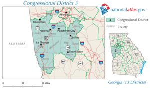
Third Congressional District
- Main article:
Representative: Lynn A. Westmoreland
Lynn Westmoreland
Lynn A. Westmoreland is the U.S. Representative for , serving since 2007. He is a member of the Republican Party. The district stretches from the far southern Atlanta suburbs to the suburbs of Columbus...
(R)
Counties:
- Carroll CountyCarroll County, GeorgiaCarroll County is a county located in the U.S. state of Georgia. As of the 2000 census, the population was 87,268. The 2007 Census Estimate shows a population of 111,954...
(see also Georgia's 11th congressional district) - Coweta CountyCoweta County, GeorgiaCoweta County is a county located in the U.S. state of Georgia. As of 2000, the population was 89,215. The 2009 Census Estimate placed the population at 131,936...
- Douglas CountyDouglas County, GeorgiaDouglas County, Georgia has been experiencing numerous natural disasters over the most recent decades. Being located in the South Eastern United States the county experiences strong storms and tornadoes often because of its location in Dixie Alley....
(see also Georgia's 13th congressional district) - Fayette CountyFayette County, GeorgiaFayette County is a county located in the U.S. state of Georgia. As of 2000, the population was 91,263. The 2007 Census Estimate shows a population of 106,144. The county seat is Fayetteville....
- Harris CountyHarris County, GeorgiaHarris County is located in the U.S. state of Georgia. It was created on December 14, 1827. As of 2000, the population was 23,695. The 2007 Census Estimate shows a population of 29,073. The county seat is Hamilton...
- Heard CountyHeard County, GeorgiaHeard County is a county located in the U.S. state of Georgia. It was created on December 22, 1830. As of 2000, the population was 11,012. The 2007 Census Estimate shows a population of 11,387...
- Henry CountyHenry County, GeorgiaHenry County is a growing suburban county located in the U.S. state of Georgia. As of the 2000 census, the population was 119,341. As of 2010, the county's population swelled to 203,922, up 70.9% from the previous census and becoming Georgia's 8th most populous county and the 10th fastest growing...
(see also Georgia's 13th congressional district) - Lamar CountyLamar County, GeorgiaLamar County is a county located in the U.S. state of Georgia. As of 2000, the population was 15,912. The 2007 Census Estimate shows a population of 16,961...
- Meriwether CountyMeriwether County, GeorgiaMeriwether County is a county located in the U.S. state of Georgia. It was created on December 14, 1827. As of 2000, the population was 22,534. The 2009 Census Estimate reflects a population of 22,783...
- Muscogee CountyMuscogee County, GeorgiaMuscogee County is a county located on the central western border of the U.S. state of Georgia. It is part of the Columbus, Georgia-Alabama Metropolitan Statistical Area. As of the 2000 census, the population was 186,291. The 2009 Census Estimate shows a population of 190,414...
(see also Georgia's 2nd congressional district) - Pike CountyPike County, GeorgiaPike County is a county located in the U.S. state of Georgia. It was created on December 9, 1822. As of 2000, the population was 13,688. The 2007 Census Estimate shows a population of 17,204...
- Rockdale CountyRockdale County, GeorgiaRockdale County is a county located in the U.S. state of Georgia. As of 2000, the population was 70,111. The 2007 Census Estimate shows a population of 82,052. Two years later, the population was 84,569. The county seat is Conyers.-Geography:...
(see also Georgia's 4th congressional district) - Spalding CountySpalding County, GeorgiaSpalding County is a county located in the U.S. state of Georgia. It was created December 20, 1851. As of 2000, the population was 58,417. The 2007 Census Estimate showed a population of 62,826...
- Troup CountyTroup County, GeorgiaTroup County is a county located in the U.S. state of Georgia. As of 2010, the population was 67,044. The county seat is LaGrange.-History:...
- Upson CountyUpson County, GeorgiaUpson County is a county located in the U.S. state of Georgia. It is a part of the Atlanta Metropolitan Area . It was created on December 15, 1824. As of 2000, the population was 27,597. The 2007 Census Estimate shows a population of 27,562...
External links:
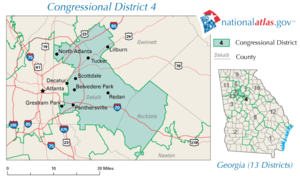
Fourth Congressional District
- Main article:
Representative: Hank Johnson
Hank Johnson
Henry C. "Hank" Johnson Jr. is the U.S. Representative for , serving since 2007. He is a member of the Democratic Party. The district is based in DeKalb County, a largely suburban county east of Atlanta. It also includes portions of Gwinnett and Rockdale counties.-Life, education and...
(D)
Counties:
- DeKalb CountyDeKalb County, GeorgiaDeKalb County is a county located in the U.S. state of Georgia. The population of the county was 691,893 at the 2010 census. Its county seat is the city of Decatur. It is bordered to the west by Fulton County and contains roughly 10% of the city of Atlanta...
(see also Georgia's 5th, 6th, and 13th congressional districts) - Gwinnett CountyGwinnett County, Georgia, Gwinnett County had a population of 805,321. The racial and ethnic composition of the population was 53.3% white , 23.6% black , 2.7% Korean, 2.6% Asian Indian, 2.0% Vietnamese, 3.3% other Asian, 0.1% Pacific Islander, 8.8% some other race and 3.1% from two or more races...
(see also Georgia's 7th congressional district) - Rockdale CountyRockdale County, GeorgiaRockdale County is a county located in the U.S. state of Georgia. As of 2000, the population was 70,111. The 2007 Census Estimate shows a population of 82,052. Two years later, the population was 84,569. The county seat is Conyers.-Geography:...
(see also Georgia's 3rd congressional district)
External links:
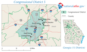
Fifth Congressional District
- Main article:
Representative: John Lewis
John Lewis (politician)
John Robert Lewis is the U.S. Representative for , serving since 1987. He was a leader in the American Civil Rights Movement and chairman of the Student Nonviolent Coordinating Committee , playing a key role in the struggle to end segregation...
(D)
Counties:
- Clayton CountyClayton County, GeorgiaClayton County is a county located in the U.S. state of Georgia. As of 2000, the population was 236,517. The 2008 Census estimate placed the population at 273,718. The county seat is Jonesboro...
(see also Georgia's 13th congressional district) - DeKalb CountyDeKalb County, GeorgiaDeKalb County is a county located in the U.S. state of Georgia. The population of the county was 691,893 at the 2010 census. Its county seat is the city of Decatur. It is bordered to the west by Fulton County and contains roughly 10% of the city of Atlanta...
(see also Georgia's 4th, 6th, and 13th congressional districts) - Fulton CountyFulton County, GeorgiaFulton County is a county located in the U.S. state of Georgia. Its county seat is Atlanta, the state capital since 1868 and the principal county of the Atlanta metropolitan area...
(see also Georgia's 6th and 13th congressional districts)
External links:
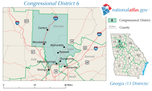
Sixth Congressional District
- Main article:
Representative: Tom Price
Tom Price (US politician)
Thomas E. Price is the U.S. Representative for , serving since 2005. He is a member of the Republican Party. The district is based in the northern suburbs of Atlanta...
(R)
Counties:
- Cherokee CountyCherokee County, GeorgiaAs of the census of 2000, there were 141,903 people, 49,495 households, and 39,200 families residing in the county. The population density was 335 people per square mile . There were 51,937 housing units at an average density of 123 per square mile...
- Cobb CountyCobb County, GeorgiaCobb County is a county located in the U.S. state of Georgia. Its county seat and largest city is Marietta, which is located in the center of the county. The county was named for Thomas Willis Cobb, who in the early 19th century was a United States representative and senator from Georgia...
(see also Georgia's 11th and 13th congressional districts) - DeKalb CountyDeKalb County, GeorgiaDeKalb County is a county located in the U.S. state of Georgia. The population of the county was 691,893 at the 2010 census. Its county seat is the city of Decatur. It is bordered to the west by Fulton County and contains roughly 10% of the city of Atlanta...
(see also Georgia's 4th, 5th, and 13th congressional districts) - Fulton CountyFulton County, GeorgiaFulton County is a county located in the U.S. state of Georgia. Its county seat is Atlanta, the state capital since 1868 and the principal county of the Atlanta metropolitan area...
(see also Georgia's 5th and 13th congressional districts)
External links:
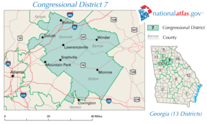
Seventh Congressional District
- Main article:
Representative: Rob Woodall (R)
Counties:
- Barrow CountyBarrow County, GeorgiaBarrow County is a county located in the U.S. state of Georgia. As of 2000, the population was 46,144. The 2007 Census Estimate placed the population at 67,139...
- Forsyth CountyForsyth County, GeorgiaForsyth County is a county located in the U.S. state of Georgia. The county seat is Cumming, Georgia. Forsyth County is a part of the Atlanta metropolitan area...
(see also Georgia's 9th congressional district) - Gwinnett CountyGwinnett County, Georgia, Gwinnett County had a population of 805,321. The racial and ethnic composition of the population was 53.3% white , 23.6% black , 2.7% Korean, 2.6% Asian Indian, 2.0% Vietnamese, 3.3% other Asian, 0.1% Pacific Islander, 8.8% some other race and 3.1% from two or more races...
(see also Georgia's 4th congressional district) - Newton CountyNewton County, GeorgiaNewton County is a county located in the U.S. state of Georgia. As of 2000, the population was 62,001. The 2010 Census showed a population of 99,958. The county seat is Covington....
(see also Georgia's 8th congressional district) - Walton CountyWalton County, GeorgiaWalton County is a county located in the U.S. state of Georgia. As of 2009, the population was 87,311. The county seat is Monroe.This county is a part of the Atlanta Metropolitan Area ....
External links:
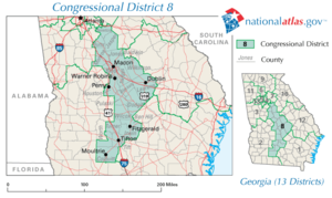
Eighth Congressional District
- Main article:
Representative: Austin Scott (R)
Counties:
- Baldwin CountyBaldwin County, GeorgiaBaldwin County is a county located in the U.S. state of Georgia. As of 2010, the population was 46,337. The county seat is Milledgeville.Baldwin County is part of the Milledgeville Micropolitan Statistical Area, which includes neighboring Hancock County....
(see also Georgia's 12th congressional district) - Ben Hill CountyBen Hill County, GeorgiaBen Hill County is a county located in the U.S. state of Georgia. The constitutional amendment to create the county was proposed July 31, 1906 and ratified November 6, 1906. As of 2000, the population was 17,484. The 2007 Census Estimate placed the population at 17,650...
- Bibb CountyBibb County, GeorgiaBibb County is a county located in the U.S. state of Georgia. As of 2000, the population was 153,887. The 2007 Census Estimate shows a population of 154,709...
- Bleckley CountyBleckley County, GeorgiaBleckley County is a county located in the U.S. state of Georgia. As of 2000, the population is 11,666. The 2007 Census Estimate shows a population of 12,306. The county seat is Cochran.- History :...
- Butts CountyButts County, GeorgiaButts County is a county located in the northern half of the U.S. state of Georgia. It was created on December 24, 1825. As of 2000, the population was 19,522. The 2007 Census Estimate showed a population of 23,759...
- Colquitt CountyColquitt County, GeorgiaColquitt County is a county located in the U.S. state of Georgia. It was created on February 25, 1856. As of 2000, the population was 42,053. The 2007 Census Estimate shows a population of 45,744. The county seat is Moultrie...
- Dodge CountyDodge County, GeorgiaDodge County is a county located in the U.S. state of Georgia. As of 2000, the population was 19,171. The 2007 Census Estimate shows a population of 20,042. The county seat is Eastman. Dodge County lies in the Historic South region of Georgia, an area that has architectural wonders and shows the...
- Houston CountyHouston County, GeorgiaHouston County is a county located in the U.S. state of Georgia. It was created on May 15, 1821, as one of five huge counties, later reduced in the formation of Bibb, Crawford, Pike, Macon and Peach counties. As of the 2000 census, the population is 110,765...
- Irwin CountyIrwin County, GeorgiaIrwin County is a county located in the U.S. state of Georgia. It was created on December 15, 1818. As of 2000, the population was 9,931. The 2007 Census Estimate shows a population of 9,934...
- Jasper CountyJasper County, GeorgiaJasper County is a county located in the U.S. state of Georgia. As of 2000, the population was 11,426. The 2007 Census Estimate shows a population of 13,660...
- Jones CountyJones County, GeorgiaJones County is a county located in the U.S. state of Georgia. It was created on December 10, 1807. As of 2010, the population was 27,740 . The county seat is Gray.-History:The county is named after U.S...
- Laurens CountyLaurens County, GeorgiaLaurens County is a county located in the U.S. state of Georgia. It was created on December 10, 1807. As of 2000, the population was 44,874. The 2007 Census Estimate shows a population of 47,520...
- Monroe CountyMonroe County, GeorgiaMonroe County is a county located in the U.S. state of Georgia. It was created on May 15, 1821. As of 2000, the population was 21,757. The 2007 Census Estimate showed a population of 25,145...
- Newton CountyNewton County, GeorgiaNewton County is a county located in the U.S. state of Georgia. As of 2000, the population was 62,001. The 2010 Census showed a population of 99,958. The county seat is Covington....
(see also Georgia's 7th congressional district) - Pulaski CountyPulaski County, GeorgiaPulaski County is a county located in the U.S. state of Georgia. As of 2000, the population was 9,588. The 2010 U.S. Census reports the population at 12,010, with a growth rate of 25.3% from 2000 to 2010, while surpassing Georgia's change of 18.3%., making it one of Georgia's fastest growing...
- Tift CountyTift County, GeorgiaTift County is a county located in the U.S. state of Georgia. As of 2000, the population was 38,407. The 2007 Census Estimate shows a population of 41,610...
- Turner CountyTurner County, GeorgiaTurner County is a county located in the U.S. state of Georgia. It was created on August 18, 1905. As of 2010, the population was 8,930. The county seat is Ashburn.-History:The County is named for Henry Gray Turner, U.S...
- Twiggs CountyTwiggs County, GeorgiaTwiggs County is a county located in the U.S. state of Georgia. It was created on December 14, 1809. As of 2000, the population was 10,590. The 2007 Census Estimate shows a population of 10,280...
- Wilcox County
- Wilkinson CountyWilkinson County, GeorgiaWilkinson County is a county located in the U.S. state of Georgia. It was created on May 11, 1803. As of 2000, the population was 10,220. The 2007 Census Estimate shows a population of 10,064...
- Worth CountyWorth County, GeorgiaWorth County is a county located in the southwestern part of the U.S. state of Georgia. As of 2000, the population was 21,967. The 2007 Census Estimate shows a population of 21,285...
(see also Georgia's 2nd congressional district)
External links:
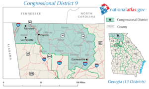
Ninth Congressional District
- Main article:
Representative: Tom Graves
Tom Graves (politician)
John Thomas "Tom" Graves, Jr. is the U.S. Representative for , serving since a special election in 2010. He is a member of the Republican Party. The district is located in the northern part of the state, including much of the north Georgia mountains...
(R)
Counties:
- Catoosa CountyCatoosa County, GeorgiaCatoosa County is a county located in the U.S. state of Georgia. It was created on December 5, 1853. As of 2000, the population was 53,282. The 2007 Census Estimate shows a population of 62,241...
- Dade CountyDade County, GeorgiaDade County is a county located in the U.S. state of Georgia. As of 2000, the population is 15,154. The 2007 Census Estimate shows a population of 16,098...
- Dawson CountyDawson County, GeorgiaDawson County is a county located in the U.S. state of Georgia. It was created on December 3, 1857 from Gilmer and Lumpkin counties. As of 2000, the population is 15,999. The 2007 Census Estimate showed a population of 21,484...
- Fannin CountyFannin County, GeorgiaFannin County is a county located in the U.S. state of Georgia. It was created on January 21, 1854. As of 2000, the population was 19,798. The 2007 Census Estimate shows a population of 22,580...
- Forsyth CountyForsyth County, GeorgiaForsyth County is a county located in the U.S. state of Georgia. The county seat is Cumming, Georgia. Forsyth County is a part of the Atlanta metropolitan area...
(see also Georgia's 7th congressional district) - Gilmer CountyGilmer County, GeorgiaGilmer County is a county located in the U.S. state of Georgia. It was created on December 3, 1832 and was named for George Rockingham Gilmer. As of 2000, the population was 23,456. The 2007 Census Estimate shows a population of 28,389...
- Gordon CountyGordon County, GeorgiaGordon County is a county located in the U.S. state of Georgia. As of 2000, the population was 44,104. The 2007 Census Estimate shows a population of 52,044. The county seat is Calhoun.- History :...
(see also Georgia's 11th congressional district) - Hall CountyHall County, GeorgiaHall County is a county located in the U.S. state of Georgia. In 2000, the population was 139,277. It is included in the Gainesville, Georgia, Metropolitan Statistical Area...
- Lumpkin CountyLumpkin County, GeorgiaLumpkin County is a county located in the U.S. state of Georgia. As of the 2010 census, the population was 29,966. Its county seat is Dahlonega.- History :...
- Murray CountyMurray County, GeorgiaMurray County is a county located in the U.S. state of Georgia. As of 2000, the population was 36,506. The 2007 Census Estimate showed a population of 40,664. The county seat is Chatsworth.It is part of the Dalton, Georgia, Metropolitan Statistical Area....
- Pickens CountyPickens County, GeorgiaPickens County is a county located in the U.S. state of Georgia. The 2000 Census showed a population of 22,983. The 2007 Census Estimate showed a population of 30,488...
- Union CountyUnion County, GeorgiaUnion County is a county located in the U.S. state of Georgia. As of 2000, the population was 17,289. The 2007 Census Estimate shows a population of 20,968. The county seat is Blairsville.Its Sole commissioner is Lamar Paris, who has served since 2001....
- Walker CountyWalker County, GeorgiaWalker County is a county located in the U.S. state of Georgia. It was created on December 18, 1833 from land formerly belonging to the Cherokee Indian Nation. As of 2000, the population was 61,053. The 2007 Census Estimate shows a population of 64,554...
- White CountyWhite County, GeorgiaWhite County is a county located in the northeast corner of the U.S. state of Georgia. It was created on December 22, 1857, from part of Habersham County. The county was named for Newton County Representative David T. White, who helped a Habersham representative successfully attain passage of an...
- Whitfield CountyWhitfield County, GeorgiaWhitfield County is a county located in the U.S. state of Georgia. It was created on December 30, 1851. The 2010 Census shows a population of 102,599. The county seat is Dalton.It is part of the Dalton, Georgia, Metropolitan Statistical Area.-Civil War:...
External links:
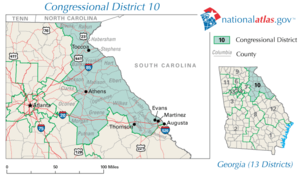
Tenth Congressional District
- Main article:
Representative: Paul Broun
Paul Broun
Paul Collins Broun, Jr. is the U.S. Representative for , serving since 2007. He is a member of the Republican Party and the Tea Party Caucus.-Early life, education and career:...
(R)
Counties:
- Banks CountyBanks County, GeorgiaBanks County is a county located in the U.S. state of Georgia. As of 2010, the population is 18,395. The county seat is Homer.-History:*The Georgia General Assembly passed legislation to create Banks County on February 1, 1859, from Franklin and Habersham Counties.*The county is named for Richard...
- Clarke CountyClarke County, GeorgiaClarke County is a county in the U.S. state of Georgia. As of the 2000 census, the population was 101,489. The 2007 Census Estimate shows a population of 114,063...
- Columbia CountyColumbia County, GeorgiaColumbia County is a county located in the US state of Georgia along the Savannah River. As of 2010 the population was 124,054 a growth of 39% from the 2000 census figure of 89,288. The de jure county seat is Appling. Appling is an unincorporated area, making Columbia one of only three counties...
- Elbert CountyElbert County, GeorgiaElbert County is a county located in the U.S. state of Georgia. It was established on December 10, 1790 and was named for Samuel Elbert. As of 2000, the population was 20,511. The 2007 Census Estimate shows a population of 20,525...
- Franklin CountyFranklin County, GeorgiaFranklin County is a county located in the U.S. state of Georgia. It became Georgia's ninth county, incorporating on February 25, 1784, and was named in honor of patriot Benjamin Franklin...
- Greene CountyGreene County, GeorgiaGreene County is a county located in the U.S. state of Georgia. It was created on February 3, 1786. As of 2000, the population is 14,406. The 2007 Census Estimate shows a population of 15,662. The county seat is Greensboro...
- Habersham CountyHabersham County, GeorgiaHabersham County is a county located in the U.S. state of Georgia. It was created on December 15, 1818, and named for Colonel Joseph Habersham. As of 2000, the population was 35,902. The 2007 Census Estimate shows a population of 42,272. Clarkesville is the county seat.Chartered in 1823, the...
- Hart CountyHart County, GeorgiaHart County is a county located in the U.S. state of Georgia. It was created December 7, 1853. As of 2000, the population was 22,997. The 2007 Census Estimate shows a population of 24,240. The county seat is Hartwell....
- Jackson CountyJackson County, GeorgiaJackson County is a county located in the U.S. state of Georgia. The population in 2000 was 41,589. Explosive growth is evident with a population of 63,544 in the 2009 Census estimates. The county seat is Jefferson.-History:...
- Lincoln CountyLincoln County, GeorgiaLincoln County is a county located in the U.S. state of Georgia, with the Savannah River forming its northeastern border. Located above the fall line, it is part of the Central Savannah River Area and a member of the CSRA Regional Development Center. The county was created on February 20, 1796. ...
- Madison CountyMadison County, GeorgiaMadison County is a county located in the U.S. state of Georgia. It was created on December 5, 1811. As of 2000, the population was 25,730. The 2007 Census Estimate shows a population of 28,012. The county seat is Danielsville....
- McDuffie CountyMcDuffie County, GeorgiaMcDuffie County is a county located in the U.S. state of Georgia. It was created on October 18, 1870. As of 2000, the population was 21,231. The 2007 Census Estimate showed a population of 21,551. The county seat is Thomson....
- Morgan CountyMorgan County, GeorgiaMorgan County is a county located in the U.S. state of Georgia. As of 2000, the population was 15,457. The 2005 Census Estimate shows a population of 17,492. The county seat is Madison, Georgia.-Geography:...
- Oconee CountyOconee County, GeorgiaOconee County is a county located in the U.S. state of Georgia. It was created on February 25, 1875. As of the 2000 census, the population was 26,225. Census estimates for 2007 show a population of 31,367...
- Oglethorpe CountyOglethorpe County, GeorgiaOglethorpe County is a county located in the U.S. state of Georgia. It is the largest county in Northeast Georgia. As of 2000, the population was 12,635. The 2007 Census Estimate showed a population of 13,963...
- Putnam CountyPutnam County, GeorgiaPutnam County is a county located in the U.S. state of Georgia. As of 2000, the population was 18,812. The 2007 Census Estimate showed a population of 21,251...
- Rabun CountyRabun County, GeorgiaRabun County is a county located in the U.S. state of Georgia. As of the 2000 census, the population was 15,050. The 2007 Census Estimate shows a population of 16,519...
- Richmond CountyRichmond County, GeorgiaRichmond County is a county located in the U.S. state of Georgia. It is one of the original counties of Georgia, created February 5, 1777. As of 2010, the population was 200,549. The 2007 Census Estimate showed a population of 199,486....
(see also Georgia's 12th congressional district) - Stephens CountyStephens County, GeorgiaStephens County is a county located in the U.S. state of Georgia. According to the 2010 Census, the population was 26,175. The 2007 Census Estimate shows a population of 25,268. The county seat is Toccoa.-History:...
- Towns CountyTowns County, GeorgiaTowns County is a county located in the U.S. state of Georgia. It was created on March 6, 1856. As of the 2000 census, the population was 9,319. The 2007 Census Estimate shows a population of 10,894. Its county seat is Hiawassee.-History:...
- Wilkes CountyWilkes County, GeorgiaWilkes County is a county located in the U.S. state of Georgia. As of 2000, the population was 10,687. The 2007 Census estimate shows a population of 10,262. The county seat is the city of Washington. Referred to as "Washington-Wilkes", the county seat and county are commonly treated as a...
External links:
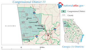
Eleventh Congressional District
- Main article:
Representative: Phil Gingrey
Phil Gingrey
John Phillip "Phil" Gingrey, is the U.S. Representative for , serving since 2003. He is a member of the Republican Party. The district is located in the northwestern suburbs of Atlanta.-Early life, education and career:...
(R)
Counties:
- Bartow CountyBartow County, GeorgiaBartow County is a county located in the U.S. state of Georgia. As of the 2010 census, the population was 100,157. According to the U.S. Census Bureau's July 1, 2009 estimate, the county's explosive growth resulted in a population of 96,217, a 26.5% increase in less than ten years...
- Carroll CountyCarroll County, GeorgiaCarroll County is a county located in the U.S. state of Georgia. As of the 2000 census, the population was 87,268. The 2007 Census Estimate shows a population of 111,954...
(see also Georgia's 3rd congressional district) - Chattooga CountyChattooga County, GeorgiaChattooga County is a county located in the U.S. state of Georgia. It was created on December 28, 1838. As of 2000, the population was 25,470. The 2007 Census Estimate shows a population of 26,797. The county seat is Summerville.-Geography:...
- Cobb CountyCobb County, GeorgiaCobb County is a county located in the U.S. state of Georgia. Its county seat and largest city is Marietta, which is located in the center of the county. The county was named for Thomas Willis Cobb, who in the early 19th century was a United States representative and senator from Georgia...
(see also Georgia's 6th and 13th congressional districts) - Floyd CountyFloyd County, GeorgiaFloyd County is a county located in the U.S. state of Georgia. As of 2000, the population was 90,565. Census estimates for 2007 show a population of 95,618...
- Gordon CountyGordon County, GeorgiaGordon County is a county located in the U.S. state of Georgia. As of 2000, the population was 44,104. The 2007 Census Estimate shows a population of 52,044. The county seat is Calhoun.- History :...
(see also Georgia's 9th congressional district) - Haralson CountyHaralson County, GeorgiaHaralson County is a county located in the U.S. state of Georgia. It was created on January 26, 1856 and was named for Hugh A. Haralson. As of 2000, the population was 25,690. The 2007 Census Estimate shows a population of 28,718...
- Paulding CountyPaulding County, GeorgiaPaulding County is a county located in the U.S. state of Georgia. As of the 2010 census, the population was 142,324. The county seat is Dallas....
- Polk CountyPolk County, GeorgiaPolk County is a county located in the U.S. state of Georgia. As of 2000, the population was 38,127. The 2007 Census Estimate shows a population of 41,460. The county seat is Cedartown.- History :...
External links:
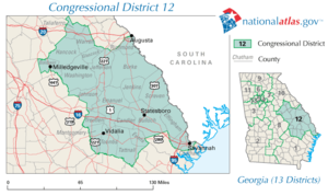
Twelfth Congressional District
- Main article:
Representative: John Barrow
John Barrow (U.S. politician)
John Jenkins Barrow is the U.S. Representative for , serving since 2005. He is a member of the Democratic Party.The district stretches along the eastern portion of the state, from Augusta to Savannah.-Early life, education and career:...
(D)
Counties:
- Baldwin CountyBaldwin County, GeorgiaBaldwin County is a county located in the U.S. state of Georgia. As of 2010, the population was 46,337. The county seat is Milledgeville.Baldwin County is part of the Milledgeville Micropolitan Statistical Area, which includes neighboring Hancock County....
(see also Georgia's 8th congressional district) - Bulloch CountyBulloch County, GeorgiaBulloch County is a county located in the U.S. state of Georgia. It was created on February 8, 1796. Bulloch County has undergone rapid growth in recent years. As of 2000, the population was 55,983. The 2009 Census Estimate showed a population of 69,213. The county seat is Statesboro.In...
- Burke CountyBurke County, GeorgiaBurke County is a county located in the U.S. state of Georgia. As of 2000, the population was 22,243. The 2007 Census Estimate showed a population of 22,754...
- Candler CountyCandler County, GeorgiaCandler County is a county located in the U.S. state of Georgia. The constitutional amendment to create the county was proposed July 14, 1914, and ratified November 3, 1914. Candler County, was named in 1914 for Allen D...
- Chatham CountyChatham County, GeorgiaChatham County is a county located in the U.S. state of Georgia. The county seat and largest city is Savannah. In the official US Census of 2010, Chatham County had a total population of 265,128 . Chatham is the most populous Georgia county outside the Atlanta metropolitan area...
(see also Georgia's 1st congressional district) - Effingham CountyEffingham County, GeorgiaEffingham County is a county located in the U.S. state of Georgia. In the United States Census of 2000, the population was 37,535. The Census Bureau's 2008 estimate estimates that this figure has grown to 52,060. The seat of Effingham County is Springfield....
- Emanuel CountyEmanuel County, GeorgiaEmanuel County is a county located in the U.S. state of Georgia. As of 2000, the population was 21,837. The 2007 Census Estimate shows a population of 22,469. The county seat is Swainsboro.-History:...
- Evans CountyEvans County, GeorgiaEvans County is a county located in the southeastern portion of the U.S. state of Georgia in an area known as the Magnolia Midlands within the Historic South region. A bill creating the county was passed in the Georgia General Assembly on August 11, 1914, and later, on November 3, 1914, an...
- Glascock CountyGlascock County, GeorgiaGlascock County is a county located in the U.S. state of Georgia. It was created on December 19, 1857. As of 2000, the population is 2,556. The 2007 Census Estimate showed a population of 2,771. The county seat is Gibson.-History:...
- Hancock CountyHancock County, Georgia-Demographics:As of the census of 2000, there were 10,076 people, 3,237 households, and 2,311 families residing in the county. The population density was 21 people per square mile . There were 4,287 housing units at an average density of 9 per square mile...
- Jefferson CountyJefferson County, GeorgiaJefferson County is a county located in the U.S. state of Georgia. It was created on February 20, 1796. As of 2000, the population was 17,266. The 2007 Census Estimate shows a population of 16,454...
- Jenkins CountyJenkins County, GeorgiaJenkins County is a county located in the U.S. state of Georgia. It was created on August 17, 1905. As of 2000, the population was 8,575. The 2007 Census Estimate shows a population of 8,595. The county seat is Millen.-Geography:...
- Johnson CountyJohnson County, GeorgiaJohnson County is a county located in the U.S. state of Georgia. As of 2000, the population was 8,560. The 2007 Census Estimate shows a population of 9,533...
- Montgomery CountyMontgomery County, GeorgiaMontgomery County is a county in the U.S. state of Georgia. As of 2000, the population was 8,270. The 2007 Census Estimate shows a population of 9,060...
- Richmond CountyRichmond County, GeorgiaRichmond County is a county located in the U.S. state of Georgia. It is one of the original counties of Georgia, created February 5, 1777. As of 2010, the population was 200,549. The 2007 Census Estimate showed a population of 199,486....
(see also Georgia's 10th congressional district) - Screven CountyScreven County, GeorgiaScreven County is a county located in the U.S. state of Georgia. As of 2000, the population was 15,374. The 2007 Census Estimate shows a population of 15,037...
- Taliaferro CountyTaliaferro County, GeorgiaTaliaferro County is a county located in the U.S. state of Georgia. As of the 2000 census, the population was 2,077, making it the least populous county east of the Mississippi River. The 2007 Census Estimate shows a population of 1,884. The county seat is Crawfordville.The spelling of the...
- Tattnall CountyTattnall County, GeorgiaTattnall County is a county located in the U.S. state of Georgia. As of 2000, the population was 22,305. The 2007 Census Estimate showed a population of 23,179...
- Toombs CountyToombs County, GeorgiaToombs County is a county located in the U.S. state of Georgia. It was created on August 18, 1905. As of 2000, the population was 26,067. The 2007 Census Estimate showed a population of 27,820. The county seat is Lyons....
- Treutlen CountyTreutlen County, GeorgiaTreutlen County is a county located in the U.S. state of Georgia. As of 2000, the population was 6,854. The 2007 Census Estimate shows a population of 6,938. The county seat is Soperton...
- Warren CountyWarren County, GeorgiaWarren County is a county located in the U.S. state of Georgia. It was created on December 19, 1793. As of 2000, the population was 6,336. The 2007 Census Estimate shows a population of 5,908...
- Washington CountyWashington County, GeorgiaWashington County is a county located in the U.S. state of Georgia. It was established on February 25, 1784. As of 2000, the population was 21,176. The 2007 Census Estimate shows a population of 20,937. The county seat is Sandersville....
External links:
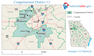
Thirteenth Congressional District
- Main article:
Representative: David Scott
David Scott (politician)
David A. Scott is the U.S. Representative for , serving since 2003. He is a member of the Democratic Party.-Early life and education:Scott was born in Aynor, South Carolina and attended high school in Daytona Beach, Florida...
(D)
Counties:
- Clayton CountyClayton County, GeorgiaClayton County is a county located in the U.S. state of Georgia. As of 2000, the population was 236,517. The 2008 Census estimate placed the population at 273,718. The county seat is Jonesboro...
(see also Georgia's 5th congressional district) - Cobb CountyCobb County, GeorgiaCobb County is a county located in the U.S. state of Georgia. Its county seat and largest city is Marietta, which is located in the center of the county. The county was named for Thomas Willis Cobb, who in the early 19th century was a United States representative and senator from Georgia...
(see also Georgia's 6th and 11th congressional districts) - DeKalb CountyDeKalb County, GeorgiaDeKalb County is a county located in the U.S. state of Georgia. The population of the county was 691,893 at the 2010 census. Its county seat is the city of Decatur. It is bordered to the west by Fulton County and contains roughly 10% of the city of Atlanta...
(see also Georgia's 4th, 5th, and 6th congressional districts) - Douglas CountyDouglas County, GeorgiaDouglas County, Georgia has been experiencing numerous natural disasters over the most recent decades. Being located in the South Eastern United States the county experiences strong storms and tornadoes often because of its location in Dixie Alley....
(see also Georgia's 3rd congressional district) - Fulton CountyFulton County, GeorgiaFulton County is a county located in the U.S. state of Georgia. Its county seat is Atlanta, the state capital since 1868 and the principal county of the Atlanta metropolitan area...
(see also Georgia's 5th and 6th congressional districts) - Henry CountyHenry County, GeorgiaHenry County is a growing suburban county located in the U.S. state of Georgia. As of the 2000 census, the population was 119,341. As of 2010, the county's population swelled to 203,922, up 70.9% from the previous census and becoming Georgia's 8th most populous county and the 10th fastest growing...
(see also Georgia's 3rd congressional district)
External links:
External links
Maps below are of congressional districts in Georgia as adopted in 2005 and effective for the 2006 elections and the 110th Congress. All maps are in PDF format.Statewide maps
- Georgia Legislative Reapportionment Services Office (LRSO) statewide map
- GeorgiaInfo statewide map (color version)
- GeorgiaInfo statewide map (b/w version)