

Telfair County, Georgia
Encyclopedia
Telfair County is a county located in the U.S. state
of Georgia
. As of the 2000 U.S. Census, the population was 11,794. The 2007 Census Estimate shows a population of 13,366. The county seat
is McRae
.
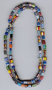 Archaeologists digging in the midst of a 2000 acres (8.1 km²) plot near McRae
, approximately a mile away from the Ocmulgee River
, located a Spanish
settlement dating back to the first half of the 16th century. The archaeologists suspected that the artifacts originated from a settlement founded by Lucas Vázquez de Ayllón in 1526. Additional research suggested that the site was one visited by the de Soto Expedition of 1541. They recovered Murano glass beads
, pottery
fragments, and iron
weapons. Some of the beads bear a chevron
pattern believed to be hallmarks of the de Soto expedition, due to the limited timespan in which they were produced. Excavations have also produced six metal objects, including three iron tools and a silver pendant.
Telfair County was established on December 10, 1807, and is named for Edward Telfair
, sixteenth governor of Georgia and member of the Continental Congress
.
of 2000, there were 11,794 people, 4,140 households, and 2,873 families residing in the county. The population density
was 27 people per square mile (10/km²). There were 5,083 housing units at an average density of 12 per square mile (4/km²). The racial makeup of the county was 59.71% White
, 38.44% Black
or African American
, 0.03% Native American
, 0.20% Asian
, 1.16% from other races
, and 0.47% from two or more races. 1.82% of the population were Hispanic
or Latino
of any race.
There were 4,140 households out of which 31.10% had children under the age of 18 living with them, 48.40% were married couples
living together, 16.70% had a female householder with no husband present, and 30.60% were non-families. 28.40% of all households were made up of individuals and 13.60% had someone living alone who was 65 years of age or older. The average household size was 2.48 and the average family size was 3.01.
In the county the population was spread out with 22.50% under the age of 18, 10.30% from 18 to 24, 30.10% from 25 to 44, 22.30% from 45 to 64, and 14.90% who were 65 years of age or older. The median age was 37 years. For every 100 females there were 110.90 males. For every 100 females age 18 and over, there were 113.20 males.
The median income for a household in the county was $26,097, and the median income for a family was $32,513. Males had a median income of $26,444 versus $19,970 for females. The per capita income
for the county was $14,197. About 17.30% of families and 21.20% of the population were below the poverty line, including 26.40% of those under age 18 and 23.70% of those age 65 or over.
U.S. state
A U.S. state is any one of the 50 federated states of the United States of America that share sovereignty with the federal government. Because of this shared sovereignty, an American is a citizen both of the federal entity and of his or her state of domicile. Four states use the official title of...
of Georgia
Georgia (U.S. state)
Georgia is a state located in the southeastern United States. It was established in 1732, the last of the original Thirteen Colonies. The state is named after King George II of Great Britain. Georgia was the fourth state to ratify the United States Constitution, on January 2, 1788...
. As of the 2000 U.S. Census, the population was 11,794. The 2007 Census Estimate shows a population of 13,366. The county seat
County seat
A county seat is an administrative center, or seat of government, for a county or civil parish. The term is primarily used in the United States....
is McRae
McRae, Georgia
McRae is a town in Telfair County, Georgia, United States. Based on the 2000 census, the town has a total population of 2,682. Between 1990 and 2000, the town experienced a population decrease of 10.8%, compared to the state growth during this period of 26.4%. The town is the county seat of...
.
History
McRae, Georgia
McRae is a town in Telfair County, Georgia, United States. Based on the 2000 census, the town has a total population of 2,682. Between 1990 and 2000, the town experienced a population decrease of 10.8%, compared to the state growth during this period of 26.4%. The town is the county seat of...
, approximately a mile away from the Ocmulgee River
Ocmulgee River
The Ocmulgee River is a tributary of the Altamaha River, approximately 255 mi long, in the U.S. state of Georgia...
, located a Spanish
Spanish Empire
The Spanish Empire comprised territories and colonies administered directly by Spain in Europe, in America, Africa, Asia and Oceania. It originated during the Age of Exploration and was therefore one of the first global empires. At the time of Habsburgs, Spain reached the peak of its world power....
settlement dating back to the first half of the 16th century. The archaeologists suspected that the artifacts originated from a settlement founded by Lucas Vázquez de Ayllón in 1526. Additional research suggested that the site was one visited by the de Soto Expedition of 1541. They recovered Murano glass beads
Murano beads
Murano beads are intricate glass beads influenced by Venetian glass artists.Since 1291, the Murano glassmakers have refined technologies such as crystalline glass, enamelled glass , glass with threads of gold , multicoloured glass , milk glass and imitation gemstones made of glass producing beads...
, pottery
Pottery
Pottery is the material from which the potteryware is made, of which major types include earthenware, stoneware and porcelain. The place where such wares are made is also called a pottery . Pottery also refers to the art or craft of the potter or the manufacture of pottery...
fragments, and iron
Iron
Iron is a chemical element with the symbol Fe and atomic number 26. It is a metal in the first transition series. It is the most common element forming the planet Earth as a whole, forming much of Earth's outer and inner core. It is the fourth most common element in the Earth's crust...
weapons. Some of the beads bear a chevron
Chevron bead
Chevron beads are special glass beads, the first specimens of this type were created by glass bead makers in Venice and Murano, Italy, towards the end of the 14th century. They may also be referred to as Rosetta, or star beads...
pattern believed to be hallmarks of the de Soto expedition, due to the limited timespan in which they were produced. Excavations have also produced six metal objects, including three iron tools and a silver pendant.
Telfair County was established on December 10, 1807, and is named for Edward Telfair
Edward Telfair
Edward Telfair was the Governor of the state of Georgia in 1786, and from 1790 through 1793. He was a member of the Continental Congress, and a signer of the Articles of Confederation.-Early Life:...
, sixteenth governor of Georgia and member of the Continental Congress
Continental Congress
The Continental Congress was a convention of delegates called together from the Thirteen Colonies that became the governing body of the United States during the American Revolution....
.
Geography
According to the 2000 census, the county has a total area of 444.08 square miles (1,150.2 km²), of which 441.09 square miles (1,142.4 km²) (or 99.33%) is land and 2.99 square miles (7.7 km²) (or 0.67%) is water. The county contains at least 50 artesian wells.Major highways
 U.S. Highway 23
 U.S. Highway 280
 U.S. Highway 319
 U.S. Highway 441
 U.S. Highway 341
 Georgia State Route 132
 Georgia State Route 165
- Georgia State Route 117
- Georgia State Route 149
- Georgia State Route 165
- Georgia State Route 134
- Georgia State Route 30Georgia State Route 30State Route 30 is an east–west route located in the U.S. state of Georgia. The route runs from SR 41 in Marion County east to SR 25 in Port Wentworth. The route is cosigned with U.S. Route 280 for a majority of its length....
- Georgia State Route 27Georgia State Route 27State Route 27 is a west–east state route located in the southern part of the U.S. state of Georgia. The route travels from SR 39 east of Georgetown to U.S. 17/SR 25 in Brunswick.-Route description:...
- Georgia State Route 31Georgia State Route 31State Route 31 is a north–south state route located in the central and southern parts of the U.S. state of Georgia. The route travels from Florida State Road 145 at the Florida state line south of Clyattville to SR 15/SR 57/SR 78 in Wrightsville....
- Georgia State Route 132
Adjacent counties
- Wheeler CountyWheeler County, GeorgiaWheeler County is a county located in the U.S. state of Georgia. As of 2000, the population was 6,179. The 2007 Census Estimate shows a population of 6,830. The county seat is Alamo.-History:Wheeler County is named after Confederate General Joseph Wheeler...
(northeast) - Jeff Davis CountyJeff Davis County, GeorgiaJeff Davis County is a county located in the U.S. state of Georgia. It was created on August 18, 1905. As of 2000, the population was 12,684. It was named for the only President of the Confederate States of America, Jefferson Davis. The 2007 Census Estimate showed a population of 13,291...
(southeast) - Coffee CountyCoffee County, GeorgiaCoffee County is a county located in the U.S. state of Georgia. As of 2000, the population was 37,413. The 2007 Census Estimate shows a population of 40,085. The county seat is Douglas.-History:...
(south) - Ben Hill CountyBen Hill County, GeorgiaBen Hill County is a county located in the U.S. state of Georgia. The constitutional amendment to create the county was proposed July 31, 1906 and ratified November 6, 1906. As of 2000, the population was 17,484. The 2007 Census Estimate placed the population at 17,650...
(southwest) - Wilcox County (west)
- Dodge CountyDodge County, GeorgiaDodge County is a county located in the U.S. state of Georgia. As of 2000, the population was 19,171. The 2007 Census Estimate shows a population of 20,042. The county seat is Eastman. Dodge County lies in the Historic South region of Georgia, an area that has architectural wonders and shows the...
(northwest)
Demographics
As of the censusCensus
A census is the procedure of systematically acquiring and recording information about the members of a given population. It is a regularly occurring and official count of a particular population. The term is used mostly in connection with national population and housing censuses; other common...
of 2000, there were 11,794 people, 4,140 households, and 2,873 families residing in the county. The population density
Population density
Population density is a measurement of population per unit area or unit volume. It is frequently applied to living organisms, and particularly to humans...
was 27 people per square mile (10/km²). There were 5,083 housing units at an average density of 12 per square mile (4/km²). The racial makeup of the county was 59.71% White
Race (United States Census)
Race and ethnicity in the United States Census, as defined by the Federal Office of Management and Budget and the United States Census Bureau, are self-identification data items in which residents choose the race or races with which they most closely identify, and indicate whether or not they are...
, 38.44% Black
Race (United States Census)
Race and ethnicity in the United States Census, as defined by the Federal Office of Management and Budget and the United States Census Bureau, are self-identification data items in which residents choose the race or races with which they most closely identify, and indicate whether or not they are...
or African American
Race (United States Census)
Race and ethnicity in the United States Census, as defined by the Federal Office of Management and Budget and the United States Census Bureau, are self-identification data items in which residents choose the race or races with which they most closely identify, and indicate whether or not they are...
, 0.03% Native American
Race (United States Census)
Race and ethnicity in the United States Census, as defined by the Federal Office of Management and Budget and the United States Census Bureau, are self-identification data items in which residents choose the race or races with which they most closely identify, and indicate whether or not they are...
, 0.20% Asian
Race (United States Census)
Race and ethnicity in the United States Census, as defined by the Federal Office of Management and Budget and the United States Census Bureau, are self-identification data items in which residents choose the race or races with which they most closely identify, and indicate whether or not they are...
, 1.16% from other races
Race (United States Census)
Race and ethnicity in the United States Census, as defined by the Federal Office of Management and Budget and the United States Census Bureau, are self-identification data items in which residents choose the race or races with which they most closely identify, and indicate whether or not they are...
, and 0.47% from two or more races. 1.82% of the population were Hispanic
Race (United States Census)
Race and ethnicity in the United States Census, as defined by the Federal Office of Management and Budget and the United States Census Bureau, are self-identification data items in which residents choose the race or races with which they most closely identify, and indicate whether or not they are...
or Latino
Race (United States Census)
Race and ethnicity in the United States Census, as defined by the Federal Office of Management and Budget and the United States Census Bureau, are self-identification data items in which residents choose the race or races with which they most closely identify, and indicate whether or not they are...
of any race.
There were 4,140 households out of which 31.10% had children under the age of 18 living with them, 48.40% were married couples
Marriage
Marriage is a social union or legal contract between people that creates kinship. It is an institution in which interpersonal relationships, usually intimate and sexual, are acknowledged in a variety of ways, depending on the culture or subculture in which it is found...
living together, 16.70% had a female householder with no husband present, and 30.60% were non-families. 28.40% of all households were made up of individuals and 13.60% had someone living alone who was 65 years of age or older. The average household size was 2.48 and the average family size was 3.01.
In the county the population was spread out with 22.50% under the age of 18, 10.30% from 18 to 24, 30.10% from 25 to 44, 22.30% from 45 to 64, and 14.90% who were 65 years of age or older. The median age was 37 years. For every 100 females there were 110.90 males. For every 100 females age 18 and over, there were 113.20 males.
The median income for a household in the county was $26,097, and the median income for a family was $32,513. Males had a median income of $26,444 versus $19,970 for females. The per capita income
Per capita income
Per capita income or income per person is a measure of mean income within an economic aggregate, such as a country or city. It is calculated by taking a measure of all sources of income in the aggregate and dividing it by the total population...
for the county was $14,197. About 17.30% of families and 21.20% of the population were below the poverty line, including 26.40% of those under age 18 and 23.70% of those age 65 or over.
Cities and towns
- HelenaHelena, GeorgiaHelena is a city in Telfair and Wheeler counties in the U.S. state of Georgia. The population was 2,307 at the 2000 census.-Geography:Helena is located at ....
- JacksonvilleJacksonville, GeorgiaJacksonville is a town in Telfair County, Georgia, United States. The population was 118 at the 2000 census.-Geography:Jacksonville is located at ....
- Lumber CityLumber City, GeorgiaLumber City is a city located in Telfair County, Georgia. As of the 2000 census, the city had a total population of 1,247.- Geography :Lumber City is located at 31°55'48" North, 82°41'1" West ....
- McRaeMcRae, GeorgiaMcRae is a town in Telfair County, Georgia, United States. Based on the 2000 census, the town has a total population of 2,682. Between 1990 and 2000, the town experienced a population decrease of 10.8%, compared to the state growth during this period of 26.4%. The town is the county seat of...
- ScotlandScotland, GeorgiaScotland is a city in Telfair and Wheeler counties in the U.S. state of Georgia. As of the 2000 census, the city population was 300.-Geography:Scotland is located at ....
- MilanMilan, GeorgiaMilan is a town in Dodge and Telfair Counties in the U.S. state of Georgia. The population was 1,012 at the 2000 census.-Geography:Milan is located at ....