

Tattnall County, Georgia
Encyclopedia
Tattnall County is a county located in the U.S. state
of Georgia
. As of 2000, the population was 22,305. The 2007 Census Estimate showed a population of 23,179. The county seat
is Reidsville
.
of 2000, there were 22,305 people, 7,057 households, and 4,876 families residing in the county. The population density
was 46 people per square mile (18/km²). There were 8,578 housing units at an average density of 18 per square mile (7/km²). The racial makeup of the county was 60.51% White
, 31.43% Black
or African American
, 0.14% Native American
, 0.29% Asian
, 0.08% Pacific Islander
, 6.64% from other races
, and 0.92% from two or more races. 8.44% of the population were Hispanic
or Latino
of any race.
There were 7,057 households out of which 33.00% had children under the age of 18 living with them, 51.10% were married couples
living together, 13.40% had a female householder with no husband present, and 30.90% were non-families. 26.70% of all households were made up of individuals and 11.90% had someone living alone who was 65 years of age or older. The average household size was 2.60 and the average family size was 3.12.
In the county the population was spread out with 22.90% under the age of 18, 11.20% from 18 to 24, 34.60% from 25 to 44, 20.00% from 45 to 64, and 11.20% who were 65 years of age or older. The median age was 34 years. For every 100 females there were 136.10 males. For every 100 females age 18 and over, there were 146.30 males.
The median income for a household in the county was $28,664, and the median income for a family was $35,951. Males had a median income of $28,994 versus $19,984 for females. The per capita income
for the county was $13,439. About 18.60% of families and 23.90% of the population were below the poverty line, including 32.90% of those under age 18 and 20.20% of those age 65 or over.
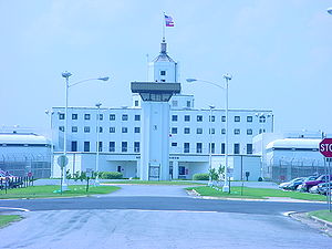 The Georgia Department of Corrections operates the Georgia State Prison
in unincorporated
Tattnall County, near Reidsville
.
U.S. state
A U.S. state is any one of the 50 federated states of the United States of America that share sovereignty with the federal government. Because of this shared sovereignty, an American is a citizen both of the federal entity and of his or her state of domicile. Four states use the official title of...
of Georgia
Georgia (U.S. state)
Georgia is a state located in the southeastern United States. It was established in 1732, the last of the original Thirteen Colonies. The state is named after King George II of Great Britain. Georgia was the fourth state to ratify the United States Constitution, on January 2, 1788...
. As of 2000, the population was 22,305. The 2007 Census Estimate showed a population of 23,179. The county seat
County seat
A county seat is an administrative center, or seat of government, for a county or civil parish. The term is primarily used in the United States....
is Reidsville
Reidsville, Georgia
Reidsville is a city in Tattnall County, Georgia, United States. The population was 2,235 at the 2000 census. The city is the county seat of Tattnall County...
.
Geography
According to the 2000 census, the county has a total area of 488.22 square miles (1,264.5 km²), of which 483.69 square miles (1,252.8 km²) (or 99.07%) is land and 4.53 square miles (11.7 km²) (or 0.93%) is water.Major highways
{
 U.S. Highway 25/U.S. Highway 301
 U.S. Highway 280
 Georgia State Route 23Georgia State Route 23State Route 23 is a state route located in the eastern part of the U.S. state of Georgia. The route travels from the Florida state line in southern Charlton County north to State Route 56 north of Waynesboro.-Route description:...
 Georgia State Route 56Georgia State Route 56State Route 56 is a north–south state route located in the eastern part of the U.S. state of Georgia. The route travels from U.S. Route 280/State Route 30 in Reidsville to U.S. Route 25/State Route 121 in Augusta.-Route description:...
 Georgia State Route 57Georgia State Route 57State Route 57 is a west–east state route located in the central part of the U.S. state of Georgia. The route travels from U.S. Route 80/State Route 19 east of Macon east, then southeast, to Interstate 95 north of Darien.-Route description:...
 Georgia State Route 86
 Georgia State Route 121
 Georgia State Route 144Georgia State Route 144State Route 144 is an east–west highway in southern Georgia, USA. It begins near the Atlantic coast southeast of Keller in south Bryan County, where a spur leads to Fort McAllister Historic Park...
 Georgia State Route 169
Adjacent counties
- Candler CountyCandler County, GeorgiaCandler County is a county located in the U.S. state of Georgia. The constitutional amendment to create the county was proposed July 14, 1914, and ratified November 3, 1914. Candler County, was named in 1914 for Allen D...
(north) - Evans CountyEvans County, GeorgiaEvans County is a county located in the southeastern portion of the U.S. state of Georgia in an area known as the Magnolia Midlands within the Historic South region. A bill creating the county was passed in the Georgia General Assembly on August 11, 1914, and later, on November 3, 1914, an...
(northeast) - Liberty CountyLiberty County, GeorgiaLiberty County is a county located in the U.S. state of Georgia. As of 2000, the population was 61,610. The 2007 Census Estimate shows a population of 60,503...
(east-southeast) - Long CountyLong County, GeorgiaLong County is a county located in the U.S. state of Georgia. The constitutional amendment to create the county was proposed August 14, 1920, and ratified November 2, 1920. As of 2000, the population is 10,304. The 2007 Census Estimate shows a population of 11,300...
(southeast) - Wayne CountyWayne County, GeorgiaWayne County is a county located in the U.S. state of Georgia. As of 2000, the population was 26,565. The 2007 Census Estimate showed a population of 29,046. The county seat is Jesup.-History:...
(south) - Appling CountyAppling County, GeorgiaAppling County is a county located in the U.S. state of Georgia. As of 2000, the population is 17,419. The 2007 Census Estimate placed the population at 17,946...
(southwest) - Toombs CountyToombs County, GeorgiaToombs County is a county located in the U.S. state of Georgia. It was created on August 18, 1905. As of 2000, the population was 26,067. The 2007 Census Estimate showed a population of 27,820. The county seat is Lyons....
(west)
Demographics
As of the censusCensus
A census is the procedure of systematically acquiring and recording information about the members of a given population. It is a regularly occurring and official count of a particular population. The term is used mostly in connection with national population and housing censuses; other common...
of 2000, there were 22,305 people, 7,057 households, and 4,876 families residing in the county. The population density
Population density
Population density is a measurement of population per unit area or unit volume. It is frequently applied to living organisms, and particularly to humans...
was 46 people per square mile (18/km²). There were 8,578 housing units at an average density of 18 per square mile (7/km²). The racial makeup of the county was 60.51% White
Race (United States Census)
Race and ethnicity in the United States Census, as defined by the Federal Office of Management and Budget and the United States Census Bureau, are self-identification data items in which residents choose the race or races with which they most closely identify, and indicate whether or not they are...
, 31.43% Black
Race (United States Census)
Race and ethnicity in the United States Census, as defined by the Federal Office of Management and Budget and the United States Census Bureau, are self-identification data items in which residents choose the race or races with which they most closely identify, and indicate whether or not they are...
or African American
Race (United States Census)
Race and ethnicity in the United States Census, as defined by the Federal Office of Management and Budget and the United States Census Bureau, are self-identification data items in which residents choose the race or races with which they most closely identify, and indicate whether or not they are...
, 0.14% Native American
Race (United States Census)
Race and ethnicity in the United States Census, as defined by the Federal Office of Management and Budget and the United States Census Bureau, are self-identification data items in which residents choose the race or races with which they most closely identify, and indicate whether or not they are...
, 0.29% Asian
Race (United States Census)
Race and ethnicity in the United States Census, as defined by the Federal Office of Management and Budget and the United States Census Bureau, are self-identification data items in which residents choose the race or races with which they most closely identify, and indicate whether or not they are...
, 0.08% Pacific Islander
Race (United States Census)
Race and ethnicity in the United States Census, as defined by the Federal Office of Management and Budget and the United States Census Bureau, are self-identification data items in which residents choose the race or races with which they most closely identify, and indicate whether or not they are...
, 6.64% from other races
Race (United States Census)
Race and ethnicity in the United States Census, as defined by the Federal Office of Management and Budget and the United States Census Bureau, are self-identification data items in which residents choose the race or races with which they most closely identify, and indicate whether or not they are...
, and 0.92% from two or more races. 8.44% of the population were Hispanic
Race (United States Census)
Race and ethnicity in the United States Census, as defined by the Federal Office of Management and Budget and the United States Census Bureau, are self-identification data items in which residents choose the race or races with which they most closely identify, and indicate whether or not they are...
or Latino
Race (United States Census)
Race and ethnicity in the United States Census, as defined by the Federal Office of Management and Budget and the United States Census Bureau, are self-identification data items in which residents choose the race or races with which they most closely identify, and indicate whether or not they are...
of any race.
There were 7,057 households out of which 33.00% had children under the age of 18 living with them, 51.10% were married couples
Marriage
Marriage is a social union or legal contract between people that creates kinship. It is an institution in which interpersonal relationships, usually intimate and sexual, are acknowledged in a variety of ways, depending on the culture or subculture in which it is found...
living together, 13.40% had a female householder with no husband present, and 30.90% were non-families. 26.70% of all households were made up of individuals and 11.90% had someone living alone who was 65 years of age or older. The average household size was 2.60 and the average family size was 3.12.
In the county the population was spread out with 22.90% under the age of 18, 11.20% from 18 to 24, 34.60% from 25 to 44, 20.00% from 45 to 64, and 11.20% who were 65 years of age or older. The median age was 34 years. For every 100 females there were 136.10 males. For every 100 females age 18 and over, there were 146.30 males.
The median income for a household in the county was $28,664, and the median income for a family was $35,951. Males had a median income of $28,994 versus $19,984 for females. The per capita income
Per capita income
Per capita income or income per person is a measure of mean income within an economic aggregate, such as a country or city. It is calculated by taking a measure of all sources of income in the aggregate and dividing it by the total population...
for the county was $13,439. About 18.60% of families and 23.90% of the population were below the poverty line, including 32.90% of those under age 18 and 20.20% of those age 65 or over.
Government and infrastructure
Georgia State Prison
Georgia State Prison is the main maximum security facility in the state of Georgia. Located on Georgia Highway 147 in unincorporated Tattnall County, outside of Reidsville, "GSP" houses approximately 1550 inmates...
in unincorporated
Unincorporated area
In law, an unincorporated area is a region of land that is not a part of any municipality.To "incorporate" in this context means to form a municipal corporation, a city, town, or village with its own government. An unincorporated community is usually not subject to or taxed by a municipal government...
Tattnall County, near Reidsville
Reidsville, Georgia
Reidsville is a city in Tattnall County, Georgia, United States. The population was 2,235 at the 2000 census. The city is the county seat of Tattnall County...
.
Cities and towns
- CobbtownCobbtown, GeorgiaCobbtown is a city in Tattnall County, Georgia, United States. The population was 311 at the 2000 census.-Geography:Cobbtown is located at ....
- CollinsCollins, GeorgiaCollins is a city in Tattnall County, Georgia, United States. The population was 528 at the 2000 census.-Geography:Collins is located at .According to the United States Census Bureau, the city has a total area of , all of it land....
- GlennvilleGlennville, GeorgiaGlennville is a city in Tattnall County, Georgia, United States. The population was 3,641 at the 2000 census.-Geography:Glennville is located at ....
- ManassasManassas, GeorgiaManassas is a city in Tattnall County, Georgia, United States. The population was 100 at the 2000 census.-Geography:Manassas is located at ....
- ReidsvilleReidsville, GeorgiaReidsville is a city in Tattnall County, Georgia, United States. The population was 2,235 at the 2000 census. The city is the county seat of Tattnall County...