
Quitman County, Georgia
Encyclopedia
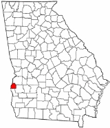
Quitman County is a county located in the U.S. state
of Georgia
. It was created on December 10, 1858 and named after General John A. Quitman
, leader in the Mexican War
, and once Governor of Mississippi. As of 2000, the population was 2,598. The 2007 Census Estimate shows a population of 2,666. The county seat
is Georgetown
.
of 2000, there were 2,598 people, 1,047 households, and 755 families residing in the county. The population density
was 7/km² (17/mi²). There were 1,773 housing units at an average density of 5/km² (12/mi²). The racial makeup of the county was 52.12% White
, 46.88% Black
or African American
, 0.23% Native American
, 0.04% Asian
, 0.19% from other races
, and 0.54% from two or more races. 0.50% of the population were Hispanic
or Latino
of any race.
There were 1,047 households out of which 26.00% had children under the age of 18 living with them, 50.20% were married couples
living together, 18.70% had a female householder with no husband present, and 27.80% were non-families. 24.90% of all households were made up of individuals and 12.30% had someone living alone who was 65 years of age or older. The average household size was 2.48 and the average family size was 2.95.
In the county the population was spread out with 24.00% under the age of 18, 7.20% from 18 to 24, 23.60% from 25 to 44, 25.40% from 45 to 64, and 19.90% who were 65 years of age or older. The median age was 42 years. For every 100 females there were 88.90 males. For every 100 females age 18 and over, there were 85.10 males.
The median income for a household in the county was $25,875, and the median income for a family was $30,691. Males had a median income of $23,365 versus $19,069 for females. The per capita income
for the county was $14,301. About 16.10% of families and 21.90% of the population were below the poverty line, including 26.60% of those under age 18 and 24.50% of those age 65 or over.
U.S. state
A U.S. state is any one of the 50 federated states of the United States of America that share sovereignty with the federal government. Because of this shared sovereignty, an American is a citizen both of the federal entity and of his or her state of domicile. Four states use the official title of...
of Georgia
Georgia (U.S. state)
Georgia is a state located in the southeastern United States. It was established in 1732, the last of the original Thirteen Colonies. The state is named after King George II of Great Britain. Georgia was the fourth state to ratify the United States Constitution, on January 2, 1788...
. It was created on December 10, 1858 and named after General John A. Quitman
John A. Quitman
John Anthony Quitman was an American politician and soldier. He served as Governor of Mississippi from 1835 to 1836 as a Whig and again from 1850 to 1851 as a Democrat and one of the leading Fire-Eaters.-Early life:John A. Quitman studied Classics at Hartwick Seminary, graduating in 1816...
, leader in the Mexican War
Mexican War
Mexican War may refer to:*Mexican War of Independence *Mexican–American War *French intervention in Mexico *Mexican Revolution *Mexican Civil War *Cristero War *Mexican Drug War...
, and once Governor of Mississippi. As of 2000, the population was 2,598. The 2007 Census Estimate shows a population of 2,666. The county seat
County seat
A county seat is an administrative center, or seat of government, for a county or civil parish. The term is primarily used in the United States....
is Georgetown
Georgetown, Quitman County, Georgia
Georgetown is a city in Quitman County, Georgia, United States. The population was 973 at the 2000 census.- History :Georgetown was destroyed by fire in 1903; every building except for the post office and three houses were destroyed by the fire.-Geography:...
.
Geography
According to the 2000 census, the county has a total area of 160.92 square miles (416.8 km²), of which 151.54 square miles (392.5 km²) (or 94.17%) is land and 9.38 square miles (24.3 km²) (or 5.83%) is water.Major highways
 U.S. Highway 82
 Georgia State Route 27Georgia State Route 27State Route 27 is a west–east state route located in the southern part of the U.S. state of Georgia. The route travels from SR 39 east of Georgetown to U.S. 17/SR 25 in Brunswick.-Route description:...
 Georgia State Route 39Georgia State Route 39State Route 39 is a north–south state route located in the southwestern part of the U.S. state of Georgia. The route travels from Lake Seminole in southern Seminole County north to U.S. 27/SR 1 north of Lumpkin.-Route description:...
 Georgia State Route 50Georgia State Route 50State Route 50 is an east–west state route located in the southwestern part of the U.S. state of Georgia. The route travels from the Alabama state line at Georgetown east to State Route 520 in Dawson. It is cosigned with U.S. Route 82 for its entire length.-Route description:State Route 50...
Adjacent counties
- Stewart CountyStewart County, GeorgiaStewart County is a county located in the U.S. state of Georgia. It was created on December 23, 1830. The 2010 Census reflected a population of 6,058. The 2009 Census Estimate shows a population of 4,558. The county seat is Lumpkin.-History:...
(north) - Randolph CountyRandolph County, GeorgiaRandolph County is a county located in the US state of Georgia. As of 2000, the population is 7,791. The 2007 Census Estimate showed a population of 7,294. The county seat is Cuthbert.-History:Randolph County is named after Virginian John Randolph....
(east) - Clay CountyClay County, GeorgiaClay County is a county located in the U.S. state of Georgia. As of 2000, the population was 3,357. The 2007 Census Estimate shows a population of 3,207...
(south) - Barbour CountyBarbour County, AlabamaBarbour County, Alabama is a county of the U.S. state of Alabama. Its name is in honor of James Barbour, who served as Governor of Virginia. As of 2010 the population was 27,457. Its county seat is Clayton.-History:...
, AlabamaAlabamaAlabama is a state located in the southeastern region of the United States. It is bordered by Tennessee to the north, Georgia to the east, Florida and the Gulf of Mexico to the south, and Mississippi to the west. Alabama ranks 30th in total land area and ranks second in the size of its inland...
(west)
Demographics
As of the censusCensus
A census is the procedure of systematically acquiring and recording information about the members of a given population. It is a regularly occurring and official count of a particular population. The term is used mostly in connection with national population and housing censuses; other common...
of 2000, there were 2,598 people, 1,047 households, and 755 families residing in the county. The population density
Population density
Population density is a measurement of population per unit area or unit volume. It is frequently applied to living organisms, and particularly to humans...
was 7/km² (17/mi²). There were 1,773 housing units at an average density of 5/km² (12/mi²). The racial makeup of the county was 52.12% White
Race (United States Census)
Race and ethnicity in the United States Census, as defined by the Federal Office of Management and Budget and the United States Census Bureau, are self-identification data items in which residents choose the race or races with which they most closely identify, and indicate whether or not they are...
, 46.88% Black
Race (United States Census)
Race and ethnicity in the United States Census, as defined by the Federal Office of Management and Budget and the United States Census Bureau, are self-identification data items in which residents choose the race or races with which they most closely identify, and indicate whether or not they are...
or African American
Race (United States Census)
Race and ethnicity in the United States Census, as defined by the Federal Office of Management and Budget and the United States Census Bureau, are self-identification data items in which residents choose the race or races with which they most closely identify, and indicate whether or not they are...
, 0.23% Native American
Race (United States Census)
Race and ethnicity in the United States Census, as defined by the Federal Office of Management and Budget and the United States Census Bureau, are self-identification data items in which residents choose the race or races with which they most closely identify, and indicate whether or not they are...
, 0.04% Asian
Race (United States Census)
Race and ethnicity in the United States Census, as defined by the Federal Office of Management and Budget and the United States Census Bureau, are self-identification data items in which residents choose the race or races with which they most closely identify, and indicate whether or not they are...
, 0.19% from other races
Race (United States Census)
Race and ethnicity in the United States Census, as defined by the Federal Office of Management and Budget and the United States Census Bureau, are self-identification data items in which residents choose the race or races with which they most closely identify, and indicate whether or not they are...
, and 0.54% from two or more races. 0.50% of the population were Hispanic
Race (United States Census)
Race and ethnicity in the United States Census, as defined by the Federal Office of Management and Budget and the United States Census Bureau, are self-identification data items in which residents choose the race or races with which they most closely identify, and indicate whether or not they are...
or Latino
Race (United States Census)
Race and ethnicity in the United States Census, as defined by the Federal Office of Management and Budget and the United States Census Bureau, are self-identification data items in which residents choose the race or races with which they most closely identify, and indicate whether or not they are...
of any race.
There were 1,047 households out of which 26.00% had children under the age of 18 living with them, 50.20% were married couples
Marriage
Marriage is a social union or legal contract between people that creates kinship. It is an institution in which interpersonal relationships, usually intimate and sexual, are acknowledged in a variety of ways, depending on the culture or subculture in which it is found...
living together, 18.70% had a female householder with no husband present, and 27.80% were non-families. 24.90% of all households were made up of individuals and 12.30% had someone living alone who was 65 years of age or older. The average household size was 2.48 and the average family size was 2.95.
In the county the population was spread out with 24.00% under the age of 18, 7.20% from 18 to 24, 23.60% from 25 to 44, 25.40% from 45 to 64, and 19.90% who were 65 years of age or older. The median age was 42 years. For every 100 females there were 88.90 males. For every 100 females age 18 and over, there were 85.10 males.
The median income for a household in the county was $25,875, and the median income for a family was $30,691. Males had a median income of $23,365 versus $19,069 for females. The per capita income
Per capita income
Per capita income or income per person is a measure of mean income within an economic aggregate, such as a country or city. It is calculated by taking a measure of all sources of income in the aggregate and dividing it by the total population...
for the county was $14,301. About 16.10% of families and 21.90% of the population were below the poverty line, including 26.60% of those under age 18 and 24.50% of those age 65 or over.
Cities and towns
- GeorgetownGeorgetown, Quitman County, GeorgiaGeorgetown is a city in Quitman County, Georgia, United States. The population was 973 at the 2000 census.- History :Georgetown was destroyed by fire in 1903; every building except for the post office and three houses were destroyed by the fire.-Geography:...
- MorrisMorris, GeorgiaMorris is an unincorporated community in southeastern Quitman County, Georgia, United States. Its elevation is 249 feet . Although it is unincorporated, it has a post office, with the ZIP code of 39867. The community lies a short distance to the south of U.S...