

Geography of Tajikistan
Encyclopedia
Tajikistan
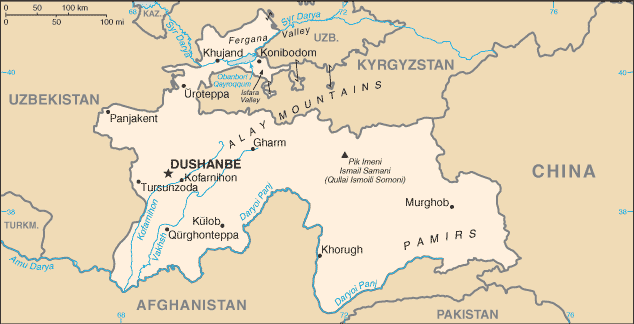
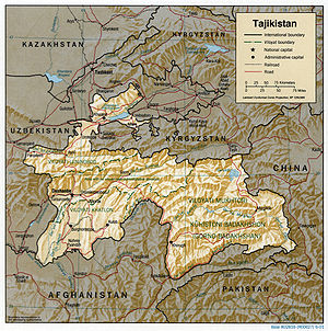
Tajikistan , officially the Republic of Tajikistan , is a mountainous landlocked country in Central Asia. Afghanistan borders it to the south, Uzbekistan to the west, Kyrgyzstan to the north, and China to the east....
is nestled between Kyrgyzstan
Kyrgyzstan
Kyrgyzstan , officially the Kyrgyz Republic is one of the world's six independent Turkic states . Located in Central Asia, landlocked and mountainous, Kyrgyzstan is bordered by Kazakhstan to the north, Uzbekistan to the west, Tajikistan to the southwest and China to the east...
and Uzbekistan
Uzbekistan
Uzbekistan , officially the Republic of Uzbekistan is a doubly landlocked country in Central Asia and one of the six independent Turkic states. It shares borders with Kazakhstan to the west and to the north, Kyrgyzstan and Tajikistan to the east, and Afghanistan and Turkmenistan to the south....
to the north and west, China
China
Chinese civilization may refer to:* China for more general discussion of the country.* Chinese culture* Greater China, the transnational community of ethnic Chinese.* History of China* Sinosphere, the area historically affected by Chinese culture...
to the east, and Afghanistan
Afghanistan
Afghanistan , officially the Islamic Republic of Afghanistan, is a landlocked country located in the centre of Asia, forming South Asia, Central Asia and the Middle East. With a population of about 29 million, it has an area of , making it the 42nd most populous and 41st largest nation in the world...
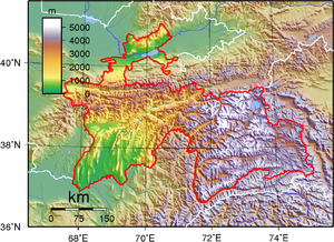
to the south. Mountains cover 93 percent of Tajikistan's surface area. The two principal ranges, the Pamir Mountains
Pamir Mountains
The Pamir Mountains are a mountain range in Central Asia formed by the junction or knot of the Himalayas, Tian Shan, Karakoram, Kunlun, and Hindu Kush ranges. They are among the world’s highest mountains and since Victorian times they have been known as the "Roof of the World" a probable...
and the Alay Mountains
Alay Mountains
The Alay or Alai Mountains is a mountain range that extends from the Tien Shan mountain range in Kyrgyzstan west into Tajikistan. It is part of the Pamir-Alay mountain system. The range runs approximately east to west. Its highest summit is Pik Tandykul , 5544 m. The southern slopes of the range...
, give rise to many glacier-fed streams and rivers, which have been used to irrigate farmlands since ancient times. Central Asia's other major mountain range, the Tian Shan
Tian Shan
The Tian Shan , also spelled Tien Shan, is a large mountain system located in Central Asia. The highest peak in the Tian Shan is Victory Peak , ....
, skirts northern Tajikistan. Mountainous terrain separates Tajikistan's two population centers, which are in the lowlands of the southern and northern sections of the country. Especially in areas of intensive agricultural and industrial activity, the Soviet Union's natural resource utilization policies left independent Tajikistan with a legacy of environmental problems.
Dimensions and borders
With an area of 143100 km² (55,251.2 sq mi), Tajikistan has a maximum east-to-west extent is 700 km (435 mi), and its maximum north-to-south extent is 350 km (217.5 mi). The country's highly irregular border is 3651 km (2,268.6 mi) long, including 414 km (257.2 mi) along the Chinese border to the east and 1206 km (749.4 mi) along the frontier with Afghanistan to the south. Most of the southern border with Afghanistan is set by the Amu DaryaAmu Darya
The Amu Darya , also called Oxus and Amu River, is a major river in Central Asia. It is formed by the junction of the Vakhsh and Panj rivers...
(darya is the Persian word for river) and its tributary the Panj River
Panj River
The Panj River , also known as Pyandzh River or Piandj River , is a tributary of the Amu Darya. The river is 1,125 km long and forms a considerable part of the Afghanistan - Tajikistan border....
(Darya-ye Panj), which has headwaters in Afghanistan and Tajikistan. The other neighbors are the former Soviet republics of Uzbekistan (to the west and the north) and Kyrgyzstan (to the north).
Topography and drainage
Turkestan Range
One of the westernmost extensions of the massive Tian Shan system, the Turkestan Range stretches for a total length of 340 km from the Alay Mountains on the border of Kyrgyzstan with Tajikistan to the Samarkand oasis in Uzbekistan...
, Zeravshan (Zarafshan), and Hisor (Gissar
Gissar Range
Gissar Range is a mountain range in Central Asia, in the western part of the Pamir-Alay system, stretching over 200 km in the general east-west direction across the territory of Tajikistan and Uzbekistan...
) mountains. The last of these lies just north of the capital, Dushanbe
Dushanbe
-Economy:Coal, lead, and arsenic are mined nearby in the cities of Nurek and Kulob allowing for the industrialization of Dushanbe. The Nurek Dam, the world's highest as of 2008, generates 95% of Tajikistan's electricity, and another dam, the Roghun Dam, is planned on the Vakhsh River...
, which is situated in west-central Tajikistan.
More than half of Tajikistan lies above an elevation of 3000 metres (9,842.5 ft). Even the lowlands, which are located in the Fergana Valley
Fergana Valley
The Fergana Valley or Farghana Valley is a region in Central Asia spreading across eastern Uzbekistan, Kyrgyzstan and Tajikistan. Divided across three subdivisions of the former Soviet Union, the valley is ethnically diverse, and in the early 21st century was the scene of ethnic conflict...
in the far north and in Khatlon Province in the southwest, are well above sea level. In the Turkestan range, highest of the western chains, the maximum elevation is 5510 metres (18,077.4 ft). The highest elevations of this range are in the east, near the border with Kyrgyzstan. That region is dominated by the peaks of the Pamir-Alay mountain system, including two of the three highest elevations in the former Soviet Union: Mount Lenin
Lenin Peak
Lenin Peak , rises to in Gorno-Badakhshan on the border of Tajikistan and Kyrgyzstan, and is the second-highest point of both countries. It is considered one of the easiest 7,000 m peaks in the world to climb and it has by far the most ascents of any 7,000 m or higher peak on earth, with every...
— 7134 metres (23,405.5 ft) and Mount Communism — 7495 metres (24,589.9 ft). Several other peaks in the region also exceed 7000 metres (22,965.9 ft). The mountains contain numerous glaciers, the largest of which, Fedchenko Glacier
Fedchenko Glacier
The Fedchenko Glacier is a large glacier in the Pamir Mountains of north-central Gorno-Badakhshan province, Tajikistan. The glacier is long and narrow, currently extending for and covering over . It is the longest glacier in the world outside of the polar regions...
, covers more than 700 square kilometres (270.3 sq mi) and is the largest glacier in the world outside the polar regions. Because Tajikistan lies in an active seismic belt, severe earthquakes are common.
The Fergana Valley, the most densely populated region in Central Asia irrigated by the Syr Darya in its upper course, spreads across the north-eastern arm of Uzbekistan and Northern Tajikistan. This long valley, which lies between two mountain ranges — the Kuramin Range in the north and the Turkestan Range
Turkestan Range
One of the westernmost extensions of the massive Tian Shan system, the Turkestan Range stretches for a total length of 340 km from the Alay Mountains on the border of Kyrgyzstan with Tajikistan to the Samarkand oasis in Uzbekistan...
in the south, reaches its lowest elevation of 320 metres (1,049.9 ft) at Khujand
Khujand
Khujand , also transliterated as Khudzhand, , formerly Khodjend or Khodzhent until 1936 and Leninabad until 1991, is the second-largest city of Tajikistan. It is situated on the Syr Darya River at the mouth of the Fergana Valley...
on the Syr Darya
Syr Darya
The Syr Darya , also transliterated Syrdarya or Sirdaryo, is a river in Central Asia, sometimes known as the Jaxartes or Yaxartes from its Ancient Greek name . The Greek name is derived from Old Persian, Yakhsha Arta , a reference to the color of the river's water...
. Rivers bring rich soil deposits into the Fergana Valley from the surrounding mountains, creating a series of fertile oases that have long been prized for agriculture.
In Tajikistan's dense river network, the largest rivers are the Syr Darya and the Amu Darya
Amu Darya
The Amu Darya , also called Oxus and Amu River, is a major river in Central Asia. It is formed by the junction of the Vakhsh and Panj rivers...
; the largest tributaries are the Vakhsh
Vakhsh River
The Vakhsh has been intensively developed for human use. Electricity, aluminum, and cotton are the mainstays of Tajikistan’s economy, and the Vakhsh is involved with all three of these sectors. Hydroelectricity provides 91% of the country’s electricity as of 2005, and 90% of that total comes from...
and the Kofarnihon
Kofarnihon River
Kofarnihon River or Kofirnihan is one of the major tributaries of Amudarya...
, which form valleys from northeast to southwest across western Tajikistan. The Amu Darya carries more water than any other river in Central Asia. The upper course of the Amu Darya, called the Panj River
Panj River
The Panj River , also known as Pyandzh River or Piandj River , is a tributary of the Amu Darya. The river is 1,125 km long and forms a considerable part of the Afghanistan - Tajikistan border....
, is 921 kilometres (572.3 mi) long. The river's name changes at the confluence of the Panj
Panj River
The Panj River , also known as Pyandzh River or Piandj River , is a tributary of the Amu Darya. The river is 1,125 km long and forms a considerable part of the Afghanistan - Tajikistan border....
, the Vakhsh
Vakhsh River
The Vakhsh has been intensively developed for human use. Electricity, aluminum, and cotton are the mainstays of Tajikistan’s economy, and the Vakhsh is involved with all three of these sectors. Hydroelectricity provides 91% of the country’s electricity as of 2005, and 90% of that total comes from...
, and the Kofarnihon
Kofarnihon River
Kofarnihon River or Kofirnihan is one of the major tributaries of Amudarya...
rivers in far southwestern Tajikistan. The Vakhsh
Vakhsh River
The Vakhsh has been intensively developed for human use. Electricity, aluminum, and cotton are the mainstays of Tajikistan’s economy, and the Vakhsh is involved with all three of these sectors. Hydroelectricity provides 91% of the country’s electricity as of 2005, and 90% of that total comes from...
, called the Kyzyl-Suu ("red water" in Turkic languages) upstream in Kyrgyzstan and the Surkhob in its middle course in north-central Tajikistan, is the second largest river in southern Tajikistan after the Amu-Panj system. In the Soviet era, the Vakhsh was dammed at several points for irrigation and electric power generation, most notably at Norak (Nurek), east of Dushanbe, where one of the world's highest dams forms the Nurek Reservoir
Nurek Dam
The Nurek Dam is an earth fill embankment dam on the Vakhsh River in the central Asian nation of Tajikistan. Construction of the dam began in 1961 and was completed in 1980, when Tajikistan was still a republic within the Soviet Union. At it is currently the tallest dam in the world...
. Numerous factories also were built along the Vakhsh to draw upon its waters and potential for electric power generation.
The two most important rivers in northern Tajikistan are the Syr Darya and the Zeravshan
Zeravshan
Zeravshan River is a river in Central Asia. Its name, "sprayer of gold" in Persian, refers to the presence of gold-bearing sands in the upper reaches of the river. To the ancient Greeks it was known as the Polytimetus...
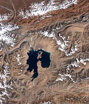
(Zarafshan). The former, the second longest river in Central Asia with a total length of 2400 kilometres (1,491.3 mi), stretches 195 kilometres (121.2 mi) across the Fergana Valley in far-northern Tajikistan. The Zeravshan River, with a total length of 781 kilometres (485.3 mi), runs for 316 kilometres (196.4 mi) through the north-center of Tajikistan. Tajikistan's rivers reach high-water levels twice a year: in the spring, fed by the rainy season and melting mountain snow, and in the summer, fed by melting glaciers. The summer freshets are the more useful for irrigation, especially in the Fergana Valley and the valleys of southeastern Tajikistan. Most of Tajikistan's lakes are of glacial origin and are located in the Pamir
Pamir Mountains
The Pamir Mountains are a mountain range in Central Asia formed by the junction or knot of the Himalayas, Tian Shan, Karakoram, Kunlun, and Hindu Kush ranges. They are among the world’s highest mountains and since Victorian times they have been known as the "Roof of the World" a probable...
region in the eastern half of the country. The largest, the Karakul (Qarokul) Lake, is a salt lake devoid of life, lying at an elevation of 4200 metres (13,779.5 ft). Tajikistan's second largest water body is the Kayrakum Reservoir, a 44 km (27.3 mi) long artificial lake in the heart of the Fergana Valley
Fergana Valley
The Fergana Valley or Farghana Valley is a region in Central Asia spreading across eastern Uzbekistan, Kyrgyzstan and Tajikistan. Divided across three subdivisions of the former Soviet Union, the valley is ethnically diverse, and in the early 21st century was the scene of ethnic conflict...
, not far from the city of Khujand
Khujand
Khujand , also transliterated as Khudzhand, , formerly Khodjend or Khodzhent until 1936 and Leninabad until 1991, is the second-largest city of Tajikistan. It is situated on the Syr Darya River at the mouth of the Fergana Valley...
in Sughd Province. The lake is fed by the Syr Darya
Syr Darya
The Syr Darya , also transliterated Syrdarya or Sirdaryo, is a river in Central Asia, sometimes known as the Jaxartes or Yaxartes from its Ancient Greek name . The Greek name is derived from Old Persian, Yakhsha Arta , a reference to the color of the river's water...
. Another well-known natural lake of glacial origin is Iskanderkul
Iskanderkul
Iskanderkul — a mountain lake of glacial origin in Tajikistan's Sughd Province. Located at an altitude of 2,195 m on the northern slopes of Gissar Range in the Fann Mountains. Triangular in shape, it has a surface area of 3.4 km2 and is up to 72 m deep...
. It is smaller than the Kayrakum Reservoir and lies in the Fann Mountains
Fann Mountains
Fann Mountains are part of the western Pamir-Alay mountain system and are located in Tajikistan's Sughd Province between the Zeravshan Range to the north and the Gissar Range to the south...
in western Tajikistan.
Climate
Tajikistan is the wettest of the Central Asian republics, with the average annual precipitation for the Kafiristan and Vakhsh valleys in the south being around 500 to 600 mm (19.7 to 23.6 in), and up to 150 mm (5.9 in) in the mountains. At the Fedchenko Glacier, as much as 223.6 cm (88 in) of snow falls each year. Only in the northern Fergana Valley and in the rain shadow areas of the eastern Pamirs is precipitation as low as in other parts of Central Asia: in the eastern Pamirs less than 100 mm (3.94 in) falls per year. Most precipitation occurs in the winter and spring.
Environmental problems
Most of Tajikistan's environmental problems are related to the agricultural policies imposed on the country during the Soviet period. By 1991 heavy use of mineral fertilizers and agricultural chemicals was a major cause of pollution in the republic. Among those chemicals were DDTDDT
DDT is one of the most well-known synthetic insecticides. It is a chemical with a long, unique, and controversial history....
, banned by international convention, and several defoliants and herbicides. In addition to the damage they have done to the air, land, and water, the chemicals have contaminated the cottonseeds whose oil is used widely for cooking. Cotton
Cotton
Cotton is a soft, fluffy staple fiber that grows in a boll, or protective capsule, around the seeds of cotton plants of the genus Gossypium. The fiber is almost pure cellulose. The botanical purpose of cotton fiber is to aid in seed dispersal....
farmers and their families are at particular risk from the overuse of agricultural chemicals, both from direct physical contact in the field and from the use of the branches of cotton plants at home for fuel. All of these toxic sources are believed to contribute to a high incidence of maternal and child mortality and birth defects. In 1994 the infant mortality rate was 43.2 per 1,000 births, the second highest rate among former Soviet republics. The rate in 1990 had been 40.0 infant deaths per 1,000 births.
Cotton requires particularly intense irrigation. In Tajikistan's cotton-growing regions, farms were established in large, semiarid tracts and in tracts reclaimed from the desert, but cotton's growing season is summer, when the region receives virtually no rainfall. The 50 percent increase in cotton cultivation mandated by Soviet and post-Soviet agricultural planners between 1964 and 1994 consequently overtaxed the regional water supply. Poorly designed irrigation networks led to massive runoff, which increased soil salinity and carried toxic agricultural chemicals downstream to other fields, the Aral Sea
Aral Sea
The Aral Sea was a lake that lay between Kazakhstan in the north and Karakalpakstan, an autonomous region of Uzbekistan, in the south...
, and populated areas of the region.
By the 1980s, nearly 90 percent of water use in Central Asia
Central Asia
Central Asia is a core region of the Asian continent from the Caspian Sea in the west, China in the east, Afghanistan in the south, and Russia in the north...
was for agriculture. Of that quantity, nearly 75 percent came from the Amu Darya
Amu Darya
The Amu Darya , also called Oxus and Amu River, is a major river in Central Asia. It is formed by the junction of the Vakhsh and Panj rivers...
and the Syr Darya, the chief tributaries of the Aral Sea on the Kazakhstan-Uzbekistan border to the northwest of Tajikistan. As the desiccation of the Aral Sea
Aral Sea
The Aral Sea was a lake that lay between Kazakhstan in the north and Karakalpakstan, an autonomous region of Uzbekistan, in the south...
came to international attention in the 1980s, water-use policy became a contentious issue between Soviet republics such as Tajikistan, where the main rivers rise, and those farther downstream, including Uzbekistan. By the end of the Soviet era, the central government had relinquished central control of water-use policy for Central Asia, but the republics had not agreed on an allocation policy.
Industry also causes pollution problems. A major offender is the production of nonferrous metals. One of Tajikistan's leading industrial sites, the aluminum plant at Tursunzoda (formerly known as Regar), west of Dushanbe near the border with Uzbekistan, generates large amounts of toxic waste gases that have been blamed for a sharp increase in the number of birth defects among people who live within range of its emissions.
In 1992 the Supreme Soviet of Tajikistan established a Ministry of Environmental Protection. However, the enforcement activity of the ministry was limited severely by the political upheavals that plagued Tajikistan in its first years of independence. The only registered private environmental group in Tajikistan in the early 1990s was a chapter of the Social-Ecological Alliance, the largest informal environmental association in the former Soviet Union. The Tajik branch's main functions have been to conduct environmental research and to organize protests against the Roghun Hydroelectric Plant project
Rogun Dam
Rogun Dam is an under construction dam on the Vakhsh River in southern Tajikistan. It is one of the planned hydroelectric power plants of Vakhsh Cascade. If finished, it would be the world's tallest dam with a height of height compared to the second tallest dam Nurek Dam at . -History:The Rogun...
.
Natural hazards: Earthquake
Earthquake
An earthquake is the result of a sudden release of energy in the Earth's crust that creates seismic waves. The seismicity, seismism or seismic activity of an area refers to the frequency, type and size of earthquakes experienced over a period of time...
s are of varying degrees and are frequent. Flood
Flood
A flood is an overflow of an expanse of water that submerges land. The EU Floods directive defines a flood as a temporary covering by water of land not normally covered by water...
ing and landslide
Landslide
A landslide or landslip is a geological phenomenon which includes a wide range of ground movement, such as rockfalls, deep failure of slopes and shallow debris flows, which can occur in offshore, coastal and onshore environments...
s sometimes occur during the annual Spring thaw.
Environment - current issues: inadequate sanitation facilities; increasing levels of soil salinity; industrial pollution; excessive pesticide
Pesticide
Pesticides are substances or mixture of substances intended for preventing, destroying, repelling or mitigating any pest.A pesticide may be a chemical unicycle, biological agent , antimicrobial, disinfectant or device used against any pest...
s; part of the basin of the shrinking Aral Sea
Aral Sea
The Aral Sea was a lake that lay between Kazakhstan in the north and Karakalpakstan, an autonomous region of Uzbekistan, in the south...
suffers from severe overutilization of available water for irrigation and associated pollution
Environment - international agreements:
party to: Biodiversity, Climate Change, Desertification
Desertification
Desertification is the degradation of land in drylands. Caused by a variety of factors, such as climate change and human activities, desertification is one of the most significant global environmental problems.-Definitions:...
, Environmental Modification, Ozone Layer Protection
signed, but not ratified: none of the selected agreements
Pamir Mountains
Tajikistan is home to some of the highest mountains in the world, including the PamirPamir
Pamir may refer to:* a pamir, a U-shaped grassy valley in the Pamir Mountains**Great Pamir, a high valley in the Wakhan on the border of Afghanistan and Tajikistan**Little Pamir, a high valley in the Wakhan, Afghanistan...
and Alay
Alay Mountains
The Alay or Alai Mountains is a mountain range that extends from the Tien Shan mountain range in Kyrgyzstan west into Tajikistan. It is part of the Pamir-Alay mountain system. The range runs approximately east to west. Its highest summit is Pik Tandykul , 5544 m. The southern slopes of the range...
ranges. 93% of Tajikistan is mountainous with altitudes ranging from 300 m (984.3 ft) to almost 7500 m (24,606.3 ft), and nearly 50% of Tajikistan's territory is above 3000 m (9,842.5 ft).
The massive mountain ranges are cut by hundreds of canyon
Canyon
A canyon or gorge is a deep ravine between cliffs often carved from the landscape by a river. Rivers have a natural tendency to reach a baseline elevation, which is the same elevation as the body of water it will eventually drain into. This forms a canyon. Most canyons were formed by a process of...
s and gorges at the bottom of which run streams that flow into larger river valleys where the majority of the country's population lives and works. The Pamir
Pamir
Pamir may refer to:* a pamir, a U-shaped grassy valley in the Pamir Mountains**Great Pamir, a high valley in the Wakhan on the border of Afghanistan and Tajikistan**Little Pamir, a high valley in the Wakhan, Afghanistan...
s in particular are heavily glaciated
Glacier
A glacier is a large persistent body of ice that forms where the accumulation of snow exceeds its ablation over many years, often centuries. At least 0.1 km² in area and 50 m thick, but often much larger, a glacier slowly deforms and flows due to stresses induced by its weight...
, and Tajikistan is home to the largest non-polar glacier in the world, the Fedchenko Glacier
Fedchenko Glacier
The Fedchenko Glacier is a large glacier in the Pamir Mountains of north-central Gorno-Badakhshan province, Tajikistan. The glacier is long and narrow, currently extending for and covering over . It is the longest glacier in the world outside of the polar regions...
.
The Pamir Mountains in Tajikistan lie in Gorno-Badakhshan Autonomous Province
Gorno-Badakhshan Autonomous Province
Gorno-Badakhshan Autonomous Province is an autonomous, mountainous province in the east of Tajikistan. Located in the Pamir Mountains, it makes up 45% of the land area of the country but only 3% of the population....
(GBAO) in the east half of the country. The northern border is formed by the Trans-Alay Range
Trans-Alay Range
The Trans-Alay Range is the northernmost range of the Pamir Mountains , where the Pamirs and the Tian Shan come together. They form the border between Osh Province, Kyrgyzstan and Gorno-Badakshan province, Tajikistan. To the north is the Alay Valley and to the south, the Muksu River. The highest...
(Independence Peak
Independence Peak
Independence Peak or Qullai Istiqlol , at , is the fourth highest peak in Pamir Mountains, located at the center of Tajikistan's Gorno-Badakhshan Autonomous Province, above the source of Yazgulem River in the Yazgulem Range. The mountain consists of three snow and ice covered summits and its...
7174 m (23,536.7 ft), Kyzylart Pass
Kyzylart Pass
Kyzylart Pass is a mountain pass and border crossing in the Trans-Alay Range on the border of Tajikistan and Kyrgyzstan.The highest point is 4,280 m . The pass is crossed by a road. Throughout the area, the land is typically rugged and dry....
4280 m (14,042 ft)). The highest peak is Ismoil Somoni Peak (7495 m (24,589.9 ft)) (formerly known as Communism Peak), on the north-western edge of GBAO. It lies between Ibn Sina Peak (7134 m (23,405.5 ft)) (also known as Lenin Peak
Lenin Peak
Lenin Peak , rises to in Gorno-Badakhshan on the border of Tajikistan and Kyrgyzstan, and is the second-highest point of both countries. It is considered one of the easiest 7,000 m peaks in the world to climb and it has by far the most ascents of any 7,000 m or higher peak on earth, with every...
) on the border with Kyrgyzstan
Kyrgyzstan
Kyrgyzstan , officially the Kyrgyz Republic is one of the world's six independent Turkic states . Located in Central Asia, landlocked and mountainous, Kyrgyzstan is bordered by Kazakhstan to the north, Uzbekistan to the west, Tajikistan to the southwest and China to the east...
to the north and Peak Korzhenevskaya
Peak Korzhenevskaya
Peak Korzhenevskaya is the third highest peak in the Pamir Mountains of Tajikistan. It is one of the five "Snow Leopard Peaks" in the territory of theformer Soviet Union. It is named after Evgenia Korzhenevskaya, the wife of Russiangeographer Nikolai L...
(7105 m (23,310.4 ft)) in Akademii Nauk Range (6785 m (22,260.5 ft)) further south. The southern border is formed by the northernmost ridges of the Karakoram Range, with Mayakovskiy Peak
Mayakovskiy Peak
Mayakovskiy Peak is a peak in Pamir Mountains, in the extreme south-west corner of Tajikistan's Gorno-Badakhshan Autonomous Province , where the north-south Ishkoshim Range joins the east-west Shakhdara Range. Elevation 6,096 m. Discovered in the early 1930s by Soviet explorer Luknitskiy, who gave...
(6096 m (20,000 ft)), Karl Marx Peak
Karl Marx Peak
Karl Marx Peak rises to in the Shakhdara Range in Pamir Mountains, in the south-west of Tajikistan's Gorno-Badakhshan Autonomous Province , near Panj River on the border with Afghanistan. The highest summit in the Shakhdara Range, it was discovered and named in 1937 by Soviet geologist and...
(6726 m (22,066.9 ft)), Engels Peak (6510 m (21,358.3 ft)), and Concord Peak
Concord Peak
Concord Peak is a mountain of the Pamirs, on the Afghan-Tajik border, about south of Lake Zorkul....
(5469 m (17,942.9 ft)) stretching west to east along the border to Afghanistan.
Rivers
The principal rivers of Central AsiaCentral Asia
Central Asia is a core region of the Asian continent from the Caspian Sea in the west, China in the east, Afghanistan in the south, and Russia in the north...
, the Amu Darya
Amu Darya
The Amu Darya , also called Oxus and Amu River, is a major river in Central Asia. It is formed by the junction of the Vakhsh and Panj rivers...
and the Syr Darya
Syr Darya
The Syr Darya , also transliterated Syrdarya or Sirdaryo, is a river in Central Asia, sometimes known as the Jaxartes or Yaxartes from its Ancient Greek name . The Greek name is derived from Old Persian, Yakhsha Arta , a reference to the color of the river's water...
, both flow through Tajikistan, fed by melting snow and glaciers from the mountains of Tajikistan and Kyrgyzstan. There are over 900 rivers in Tajikistan longer than 10 kilometres (6.2 mi).
The largest rivers of Tajikistan are:
- Amu DaryaAmu DaryaThe Amu Darya , also called Oxus and Amu River, is a major river in Central Asia. It is formed by the junction of the Vakhsh and Panj rivers...
/PanjPanj RiverThe Panj River , also known as Pyandzh River or Piandj River , is a tributary of the Amu Darya. The river is 1,125 km long and forms a considerable part of the Afghanistan - Tajikistan border.... - Bartang
- Gunt
- KofarnihonKofarnihon RiverKofarnihon River or Kofirnihan is one of the major tributaries of Amudarya...
(Kafirnigan) - KyzylsuKyzylsu RiverKyzylsu River rises on the southern slopes of the Vakhsh Range in the north-east of Tajikistan's Khatlon Province and runs south-west for a length of 230 km until joining Panj River on the border with Afghanistan. Merges with Yakhsu River as a major left tributary south of the town of Kulyab...
- MuksuMuksu RiverThe Muksu River is a west-flowing river in north-central Gorno-Badakhshan province, Tajikistan. It is a tributary of the Vakhsh River which in turn is a tributary of the Amu Darya. The north side of its valley is the Trans-Alay Range and the south side is formed by the high mountains near the...
- Murghab
- ObihingouVakhsh RiverThe Vakhsh has been intensively developed for human use. Electricity, aluminum, and cotton are the mainstays of Tajikistan’s economy, and the Vakhsh is involved with all three of these sectors. Hydroelectricity provides 91% of the country’s electricity as of 2005, and 90% of that total comes from...
- Oksu
- Syr DaryaSyr DaryaThe Syr Darya , also transliterated Syrdarya or Sirdaryo, is a river in Central Asia, sometimes known as the Jaxartes or Yaxartes from its Ancient Greek name . The Greek name is derived from Old Persian, Yakhsha Arta , a reference to the color of the river's water...
- SurkhandaryaSurxondaryo RiverSurxondaryo River, also Surkhandarya River, Surxon River, Surkhan River, Surkhan Darya is a river in Uzbekistan, a right tributary of the Amu Darya. Length: 175 km., basin: 13,500 sw. km....
- VakhshVakhsh RiverThe Vakhsh has been intensively developed for human use. Electricity, aluminum, and cotton are the mainstays of Tajikistan’s economy, and the Vakhsh is involved with all three of these sectors. Hydroelectricity provides 91% of the country’s electricity as of 2005, and 90% of that total comes from...
/Surkhob - VanjVanj RiverThe Vanj River is a river in east Tajikistan. It is a right tributary of the Panj River in Vanj district, north-western Gorno-Badakhshan. It flows southwest between the Darvoz Range to the north and the Vanj Range to the south, joining the Panj at . The Vanj valley is broader and more fertile...
- YazgulyamYazgulyam RiverThe Yazgulyam River is a tributary of the Panj in Vanj district, western Gorno-Badakhshan, Tajikistan....
- Zeravshan
Lakes
About 2% of the country's area is covered by lakes:- Kayrakum (Qairoqqum) ReservoirGhafurov districtGhafurov District or Nohiya-i Ghafurov is a district in the northern part of Sughd province, Tajikistan. Its capital is Ghafurov, a town in the south of the district...
(SughdSughdSughd Province is one of the four administrative divisions and one of the three provinces that make up Tajikistan. Centered in the historical Sogdiana, it is located in the northwest of the country, with an area of some 25,400 square kilometers and a population of 2,132,100 , up from 1,870,000...
) - IskanderkulIskanderkulIskanderkul — a mountain lake of glacial origin in Tajikistan's Sughd Province. Located at an altitude of 2,195 m on the northern slopes of Gissar Range in the Fann Mountains. Triangular in shape, it has a surface area of 3.4 km2 and is up to 72 m deep...
(Fann MountainsFann MountainsFann Mountains are part of the western Pamir-Alay mountain system and are located in Tajikistan's Sughd Province between the Zeravshan Range to the north and the Gissar Range to the south...
) - KulikalonFann MountainsFann Mountains are part of the western Pamir-Alay mountain system and are located in Tajikistan's Sughd Province between the Zeravshan Range to the north and the Gissar Range to the south...
(Kul-i Kalon) (Fann MountainsFann MountainsFann Mountains are part of the western Pamir-Alay mountain system and are located in Tajikistan's Sughd Province between the Zeravshan Range to the north and the Gissar Range to the south...
) - Nurek ReservoirNurek DamThe Nurek Dam is an earth fill embankment dam on the Vakhsh River in the central Asian nation of Tajikistan. Construction of the dam began in 1961 and was completed in 1980, when Tajikistan was still a republic within the Soviet Union. At it is currently the tallest dam in the world...
(KhatlonKhatlonKhatlon Province , sometimes misspelt Khatlan, one of the three provinces of Tajikistan and is the most populous of the four first level administrative regions. It is situated in the southwest of the country, between the Hisor Range in the north and the Panj River in the south and borders on...
) - Bulunkul (PamirPamir MountainsThe Pamir Mountains are a mountain range in Central Asia formed by the junction or knot of the Himalayas, Tian Shan, Karakoram, Kunlun, and Hindu Kush ranges. They are among the world’s highest mountains and since Victorian times they have been known as the "Roof of the World" a probable...
) - Drumkul (PamirPamir MountainsThe Pamir Mountains are a mountain range in Central Asia formed by the junction or knot of the Himalayas, Tian Shan, Karakoram, Kunlun, and Hindu Kush ranges. They are among the world’s highest mountains and since Victorian times they have been known as the "Roof of the World" a probable...
) - Karakul ' onMouseout='HidePop("78105")' href="/topics/Pamir_Mountains">PamirPamir MountainsThe Pamir Mountains are a mountain range in Central Asia formed by the junction or knot of the Himalayas, Tian Shan, Karakoram, Kunlun, and Hindu Kush ranges. They are among the world’s highest mountains and since Victorian times they have been known as the "Roof of the World" a probable...
) - Rangkul (PamirPamir MountainsThe Pamir Mountains are a mountain range in Central Asia formed by the junction or knot of the Himalayas, Tian Shan, Karakoram, Kunlun, and Hindu Kush ranges. They are among the world’s highest mountains and since Victorian times they have been known as the "Roof of the World" a probable...
)
- SarezSarez Lake-External links:****...
(PamirPamir MountainsThe Pamir Mountains are a mountain range in Central Asia formed by the junction or knot of the Himalayas, Tian Shan, Karakoram, Kunlun, and Hindu Kush ranges. They are among the world’s highest mountains and since Victorian times they have been known as the "Roof of the World" a probable...
) - Sasykkul (PamirPamir MountainsThe Pamir Mountains are a mountain range in Central Asia formed by the junction or knot of the Himalayas, Tian Shan, Karakoram, Kunlun, and Hindu Kush ranges. They are among the world’s highest mountains and since Victorian times they have been known as the "Roof of the World" a probable...
) - Shadau Lake (PamirPamir MountainsThe Pamir Mountains are a mountain range in Central Asia formed by the junction or knot of the Himalayas, Tian Shan, Karakoram, Kunlun, and Hindu Kush ranges. They are among the world’s highest mountains and since Victorian times they have been known as the "Roof of the World" a probable...
) - Shorkul (PamirPamir MountainsThe Pamir Mountains are a mountain range in Central Asia formed by the junction or knot of the Himalayas, Tian Shan, Karakoram, Kunlun, and Hindu Kush ranges. They are among the world’s highest mountains and since Victorian times they have been known as the "Roof of the World" a probable...
) - Turumtaikul (PamirPamir MountainsThe Pamir Mountains are a mountain range in Central Asia formed by the junction or knot of the Himalayas, Tian Shan, Karakoram, Kunlun, and Hindu Kush ranges. They are among the world’s highest mountains and since Victorian times they have been known as the "Roof of the World" a probable...
) - Tuzkul (PamirPamir MountainsThe Pamir Mountains are a mountain range in Central Asia formed by the junction or knot of the Himalayas, Tian Shan, Karakoram, Kunlun, and Hindu Kush ranges. They are among the world’s highest mountains and since Victorian times they have been known as the "Roof of the World" a probable...
) - Yashilkul (PamirPamir MountainsThe Pamir Mountains are a mountain range in Central Asia formed by the junction or knot of the Himalayas, Tian Shan, Karakoram, Kunlun, and Hindu Kush ranges. They are among the world’s highest mountains and since Victorian times they have been known as the "Roof of the World" a probable...
) - ZorkulZorkulZorkul is a lake in the Pamir Mountains that runs along the border between Afghanistan and Tajikistan. It extends east to west for about 25 km. The Afghan-Tajik border runs along the lake from east to west, turning south towards Concord Peak , about 15 km south of the lake. The lake's northern...
(PamirPamir MountainsThe Pamir Mountains are a mountain range in Central Asia formed by the junction or knot of the Himalayas, Tian Shan, Karakoram, Kunlun, and Hindu Kush ranges. They are among the world’s highest mountains and since Victorian times they have been known as the "Roof of the World" a probable...
)
Area and boundaries
Area:total: 143100 km² (55,251.2 sq mi)
land: 141510 km² (54,637.3 sq mi)
water: 2590 km² (1,000 sq mi)
Area - comparative: slightly smaller than Wisconsin
Wisconsin
Wisconsin is a U.S. state located in the north-central United States and is part of the Midwest. It is bordered by Minnesota to the west, Iowa to the southwest, Illinois to the south, Lake Michigan to the east, Michigan to the northeast, and Lake Superior to the north. Wisconsin's capital is...
Land boundaries:
total: 3651 km (2,268.6 mi)
border countries: Afghanistan
Afghanistan
Afghanistan , officially the Islamic Republic of Afghanistan, is a landlocked country located in the centre of Asia, forming South Asia, Central Asia and the Middle East. With a population of about 29 million, it has an area of , making it the 42nd most populous and 41st largest nation in the world...
1206 km (749.4 mi), China
China
Chinese civilization may refer to:* China for more general discussion of the country.* Chinese culture* Greater China, the transnational community of ethnic Chinese.* History of China* Sinosphere, the area historically affected by Chinese culture...
414 km (257.2 mi), Kyrgyzstan
Kyrgyzstan
Kyrgyzstan , officially the Kyrgyz Republic is one of the world's six independent Turkic states . Located in Central Asia, landlocked and mountainous, Kyrgyzstan is bordered by Kazakhstan to the north, Uzbekistan to the west, Tajikistan to the southwest and China to the east...
870 km (540.6 mi), Uzbekistan
Uzbekistan
Uzbekistan , officially the Republic of Uzbekistan is a doubly landlocked country in Central Asia and one of the six independent Turkic states. It shares borders with Kazakhstan to the west and to the north, Kyrgyzstan and Tajikistan to the east, and Afghanistan and Turkmenistan to the south....
1161 km (721.4 mi)
Coastline: 0 km (0 mi) (landlocked
Landlocked
A landlocked country is a country entirely enclosed by land, or whose only coastlines lie on closed seas. There are 48 landlocked countries in the world, including partially recognized states...
)
Maritime claims: none (landlocked)
Elevation extremes:
lowest point: Syr Darya
Syr Darya
The Syr Darya , also transliterated Syrdarya or Sirdaryo, is a river in Central Asia, sometimes known as the Jaxartes or Yaxartes from its Ancient Greek name . The Greek name is derived from Old Persian, Yakhsha Arta , a reference to the color of the river's water...
300 m (984.3 ft)
highest point: Ismoil Somoni Peak 7495 m (24,589.9 ft)
Other peaks include: Lenin Peak
Lenin Peak
Lenin Peak , rises to in Gorno-Badakhshan on the border of Tajikistan and Kyrgyzstan, and is the second-highest point of both countries. It is considered one of the easiest 7,000 m peaks in the world to climb and it has by far the most ascents of any 7,000 m or higher peak on earth, with every...
7134 m (23,405.5 ft); Peak Korzhenevskaya
Peak Korzhenevskaya
Peak Korzhenevskaya is the third highest peak in the Pamir Mountains of Tajikistan. It is one of the five "Snow Leopard Peaks" in the territory of theformer Soviet Union. It is named after Evgenia Korzhenevskaya, the wife of Russiangeographer Nikolai L...
7105 m (23,310.4 ft); Independence Peak
Independence Peak
Independence Peak or Qullai Istiqlol , at , is the fourth highest peak in Pamir Mountains, located at the center of Tajikistan's Gorno-Badakhshan Autonomous Province, above the source of Yazgulem River in the Yazgulem Range. The mountain consists of three snow and ice covered summits and its...
6974 m (22,880.6 ft)
Resources and land use
Natural resources:hydropower
Hydropower
Hydropower, hydraulic power, hydrokinetic power or water power is power that is derived from the force or energy of falling water, which may be harnessed for useful purposes. Since ancient times, hydropower has been used for irrigation and the operation of various mechanical devices, such as...
, some petroleum
Petroleum
Petroleum or crude oil is a naturally occurring, flammable liquid consisting of a complex mixture of hydrocarbons of various molecular weights and other liquid organic compounds, that are found in geologic formations beneath the Earth's surface. Petroleum is recovered mostly through oil drilling...
, uranium
Uranium
Uranium is a silvery-white metallic chemical element in the actinide series of the periodic table, with atomic number 92. It is assigned the chemical symbol U. A uranium atom has 92 protons and 92 electrons, of which 6 are valence electrons...
, mercury
Mercury (element)
Mercury is a chemical element with the symbol Hg and atomic number 80. It is also known as quicksilver or hydrargyrum...
, brown coal, lead
Lead
Lead is a main-group element in the carbon group with the symbol Pb and atomic number 82. Lead is a soft, malleable poor metal. It is also counted as one of the heavy metals. Metallic lead has a bluish-white color after being freshly cut, but it soon tarnishes to a dull grayish color when exposed...
, zinc
Zinc
Zinc , or spelter , is a metallic chemical element; it has the symbol Zn and atomic number 30. It is the first element in group 12 of the periodic table. Zinc is, in some respects, chemically similar to magnesium, because its ion is of similar size and its only common oxidation state is +2...
, antimony
Antimony
Antimony is a toxic chemical element with the symbol Sb and an atomic number of 51. A lustrous grey metalloid, it is found in nature mainly as the sulfide mineral stibnite...
, tungsten
Tungsten
Tungsten , also known as wolfram , is a chemical element with the chemical symbol W and atomic number 74.A hard, rare metal under standard conditions when uncombined, tungsten is found naturally on Earth only in chemical compounds. It was identified as a new element in 1781, and first isolated as...
Land use (2006 data):
arable land: 6%
permanent crops: 1%
pastures: 21%
non-agricultural land: 72%
including forests and woodland: 3%
Irrigated land:
1991: 6945 km² (2,681.5 sq mi)
2003: 7220 km² (2,787.7 sq mi)
2006: 7235 km² (2,793.4 sq mi)