

Geography of Ladakh
Encyclopedia

Ladakh
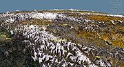
Ladakh is a region of Jammu and Kashmir, the northernmost state of the Republic of India. It lies between the Kunlun mountain range in the north and the main Great Himalayas to the south, inhabited by people of Indo-Aryan and Tibetan descent...
is the highest altitude plateau
Plateau
In geology and earth science, a plateau , also called a high plain or tableland, is an area of highland, usually consisting of relatively flat terrain. A highly eroded plateau is called a dissected plateau...
region in India
India
India , officially the Republic of India , is a country in South Asia. It is the seventh-largest country by geographical area, the second-most populous country with over 1.2 billion people, and the most populous democracy in the world...
(much of it being over 3,000 m), straddling the Himalayan
Himalayas
The Himalaya Range or Himalaya Mountains Sanskrit: Devanagari: हिमालय, literally "abode of snow"), usually called the Himalayas or Himalaya for short, is a mountain range in Asia, separating the Indian subcontinent from the Tibetan Plateau...
and Karakoram
Karakoram
The Karakoram, or Karakorum , is a large mountain range spanning the borders between Pakistan, India and China, located in the regions of Gilgit-Baltistan , Ladakh , and Xinjiang region,...
mountain range
Mountain range
A mountain range is a single, large mass consisting of a succession of mountains or narrowly spaced mountain ridges, with or without peaks, closely related in position, direction, formation, and age; a component part of a mountain system or of a mountain chain...
s and the upper Indus River
Indus River
The Indus River is a major river which flows through Pakistan. It also has courses through China and India.Originating in the Tibetan plateau of western China in the vicinity of Lake Mansarovar in Tibet Autonomous Region, the river runs a course through the Ladakh district of Jammu and Kashmir and...
valley.
The mountain ranges in this region were formed over a period of 45 million years by the folding of the Indian Plate into the stationary landmass of Asia. While the Himalayas were formed from the base material of the Indian plate, the Zanskar Range consists of layers of sediment from the ocean floor, and the Ladakh Range
Ladakh range
The Ladakh Range is a segmentf the Karakoram Range, that extends southeastward for 230 miles from the mouth of the Shyok River in the Ladakh region to the Tibetan border...
of granite
Granite
Granite is a common and widely occurring type of intrusive, felsic, igneous rock. Granite usually has a medium- to coarse-grained texture. Occasionally some individual crystals are larger than the groundmass, in which case the texture is known as porphyritic. A granitic rock with a porphyritic...
was born of the immense heat generated by the friction between the two plates. In Ladakh, the suture zone between the continental masses runs a little to the south of the Indus Valley. The drift continues and is the cause of the frequent earthquakes in the Himalayan region. Crossing the Himalayas by the dip of the Zoji-la, the crest-line of the range remains at a relatively modest level, the highest peaks near the pass being little more than 5000–5500 m above sea level. South-east of Zoji-la the scale increases, reaching a climax in the mighty massif of Nun-Kun, with two summits over 7000 m.
The Suru
Suru valley
The Suru valley is a valley in the Ladakh region of Jammu and Kashmir, which is drained by the Suru River , a powerful tributary of the Indus river. The valley's most significant town is Kargil.-People of the Suru Valley:...
and Zanskar
Zanskar
Zanskar is a subdistrict or tehsil of the Kargil district, which lies in the eastern half of the Indian state of Jammu and Kashmir. The administrative centre is Padum...
valleys form a great trough at the foot of the northern, heavily glaciated flank of the Himalayas, while opposite rise the mountains of the Zanskar range. The Suru River forms the western and northern boundary of the Zanskar range. The Suru, after receiving the combined waters of the Dras
Dras river
The Dras River is a tributary of the Suru River, and originates in the Machoi Glacier situated near the Zozi-la Pass....
and Shingo River
Shingo river
The Shingo River is a tributary of the Suru River, and flows through the Ladakh region. The Shingo river enters India from Pakistan-administered Kashmir and meets the Dras River, coming from Dras...
s a short distance north of Kargil
Kargil District
Kargil is a district of Ladakh, Kashmir, India. Kargil lies near the Line of Control facing Pakistan-occupied Kashmir's Baltistan to the west, and Kashmir valley to the south. Zanskar is part of Kargil district along with Suru, Wakha and Dras valleys...
, joins the Indus at Marol in Baltistan
Baltistan
Baltistan , also known as بلتیول བལིུལ་ in the Balti language, is a region in northern Pakistan which forms Gilgit-Baltistan, bordering the Xinjiang Autonomous Region of China. In addition, a part of Baltistan also falls into Jammu and Kashmir of India. It is situated in the Karakoram mountains...
, which is now on the Pakistan
Pakistan
Pakistan , officially the Islamic Republic of Pakistan is a sovereign state in South Asia. It has a coastline along the Arabian Sea and the Gulf of Oman in the south and is bordered by Afghanistan and Iran in the west, India in the east and China in the far northeast. In the north, Tajikistan...
side of the Line of Control
Line of Control
The term Line of Control refers to the military control line between the Indian- and Pakistani-controlled parts of the former princely state of Jammu and Kashmir—a line which, to this day, does not constitute a legally recognized international boundary but is the de facto border...
. Rangdum
Rangdum
Rangdum is in a valley situated 3,657 m above the sea level, in an isolated region of the Suru valley in the Ladakh region in the state of Jammu and Kashmir in Northern India. On one side are the colorful hills while on the other side are rocky mountains and glaciers, notably Drang-drung.Rangdum...
Monastery and the attendant village of Julidok is the last inhabited region in the Suru valley; it is also the destination of the nomadic herdspeople called Bakarwal
Bakarwal
Bakarwal is a nomadic tribe based in the Pir Panjal and Himalayan mountains of South Asia. They are mainly goatherds and shepherds. They are called as Dhangar in rest of India.- Etymology :...
s, who trek up every summer from the Jammu
Jammu
Jammu , also known as Duggar, is one of the three administrative divisions within Jammu and Kashmir, the northernmost state in India.Jammu city is the largest city in Jammu and the winter capital of Jammu and Kashmir...
region. From Rangdum the valley rises to 4400 metres at the Pensi-la
Pensi-la
Pensi-la is a mountain pass in the Ladakh region of Jammu and Kashmir, which is known as the Gateway to Zanskar. Pensi La is 4,400 m above sea level and connects the Suru Valley region to the Zanskar Valley region...
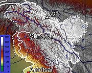
, the gateway into Zanskar. Kargil, the only town in the Suru valley, was an important staging post on the routes of the trade caravans before 1947, being more or less equidistant, at about 230 kilometres from Srinagar
Srinagar
Srinagar is the summer seasonal capital of Jammu and Kashmir. It is situated in Kashmir Valley and lies on the banks of the Jhelum River, a tributary of the Indus. It is one of the largest cities in India not to have a Hindu majority. The city is famous for its gardens, lakes and houseboats...
, Leh, Skardo, and Padum
Padum
Padum is the largest town and administrative centre of Zanskar tehsil of Kargil district in the state of Jammu and Kashmir, India. It is 240 km away from Kargil.-Description:...
. Rangdum, though on the northern side of the Pensi-la, is regarded as socially and culturally part of Zangskar rather than of Suru.

Bara-lacha-la
Bara-lacha la also known as Bara-lacha Pass, or Bārā Lācha La, is a high mountain pass in Zanskar range, connecting Lahaul district in Himachal Pradesh to Ladakh in Jammu and Kashmir, situated along the Leh-Manali highway....
it is joined by the Lingti and another tributary; it then flows north-west before turning abruptly south through a gorge and past Phugtal Gompa to join the Kargyak river descending from Shingo-la
Shingo-la
Shingo-la is a mountain pass in India, on the border between Jammu and Kashmir and Himachal Pradesh. There is a shallow lake or pool 20m below the pass. The pass is on a long-distance footpath linking Zanskar and Lahaul, used often by locals and trekkers alike...
, that goes into Himachal Pradesh
Himachal Pradesh
Himachal Pradesh is a state in Northern India. It is spread over , and is bordered by the Indian states of Jammu and Kashmir on the north, Punjab on the west and south-west, Haryana and Uttar Pradesh on the south, Uttarakhand on the south-east and by the Tibet Autonomous Region on the east...
. The Stod carries meltwater of the Drang-drung
Drang-drung
The Drang-Drung Glacier is the largest glacier in Ladakh, Jammu and Kashmir, India, situated near the Pensi La. The Stod River originates from this glacier....
glacier below the Pensi-la, and flows down a broad open valley, approaching the Lungnak. As the Zangskar river, their united waters flow northwards through a gorge in the Zanskar range, to join the Indus at Nyemo in Central Ladakh. Zanskar suffers heavy snowfall, and the Pensi-la opens only in June and is blocked again in mid-October. The entire valley is virtually treeless.
The Indus river is the backbone of Ladakh—all the major places historically and currently, Shey
Shey
Shey is a town in Ladakh that has the old summer Palace of the kings of Ladakh. It is located 15 km. from Leh towards Hemis. The palace was built more than 555 years ago by Lhachen Palgyigon, the king of Ladakh...
, Leh, Basgo
Basgo
Basgo is a historical town situated on the bank of the Indus river in Ladakh. It was once an important cultural and political centre and is frequently mentioned in the Ladakhi Chronicles. It is known for its gompas such as Basgo Monastery and historical ruins....
, and Tingmosgang
Tingmosgang
Tingmosgang is a town on the bank of Indus River in Ladakh, in northwestern India. It is 92 km west of Leh, near Khalatse, and north of the present main road. The town has a palace and the monastery over a hillock.-History:...
, are situated close to the river.
The Ladakh range has no major peaks; its average height is a little less than 6000 metres, and few of its passes are less than 5000 m. Within Ladakh it forms the northern boundary wall of the Indus valley, though when the river enters Ladakh at Demchok, some 250 km south-east of Leh, it is actually flowing along the foot of the northern flank of these granite mountains, which it crosses by a great gorge close to its confluence with the Hanle river. The Pang-gong range runs parallel to the Ladakh range some 100 km northwest from Chushul, along the southern shore of the Pang-gong Lake. It is divided from the main range by the Tangtse river. Its highest range is 6700 m, and the northern slopes are heavily glaciated.
The Shyok River
Shyok River
The Shyok River flows through northern Ladakh in India and the Northern Areas of Pakistan , spanning some .The Shyok River, a tributary of the Indus River, originates from the Rimo Glacier, one of the tongues of Siachen Glacier. The river widens at the confluence with the Nubra River...
rises just below the Karakoram Pass
Karakoram Pass
The Karakoram Pass is a mountain pass between India and China in the Karakoram Range. It is the highest pass on the ancient caravan route between Leh in Ladakh and Yarkand in the Tarim Basin...
. The region comprising the valley of Shyok and Nubra rivers is known as Nubra. The Karakoram range in Ladakh is not as mighty as in Baltistan. The massifs to the north and east of the Nubra-Siachan line include the Apsarasas group (highest point 7245 m), the Rimo group (highest point 7385 m) and the Teram Kangri group (highest point 7464 m), together with Mamostong Kangri (7526m) and Singhi Kangri (7751 m.) North of the Karakoram lie the Kun-lun mountains. Thus, between Leh and eastern Central Asia, there is a triple barrier—Ladakh range, Karakoram range, and Kun-lun. Nevertheless, a major trade route was established between Leh and Yarkand.
Rain shadow
A rain shadow is a dry area on the lee side of a mountainous area. The mountains block the passage of rain-producing weather systems, casting a "shadow" of dryness behind them. As shown by the diagram to the right, the warm moist air is "pulled" by the prevailing winds over a mountain...
, denying entry to the moisture-laden clouds of the Indian monsoon
Monsoon
Monsoon is traditionally defined as a seasonal reversing wind accompanied by corresponding changes in precipitation, but is now used to describe seasonal changes in atmospheric circulation and precipitation associated with the asymmetric heating of land and sea...
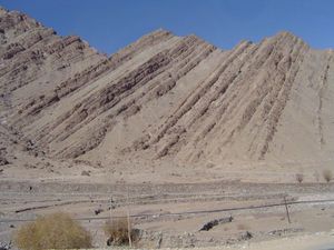
. Ladakh is thus, a high altitude desert. The main source of water is the winter snowfall on the mountains. The regions on the north flank of the Himalayas—Dras, the Suru valley and Zanskar—experience heavy snowfall and remain virtually cut off from the rest of the country for several months in the year. Summers are short, although long enough to grow crops. The proportion of oxygen is less than in many other places at a comparable altitude because of lack of vegetation. There is little moisture to temper the effects of rarefied air.
Naked barley (Urdu: grim), normal barley and wheat are the staple crops all over Ladakh, along with mustard (for oil), lentils and other pulses, and vegetables. The extreme limit of cultivation is at Korzok near Tso-Moriri Lake, at 4600 m, said to be the highest fields in the world.
Historic Ladakh consists of a number of distinct areas (mainly under Indian rule), including the fairly populous main Indus valley, the more remote Zanskar
Zanskar
Zanskar is a subdistrict or tehsil of the Kargil district, which lies in the eastern half of the Indian state of Jammu and Kashmir. The administrative centre is Padum...
(in the south) and Nubra
Nubra
Nubra may refer to:In the Indian subcontinent:* Nubra Valley, in the Jammu and Kashmir region* Nubra River, in the Jammu and Kashmir region* Nubra Pika , a mammalOther:* NuBra, a strapless brassiere...
valleys (to the north over Khardung La
Khardung La
Khardung La is a high mountain pass located in the Ladakh region, Jammu and Kashmir, India...
in the Ladakh mountain range, a high motorable pass at 5359 metres (17,582 ft)), the almost deserted Aksai Chin
Aksai Chin
Aksai Chin is one of the two main disputed border areas between China and India, and the other is South Tibet, which comprises most of India's Arunachal Pradesh. It is administered by China as part of Hotan County in the Hotan Prefecture of Xinjiang Autonomous Region, but is also claimed by India...
(under Chinese rule) and the predominantly Shi'ite Muslim Kargil
Kargil District
Kargil is a district of Ladakh, Kashmir, India. Kargil lies near the Line of Control facing Pakistan-occupied Kashmir's Baltistan to the west, and Kashmir valley to the south. Zanskar is part of Kargil district along with Suru, Wakha and Dras valleys...
and Suru
Suru valley
The Suru valley is a valley in the Ladakh region of Jammu and Kashmir, which is drained by the Suru River , a powerful tributary of the Indus river. The valley's most significant town is Kargil.-People of the Suru Valley:...
valley areas in the west (Kargil being the second most important town in Ladakh).
The Baltistan
Baltistan
Baltistan , also known as بلتیول བལིུལ་ in the Balti language, is a region in northern Pakistan which forms Gilgit-Baltistan, bordering the Xinjiang Autonomous Region of China. In addition, a part of Baltistan also falls into Jammu and Kashmir of India. It is situated in the Karakoram mountains...
and Skardu / Skardo area, under Pakistani rule and entirely Muslim, used to be included in what is geographically referred to as Ladakh. Before partition, Baltistan was one of the districts of Ladakh. Skardo was the winter capital of Ladakh while Leh was the summer capital. People of Baltistan and Ladakh speak very similar languages closely related to Tibetan.