
Khardung La
Encyclopedia
Khardung La (elevation 5359 m or 17,582 feet) is a high mountain pass
located in the Ladakh
region, Jammu and Kashmir
, India
. The local pronunciation is "Khardong La" or "Khardzong La," but, as with most names in Ladakh, the romanised spelling varies.
The pass on the Ladakh Range
lies north of Leh and is the gateway to the Shyok and Nubra
valleys. The Siachen Glacier
lies partway up the latter valley. Built in 1976, it was opened to motor vehicles in 1988 and has since seen many automobile
, motorbike and mountain biking
expeditions. Maintained by the Border Roads Organisation
, the pass is strategically important to India as it is used to carry supplies to the Siachen Glacier
.
Khardong La is historically important as it lies on the major caravan
route from Leh to Kashgar
in Chinese Central Asia
. About 10,000 horses and camels used to take the route annually, and a small population of Bactrian camel
s can still be seen at Hundar, in the area north of the pass. During World War II
there was an attempt to transfer war material to China
through this route.
s, and motorcycle
s regularly travel into the Nubra Valley, though special permits may need to be arranged for travellers to make the journey.
 The 5,359 m elevation given above is from a modern GPS survey by a team of researchers. It accurately matches SRTM data and Russian topographic
mapping, and it is broadly consistent with several other independent travellers' GPS reports and an article by Bonington.
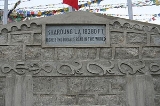
Several of these sources contain assertions by local people who claim that the 5,602 m (18,380 feet) height claimed by the summit signs has been inflated for the purpose of record breaking. The even higher elevation of 5,682 m (18,640 feet) that has been claimed by Guinness World Records
and the National Geographic Society
is not supported by any evidence and may be rooted in a copying error from 5,602 m.
 Khardung La is widely, but incorrectly, believed to be the world's highest motorable pass. There are higher motorable passes at Suge La, west of Lhasa, 5,430 m (17,815 feet), and Semo La
5,565 m (18,258 feet), between Raka and Coqen in Central Tibet
. Both these elevations are supported by GPS and SRTM evidence and the latter was also measured by the Spanish
and supported by the Cartographic Institute of Catalonia. Vehicles have been driven over the 5582 metres (18,314 ft) Marsimik La
, in the Indian Karakoram to the north-east of Khardung La, but it is debatable whether this pass should be considered to be motorable.
 The nearest town is Leh, the capital of Ladakh
. Leh is connected by road from Manali and Srinagar, and daily flights are operated from Delhi. From Leh, a daily bus service to Nubra Valley
passes over Khardungla. The ideal method to get to Khardung-la is by taxi
or bike
. Taking an experienced driver with you is advisable. The two bases on either side of Khardong-la are North Pullu and South Pullu. Inner Line Permit (ILP) is not needed to reach Khardung La peak, however Inner Line Permit is needed to cross North Pullu to reach Nubra Valley. Inner line permit can be procured at the DC's office in Leh. Travelers must provide photocopies of the permits, to be deposited at each checkpoint.
Mountain pass
A mountain pass is a route through a mountain range or over a ridge. If following the lowest possible route, a pass is locally the highest point on that route...
located in the Ladakh
Ladakh
Ladakh is a region of Jammu and Kashmir, the northernmost state of the Republic of India. It lies between the Kunlun mountain range in the north and the main Great Himalayas to the south, inhabited by people of Indo-Aryan and Tibetan descent...
region, Jammu and Kashmir
Jammu and Kashmir
Jammu and Kashmir is the northernmost state of India. It is situated mostly in the Himalayan mountains. Jammu and Kashmir shares a border with the states of Himachal Pradesh and Punjab to the south and internationally with the People's Republic of China to the north and east and the...
, India
India
India , officially the Republic of India , is a country in South Asia. It is the seventh-largest country by geographical area, the second-most populous country with over 1.2 billion people, and the most populous democracy in the world...
. The local pronunciation is "Khardong La" or "Khardzong La," but, as with most names in Ladakh, the romanised spelling varies.
The pass on the Ladakh Range
Ladakh range
The Ladakh Range is a segmentf the Karakoram Range, that extends southeastward for 230 miles from the mouth of the Shyok River in the Ladakh region to the Tibetan border...
lies north of Leh and is the gateway to the Shyok and Nubra
Nubra Valley
Nubra Valley is about 150 km north of Leh, the capital town of Ladakh, India. Local scholars say that its original name was Ldumra . The Shyok River meets the Nubra or Siachan River to form a large valley that separates the Ladakh and the Karakoram Ranges. The average altitude of the valley is...
valleys. The Siachen Glacier
Siachen Glacier
The Siachen Glacier is located in the eastern Karakoram range in the Himalaya Mountains at about , just east of the Line of Control between India-Pakistan. India controls all of the Siachen Glacier itself, including all tributary glaciers. At long, it is the longest glacier in the Karakoram and...
lies partway up the latter valley. Built in 1976, it was opened to motor vehicles in 1988 and has since seen many automobile
Automobile
An automobile, autocar, motor car or car is a wheeled motor vehicle used for transporting passengers, which also carries its own engine or motor...
, motorbike and mountain biking
Mountain bike
A mountain bike or mountain bicycle is a bicycle created for off-road cycling. This activity includes traversing of rocks and washouts, and steep declines,...
expeditions. Maintained by the Border Roads Organisation
Border Roads Organisation
The Border Roads Organisation maintains roads that serve the borders areas of India. It is staffed with a combination of Border Roads Engineering Service officers from the General Reserve Engineer Force and officers from the Corps of Engineers of the Indian Army. The organisation develops and...
, the pass is strategically important to India as it is used to carry supplies to the Siachen Glacier
Siachen Glacier
The Siachen Glacier is located in the eastern Karakoram range in the Himalaya Mountains at about , just east of the Line of Control between India-Pakistan. India controls all of the Siachen Glacier itself, including all tributary glaciers. At long, it is the longest glacier in the Karakoram and...
.
Khardong La is historically important as it lies on the major caravan
Caravan (travellers)
A caravan is a group of people traveling together, often on a trade expedition. Caravans were used mainly in desert areas and throughout the Silk Road, where traveling in groups aided in defence against bandits as well as helped to improve economies of scale in trade.In historical times, caravans...
route from Leh to Kashgar
Kashgar
Kashgar or Kashi is an oasis city with approximately 350,000 residents in the western part of the Xinjiang Uyghur Autonomous Region of the People's Republic of China. Kashgar is the administrative centre of Kashgar Prefecture which has an area of 162,000 km² and a population of approximately...
in Chinese Central Asia
Central Asia
Central Asia is a core region of the Asian continent from the Caspian Sea in the west, China in the east, Afghanistan in the south, and Russia in the north...
. About 10,000 horses and camels used to take the route annually, and a small population of Bactrian camel
Bactrian camel
The Bactrian camel is a large, even-toed ungulate native to the steppes of central Asia. It is presently restricted in the wild to remote regions of the Gobi and Taklamakan Deserts of Mongolia and Xinjiang. A small number of wild Bactrian camels still roam the Mangystau Province of southwest...
s can still be seen at Hundar, in the area north of the pass. During World War II
World War II
World War II, or the Second World War , was a global conflict lasting from 1939 to 1945, involving most of the world's nations—including all of the great powers—eventually forming two opposing military alliances: the Allies and the Axis...
there was an attempt to transfer war material to China
China
Chinese civilization may refer to:* China for more general discussion of the country.* Chinese culture* Greater China, the transnational community of ethnic Chinese.* History of China* Sinosphere, the area historically affected by Chinese culture...
through this route.
Location
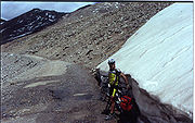
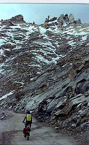
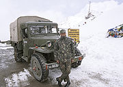
Khardung La is situated 39 km by road from Leh. The first 24 km, as far as the South Pullu check point, are paved. From there to the North Pullu check point about 15 km beyond the pass the roadway is primarily loose rock, dirt, and occasional rivulets of snow melt. However, this pass is in better repair than many of the surrounding passes (Tanglang La, for example). From North Pullu into the Nubra Valley, the road is very well maintained (except in a very few places where washouts or falling rock occur). Hired vehicles (2 and 4-wheel-drive), heavy truckTruck
A truck or lorry is a motor vehicle designed to transport cargo. Trucks vary greatly in size, power, and configuration, with the smallest being mechanically similar to an automobile...
s, and motorcycle
Motorcycle
A motorcycle is a single-track, two-wheeled motor vehicle. Motorcycles vary considerably depending on the task for which they are designed, such as long distance travel, navigating congested urban traffic, cruising, sport and racing, or off-road conditions.Motorcycles are one of the most...
s regularly travel into the Nubra Valley, though special permits may need to be arranged for travellers to make the journey.
Elevation
SK-42 Reference System
The SK-42 reference system also known as the Krasovsky ellipsoid, is a coordinate system established in the Soviet Union in 1942 as Systema koordinat , and provides parameters which are linked to the geocentric Cartesian coordinate system PZ-90...
mapping, and it is broadly consistent with several other independent travellers' GPS reports and an article by Bonington.
Several of these sources contain assertions by local people who claim that the 5,602 m (18,380 feet) height claimed by the summit signs has been inflated for the purpose of record breaking. The even higher elevation of 5,682 m (18,640 feet) that has been claimed by Guinness World Records
Guinness World Records
Guinness World Records, known until 2000 as The Guinness Book of Records , is a reference book published annually, containing a collection of world records, both human achievements and the extremes of the natural world...
and the National Geographic Society
National Geographic Society
The National Geographic Society , headquartered in Washington, D.C. in the United States, is one of the largest non-profit scientific and educational institutions in the world. Its interests include geography, archaeology and natural science, the promotion of environmental and historical...
is not supported by any evidence and may be rooted in a copying error from 5,602 m.
The world's highest motorable pass?
Semo La
Semo La is a mountain pass situated in the central part of Tibet and gives access to the Chang Tang region. It is found on the so-called Northern Route, north of Raka and south of Coqen in Central Tibet...
5,565 m (18,258 feet), between Raka and Coqen in Central Tibet
Tibet
Tibet is a plateau region in Asia, north-east of the Himalayas. It is the traditional homeland of the Tibetan people as well as some other ethnic groups such as Monpas, Qiang, and Lhobas, and is now also inhabited by considerable numbers of Han and Hui people...
. Both these elevations are supported by GPS and SRTM evidence and the latter was also measured by the Spanish
Spain
Spain , officially the Kingdom of Spain languages]] under the European Charter for Regional or Minority Languages. In each of these, Spain's official name is as follows:;;;;;;), is a country and member state of the European Union located in southwestern Europe on the Iberian Peninsula...
and supported by the Cartographic Institute of Catalonia. Vehicles have been driven over the 5582 metres (18,314 ft) Marsimik La
Marsimik La
Marsimik La or Marsimek La, elevation , is a high mountain pass in the Chang-Chemno Range in northern India about east of Leh, further by road...
, in the Indian Karakoram to the north-east of Khardung La, but it is debatable whether this pass should be considered to be motorable.
Getting to Khardung La Pass
Ladakh
Ladakh is a region of Jammu and Kashmir, the northernmost state of the Republic of India. It lies between the Kunlun mountain range in the north and the main Great Himalayas to the south, inhabited by people of Indo-Aryan and Tibetan descent...
. Leh is connected by road from Manali and Srinagar, and daily flights are operated from Delhi. From Leh, a daily bus service to Nubra Valley
Nubra Valley
Nubra Valley is about 150 km north of Leh, the capital town of Ladakh, India. Local scholars say that its original name was Ldumra . The Shyok River meets the Nubra or Siachan River to form a large valley that separates the Ladakh and the Karakoram Ranges. The average altitude of the valley is...
passes over Khardungla. The ideal method to get to Khardung-la is by taxi
Taxicab
A taxicab, also taxi or cab, is a type of vehicle for hire with a driver, used by a single passenger or small group of passengers, often for a non-shared ride. A taxicab conveys passengers between locations of their choice...
or bike
Bicycle
A bicycle, also known as a bike, pushbike or cycle, is a human-powered, pedal-driven, single-track vehicle, having two wheels attached to a frame, one behind the other. A person who rides a bicycle is called a cyclist, or bicyclist....
. Taking an experienced driver with you is advisable. The two bases on either side of Khardong-la are North Pullu and South Pullu. Inner Line Permit (ILP) is not needed to reach Khardung La peak, however Inner Line Permit is needed to cross North Pullu to reach Nubra Valley. Inner line permit can be procured at the DC's office in Leh. Travelers must provide photocopies of the permits, to be deposited at each checkpoint.
External links
- Riding in Ladakh/Motorcycling FAQ
- Documentary on Marsimek-La, highest motorable pass
- A Firsthand Experience
- Document supplied by the Cartographic Institute of Catalonia
- Local SRTM data
- Extract from 100K Russian Topographic map. Confusingly, this shows "Khardung" (in Cyrillic) further east, but the road pass is accurately mapped.
- Photo gallery of Khardung La, 1280x960
- Khardung La Pass, travelogue and pictures.