
Geography of Cuba
Encyclopedia
Cuba is an island nation
in the Caribbean Sea
. Cuba
has a total area of 110860 km² (42,803.3 sq mi). It has 3735 km (2,320.8 mi) of coastline and 29 km (18 mi) of land borders — all figures including the United States territory
at Guantánamo Bay, where the U.S. Navy's
Guantanamo Bay Naval Base
is located.
Cuba lies west of the North Atlantic Ocean
, east of the Gulf of Mexico
, south of the Straits of Florida
, northwest of the Windward Passage
, and northeast of the Yucatan Channel
. The main island (Cuba) makes up most of the land area 105006 km² (40,543 sq mi). The island is 1199 km (745 mi) long and 200 km (124.3 mi) across its widest points and 35 km (21.7 mi) across its narrowest points. The largest island outside the main island is the Isla de la Juventud (Isle of Youth) in the southwest, with an area of 3056 km² (1,179.9 sq mi).
 Cuba is located 80 km (49.7 mi) west of Haiti
across the Windward Passage
, 140 km (87 mi) south of the Bahamas, 145 km (90.1 mi) south of Florida
, 210 km (130.5 mi) east of Mexico
, and 146 km (90.7 mi) north of Jamaica
.
Cuba is the largest country by land area in the Caribbean. Its main island is the seventeenth-largest island in the world by land area. The island rises between the Atlantic Ocean
and the Caribbean Sea
. It is bordered on the north by the Straits of Florida
, on the northeast by Nicholas Channel
and the Old Bahamas Channel. The southern part is bounded by the Windward Passage
and the Cayman Trench, while the southwest lies in the Caribbean Sea. To the west, it reaches to the Yucatan Channel
, and the northwest is open to the Gulf of Mexico
.
More than 4,000 islands and cay
s are found in the surrounding sea and bays. The southern coast includes such archipelago
s as Jardines de la Reina
and the Canarreos. The northeastern shore is lined by the Sabana-Camagüey Archipelago
, which includes Jardines del Rey
and is composed of approximately 2,517 cays and islands. The Colorados Archipelago
is developed on the north-western coast.
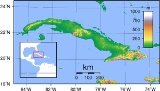
 Terrain is mostly flat to rolling plains, with rugged hills and mountains in the southeast. The lowest point is the Caribbean Sea at 0 m (sea level
) and the highest point is Pico Turquino
at 2005 m (6,578.1 ft), part of the Sierra Maestra
mountain range, located in the southeast of the island. Other significant mountain ranges are Sierra Cristal
in the southeast, Escambray Mountains
in the center of the island, and Sierra del Rosario
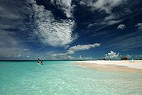
in the northwest. White sand beaches (most notably in Varadero
), as well as mangrove
s and marshes can be found in the coastal area. The largest is the Zapata Swamp
, with over 4520 km² (1,745.2 sq mi).
Cuba has negligible inland water area. The largest natural water mirror is Laguna de Leche
at 67.2 km² (25.9 sq mi), while the man-made Zaza Reservoir
, at 113.5 km² (43.8 sq mi), is the largest inland water surface by area in the country.
of 200 nmi (370.4 km; 230.2 mi).
 Extreme points in Cuba are:
Natural resource
s include cobalt
, nickel
, iron ore, copper
, manganese
, salt
, timber
, silica, and petroleum
. At one time, the whole island was covered with forests and there are still many cedar (Cedrela odorata
), chechem (Metopium brownei
), mahogany (Swietenia mahagoni
), and other valuable trees. Large areas were cleared to grow more sugarcane
, and so few trees remained that timber had to be imported.
The most important Cuban mineral economic resource is nickel
. Cuba has the second largest nickel reserves in the world after Russia. Sherritt International
, a Canadian energy company, operates a large nickel mining facility in Moa, Cuba
. Another leading mineral resource is cobalt
, a byproduct of nickel mining operations. Cuba ranks as the fifth largest producer of refined cobalt in the world.
Petroleum
is extracted on Cuba's northern shore, in the provinces of La Habana
and Matanzas
. Recent petroleum exploration has revealed that the North Cuba Basin could produce approximately 4.6 Goilbbl to 9.3 Goilbbl of petroleum. As of 2006, Cuba has now started to test-drill these locations for possible exploitation. The petroleum is of low quality, and used for energy generation only.
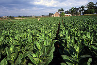
Sugarcane was the most important part of the economy in Cuba's history, and is still grown on large areas. Extensive irrigation
systems are developed in the south of Sancti Spíritus Province
. Tobacco
, used for some of the world's best cigars, is grown especially in the Pinar del Río Province
.
s. The dry season
lasts from November to April and the rainy season
from May to October.
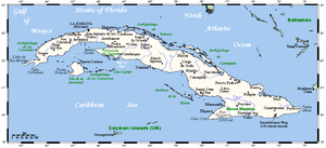
Cuba is an archipelago
of islands located in the Caribbean Sea, with the geographic coordinates 21°3N, 80°00W. Cuba is the principal island, which is surrounded by four main groups of islands. These are the Colorados
, the Sabana-Camagüey
, the Jardines de la Reina
and the Canarreos. The main island of Cuba constitutes most of the nation's land area or 105006 km² (40,543 sq mi) and is the seventeenth-largest island in the world by land area. The second largest island in Cuba is the Isla de la Juventud (Isle of Youth) in the southwest, with an area of 3056 km² (1,179.9 sq mi). Cuba has a total land area of 110860 km² (42,803.3 sq mi).
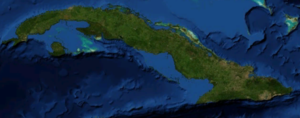
The main island consists mostly of flat to rolling plains. At the southeastern end is the Sierra Maestra
, a range of steep mountains whose highest point is the Pico Real del Turquino at 1975 metres (6,479.7 ft). The local climate
is tropical, though moderated by trade winds. In general (with local variations), there is a drier season from November to April, and a rainier season from May to October. The average temperature is 23.1 °C (73.6 °F) in January and 27 °C (80.6 °F) in July. Cuba lies in the path of hurricanes, and these destructive storms are most common in September and October. Havana
is the largest city and capital; other major cities include Santiago de Cuba
and Camagüey
. Better known smaller towns include Baracoa
which was the first Spanish settlement on Cuba, Trinidad
, a UNESCO world heritage site, and Bayamo
.
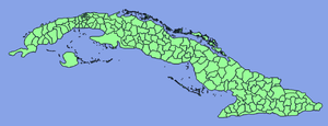
Cuba is divided into 15 Provinces
and one special municipality (Isla de la Juventud). The provinces are further subdivided into level 3 subdivisions, called municipalities
, of which there are 169 following the 1976 administrative redistribution.
Island nation
An island country is a state whose primary territory consists of one or more islands or parts of islands. As of 2011, 47 of the 193 UN member states are island countries.-Politics:...
in the Caribbean Sea
Caribbean Sea
The Caribbean Sea is a sea of the Atlantic Ocean located in the tropics of the Western hemisphere. It is bounded by Mexico and Central America to the west and southwest, to the north by the Greater Antilles, and to the east by the Lesser Antilles....
. Cuba
Cuba
The Republic of Cuba is an island nation in the Caribbean. The nation of Cuba consists of the main island of Cuba, the Isla de la Juventud, and several archipelagos. Havana is the largest city in Cuba and the country's capital. Santiago de Cuba is the second largest city...
has a total area of 110860 km² (42,803.3 sq mi). It has 3735 km (2,320.8 mi) of coastline and 29 km (18 mi) of land borders — all figures including the United States territory
United States territory
United States territory is any extent of region under the jurisdiction of the federal government of the United States, including all waters including all U.S. Naval carriers. The United States has traditionally proclaimed the sovereign rights for exploring, exploiting, conserving, and managing its...
at Guantánamo Bay, where the U.S. Navy's
United States Navy
The United States Navy is the naval warfare service branch of the United States Armed Forces and one of the seven uniformed services of the United States. The U.S. Navy is the largest in the world; its battle fleet tonnage is greater than that of the next 13 largest navies combined. The U.S...
Guantanamo Bay Naval Base
Guantanamo Bay Naval Base
Guantanamo Bay Naval Base is located on of land and water at Guantánamo Bay, Cuba which the United States leased for use as a coaling station following the Cuban-American Treaty of 1903. The base is located on the shore of Guantánamo Bay at the southeastern end of Cuba. It is the oldest overseas...
is located.
Cuba lies west of the North Atlantic Ocean
Atlantic Ocean
The Atlantic Ocean is the second-largest of the world's oceanic divisions. With a total area of about , it covers approximately 20% of the Earth's surface and about 26% of its water surface area...
, east of the Gulf of Mexico
Gulf of Mexico
The Gulf of Mexico is a partially landlocked ocean basin largely surrounded by the North American continent and the island of Cuba. It is bounded on the northeast, north and northwest by the Gulf Coast of the United States, on the southwest and south by Mexico, and on the southeast by Cuba. In...
, south of the Straits of Florida
Straits of Florida
The Straits of Florida, Florida Straits, or Florida Strait is a strait located south-southeast of the North American mainland, generally accepted to be between the Gulf of Mexico and the Atlantic Ocean, and between the Florida Keys and Cuba. The strait carries the Florida Current, the beginning of...
, northwest of the Windward Passage
Windward Passage
The Windward Passage is a strait in the Caribbean Sea, between the islands of Cuba and Hispaniola. The strait specifically lies between the easternmost region of Cuba and the northwest of Haiti.80km wide, the Windward Passage has a threshold depth of 1,700m...
, and northeast of the Yucatan Channel
Yucatán Channel
The Yucatán Channel is a strait between Mexico and Cuba. It connects the Yucatán Basin of the Caribbean Sea with the Gulf of Mexico. The strait is across between Cape Catoche in Mexico and Cape San Antonio, Cuba and reaches a maximum depth of .-References:...
. The main island (Cuba) makes up most of the land area 105006 km² (40,543 sq mi). The island is 1199 km (745 mi) long and 200 km (124.3 mi) across its widest points and 35 km (21.7 mi) across its narrowest points. The largest island outside the main island is the Isla de la Juventud (Isle of Youth) in the southwest, with an area of 3056 km² (1,179.9 sq mi).
Physical geography
Haiti
Haiti , officially the Republic of Haiti , is a Caribbean country. It occupies the western, smaller portion of the island of Hispaniola, in the Greater Antillean archipelago, which it shares with the Dominican Republic. Ayiti was the indigenous Taíno or Amerindian name for the island...
across the Windward Passage
Windward Passage
The Windward Passage is a strait in the Caribbean Sea, between the islands of Cuba and Hispaniola. The strait specifically lies between the easternmost region of Cuba and the northwest of Haiti.80km wide, the Windward Passage has a threshold depth of 1,700m...
, 140 km (87 mi) south of the Bahamas, 145 km (90.1 mi) south of Florida
Florida
Florida is a state in the southeastern United States, located on the nation's Atlantic and Gulf coasts. It is bordered to the west by the Gulf of Mexico, to the north by Alabama and Georgia and to the east by the Atlantic Ocean. With a population of 18,801,310 as measured by the 2010 census, it...
, 210 km (130.5 mi) east of Mexico
Mexico
The United Mexican States , commonly known as Mexico , is a federal constitutional republic in North America. It is bordered on the north by the United States; on the south and west by the Pacific Ocean; on the southeast by Guatemala, Belize, and the Caribbean Sea; and on the east by the Gulf of...
, and 146 km (90.7 mi) north of Jamaica
Jamaica
Jamaica is an island nation of the Greater Antilles, in length, up to in width and 10,990 square kilometres in area. It is situated in the Caribbean Sea, about south of Cuba, and west of Hispaniola, the island harbouring the nation-states Haiti and the Dominican Republic...
.
Cuba is the largest country by land area in the Caribbean. Its main island is the seventeenth-largest island in the world by land area. The island rises between the Atlantic Ocean
Atlantic Ocean
The Atlantic Ocean is the second-largest of the world's oceanic divisions. With a total area of about , it covers approximately 20% of the Earth's surface and about 26% of its water surface area...
and the Caribbean Sea
Caribbean Sea
The Caribbean Sea is a sea of the Atlantic Ocean located in the tropics of the Western hemisphere. It is bounded by Mexico and Central America to the west and southwest, to the north by the Greater Antilles, and to the east by the Lesser Antilles....
. It is bordered on the north by the Straits of Florida
Straits of Florida
The Straits of Florida, Florida Straits, or Florida Strait is a strait located south-southeast of the North American mainland, generally accepted to be between the Gulf of Mexico and the Atlantic Ocean, and between the Florida Keys and Cuba. The strait carries the Florida Current, the beginning of...
, on the northeast by Nicholas Channel
Nicholas Channel
Nicholas Channel is a strait off the northwestern coast of Cuba. It lies east of Havana. It separates Cuba from the most southwestern of the islands of the Bahamas....
and the Old Bahamas Channel. The southern part is bounded by the Windward Passage
Windward Passage
The Windward Passage is a strait in the Caribbean Sea, between the islands of Cuba and Hispaniola. The strait specifically lies between the easternmost region of Cuba and the northwest of Haiti.80km wide, the Windward Passage has a threshold depth of 1,700m...
and the Cayman Trench, while the southwest lies in the Caribbean Sea. To the west, it reaches to the Yucatan Channel
Yucatán Channel
The Yucatán Channel is a strait between Mexico and Cuba. It connects the Yucatán Basin of the Caribbean Sea with the Gulf of Mexico. The strait is across between Cape Catoche in Mexico and Cape San Antonio, Cuba and reaches a maximum depth of .-References:...
, and the northwest is open to the Gulf of Mexico
Gulf of Mexico
The Gulf of Mexico is a partially landlocked ocean basin largely surrounded by the North American continent and the island of Cuba. It is bounded on the northeast, north and northwest by the Gulf Coast of the United States, on the southwest and south by Mexico, and on the southeast by Cuba. In...
.
More than 4,000 islands and cay
Cay
A cay , also spelled caye or key, is a small, low-elevation, sandy island formed on the surface of coral reefs. Cays occur in tropical environments throughout the Pacific, Atlantic and Indian Oceans , where they provide habitable and agricultural land for hundreds of thousands of people...
s are found in the surrounding sea and bays. The southern coast includes such archipelago
Archipelago
An archipelago , sometimes called an island group, is a chain or cluster of islands. The word archipelago is derived from the Greek ἄρχι- – arkhi- and πέλαγος – pélagos through the Italian arcipelago...
s as Jardines de la Reina
Jardines de la Reina
Jardines de la Reina is an archipelago in the southern part of Cuba, in the provinces of Camagüey and Ciego de Ávila.It was named by Christopher Columbus to honour the Queen of Spain. Jardines de la Reina was established as a national park...
and the Canarreos. The northeastern shore is lined by the Sabana-Camagüey Archipelago
Sabana-Camaguey Archipelago
Sabana-Camagüey is an archipelago that lines Cuba's north-central Atlantic coast. It is located off the northern coast of the provinces of Matanzas, Villa Clara, Sancti Spíritus, Ciego de Ávila and Camagüey, and is bounded to the north by the Atlantic Ocean, specifically by the Nicholas Channel ...
, which includes Jardines del Rey
Jardines del Rey
Jardines del Rey is an archipelago located off the northern coast of the island of Cuba, in the northern parts of the provinces of Ciego de Ávila and Camagüey. It is developed on the coral reef system that lines Cuba's shore, between the Atlantic and the Bay of Buena Vista and Bay of Jiguey...
and is composed of approximately 2,517 cays and islands. The Colorados Archipelago
Colorados Archipelago
The Colorados Archipelago is a chain of isles and cays on Cuba's north-western coast.The sea surrounding the islands is used mainly for fishing, with commercial captures of lobster, sponge, oysters, red snapper and tuna...
is developed on the north-western coast.
Terrain
Sea level
Mean sea level is a measure of the average height of the ocean's surface ; used as a standard in reckoning land elevation...
) and the highest point is Pico Turquino
Pico Turquino
Pico Turquino is the highest point in Cuba. It is located in the southeast part of the island, in the Sierra Maestra mountain range in Santiago de Cuba Province....
at 2005 m (6,578.1 ft), part of the Sierra Maestra
Sierra Maestra
Sierra Maestra is a mountain range that runs westward across the south of the old Oriente Province from what is now Guantánamo Province to Niquero in southeast Cuba, rising abruptly from the coast. Some view it as a series of connecting ranges , which joins with others extending to the west...
mountain range, located in the southeast of the island. Other significant mountain ranges are Sierra Cristal
Sierra Cristal National Park
Sierra Cristal National Park is a national park in Cuba. It is located in the municipalities of Mayarí and Sagua de Tánamo in southern Holguín Province. It was the first National Park created in Cuba in 1930, and covers an area of ....
in the southeast, Escambray Mountains
Escambray Mountains
The Escambray Mountains are a mountain range in the central region of Cuba, in the provinces of Sancti Spíritus, Cienfuegos and Villa Clara....
in the center of the island, and Sierra del Rosario
Sierra del Rosario
Sierra del Rosario is mountain range in the Pinar del Río Province of Cuba. It is located in the western part of the Guaniguanico Range, in the north-central part of the province, between the municipalities of La Palma, Los Palacios and Consolación del Sur....
in the northwest. White sand beaches (most notably in Varadero
Varadero
Varadero is a resort town in the province of Matanzas, Cuba, and one of the largest resort areas in the Caribbean. Varadero is also called Playa Azul, which means "blue beach" in Spanish.-Geography:...
), as well as mangrove
Mangrove
Mangroves are various kinds of trees up to medium height and shrubs that grow in saline coastal sediment habitats in the tropics and subtropics – mainly between latitudes N and S...
s and marshes can be found in the coastal area. The largest is the Zapata Swamp
Zapata Swamp
Zapata Swamp is located on the Zapata Peninsula in the southern Matanzas province of Cuba. It is located less than southeast of Havana.-Species and preservation:...
, with over 4520 km² (1,745.2 sq mi).
Cuba has negligible inland water area. The largest natural water mirror is Laguna de Leche
Laguna de Leche
Laguna de Leche is the largest natural fresh water lake in Cuba. It is located in the wetland of northern Ciego de Ávila Province, north of Morón, and has a total surface of...
at 67.2 km² (25.9 sq mi), while the man-made Zaza Reservoir
Zaza Reservoir
Zaza Reservoir is the largest man-made reservoir in Cuba. It is located in the Sancti Spíritus Province in central Cuba, south-east of the city of Sancti Spíritus and north-west of La Sierpe. It has a water mirror area of...
, at 113.5 km² (43.8 sq mi), is the largest inland water surface by area in the country.
Maritime claims
Cuba makes maritime claims that include a territorial sea of 12 nmi (22.2 km; 13.8 mi) and an exclusive economic zoneExclusive Economic Zone
Under the law of the sea, an exclusive economic zone is a seazone over which a state has special rights over the exploration and use of marine resources, including production of energy from water and wind. It stretches from the seaward edge of the state's territorial sea out to 200 nautical...
of 200 nmi (370.4 km; 230.2 mi).
Extreme points
| Point | Name | Location | Remarks |
|---|---|---|---|
| North (on-shore) | Punta Hicacos | 23°12′23"N 81°08′44"W | On Hicacos Peninsula Hicacos Peninsula Hicacos is a peninsula on Cuba's northern shore, in the province of Matanzas. The resort town of Varadero is located on the peninsula. The name comes from a species of cactus.-Geography:... |
| North (off-shore) | Cayo Cruz del Padre | 23°16′34"N 80°54′38"W | Part of Sabana-Camaguey Archipelago Sabana-Camaguey Archipelago Sabana-Camagüey is an archipelago that lines Cuba's north-central Atlantic coast. It is located off the northern coast of the provinces of Matanzas, Villa Clara, Sancti Spíritus, Ciego de Ávila and Camagüey, and is bounded to the north by the Atlantic Ocean, specifically by the Nicholas Channel ... |
| East | Punta Maisi | 20°12′32"N 74°08′01"W | Near Maisí Maisí, Cuba Maisí is a municipality and town in the Guantánamo Province of Cuba.The easternmost point of Cuba, Punta Maisí is located in this municipality.-Demographics:... |
| West siders | Cape San Antonio | 21°51′39"N 84°57′25"W | On Guanahacabibes Peninsula Guanahacabibes Peninsula Guanahacabibes Peninsula is the westernmost point on the island of Cuba. It is located in Pinar del Río Province, in the municipality of Sandino and is sparsely populated. The waters surrounding the peninsula are important spiny lobster and red snapper fishing grounds. It also boasts the category... |
| South siders | Cape Cruz | 19°49′37"N 77°40′30"W | Near Niquero Niquero, Cuba Niquero is a municipality and city in the Granma Province of Cuba. It is located in the coastal region of the province, bordering the Gulf of Guacanayabo... |
| Highest point | Pico Turquino Pico Turquino Pico Turquino is the highest point in Cuba. It is located in the southeast part of the island, in the Sierra Maestra mountain range in Santiago de Cuba Province.... |
19°59′22"N 76°50′09"W | Part of Sierra Maestra Sierra Maestra Sierra Maestra is a mountain range that runs westward across the south of the old Oriente Province from what is now Guantánamo Province to Niquero in southeast Cuba, rising abruptly from the coast. Some view it as a series of connecting ranges , which joins with others extending to the west... , 1975 m (6,479.7 ft) |
| Lowest point | sea level Sea level Mean sea level is a measure of the average height of the ocean's surface ; used as a standard in reckoning land elevation... |
Caribbean Sea Caribbean Sea The Caribbean Sea is a sea of the Atlantic Ocean located in the tropics of the Western hemisphere. It is bounded by Mexico and Central America to the west and southwest, to the north by the Greater Antilles, and to the east by the Lesser Antilles.... and Atlantic Ocean Atlantic Ocean The Atlantic Ocean is the second-largest of the world's oceanic divisions. With a total area of about , it covers approximately 20% of the Earth's surface and about 26% of its water surface area... |
|
| Largest city | Havana Havana Havana is the capital city, province, major port, and leading commercial centre of Cuba. The city proper has a population of 2.1 million inhabitants, and it spans a total of — making it the largest city in the Caribbean region, and the most populous... |
23°08′00"N 82°23′00"W | National capital, population 2,328,000 |
| Oldest city | Baracoa | 20°20′55"N 74°30′38"W | Founded in 1511 |
Natural resources
Natural resource
Natural resource
Natural resources occur naturally within environments that exist relatively undisturbed by mankind, in a natural form. A natural resource is often characterized by amounts of biodiversity and geodiversity existent in various ecosystems....
s include cobalt
Cobalt
Cobalt is a chemical element with symbol Co and atomic number 27. It is found naturally only in chemically combined form. The free element, produced by reductive smelting, is a hard, lustrous, silver-gray metal....
, nickel
Nickel
Nickel is a chemical element with the chemical symbol Ni and atomic number 28. It is a silvery-white lustrous metal with a slight golden tinge. Nickel belongs to the transition metals and is hard and ductile...
, iron ore, copper
Copper
Copper is a chemical element with the symbol Cu and atomic number 29. It is a ductile metal with very high thermal and electrical conductivity. Pure copper is soft and malleable; an exposed surface has a reddish-orange tarnish...
, manganese
Manganese
Manganese is a chemical element, designated by the symbol Mn. It has the atomic number 25. It is found as a free element in nature , and in many minerals...
, salt
Salt
In chemistry, salts are ionic compounds that result from the neutralization reaction of an acid and a base. They are composed of cations and anions so that the product is electrically neutral...
, timber
Timber
Timber may refer to:* Timber, a term common in the United Kingdom and Australia for wood materials * Timber, Oregon, an unincorporated community in the U.S...
, silica, and petroleum
Petroleum
Petroleum or crude oil is a naturally occurring, flammable liquid consisting of a complex mixture of hydrocarbons of various molecular weights and other liquid organic compounds, that are found in geologic formations beneath the Earth's surface. Petroleum is recovered mostly through oil drilling...
. At one time, the whole island was covered with forests and there are still many cedar (Cedrela odorata
Cedrela odorata
Cedrela odorata . The genus Cedrela has undergone two major systematic revisions since 1960. The most recent revision reduced the number of species in the genus to seven . The common cedro, Cedrela odorata L., embraces 28 other named species, including C. mexicana M. J...
), chechem (Metopium brownei
Metopium brownei
Metopium brownei is a species of plant in the Anacardiaceae family. It is found in the Dominican Republic, Cuba, Jamaica, northern Guatemala, Belize, and from the Yucatan to Veracruz in Mexico. The wood of this tree is a valuable source of lumber in Central America and the West Indies...
), mahogany (Swietenia mahagoni
Swietenia mahagoni
Swietenia mahagoni, commonly known as the West Indies Mahogany, is a species of Swietenia native to southern Florida, USA, The Bahamas, Cuba, Jamaica, and Hispaniola. It is the species from which the original mahogany wood was produced....
), and other valuable trees. Large areas were cleared to grow more sugarcane
Sugarcane
Sugarcane refers to any of six to 37 species of tall perennial grasses of the genus Saccharum . Native to the warm temperate to tropical regions of South Asia, they have stout, jointed, fibrous stalks that are rich in sugar, and measure two to six metres tall...
, and so few trees remained that timber had to be imported.
The most important Cuban mineral economic resource is nickel
Nickel
Nickel is a chemical element with the chemical symbol Ni and atomic number 28. It is a silvery-white lustrous metal with a slight golden tinge. Nickel belongs to the transition metals and is hard and ductile...
. Cuba has the second largest nickel reserves in the world after Russia. Sherritt International
Sherritt International
Sherritt International is a Canadian energy company, based in Toronto, Ontario. It is involved in nickel and cobalt mining, thermal coal production, oil and gas exploration and production, and electricity generation...
, a Canadian energy company, operates a large nickel mining facility in Moa, Cuba
Moa, Cuba
Moa is a municipality and city in the Holguín Province of Cuba.Large nickel deposits located in the Moa area are exploited in part by joint ventures with the Canadian company Sherritt International.-Demographics:...
. Another leading mineral resource is cobalt
Cobalt
Cobalt is a chemical element with symbol Co and atomic number 27. It is found naturally only in chemically combined form. The free element, produced by reductive smelting, is a hard, lustrous, silver-gray metal....
, a byproduct of nickel mining operations. Cuba ranks as the fifth largest producer of refined cobalt in the world.
Petroleum
Petroleum
Petroleum or crude oil is a naturally occurring, flammable liquid consisting of a complex mixture of hydrocarbons of various molecular weights and other liquid organic compounds, that are found in geologic formations beneath the Earth's surface. Petroleum is recovered mostly through oil drilling...
is extracted on Cuba's northern shore, in the provinces of La Habana
La Habana Province
Havana Province was one of the provinces of Cuba, prior to being divided into two new provinces of Artemisa and Mayabeque on January 1, 2011. It had 711,066 people in the 2002 census. The largest city was Artemisa .-Geography:...
and Matanzas
Matanzas Province
Matanzas is one of the provinces of Cuba. Major towns in the province include Cárdenas, Colón, Jovellanos and the capital of the same name, Matanzas...
. Recent petroleum exploration has revealed that the North Cuba Basin could produce approximately 4.6 Goilbbl to 9.3 Goilbbl of petroleum. As of 2006, Cuba has now started to test-drill these locations for possible exploitation. The petroleum is of low quality, and used for energy generation only.
Sugarcane was the most important part of the economy in Cuba's history, and is still grown on large areas. Extensive irrigation
Irrigation
Irrigation may be defined as the science of artificial application of water to the land or soil. It is used to assist in the growing of agricultural crops, maintenance of landscapes, and revegetation of disturbed soils in dry areas and during periods of inadequate rainfall...
systems are developed in the south of Sancti Spíritus Province
Sancti Spíritus Province
Sancti Spíritus is one of the provinces of Cuba. Its capital is the identically named Sancti Spíritus. Another major city is Trinidad.The southern coast of the province is flat, but the western portion of Sancti Spíritus province is mountainous. The southeast has numerous mangroves and swamps...
. Tobacco
Tobacco
Tobacco is an agricultural product processed from the leaves of plants in the genus Nicotiana. It can be consumed, used as a pesticide and, in the form of nicotine tartrate, used in some medicines...
, used for some of the world's best cigars, is grown especially in the Pinar del Río Province
Pinar del Río Province
Pinar del Río is one of the provinces of Cuba. It is at the western end of the island of Cuba.-Geography:The Pinar del Río province is Cuba's westernmost province and contains one of Cuba's three main mountain ranges, the Cordillera de Guaniguanico, divided into the easterly Sierra del Rosario and...
.
Climate
Cuba's climate is tropical and moderated by trade windTrade wind
The trade winds are the prevailing pattern of easterly surface winds found in the tropics, within the lower portion of the Earth's atmosphere, in the lower section of the troposphere near the Earth's equator...
s. The dry season
Dry season
The dry season is a term commonly used when describing the weather in the tropics. The weather in the tropics is dominated by the tropical rain belt, which oscillates from the northern to the southern tropics over the course of the year...
lasts from November to April and the rainy season
Wet season
The the wet season, or rainy season, is the time of year, covering one or more months, when most of the average annual rainfall in a region occurs. The term green season is also sometimes used as a euphemism by tourist authorities. Areas with wet seasons are dispersed across portions of the...
from May to October.
Cuba is an archipelago
Archipelago
An archipelago , sometimes called an island group, is a chain or cluster of islands. The word archipelago is derived from the Greek ἄρχι- – arkhi- and πέλαγος – pélagos through the Italian arcipelago...
of islands located in the Caribbean Sea, with the geographic coordinates 21°3N, 80°00W. Cuba is the principal island, which is surrounded by four main groups of islands. These are the Colorados
Colorados Archipelago
The Colorados Archipelago is a chain of isles and cays on Cuba's north-western coast.The sea surrounding the islands is used mainly for fishing, with commercial captures of lobster, sponge, oysters, red snapper and tuna...
, the Sabana-Camagüey
Sabana-Camaguey Archipelago
Sabana-Camagüey is an archipelago that lines Cuba's north-central Atlantic coast. It is located off the northern coast of the provinces of Matanzas, Villa Clara, Sancti Spíritus, Ciego de Ávila and Camagüey, and is bounded to the north by the Atlantic Ocean, specifically by the Nicholas Channel ...
, the Jardines de la Reina
Jardines de la Reina
Jardines de la Reina is an archipelago in the southern part of Cuba, in the provinces of Camagüey and Ciego de Ávila.It was named by Christopher Columbus to honour the Queen of Spain. Jardines de la Reina was established as a national park...
and the Canarreos. The main island of Cuba constitutes most of the nation's land area or 105006 km² (40,543 sq mi) and is the seventeenth-largest island in the world by land area. The second largest island in Cuba is the Isla de la Juventud (Isle of Youth) in the southwest, with an area of 3056 km² (1,179.9 sq mi). Cuba has a total land area of 110860 km² (42,803.3 sq mi).
The main island consists mostly of flat to rolling plains. At the southeastern end is the Sierra Maestra
Sierra Maestra
Sierra Maestra is a mountain range that runs westward across the south of the old Oriente Province from what is now Guantánamo Province to Niquero in southeast Cuba, rising abruptly from the coast. Some view it as a series of connecting ranges , which joins with others extending to the west...
, a range of steep mountains whose highest point is the Pico Real del Turquino at 1975 metres (6,479.7 ft). The local climate
Climate
Climate encompasses the statistics of temperature, humidity, atmospheric pressure, wind, rainfall, atmospheric particle count and other meteorological elemental measurements in a given region over long periods...
is tropical, though moderated by trade winds. In general (with local variations), there is a drier season from November to April, and a rainier season from May to October. The average temperature is 23.1 °C (73.6 °F) in January and 27 °C (80.6 °F) in July. Cuba lies in the path of hurricanes, and these destructive storms are most common in September and October. Havana
Havana
Havana is the capital city, province, major port, and leading commercial centre of Cuba. The city proper has a population of 2.1 million inhabitants, and it spans a total of — making it the largest city in the Caribbean region, and the most populous...
is the largest city and capital; other major cities include Santiago de Cuba
Santiago de Cuba
Santiago de Cuba is the second largest city of Cuba and capital city of Santiago de Cuba Province in the south-eastern area of the island, some south-east of the Cuban capital of Havana....
and Camagüey
Camagüey
Camagüey is a city and municipality in central Cuba and is the nation's third largest city. It is the capital of the Camagüey Province.After almost continuous attacks from pirates the original city was moved inland in 1528.The new city was built with a confusing lay-out of winding alleys that made...
. Better known smaller towns include Baracoa
Baracoa
Baracoa is a municipality and city in Guantánamo Province near the eastern tip of Cuba. It was founded by the first governor of Cuba, the Spanish conquistador Diego Velázquez de Cuéllar in 1511...
which was the first Spanish settlement on Cuba, Trinidad
Trinidad, Cuba
-External links:* , Online travel guide to Trinidad* , Selected photos of Trinidad* , Photos of Trinidad...
, a UNESCO world heritage site, and Bayamo
Bayamo
Bayamo is the capital city of the Granma Province of Cuba, and one of the largest cities in the Oriente region.The community of Bayamo lies on a plain by the Bayamon River...
.
Administrative subdivisions
Cuba is divided into 15 Provinces
Provinces of Cuba
Administratively, Cuba is divided into 15 provinces and one special municipality not included in any province. The last modification was approved in August 2010 , splitting Havana province into two new provinces: Artemisa and Mayabeque...
and one special municipality (Isla de la Juventud). The provinces are further subdivided into level 3 subdivisions, called municipalities
Municipalities of Cuba
The provinces of Cuba are divided into 169 municipalities or municipios. They were defined by Cuban Law Number 1304 of July 3, 1976.-Summary:The municipalities are listed below, by province:...
, of which there are 169 following the 1976 administrative redistribution.