
Sancti Spíritus Province
Encyclopedia
Sancti Spíritus is one of the provinces of Cuba
. Its capital is the identically named Sancti Spíritus
. Another major city is Trinidad
.
The southern coast of the province is flat, but the western portion of Sancti Spíritus province is mountain
ous. The southeast has numerous mangrove
s and swamp
s. The northern coast contains significant wetlands and protected areas such as the Bay of Buena Vista
and the Caguanes National Park
.
The largest man made reservoir in Cuba
, the Embalse Zaza, is in Sancti Spíritus province.
and British
pirates attempted to take control of what is today Sancti Spíritus province, but with little success, as the Spanish garrison held them off. From 1660 to 1680, Trinidad was plagued by pirates from Jamaica
and Tortuga, and on two occasions, pirates razed the city.
The provinces of Cienfuegos
, Sancti Spíritus, and Villa Clara
were once all part of the now defunct province of Las Villas.
is a big earner for the province, with most of the tourism centred around the old city of Trinidad, a World Heritage listed city which has dozens of colonial buildings (and almost no 20th century architecture) dating back to the Spanish
conquest in the 16th century.
Francisco Iznaga, a rich Basque landowner in the western portion of Cuba during the first 30 years of the colonization of Cuba, was elected Mayor of Bayamo in 1540. Iznaga was the originator of a powerful lineage that finally settled in Sancti Spiritus and Trinidad, the location of the Torre Iznaga. His descendants fought for the Independence of Cuba and the Annexation to the US from 1820 to 1900.
In the area, as with most of Cuba, sugarcane
and cattle
are important commodities. Large surfaces are irrigated
in the farmland between Zaza Reservoir
, Zaza River and Jatibonico River in La Sierpe
region. Some tobacco
and rice
is also grown.
Provinces of Cuba
Administratively, Cuba is divided into 15 provinces and one special municipality not included in any province. The last modification was approved in August 2010 , splitting Havana province into two new provinces: Artemisa and Mayabeque...
. Its capital is the identically named Sancti Spíritus
Sancti Spíritus
Sancti Spíritus is a municipality and capital city of the province of Sancti Spíritus in central Cuba. Sancti Spíritus, Latin for "Holy Spirit," is one of the best preserved cities in the Caribbean from the time of the sugar trade.-History:...
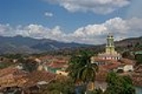
. Another major city is Trinidad
Trinidad, Cuba
-External links:* , Online travel guide to Trinidad* , Selected photos of Trinidad* , Photos of Trinidad...
.
The southern coast of the province is flat, but the western portion of Sancti Spíritus province is mountain
Mountain
Image:Himalaya_annotated.jpg|thumb|right|The Himalayan mountain range with Mount Everestrect 58 14 160 49 Chomo Lonzorect 200 28 335 52 Makalurect 378 24 566 45 Mount Everestrect 188 581 920 656 Tibetan Plateaurect 250 406 340 427 Rong River...
ous. The southeast has numerous mangrove
Mangrove
Mangroves are various kinds of trees up to medium height and shrubs that grow in saline coastal sediment habitats in the tropics and subtropics – mainly between latitudes N and S...
s and swamp
Swamp
A swamp is a wetland with some flooding of large areas of land by shallow bodies of water. A swamp generally has a large number of hammocks, or dry-land protrusions, covered by aquatic vegetation, or vegetation that tolerates periodical inundation. The two main types of swamp are "true" or swamp...
s. The northern coast contains significant wetlands and protected areas such as the Bay of Buena Vista
Bay of Buena Vista
The Bay of Buena Vista is a bay on Cuba's northern Atlantic shore. It is located in the northern part of the provinces of Sancti Spíritus, Villa Clara and Ciego de Ávila, between mainland Cuba and the archipelago that lines its northern coast....
and the Caguanes National Park
Caguanes National Park
Caguanes National Park is a national park in Cuba. It is located in the Yaguajay municipality in the northern part of Sancti Spíritus Province, on the northern coast of Cuba....
.
The largest man made reservoir in Cuba
Cuba
The Republic of Cuba is an island nation in the Caribbean. The nation of Cuba consists of the main island of Cuba, the Isla de la Juventud, and several archipelagos. Havana is the largest city in Cuba and the country's capital. Santiago de Cuba is the second largest city...
, the Embalse Zaza, is in Sancti Spíritus province.
History
During the 17th century, both DutchNetherlands
The Netherlands is a constituent country of the Kingdom of the Netherlands, located mainly in North-West Europe and with several islands in the Caribbean. Mainland Netherlands borders the North Sea to the north and west, Belgium to the south, and Germany to the east, and shares maritime borders...
and British
United Kingdom
The United Kingdom of Great Britain and Northern IrelandIn the United Kingdom and Dependencies, other languages have been officially recognised as legitimate autochthonous languages under the European Charter for Regional or Minority Languages...
pirates attempted to take control of what is today Sancti Spíritus province, but with little success, as the Spanish garrison held them off. From 1660 to 1680, Trinidad was plagued by pirates from Jamaica
Jamaica
Jamaica is an island nation of the Greater Antilles, in length, up to in width and 10,990 square kilometres in area. It is situated in the Caribbean Sea, about south of Cuba, and west of Hispaniola, the island harbouring the nation-states Haiti and the Dominican Republic...
and Tortuga, and on two occasions, pirates razed the city.
The provinces of Cienfuegos
Cienfuegos Province
Cienfuegos is one of the provinces of Cuba. The capital city of the province is also called Cienfuegos and was founded by French settlers in 1819....
, Sancti Spíritus, and Villa Clara
Villa Clara Province
Villa Clara is one of the provinces of Cuba. It is located in the central region of the island bordering with the Atlantic at north, Matanzas Province by west, Sancti Spiritus by east, and Cienfuegos on the South. Villa Clara shares with Cienfuegos and Sancti Spiritus on the south the Escambray...
were once all part of the now defunct province of Las Villas.
Economy
TourismTourism
Tourism is travel for recreational, leisure or business purposes. The World Tourism Organization defines tourists as people "traveling to and staying in places outside their usual environment for not more than one consecutive year for leisure, business and other purposes".Tourism has become a...
is a big earner for the province, with most of the tourism centred around the old city of Trinidad, a World Heritage listed city which has dozens of colonial buildings (and almost no 20th century architecture) dating back to the Spanish
Spain
Spain , officially the Kingdom of Spain languages]] under the European Charter for Regional or Minority Languages. In each of these, Spain's official name is as follows:;;;;;;), is a country and member state of the European Union located in southwestern Europe on the Iberian Peninsula...
conquest in the 16th century.
Francisco Iznaga, a rich Basque landowner in the western portion of Cuba during the first 30 years of the colonization of Cuba, was elected Mayor of Bayamo in 1540. Iznaga was the originator of a powerful lineage that finally settled in Sancti Spiritus and Trinidad, the location of the Torre Iznaga. His descendants fought for the Independence of Cuba and the Annexation to the US from 1820 to 1900.
In the area, as with most of Cuba, sugarcane
Sugarcane
Sugarcane refers to any of six to 37 species of tall perennial grasses of the genus Saccharum . Native to the warm temperate to tropical regions of South Asia, they have stout, jointed, fibrous stalks that are rich in sugar, and measure two to six metres tall...
and cattle
Cattle
Cattle are the most common type of large domesticated ungulates. They are a prominent modern member of the subfamily Bovinae, are the most widespread species of the genus Bos, and are most commonly classified collectively as Bos primigenius...
are important commodities. Large surfaces are irrigated
Irrigation
Irrigation may be defined as the science of artificial application of water to the land or soil. It is used to assist in the growing of agricultural crops, maintenance of landscapes, and revegetation of disturbed soils in dry areas and during periods of inadequate rainfall...
in the farmland between Zaza Reservoir
Zaza Reservoir
Zaza Reservoir is the largest man-made reservoir in Cuba. It is located in the Sancti Spíritus Province in central Cuba, south-east of the city of Sancti Spíritus and north-west of La Sierpe. It has a water mirror area of...
, Zaza River and Jatibonico River in La Sierpe
La Sierpe, Cuba
La Sierpe is a municipality and city in the Sancti Spíritus Province of Cuba. It is located in the south-eastern part of the province, from Sancti Spiritus, the provincial capital. It borders the Gulf of Ana Maria of the Caribbean Sea to the south and the province of Ciego de Ávila to the...
region. Some tobacco
Tobacco
Tobacco is an agricultural product processed from the leaves of plants in the genus Nicotiana. It can be consumed, used as a pesticide and, in the form of nicotine tartrate, used in some medicines...
and rice
Rice
Rice is the seed of the monocot plants Oryza sativa or Oryza glaberrima . As a cereal grain, it is the most important staple food for a large part of the world's human population, especially in East Asia, Southeast Asia, South Asia, the Middle East, and the West Indies...
is also grown.
Municipalities
| Municipality | Population (2004) | Area (km²) | Location | Remarks |
|---|---|---|---|---|
| Cabaiguán | 22°05′2"N 79°29′43"W | |||
| Fomento Fomento, Cuba Fomento is a municipality and city in the Sancti Spíritus Province of Cuba.The municipality is divided into the barrios of Fomento, Güinia de Miranda and Jíquimas.It was founded in 1864.... |
22°06′19"N 79°43′12"W | |||
| Jatibonico Jatibonico, Cuba -Demographics:In 2004, the municipality of Jatibonico had a population of 42,708. With a total area of , it has a population density of .-Catholic Parish Church:... |
21°56′47"N 79°10′3"W | |||
| La Sierpe La Sierpe, Cuba La Sierpe is a municipality and city in the Sancti Spíritus Province of Cuba. It is located in the south-eastern part of the province, from Sancti Spiritus, the provincial capital. It borders the Gulf of Ana Maria of the Caribbean Sea to the south and the province of Ciego de Ávila to the... |
21°45′39"N 79°14′36"W | |||
| Sancti Spíritus | 21°56′3"N 79°26′37"W | Provincial capital | ||
| Taguasco Taguasco, Cuba Taguasco is a municipality and city in the Sancti Spíritus Province of Cuba. It is located north-east of Sancti Spiritus, the provincial capital, and is bisected by Carretera Central highway between Cabaiguán and Jatibonico.-Demographics:... |
22°00′19"N 79°15′54"W | |||
| Trinidad Trinidad, Cuba -External links:* , Online travel guide to Trinidad* , Selected photos of Trinidad* , Photos of Trinidad... |
21°48′16"N 79°58′58"W | |||
| Yaguajay Yaguajay, Cuba Yaguajay is a municipality and city in the Sancti Spíritus Province of Cuba. It is located in the northern part of the province, and borders the Bay of Buena Vista to the north.... |
22°19′50"N 79°14′13"W |
- Source: Population from 2004 Census. Area from 1976 municipal re-distribution.