

Geography of Croatia
Encyclopedia
Croatia
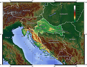
Croatia , officially the Republic of Croatia , is a unitary democratic parliamentary republic in Europe at the crossroads of the Mitteleuropa, the Balkans, and the Mediterranean. Its capital and largest city is Zagreb. The country is divided into 20 counties and the city of Zagreb. Croatia covers ...
in the Southeast Europe
Southeast Europe
Southeast Europe or Southeastern Europe is a relatively recent political designation for the states of the Balkans. Writers such as Maria Todorova and Vesna Goldsworthy have suggested the use of the term Southeastern Europe to replace the word Balkans for the region, to minimize potential...
, bordering Bosnia and Herzegovina and Serbia in the east, Slovenia
Slovenia
Slovenia , officially the Republic of Slovenia , is a country in Central and Southeastern Europe touching the Alps and bordering the Mediterranean. Slovenia borders Italy to the west, Croatia to the south and east, Hungary to the northeast, and Austria to the north, and also has a small portion of...
in the west, Hungary
Hungary
Hungary , officially the Republic of Hungary , is a landlocked country in Central Europe. It is situated in the Carpathian Basin and is bordered by Slovakia to the north, Ukraine and Romania to the east, Serbia and Croatia to the south, Slovenia to the southwest and Austria to the west. The...
in the north and Montenegro
Montenegro
Montenegro Montenegrin: Crna Gora Црна Гора , meaning "Black Mountain") is a country located in Southeastern Europe. It has a coast on the Adriatic Sea to the south-west and is bordered by Croatia to the west, Bosnia and Herzegovina to the northwest, Serbia to the northeast and Albania to the...
and the Adriatic Sea
Adriatic Sea
The Adriatic Sea is a body of water separating the Italian Peninsula from the Balkan peninsula, and the system of the Apennine Mountains from that of the Dinaric Alps and adjacent ranges...
in the south. It lies mostly between latitudes 42°
42nd parallel north
The 42nd parallel north is a circle of latitude that is 42 degrees north of the Earth's equatorial plane. It crosses Europe, the Mediterranean Sea, Asia, the Pacific Ocean, North America, and the Atlantic Ocean....
and 47° N
47th parallel north
The 47th parallel north is a circle of latitude that is 47 degrees north of the Earth's equatorial plane. It crosses Europe, Asia, the Pacific Ocean, North America, and the Atlantic Ocean....
and longitudes 13°
13th meridian east
The meridian 13° east of Greenwich is a line of longitude that extends from the North Pole across the Arctic Ocean, Europe, Africa, the Atlantic Ocean, the Southern Ocean, and Antarctica to the South Pole....
and 20° E
20th meridian east
The meridian 20° east of Greenwich is a line of longitude that extends from the North Pole across the Arctic Ocean, Europe, Africa, the Atlantic and Indian oceans, the Southern Ocean, and Antarctica to the South Pole....
. Part of the territory in the extreme south is separated from the rest of the mainland by a short coastline strip belonging to Bosnia and Herzegovina around Neum
Neum
Neum is the only coastal town in Bosnia and Herzegovina. It comprises of coastline, the country's only access to the Adriatic Sea. As of 2009, municipal population was of 4,605 and the one of Neum main town was of 4,268 .-Features:Neum has steep hills, sandy beaches, and several large tourist...
.
The territory covers 56594 square kilometres (21,851 sq mi), consisting of 56414 square kilometres (21,782 sq mi) of land and 128 square kilometres (49 sq mi) of water. It is the 127th largest country largest in the world. Elevation ranges from the mountains of the Dinaric Alps
Dinaric Alps
The Dinaric Alps or Dinarides form a mountain chain in Southern Europe, spanning areas of Slovenia, Croatia, Bosnia and Herzegovina, Serbia, Kosovo, Albania and Montenegro....
with the highest point of the Dinara
Dinara
Dinara is a mountain located on the border of Croatia and Bosnia and Herzegovina. One of its summits, also called Dinara, is the highest point in Croatia at 1,831 m and a prominence of 728 m.-Etymology:...
peak at 1831 metres (6,007.2 ft) near the border with Bosnia and Herzegovina in the south to the shore of the Adriatic Sea which makes up its entire south-west border. Insular Croatia consists of over a thousand islands and islets varying in size, 48 of which are permanently inhabited. The largest islands are Cres
Cres
Cres is an Adriatic island in Croatia. It is one of the northern island in the Kvarner Gulf and can be reached via ferry from the island Krk or from the Istrian peninsula ....
and Krk
Krk
Krk is a Croatian island in the northern Adriatic Sea, located near Rijeka in the Bay of Kvarner and part of the Primorje-Gorski Kotar county....
, each of them having an area of around 405 km2.
The hilly northern parts of Hrvatsko Zagorje
Hrvatsko Zagorje
Hrvatsko Zagorje is a region north of Zagreb, Croatia. It comprises the whole area north of Medvednica mountain up to Slovenia in the north and west, and up to the regions of Međimurje and Podravina in the north and east...
and the flat plains of Slavonia
Slavonia
Slavonia is a geographical and historical region in eastern Croatia...
in the east (which is part of the Pannonian Basin
Pannonian Basin
The Pannonian Basin or Carpathian Basin is a large basin in East-Central Europe.The geomorphological term Pannonian Plain is more widely used for roughly the same region though with a somewhat different sense - meaning only the lowlands, the plain that remained when the Pliocene Pannonian Sea dried...
) are traversed by major rivers such as Sava, Drava
Drava
Drava or Drave is a river in southern Central Europe, a tributary of the Danube. It sources in Toblach/Dobbiaco, Italy, and flows east through East Tirol and Carinthia in Austria, into Slovenia , and then southeast, passing through Croatia and forming most of the border between Croatia and...
, Kupa
Kupa
Kupa may refer to:*Kupa River, a river in Croatia and Slovenia*Kupa River , a river in Lithuania*Kupa River in Siberia, see Kuta River*Kupa Synagogue, a synagogue in Krakow*Kupa, Hungary, a village in Northern Hungary...
and Danube
Danube
The Danube is a river in the Central Europe and the Europe's second longest river after the Volga. It is classified as an international waterway....
. The Danube, Europe's second longest river, runs through the city of Vukovar
Vukovar
Vukovar is a city in eastern Croatia, and the biggest river port in Croatia located at the confluence of the Vuka river and the Danube. Vukovar is the center of the Vukovar-Syrmia County...
in the extreme east and forms part of the border with Serbia. The central and southern regions near the Adriatic coastline and islands consist of low mountains and forested highlands. Significant natural resources include oil, coal, bauxite, low-grade iron ore, calcium, gypsum, natural asphalt, silica, mica, clays, salt and hydropower.
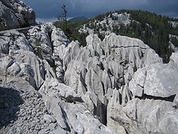
Karst topography
Karst topography
Karst topography is a geologic formation shaped by the dissolution of a layer or layers of soluble bedrock, usually carbonate rock such as limestone or dolomite, but has also been documented for weathering resistant rocks like quartzite given the right conditions.Due to subterranean drainage, there...
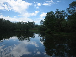
makes up about half of Croatia and is especially prominent in the Dinaric Alps. There are numerous caves in Croatia, 49 of which deeper than 250 m (820.21 ft), 14 deeper than 500 m (1,640.42 ft) and three deeper than 1000 m (3,280.84 ft). Croatia's most famous lakes are the Plitvice lakes, a system of 16 lakes with waterfalls connecting them over dolomite
Dolomite
Dolomite is a carbonate mineral composed of calcium magnesium carbonate CaMg2. The term is also used to describe the sedimentary carbonate rock dolostone....
and limestone
Limestone
Limestone is a sedimentary rock composed largely of the minerals calcite and aragonite, which are different crystal forms of calcium carbonate . Many limestones are composed from skeletal fragments of marine organisms such as coral or foraminifera....
cascades. The lakes are renowned for their distinctive colours, ranging from turquoise to mint green, grey or blue.
Climate
Most of Croatia has a moderately warm and rainy continental climateContinental climate
Continental climate is a climate characterized by important annual variation in temperature due to the lack of significant bodies of water nearby...
as defined by the Köppen climate classification
Köppen climate classification
The Köppen climate classification is one of the most widely used climate classification systems. It was first published by Crimea German climatologist Wladimir Köppen in 1884, with several later modifications by Köppen himself, notably in 1918 and 1936...
. Mean monthly temperature ranges between -3 °C (in January) and 18 °C (64.4 °F) (in July). The coldest parts of the country are Lika
Lika
Lika is a mountainous region in central Croatia, roughly bound by the Velebit mountain from the southwest and the Plješevica mountain from the northeast. On the north-west end Lika is bounded by Ogulin-Plaški basin, and on the south-east by the Malovan pass...
and Gorski Kotar
Gorski kotar
Gorski kotar is the mountainous region in Croatia between Karlovac and Rijeka. Together with Lika and the Ogulin-Plaški valley it forms Mountainous Croatia. Because 63% of its surface is forested it is popularly called the green lungs of Croatia or Croatian Switzerland...
where snowy forested climate is found at elevations above 1200 metres (3,937 ft). The warmest areas of Croatia are at the Adriatic coast and especially in its immediate hinterland characterized by the Mediterranean climate
Mediterranean climate
A Mediterranean climate is the climate typical of most of the lands in the Mediterranean Basin, and is a particular variety of subtropical climate...
, as the temperature highs are moderated by the sea. Consequently, temperature peaks are more pronounced in the continental areas—the lowest temperature of -35.5 °C was recorded on 3 February 1919 in Čakovec
Cakovec
Čakovec is a city in northern Croatia, located around 90 kilometres north of Zagreb, the Croatian capital. Čakovec is both the county seat and largest city of Međimurje County, the northernmost, smallest and most densely populated Croatian county.-Population:...
, and the highest temperature of 42.4 °C (108.3 °F) was recorded on 5 July 1950 in Karlovac
Karlovac
Karlovac is a city and municipality in central Croatia. The city proper has a population of 49,082, while the municipality has a population of 59,395 inhabitants .Karlovac is the administrative centre of Karlovac County...
.
Mean annual precipitation ranges between 600 millimetres (23.6 in) and 3500 millimetres (137.8 in) depending on geographic region and prevailing climate type. The least precipitation is recorded in the outer islands (Vis, Lastovo
Lastovo
Lastovo is an island municipality in the Dubrovnik-Neretva County in Croatia. The municipality consists of 46 islands with a total population of 792 people, of which 93% are ethnic Croats, and a land area of approximately . The biggest island in the municipality is also named Lastovo, as is the...
, Biševo
Biševo
Biševo is an island in the Adriatic Sea in Croatia. It is situated in the middle of the Dalmatian archipelago, five kilometers southwest of the Island of Vis. Its area is 5.8 km and it has a population of 11 . It is composed of limestone; the highest point is Straženica, 239 m high...
, Svetac) and in the eastern parts of Slavonia, however in the latter case, it is mostly occurring during the growing season
Growing season
In botany, horticulture, and agriculture the growing season is the period of each year when native plants and ornamental plants grow; and when crops can be grown....
. The maximum precipitation levels are observed on the Dinara mountain range and in Gorski kotar. Prevailing winds in the interior are light to moderate northeast or southwest, and in the coastal area prevailing winds are determined by local area features. Higher wind velocities are more often recorded in cooler months along the coast, generally as bura
Bora (wind)
Bora or Bura is a northern to north-eastern katabatic wind in the Adriatic, Bosnia and Herzegovina, Croatia, Montenegro, Italy, Greece, Slovenia, and Turkey....
or less frequently as sirocco
Sirocco
Sirocco, scirocco, , jugo or, rarely, siroc is a Mediterranean wind that comes from the Sahara and reaches hurricane speeds in North Africa and Southern Europe. It is known in North Africa by the Arabic word qibli or ghibli Sirocco, scirocco, , jugo or, rarely, siroc is a Mediterranean wind...
. The sunniest parts of the country are the outer islands, Hvar and Korčula
Korcula
Korčula is an island in the Adriatic Sea, in the Dubrovnik-Neretva County of Croatia. The island has an area of ; long and on average wide — and lies just off the Dalmatian coast. Its 16,182 inhabitants make it the second most populous Adriatic island after Krk...
, where more than 2700 hours of sunshine are recorded per year, followed by the southern Adriatic Sea area in general, northern Adriatic coast, and Slavonia, all with more than 2000 hours of sunshine per year.
Biodiversity
Ecoregion
An ecoregion , sometimes called a bioregion, is an ecologically and geographically defined area that is smaller than an ecozone and larger than an ecosystem. Ecoregions cover relatively large areas of land or water, and contain characteristic, geographically distinct assemblages of natural...
s because of its climate and geomorphology, and the country is consequently one of the richest in Europe in terms of biodiversity. There are four types of biogeographical regions in Croatia—Mediterranean along the coast and in its immediate hinterland, Alpine in most of Lika and Gorski Kotar, Pannonian along Drava and Danube, and continental in the remaining areas. One of the most significant are karst
KARST
Kilometer-square Area Radio Synthesis Telescope is a Chinese telescope project to which FAST is a forerunner. KARST is a set of large spherical reflectors on karst landforms, which are bowlshaped limestone sinkholes named after the Kras region in Slovenia and Northern Italy. It will consist of...
habitats which include submerged karst, such as Zrmanja
Zrmanja
Zrmanja is a river in southern Lika and northern Dalmatia, Croatia. It is long and its basin covers an area of .It was known to the ancient Romans as Tedanius. The spring of Zrmanja is located in southern part of Lika under Postak - the southern peak of Pljesevica mountain, and close to south end...
and Krka
Krka (Croatia)
Krka is a river in Croatia's Dalmatia region, famous for its numerous waterfalls. It is long and its basin covers an area of .Possibly the river called Catarbates by the ancient Greeks, it was known to the ancient Romans as Titius, Corcoras, or Korkoras.The river has its source near the border...
canyons and tufa barriers, as well as underground habitats. The karst geology harbours approximately 7,000 caves and pits, some of which are habitat of the only known aquatic cave vertebrate
Vertebrate
Vertebrates are animals that are members of the subphylum Vertebrata . Vertebrates are the largest group of chordates, with currently about 58,000 species described. Vertebrates include the jawless fishes, bony fishes, sharks and rays, amphibians, reptiles, mammals, and birds...
—the olm
Olm
The olm, or proteus , is a blind amphibian endemic to the subterranean waters of caves of the Dinaric karst of southern Europe. It lives in the waters that flow underground through this extensive limestone region including waters of the Soča river basin near Trieste in Italy, through to southern...
. Forests are also significantly present in the country, as they cover 2490000 hectares (6,152,918.6 acre) representing 44% of Croatian land surface. The other habitat types include wetlands, grasslands, bogs, fens, scrub habitats, coastal and marine habitats. In terms of phytogeography
Phytogeography
Phytogeography , also called geobotany, is the branch of biogeography that is concerned with the geographic distribution of plant species...
, Croatia is a part of the Boreal Kingdom
Boreal Kingdom
The Boreal Kingdom or Holarctic Kingdom is a floristic kingdom identified by botanist Ronald Good , which includes the temperate to Arctic portions of North America and Eurasia. Its flora is inherited from the ancient supercontinent of Laurasia...
and is a part of Illyrian and Central European provinces of the Circumboreal Region
Circumboreal Region
The Circumboreal Region is a floristic region within the Holarctic Kingdom in Eurasia and North America, as delineated by such geobotanists as Josias Braun-Blanquet and Armen Takhtajan....
and the Adriatic province of the Mediterranean Region. The World Wide Fund for Nature
World Wide Fund for Nature
The World Wide Fund for Nature is an international non-governmental organization working on issues regarding the conservation, research and restoration of the environment, formerly named the World Wildlife Fund, which remains its official name in Canada and the United States...
divides Croatia between three ecoregions—Pannonian mixed forests, Dinaric Mountains mixed forests
Dinaric Mountains mixed forests
The Dinaric Mountains mixed forests form a terrestrial ecoregion of Europe according to both the WWF and Digital Map of European Ecological Regions by the European Environment Agency. It belongs to the Temperate Broadleaf and Mixed Forests Biome, and to the Palearctic ecozone.-Distribution:The...
and Illyrian deciduous forests
Illyrian deciduous forests
The Illyrian deciduous forests form a terrestrial ecoregion of Europe according to both the WWF and Digital Map of European Ecological Regions by the European Environment Agency...
.
Invertebrate
An invertebrate is an animal without a backbone. The group includes 97% of all animal species – all animals except those in the chordate subphylum Vertebrata .Invertebrates form a paraphyletic group...
s discovered in Croatia in the first half of the 2000s alone. There are more than a thousand endemic species, especially in Velebit and Biokovo mountains, Adriatic islands and karst rivers. Legislation protects 1,131 species. The most serious threat to them is loss and degradation of habitats. A further problem is presented by appearance of invasive alien species, especially Caulerpa taxifolia
Caulerpa taxifolia
Caulerpa taxifolia is a species of seaweed, an alga of the genus Caulerpa. Native to the Indian Ocean, it has been widely used ornamentally in aquariums. The alga has a stem which spreads horizontally just above the seafloor, and from this stem grow vertical fern-like pinnae, whose blades are flat...
algae. The invasive algae are regularly monitored and removed to protect the benthic habitat
Benthic zone
The benthic zone is the ecological region at the lowest level of a body of water such as an ocean or a lake, including the sediment surface and some sub-surface layers. Organisms living in this zone are called benthos. They generally live in close relationship with the substrate bottom; many such...
. Indigenous sorts of cultivated plants and breeds of domesticated animals are also numerous. Those include five breeds of horses, five breeds of cattle, eight breeds of sheep, two breeds of pigs and a poultry breed. Even the indigenous breeds include nine endangered or critically endangered ones.
There are 444 protected areas of Croatia
Protected areas of Croatia
The main protected areas of Croatia are national parks, nature parks and strict reserves. There are 444 protected areas of Croatia, encompassing 9% of the country. Those include 8 national parks in Croatia, 2 strict reserves and 10 nature parks. The most famous protected area and the oldest...
, encompassing 9% of the country. Those include 8 national parks in Croatia, 2 strict reserves and 10 nature park
Nature park
A nature park is a landscape protected by means of long-term planning, use and agriculture. These valuable landscapes are preserved in their present state and promoted for touristic purposes....
s. The most famous protected area and the oldest national park
National park
A national park is a reserve of natural, semi-natural, or developed land that a sovereign state declares or owns. Although individual nations designate their own national parks differently A national park is a reserve of natural, semi-natural, or developed land that a sovereign state declares or...
in Croatia is the Plitvice Lakes National Park, a UNESCO World Heritage Site
World Heritage Site
A UNESCO World Heritage Site is a place that is listed by the UNESCO as of special cultural or physical significance...
. Velebit Nature Park is a part of the UNESCO Man and the Biosphere Programme. The strict and special reserves, as well as the national and nature parks, are managed and protected by the central government, while other protected areas are managed by counties. In 2005, the National Ecological Network was set up, as the first step in preparation of the EU accession and joining of the Natura 2000
Natura 2000
Natura 2000 is an ecological network of protected areas in the territory of the European Union.-Origins:In May 1992, the governments of the European Communities adopted legislation designed to protect the most seriously threatened habitats and species across Europe. This legislation is called the...
network.
Maritime claims
- Continental shelf: 200-m depth or to the depth of exploitation
- Territorial sea: 12 nmi (22.2 km; 13.8 mi)
Land use
- Arable landArable landIn geography and agriculture, arable land is land that can be used for growing crops. It includes all land under temporary crops , temporary meadows for mowing or pasture, land under market and kitchen gardens and land temporarily fallow...
: 23.55% - Permanent crops: 2.24%
- Other: 74.21% (1998 est.)
Irrigated land:
30 km² (1998 est.)
Environment
1. Natural hazards: destructive earthquakeEarthquake
An earthquake is the result of a sudden release of energy in the Earth's crust that creates seismic waves. The seismicity, seismism or seismic activity of an area refers to the frequency, type and size of earthquakes experienced over a period of time...
s
2. Current issues:
- Air pollutionAir pollutionAir pollution is the introduction of chemicals, particulate matter, or biological materials that cause harm or discomfort to humans or other living organisms, or cause damage to the natural environment or built environment, into the atmosphere....
(from metallurgical plants) and resulting acid rainAcid rainAcid rain is a rain or any other form of precipitation that is unusually acidic, meaning that it possesses elevated levels of hydrogen ions . It can have harmful effects on plants, aquatic animals, and infrastructure. Acid rain is caused by emissions of carbon dioxide, sulfur dioxide and nitrogen...
is damaging the forests - coastal pollution from industrial and domestic waste;
- LandmineLand mineA land mine is usually a weight-triggered explosive device which is intended to damage a target—either human or inanimate—by means of a blast and/or fragment impact....
removal and reconstruction of infrastructure as a result of the 1991-1995 Croatian War of Independence.
3. International agreements:
- Party to: Air PollutionAir pollutionAir pollution is the introduction of chemicals, particulate matter, or biological materials that cause harm or discomfort to humans or other living organisms, or cause damage to the natural environment or built environment, into the atmosphere....
, Air Pollution-SulfurSulfurSulfur or sulphur is the chemical element with atomic number 16. In the periodic table it is represented by the symbol S. It is an abundant, multivalent non-metal. Under normal conditions, sulfur atoms form cyclic octatomic molecules with chemical formula S8. Elemental sulfur is a bright yellow...
94, BiodiversityBiodiversityBiodiversity is the degree of variation of life forms within a given ecosystem, biome, or an entire planet. Biodiversity is a measure of the health of ecosystems. Biodiversity is in part a function of climate. In terrestrial habitats, tropical regions are typically rich whereas polar regions...
, Climate ChangeUnited Nations Framework Convention on Climate ChangeThe United Nations Framework Convention on Climate Change is an international environmental treaty produced at the United Nations Conference on Environment and Development , informally known as the Earth Summit, held in Rio de Janeiro from June 3 to 14, 1992...
, DesertificationDesertificationDesertification is the degradation of land in drylands. Caused by a variety of factors, such as climate change and human activities, desertification is one of the most significant global environmental problems.-Definitions:...
, Endangered SpeciesEndangered speciesAn endangered species is a population of organisms which is at risk of becoming extinct because it is either few in numbers, or threatened by changing environmental or predation parameters...
, Hazardous Wastes, Law of the SeaLaw of the seaLaw of the sea may refer to:* United Nations Convention on the Law of the Sea* Admiralty law* The Custom of the Sea...
, Marine Dumping, Nuclear Test Ban, Ozone Layer Protection, Ship Pollution (MARPOL 73/78MARPOL 73/78Marpol 73/78 is the International Convention for the Prevention of Pollution From Ships, 1973 as modified by the Protocol of 1978....
), Wetlands - Signed, but not ratified: Air Pollution-Persistent Organic Pollutants, Climate Change-Kyoto ProtocolKyoto ProtocolThe Kyoto Protocol is a protocol to the United Nations Framework Convention on Climate Change , aimed at fighting global warming...
See also
- Extreme points of CroatiaExtreme points of CroatiaThe geographical extreme points of Croatia are* Northernmost point:** Žabnik, municipality of Sveti Martin na Muri - * Southernmost point:...
- List of rivers of Croatia
- List of islands of Croatia
- List of cities in Croatia