
French Geodesic Mission
Encyclopedia
The French Geodesic Mission (also called the Geodesic Mission to Peru, Geodesic Mission to the Equator and the Spanish-French Geodesic Mission) was an 18th-century expedition to what is now Ecuador
carried out for the purpose of measuring the roundness of the Earth
and measuring the length of a degree of longitude
at the Equator
. The mission was one of the first geodesic
(or geodetic) missions carried out under modern scientific principles, and the first major international scientific expedition.
(Académie des sciences), as to whether the circumference of the Earth was greater around the Equator or around the poles. French astronomer Jacques Cassini
held to the view that the polar circumference was greater. Louis XV
, the King of France and the Academy sent two expeditions to determine the answer: one was sent to Lapland, close to the North Pole
, under Swedish physicist Anders Celsius
and French mathematician Pierre Maupertuis
. The other mission was sent to Ecuador, at the Equator. Previous accurate measurements had been taken in Paris
by Cassini and others.
 The equatorial mission was led by French astronomer
s Charles Marie de La Condamine
, Pierre Bouguer
, Louis Godin
and Spanish geographers Jorge Juan
and Antonio de Ulloa
. They were accompanied by several assistants, including the naturalist Joseph de Jussieu
and Louis's cousin Jean Godin. La Condamine was joined in his journey down the Amazon
by Ecuadoran geographer and topographer
Pedro Maldonado
. (Maldonado later traveled to Europe to continue his scientific work.)
The Ecuadoran expedition left France
in May 1735. They landed on the Caribbean
coast in Colombia
, sailed to Panama
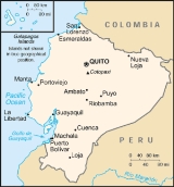
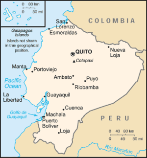
where they traveled overland to the Pacific, then sailed to Ecuador. In Ecuador, they split into two groups, traveling overland through rain forests, arriving in Quito in June 1736.
Bouguer, La Condamine, Godin and their colleagues measured arcs of the Earth’s curvature on the Equator from the plains near Quito to the southern city of Cuenca
. These measurements enabled the first accurate determination of the size of the Earth, eventually leading to the establishment of the international metric system
of measurement.
They completed their survey measurements by 1739, measuring the length of a meridian arc
of three degrees at the Equator. They did this in spite of earlier news that the expedition to Lapland led by Maupertuis
had already finished their work and had proven that the Earth is oblate, i.e., flattened at the poles. However, problems with astronomical observations kept them in Ecuador several more years.
Bouguer returned first from the expedition, going overland to the Caribbean
and then to France. La Condamine, along with Maldonado, returned by way of the Amazon River. Godin took a position as professor in Lima
, where he helped rebuild the city after the devastating 1746 earthquake
, and returned to Europe in 1751. Bouguer, La Condamine and the Spanish officers each wrote separate accounts of the expedition, which opened up European eyes to the exotic landscapes, flora and fauna of South America, and led directly to the great naturalist expeditions by Alexander von Humboldt
and others.
Expedition members first came across rubber tapping
(and thus rubber
), the identification of the correct types of cinchona
tree that produce the active form of quinine
(anti-malarial agent) and the development of what became the metric system for units of measure.
, later an important anthropologist
and founder of the Musée de l'Homme
in Paris.
In 1936, the French American Committee of Ecuador sponsored the idea of the Ecuadoran geographer Dr. Luis Tufiño and raised a monument commemorating the bicentennial of the arrival of the First Geodesic Mission. They raised a 10-meter-high monument
at Mitad del Mundo
in San Antonio de Pichincha
, in Pichincha Province
of Ecuador. However, there is no record that the Mission ever visited the area. Moreover, the monument bears a suspicious resemblance to a fictitious pyramid in Frederic Edwin Church's painting "Cayambe" rather than to any actual Ecuadorian site.
Ecuador
Ecuador , officially the Republic of Ecuador is a representative democratic republic in South America, bordered by Colombia on the north, Peru on the east and south, and by the Pacific Ocean to the west. It is one of only two countries in South America, along with Chile, that do not have a border...
carried out for the purpose of measuring the roundness of the Earth
Earth
Earth is the third planet from the Sun, and the densest and fifth-largest of the eight planets in the Solar System. It is also the largest of the Solar System's four terrestrial planets...
and measuring the length of a degree of longitude
Longitude
Longitude is a geographic coordinate that specifies the east-west position of a point on the Earth's surface. It is an angular measurement, usually expressed in degrees, minutes and seconds, and denoted by the Greek letter lambda ....
at the Equator
Equator
An equator is the intersection of a sphere's surface with the plane perpendicular to the sphere's axis of rotation and containing the sphere's center of mass....
. The mission was one of the first geodesic
Geodesic
In mathematics, a geodesic is a generalization of the notion of a "straight line" to "curved spaces". In the presence of a Riemannian metric, geodesics are defined to be the shortest path between points in the space...
(or geodetic) missions carried out under modern scientific principles, and the first major international scientific expedition.
Background
In the 18th century, there was significant debate in the scientific community, specifically in the French Academy of SciencesFrench Academy of Sciences
The French Academy of Sciences is a learned society, founded in 1666 by Louis XIV at the suggestion of Jean-Baptiste Colbert, to encourage and protect the spirit of French scientific research...
(Académie des sciences), as to whether the circumference of the Earth was greater around the Equator or around the poles. French astronomer Jacques Cassini
Jacques Cassini
Jacques Cassini was a French astronomer, son of the famous Italian astronomer Giovanni Domenico Cassini.Cassini was born at the Paris Observatory. Admitted at the age of seventeen to membership of the French Academy of Sciences, he was elected in 1696 a fellow of the Royal Society of London, and...
held to the view that the polar circumference was greater. Louis XV
Louis XV of France
Louis XV was a Bourbon monarch who ruled as King of France and of Navarre from 1 September 1715 until his death. He succeeded his great-grandfather at the age of five, his first cousin Philippe II, Duke of Orléans, served as Regent of the kingdom until Louis's majority in 1723...
, the King of France and the Academy sent two expeditions to determine the answer: one was sent to Lapland, close to the North Pole
North Pole
The North Pole, also known as the Geographic North Pole or Terrestrial North Pole, is, subject to the caveats explained below, defined as the point in the northern hemisphere where the Earth's axis of rotation meets its surface...
, under Swedish physicist Anders Celsius
Anders Celsius
Anders Celsius was a Swedish astronomer. He was professor of astronomy at Uppsala University from 1730 to 1744, but traveled from 1732 to 1735 visiting notable observatories in Germany, Italy and France. He founded the Uppsala Astronomical Observatory in 1741, and in 1742 he proposed the Celsius...
and French mathematician Pierre Maupertuis
Pierre Louis Maupertuis
Pierre-Louis Moreau de Maupertuis was a French mathematician, philosopher and man of letters. He became the Director of the Académie des Sciences, and the first President of the Berlin Academy of Science, at the invitation of Frederick the Great....
. The other mission was sent to Ecuador, at the Equator. Previous accurate measurements had been taken in Paris
Paris
Paris is the capital and largest city in France, situated on the river Seine, in northern France, at the heart of the Île-de-France region...
by Cassini and others.
Expedition
Astronomer
An astronomer is a scientist who studies celestial bodies such as planets, stars and galaxies.Historically, astronomy was more concerned with the classification and description of phenomena in the sky, while astrophysics attempted to explain these phenomena and the differences between them using...
s Charles Marie de La Condamine
Charles Marie de La Condamine
Charles Marie de La Condamine was a French explorer, geographer, and mathematician. He spent ten years in present-day Ecuador measuring the length of a degree latitude at the equator and preparing the first map of the Amazon region based on astronomical observations.-Biography:Charles Marie de La...
, Pierre Bouguer
Pierre Bouguer
Pierre Bouguer was a French mathematician, geophysicist, geodesist, and astronomer. He is also known as "the father of naval architecture"....
, Louis Godin
Louis Godin
Louis Godin was a French astronomer and member of the French Academy of Sciences. He worked in Peru, Spain, Portugal and France.-Biography:...
and Spanish geographers Jorge Juan
Jorge Juan y Santacilia
Jorge Juan y Santacilia was a Spanish mathematician, scientist, naval officer, and mariner.-Family and Education:...
and Antonio de Ulloa
Antonio de Ulloa
Antonio de Ulloa y de la Torre-Girault was a Spanish general, explorer, author, astronomer, colonial administrator and the first Spanish governor of Louisiana.Rebellion of 1768]]....
. They were accompanied by several assistants, including the naturalist Joseph de Jussieu
Joseph De Jussieu
Joseph de Jussieu, , was a French botanist, member of the Jussieu family. He introduced the common garden heliotrope into Europe.He was the brother of Bernard and Antoine de Jussieu,...
and Louis's cousin Jean Godin. La Condamine was joined in his journey down the Amazon
Amazon River
The Amazon of South America is the second longest river in the world and by far the largest by waterflow with an average discharge greater than the next seven largest rivers combined...
by Ecuadoran geographer and topographer
Topography
Topography is the study of Earth's surface shape and features or those ofplanets, moons, and asteroids...
Pedro Maldonado
Pedro Vicente Maldonado
Pedro Vicente Maldonado y Flores, was a South-American scientist who collaborated with the members of the French Geodesic Mission...
. (Maldonado later traveled to Europe to continue his scientific work.)
- Note: In the 18th century the nation of Ecuador did not yet exist. The area was under SpanishSpanish EmpireThe Spanish Empire comprised territories and colonies administered directly by Spain in Europe, in America, Africa, Asia and Oceania. It originated during the Age of Exploration and was therefore one of the first global empires. At the time of Habsburgs, Spain reached the peak of its world power....
control and was called the Territory of Quito after the city of QuitoQuitoSan Francisco de Quito, most often called Quito , is the capital city of Ecuador in northwestern South America. It is located in north-central Ecuador in the Guayllabamba river basin, on the eastern slopes of Pichincha, an active stratovolcano in the Andes mountains...
. The fame brought to the region by the French Geodesic Mission influenced the adoption of the name Republic of Ecuador when the country gained independence in 1830.
The Ecuadoran expedition left France
France
The French Republic , The French Republic , The French Republic , (commonly known as France , is a unitary semi-presidential republic in Western Europe with several overseas territories and islands located on other continents and in the Indian, Pacific, and Atlantic oceans. Metropolitan France...
in May 1735. They landed on the Caribbean
Caribbean
The Caribbean is a crescent-shaped group of islands more than 2,000 miles long separating the Gulf of Mexico and the Caribbean Sea, to the west and south, from the Atlantic Ocean, to the east and north...
coast in Colombia
Colombia
Colombia, officially the Republic of Colombia , is a unitary constitutional republic comprising thirty-two departments. The country is located in northwestern South America, bordered to the east by Venezuela and Brazil; to the south by Ecuador and Peru; to the north by the Caribbean Sea; to the...
, sailed to Panama
Panama
Panama , officially the Republic of Panama , is the southernmost country of Central America. Situated on the isthmus connecting North and South America, it is bordered by Costa Rica to the northwest, Colombia to the southeast, the Caribbean Sea to the north and the Pacific Ocean to the south. The...
where they traveled overland to the Pacific, then sailed to Ecuador. In Ecuador, they split into two groups, traveling overland through rain forests, arriving in Quito in June 1736.
Bouguer, La Condamine, Godin and their colleagues measured arcs of the Earth’s curvature on the Equator from the plains near Quito to the southern city of Cuenca
Cuenca, Ecuador
Cuenca is the capital of the Azuay Province. It is located in the highlands of Ecuador at about 2500 m above sea level...
. These measurements enabled the first accurate determination of the size of the Earth, eventually leading to the establishment of the international metric system
Metric system
The metric system is an international decimalised system of measurement. France was first to adopt a metric system, in 1799, and a metric system is now the official system of measurement, used in almost every country in the world...
of measurement.
They completed their survey measurements by 1739, measuring the length of a meridian arc
Meridian arc
In geodesy, a meridian arc measurement is a highly accurate determination of the distance between two points with the same longitude. Two or more such determinations at different locations then specify the shape of the reference ellipsoid which best approximates the shape of the geoid. This...
of three degrees at the Equator. They did this in spite of earlier news that the expedition to Lapland led by Maupertuis
Pierre Louis Maupertuis
Pierre-Louis Moreau de Maupertuis was a French mathematician, philosopher and man of letters. He became the Director of the Académie des Sciences, and the first President of the Berlin Academy of Science, at the invitation of Frederick the Great....
had already finished their work and had proven that the Earth is oblate, i.e., flattened at the poles. However, problems with astronomical observations kept them in Ecuador several more years.
Bouguer returned first from the expedition, going overland to the Caribbean
Caribbean
The Caribbean is a crescent-shaped group of islands more than 2,000 miles long separating the Gulf of Mexico and the Caribbean Sea, to the west and south, from the Atlantic Ocean, to the east and north...
and then to France. La Condamine, along with Maldonado, returned by way of the Amazon River. Godin took a position as professor in Lima
Lima
Lima is the capital and the largest city of Peru. It is located in the valleys of the Chillón, Rímac and Lurín rivers, in the central part of the country, on a desert coast overlooking the Pacific Ocean. Together with the seaport of Callao, it forms a contiguous urban area known as the Lima...
, where he helped rebuild the city after the devastating 1746 earthquake
1746 Lima-Callao earthquake
The 1746 Lima-Callao earthquake occurred at 22:30 local time on 28 October . The epicenter was located about 90 km north-northwest from Lima. It caused almost complete destruction of the capital Lima and the subsequent tsunami devastated the port city of Callao...
, and returned to Europe in 1751. Bouguer, La Condamine and the Spanish officers each wrote separate accounts of the expedition, which opened up European eyes to the exotic landscapes, flora and fauna of South America, and led directly to the great naturalist expeditions by Alexander von Humboldt
Alexander von Humboldt
Friedrich Wilhelm Heinrich Alexander Freiherr von Humboldt was a German naturalist and explorer, and the younger brother of the Prussian minister, philosopher and linguist Wilhelm von Humboldt...
and others.
Observations during the mission
- Ulloa and Juan visited the architectural Inca complex in San Agustin de Callo and subsequently wrote a descriptive document of what they observed at the ruins. Ulloa made a drawing of the ruins.
- The scientists witnessed two eruptions of the CotopaxiCotopaxiCotopaxi is a stratovolcano in the Andes Mountains, located about south of Quito, Ecuador, South America. It is the second highest summit in the country, reaching a height of...
volcano in 1743 and 1744.
Expedition members first came across rubber tapping
Rubber tapping
Rubber tapping is the process by which the sap is collected from a rubber tree. An incision is made in the tree's bark, which cuts through the planting cycle to optimise the latex yield....
(and thus rubber
Rubber
Natural rubber, also called India rubber or caoutchouc, is an elastomer that was originally derived from latex, a milky colloid produced by some plants. The plants would be ‘tapped’, that is, an incision made into the bark of the tree and the sticky, milk colored latex sap collected and refined...
), the identification of the correct types of cinchona
Cinchona
Cinchona or Quina is a genus of about 38 species in the family Rubiaceae, native to tropical South America. They are large shrubs or small trees growing 5–15 metres in height with evergreen foliage. The leaves are opposite, rounded to lanceolate and 10–40 cm long. The flowers are white, pink...
tree that produce the active form of quinine
Quinine
Quinine is a natural white crystalline alkaloid having antipyretic , antimalarial, analgesic , anti-inflammatory properties and a bitter taste. It is a stereoisomer of quinidine which, unlike quinine, is an anti-arrhythmic...
(anti-malarial agent) and the development of what became the metric system for units of measure.
Subsequent mission
In the late 19th century, the Academy of Sciences sent another mission to Ecuador at the behest of the International Association of Geodesy to confirm the results of the First Geodesic Mission and commemorate the relationship between the two republics. This second mission was led by Captain E. Maurain and several other military personnel during its tenure in Ecuador from 1901–1906. The only two members of the French mission to spend the entire time in Ecuador were Lieutenant (later General) Georges Perrier and medical officer Paul RivetPaul Rivet
Paul Rivet was a French ethnologist, who founded the Musée de l'Homme in 1937. He was also one of the founders of the Comité de vigilance des intellectuels antifascistes, an antifascist organization created in the wake of the February 6, 1934 far right riots.Rivet proposed a theory according to...
, later an important anthropologist
Anthropology
Anthropology is the study of humanity. It has origins in the humanities, the natural sciences, and the social sciences. The term "anthropology" is from the Greek anthrōpos , "man", understood to mean mankind or humanity, and -logia , "discourse" or "study", and was first used in 1501 by German...
and founder of the Musée de l'Homme
Musée de l'Homme
The Musée de l'Homme was created in 1937 by Paul Rivet for the 1937 Exposition Internationale des Arts et Techniques dans la Vie Moderne. It is the descendant of the Musée d'Ethnographie du Trocadéro, founded in 1878...
in Paris.
Monument
A reproduction of the pyramids that marked the baseline for measurement at Yaruqui (which was destroyed by Quito authorities in the 1740s) was erected in 1836, the centennial of the expedition, by the Rocafuerte administration of the nascent republic of Ecuador. This monument fell into disrepair over the next century but was rebuilt in 1936, minus its original French inscription, for the bicentennial of the first geodesic expedition along with a second pyramid at San Antonio de Pichincha on the equator. These monuments still exist today. The new Quito international airport will open in the Yaruqui valley in 2011 and will include a mural celebrating the Geodesic Mission.In 1936, the French American Committee of Ecuador sponsored the idea of the Ecuadoran geographer Dr. Luis Tufiño and raised a monument commemorating the bicentennial of the arrival of the First Geodesic Mission. They raised a 10-meter-high monument
Monument
A monument is a type of structure either explicitly created to commemorate a person or important event or which has become important to a social group as a part of their remembrance of historic times or cultural heritage, or simply as an example of historic architecture...
at Mitad del Mundo
Mitad del Mundo
The Mitad del Mundo is a tract of land owned by the prefecture of the province of Pichincha, Ecuador. It is located in the San Antonio parish of the canton of Quito, north of the center of Quito....
in San Antonio de Pichincha
San Antonio de Pichincha
San Antonio de Pichincha, or simply San Antonio, also but less frequently known by its older name San Antonio de Lulumpamba , is a rural parish of Quito Canton, Pichincha Province, Ecuador. The seat of the parish lies in an arid plain with sandy soil known as Lulumpamba...
, in Pichincha Province
Pichincha Province
Pichincha is a province of Ecuador located in the northern sierra region; its capital and largest city is Quito. It is bordered by Imbabura & Esmeraldas to the north, Cotopaxi & Santo Domingo de los Tsáchilas to the south, Napo & Sucumbíos to the east, and Esmeraldas & Santo Domingo de los...
of Ecuador. However, there is no record that the Mission ever visited the area. Moreover, the monument bears a suspicious resemblance to a fictitious pyramid in Frederic Edwin Church's painting "Cayambe" rather than to any actual Ecuadorian site.
Publications
- Relación histórica del viaje a la América meridional, Jorge Juan and Ulloa, 1748
- Figure de la terre determine, Bouguer, 1749
- Journal du voyage, La Condamine, 1751
- Le procès des étoiles, 1735–1771, ISBN 9782232101762, ISBN 9782232118623