

Mitad del Mundo
Encyclopedia

Pichincha Province
Pichincha is a province of Ecuador located in the northern sierra region; its capital and largest city is Quito. It is bordered by Imbabura & Esmeraldas to the north, Cotopaxi & Santo Domingo de los Tsáchilas to the south, Napo & Sucumbíos to the east, and Esmeraldas & Santo Domingo de los...
, Ecuador
Ecuador
Ecuador , officially the Republic of Ecuador is a representative democratic republic in South America, bordered by Colombia on the north, Peru on the east and south, and by the Pacific Ocean to the west. It is one of only two countries in South America, along with Chile, that do not have a border...
. It is located in the San Antonio parish of the canton of Quito
Quito (canton)
Quito, officially the Metropolitan District of Quito , is a canton in the province of Pichincha, Ecuador.-Governance:The canton is governed by the same mayor and city council that govern the city of Quito.-Population figures:...
, north of the center of Quito
Quito
San Francisco de Quito, most often called Quito , is the capital city of Ecuador in northwestern South America. It is located in north-central Ecuador in the Guayllabamba river basin, on the eastern slopes of Pichincha, an active stratovolcano in the Andes mountains...
.
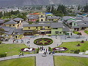
The grounds contain the Museo Etnográfico Mitad del Mundo, a museum about the indigenous ethnography
Ethnography
Ethnography is a qualitative method aimed to learn and understand cultural phenomena which reflect the knowledge and system of meanings guiding the life of a cultural group...
of Ecuador. The 30-meter-tall monument, built between 1979 and 1982, was constructed to mark the point where the equator
Equator
An equator is the intersection of a sphere's surface with the plane perpendicular to the sphere's axis of rotation and containing the sphere's center of mass....
passes through the country in the geodetic datum in use in Ecuador at that time. A line down the center of the east-facing staircase, and across the plaza, was meant to mark the equator, and countless tourists over the years have had their pictures taken straddling this line. In the modern datum of the World Geodetic System
World Geodetic System
The World Geodetic System is a standard for use in cartography, geodesy, and navigation. It comprises a standard coordinate frame for the Earth, a standard spheroidal reference surface for raw altitude data, and a gravitational equipotential surface that defines the nominal sea level.The latest...
(WGS84), which is used in GPS systems and computer mapping products like Google Earth
Google Earth
Google Earth is a virtual globe, map and geographical information program that was originally called EarthViewer 3D, and was created by Keyhole, Inc, a Central Intelligence Agency funded company acquired by Google in 2004 . It maps the Earth by the superimposition of images obtained from satellite...
, the equator is placed about 240 meters north of the marked line. This discrepancy is partially due to increased accuracy but primarily due to a different choice of mapping datum. Similarly, the line marking the Prime Meridian
Prime Meridian
The Prime Meridian is the meridian at which the longitude is defined to be 0°.The Prime Meridian and its opposite the 180th meridian , which the International Date Line generally follows, form a great circle that divides the Earth into the Eastern and Western Hemispheres.An international...
at the Royal Observatory, Greenwich
Royal Observatory, Greenwich
The Royal Observatory, Greenwich , in London, England played a major role in the history of astronomy and navigation, and is best known as the location of the prime meridian...
in England is roughly 100 meters from the exact zero of longitude as indicated by GPS receivers.
The pyramidal monument, with each side facing a cardinal direction, is topped by a 4.5 meter diameter, 5-ton
Ton
The ton is a unit of measure. It has a long history and has acquired a number of meanings and uses over the years. It is used principally as a unit of weight, and as a unit of volume. It can also be used as a measure of energy, for truck classification, or as a colloquial term.It is derived from...
globe. Inside the monument is a small museum that displays elements of indigenous Ecuadorian culture
Culture of Ecuador
The majority of the Ecuadorian population is mestizo, a mixture of both European and Amerindian ancestry, and much like their ancestry, the national culture is also a blend of these two sources, along with influences from Africa. 96% of Ecuador's population is German, Italian,and Spaniard descent...
, such as clothing, descriptions of the various ethnic groups, and examples of their activities. Mitad del Mundo contains other attractions such as a Planetarium, a miniature model of Quito, the capital of Ecuador, and restaurants. On weekends, Mitad del Mundo's Central Plaza is host to varied musical and cultural presentations for tourists.
A small town surrounding the monument at the Museo Etnográfico functions as the tourist center, replicating a colonial Spanish town and called "Ciudad Mitad del Mundo" (Middle of the World City). In this small town tourists can purchase many hand crafts that are made in Ecuador
Ecuador
Ecuador , officially the Republic of Ecuador is a representative democratic republic in South America, bordered by Colombia on the north, Peru on the east and south, and by the Pacific Ocean to the west. It is one of only two countries in South America, along with Chile, that do not have a border...
and enjoy local food at one of the many cafe´s
Finding the Equator
The area in the north of the province has been the object of a number of studies attempting to measure meridian arcMeridian arc
In geodesy, a meridian arc measurement is a highly accurate determination of the distance between two points with the same longitude. Two or more such determinations at different locations then specify the shape of the reference ellipsoid which best approximates the shape of the geoid. This...
in order to determine the exact figure of the Earth
Figure of the Earth
The expression figure of the Earth has various meanings in geodesy according to the way it is used and the precision with which the Earth's size and shape is to be defined. The actual topographic surface is most apparent with its variety of land forms and water areas. This is, in fact, the surface...
, with the first result being obtained in 1743 by Geodesic Mission
French Geodesic Mission
The French Geodesic Mission was an 18th-century expedition to what is now Ecuador carried out for the purpose of measuring the roundness of the Earth and measuring the length of a degree of longitude at the Equator...
of the French Academy of Sciences
French Academy of Sciences
The French Academy of Sciences is a learned society, founded in 1666 by Louis XIV at the suggestion of Jean-Baptiste Colbert, to encourage and protect the spirit of French scientific research...
, led by Louis Godin
Louis Godin
Louis Godin was a French astronomer and member of the French Academy of Sciences. He worked in Peru, Spain, Portugal and France.-Biography:...
, Pierre Bouguer
Pierre Bouguer
Pierre Bouguer was a French mathematician, geophysicist, geodesist, and astronomer. He is also known as "the father of naval architecture"....
and Charles Marie de La Condamine
Charles Marie de La Condamine
Charles Marie de La Condamine was a French explorer, geographer, and mathematician. He spent ten years in present-day Ecuador measuring the length of a degree latitude at the equator and preparing the first map of the Amazon region based on astronomical observations.-Biography:Charles Marie de La...
. From 1899-1906, General Georges Perrier, also with the backing of the French Academy of Sciences
French Academy of Sciences
The French Academy of Sciences is a learned society, founded in 1666 by Louis XIV at the suggestion of Jean-Baptiste Colbert, to encourage and protect the spirit of French scientific research...
, was sent to lead a mission to verify that result. Later, in 1936, with the support of the French American Committee, Ecuadorean geographer Dr. Luis Tufiño built a 10-meter monument in San Antonio de Pichincha to commemorate the first Geodesic Mission.
In 1979, the monument was moved 7 km to the to the town of Calacalí. Today, a new and much larger monument, Museo Etnográfico Mitad del Mundo, constructed between 1979 and 1982, stands in San Antonio de Pichincha. It is made of iron
Iron
Iron is a chemical element with the symbol Fe and atomic number 26. It is a metal in the first transition series. It is the most common element forming the planet Earth as a whole, forming much of Earth's outer and inner core. It is the fourth most common element in the Earth's crust...
and concrete
Concrete
Concrete is a composite construction material, composed of cement and other cementitious materials such as fly ash and slag cement, aggregate , water and chemical admixtures.The word concrete comes from the Latin word...
and covered with cut and polished andesite
Andesite
Andesite is an extrusive igneous, volcanic rock, of intermediate composition, with aphanitic to porphyritic texture. In a general sense, it is the intermediate type between basalt and dacite. The mineral assemblage is typically dominated by plagioclase plus pyroxene and/or hornblende. Magnetite,...
stone.
The exact specification of the equator is, in fact, somewhat variable and dependent on the chosen mathematical datum. A local private attraction, known as the Intiñan Solar Museum, claims to be built to mark the true location of the equator. The museum is an amusement for credulous tourists comparable to various "Mystery Spots" around the world. Tour guides and visitors perform demonstrations ostensibly possible only on the equator such as water flowing both counter-clockwise and clockwise down a drain, and balancing eggs on end. The truth, to which some tour guides will admit, is that latitude has no measurable influence on these tricks; they are not related to the proximity of the equator.
External links
- Mitad del Mundo, official website owned by the prefecture of Pichincha
- Quitsato sundial and middle of the world line of Mitad del Mundo, a large sundial located exactly on the equator
- Story of the Mitad del Mundo
- Article about Mitad del Mundo and nearby museum